Library Catalogue - Chetham's Library
Library Catalogue - Chetham's Library
Library Catalogue - Chetham's Library
Create successful ePaper yourself
Turn your PDF publications into a flip-book with our unique Google optimized e-Paper software.
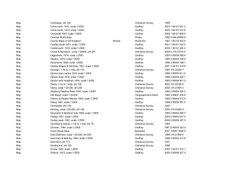
Map Colchester, sht 149<br />
Ordnance Survey 1956<br />
Map Colne north, 1910, scale 1:2500<br />
Godfrey 2003 1 84151 561 2<br />
Map Colne south, 1910, scale 1:2500<br />
Godfrey 2003 1 84151 572 8<br />
Map Compstall 1907, scale 1:2500<br />
Godfrey 2004 1 84151 609 0<br />
Map Concise World Atlas Philips 1992 0 540 05689 8<br />
Map County Maps of Old England Moulet<br />
Studio Ed. 1991 1 85170 403 5<br />
Map Cradley south,1901, scale 1:2500<br />
Godfrey 2001 1 84151 243 5<br />
Map Creekmouth, 1914, scale 1:2500<br />
Godfrey 2000 1 84151 204 4<br />
Map Crewe & Nantwich , scale 1:25000, sht 257<br />
Ordnance Survey 2005 0 319 23743 5<br />
Map Dagenham, 1914, scale 1:2500 Godfrey 1993 0 85054 568 4<br />
Map Dalston, 1870, scale 1:2500<br />
Godfrey 1995 0 85054 199 9<br />
Map Davyhulme 1894, scale 1:2500<br />
Godfrey 1996 0 85054 788 1<br />
Map Dawley Magna & Stirchley, 1901, scale 1:2500<br />
Godfrey 2001 1 84151 319 9<br />
Map Denbigh, 1 ins to 1 mile, sht 116<br />
Ordnance Survey 1997 319 22283 7<br />
Map Denton town centre 1918, scale 1:2500 Godfrey 1996 0 85054 811 X<br />
Map Denton west 1916, scale 1:2500 Godfrey 1998 0 85054 835 7<br />
Map Denton with Houghton 1904, scale 1:2500 Godfrey 1993 0 85054 601 X<br />
Map Derby, 1 ins to 1 mile, sht 128<br />
Ordnance Survey 2002 319 22728 6<br />
Map Derby, scale 1:25,000, sht 259<br />
Ordnance Survey 2000 319 21895 3<br />
Map Didsbury Palatine Road 1904, scale 1:2500<br />
Godfrey 1992 0 85054 524 2<br />
Map Die Mosel, scale 1:50,000 Topographische Karte 1995 3 89637 299 8<br />
Map Disbury & Heaton Mersey 1904, scale 1:2500<br />
Godfrey 1992 0 85054 512 9<br />
Map Disley 1907, scale 1:2500<br />
Godfrey 1998 0 85054 951 5<br />
Map Dorchester, sht 178<br />
Ordnance Survey 1945<br />
Map Dorking, scale 1:25,000, sht 146<br />
Ordnance Survey 2005 319 23584 X<br />
Map Droylsden & Medlock Vale 1906, scale 1:2500<br />
Godfrey 1993 0 85054 594 3<br />
Map Dudley 1901, scale 1:2500 Godfrey 2003 0 85054 937 X<br />
Map Dudley west, 1901, scale 1:2500 Godfrey 2006 0 85054 397 5<br />
Map Dumfries & Grenta, 1 ins to 1 mile, sht 75<br />
Ordnance Survey 1965<br />
Map Dunstan, 1894, scale 1:2500 Godfrey 1981 0 85054 243 X<br />
Map Dutch Street Atlas Baedeker 2007 3 8297 3526 X<br />
Map East Dearham, scale 1:25,000, sht 238<br />
Ordnance Survey 1999 319 21869 4<br />
Map East Ham & Barking, 1894, scale 1:2500 Godfrey 1996 0 85054 373 8<br />
Map East Kent, sht 173<br />
Ordnance Survey 1947<br />
Map Eastbourne, sht 183<br />
Ordnance Survey 1946<br />
Map Eccles 1905, scale 1:2500 Godfrey 2003 1 84151 570 1<br />
Map Elswick, 1913, scale 1:2500<br />
Godfrey 2000 0 85054 257 X


