

Library Catalogue - Chetham's Library
Library Catalogue - Chetham's Library
Library Catalogue - Chetham's Library

You also want an ePaper? Increase the reach of your titles
YUMPU automatically turns print PDFs into web optimized ePapers that Google loves.
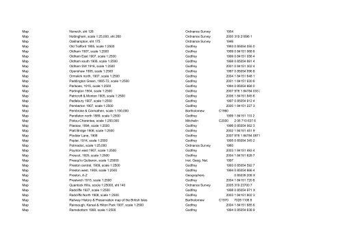
Map Norwich, sht 126<br />
Ordnance Survey 1954<br />
Map Nottingham, scale 1:25,000, sht 260<br />
Ordnance Survey 2000 319 21896 1<br />
Map Oakhampton, sht 175<br />
Ordnance Survey 1946<br />
Map Old Trafford 1905, scale 1:2500 Godfrey 1993 0 85054 055 0<br />
Map Oldham 1907, scale 1:2500 Godfrey 1999 0 84151 068 8<br />
Map Oldham East 1907, scale 1:2500 Godfrey 1999 0 84151 056 4<br />
Map Oldham south 1906, scale 1:2500 Godfrey 1998 0 85054 991 4<br />
Map Oldham SW 1916, scale 1:2500 Godfrey 2001 0 84151 302 4<br />
Map Openshaw 1905, scale 1:2500<br />
Godfrey 1987 0 85054 096 8<br />
Map Ormskirk north, 1907, scale 1:2500<br />
Godfrey 2004 1 84151 648 1<br />
Map Paddington Green, 1865-72, scale 1:2500 Godfrey 2001 1 84151 930 8<br />
Map Parlsoes, 1915, scale 1:2500<br />
Godfrey 1994 0 85054 668 0<br />
Map Partington 1904, scale 1:2500<br />
Godfrey 2007 978 1 84784 033 2<br />
Map Patricroft & Monton 1905, scale 1:2500<br />
Godfrey 2006 1 84151 945 6<br />
Map Pedlebury 1907, scale 1:2500<br />
Godfrey 1997 0 85054 912 4<br />
Map Pemberton 1907, scale 1:2500<br />
Godfrey 2000 1 84151 227 3<br />
Map Pembroke & Carmathen, scale 1:100,000<br />
Bartholomew C1960<br />
Map Pendleton north 1889, scale 1:2500 Godfrey 1999 1 84151 110 2<br />
Map Piotou-Charentes, scale 1:250,000 Mitchelin<br />
C2000 2 06 710 637 6<br />
Map Plastow, 1894, scale 1:2500<br />
Godfrey 1996 0 85054 062 3<br />
Map Platt Bridge 1906, scale 1:2500 Godfrey 2002 1 84151 451 9<br />
Map Plodder Lane, 1908 Godfrey 2007 978 1 84784 087 5<br />
Map Poplar, 1914, scale 1:2500 Godfrey 1995 0 85054 345 2<br />
Map Potmadoc, scale 1:25,000<br />
Ordnance Survey 1960<br />
Map Poynton east 1907, scale 1:2500<br />
Godfrey 2003 1 84151 493 4<br />
Map Prescot, 1925, scale 1:2500<br />
Godfrey 2004 1 84151 628 7<br />
Map Presqu'io Quiberon, scale 1:25000<br />
Inst. Geog. Nat. 1997<br />
Map Preston central, 1909, scale 1:2500 Godfrey 1993 0 85054 592 7<br />
Map Preston west, 1909, scale 1:2500 Godfrey 1994 0 85054 666 4<br />
Map Preston, A-Z Geographers 0 85039 208 X<br />
Map Prestwich 1915, scale 1:2500<br />
Godfrey 2004 1 84151 720 8<br />
Map Quantock Hills, sca;le 1:25000, sht 140<br />
Ordnance Survey 2005 319 23700 7<br />
Map Radcliffe 1927, scale 1:2500 Godfrey 1998 0 85054 971 X<br />
Map Radcliffe North 1908, scale 1:2500 Godfrey 2003 1 84151 602 3<br />
Map Railway History & Preservation map of the British Isles Bartholomew C1970 7028 1106 8<br />
Map Rainsough, Kersal & Hilton Park 1907, scale 1:2500<br />
Godfrey 2004 1 84151 685 6<br />
Map Ramsbottom 1908, scale 1:2500<br />
Godfrey 1994 0 85054 638 9