Grizzly Bear (Ursus arctos), Prairie Population - Publications du ...
Grizzly Bear (Ursus arctos), Prairie Population - Publications du ...
Grizzly Bear (Ursus arctos), Prairie Population - Publications du ...
Create successful ePaper yourself
Turn your PDF publications into a flip-book with our unique Google optimized e-Paper software.
Recovery Strategy for the <strong>Grizzly</strong> <strong>Bear</strong>, <strong>Prairie</strong> <strong>Population</strong> 2009<br />
3. APPENDIX 1<br />
Spatial analysis<br />
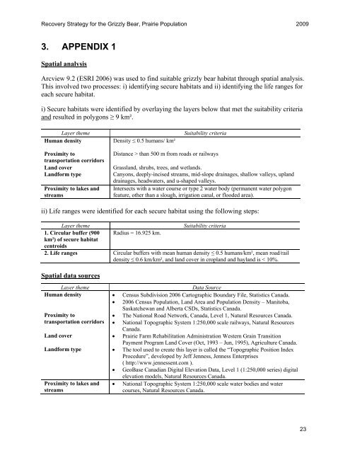
Arcview 9.2 (ESRI 2006) was used to find suitable grizzly bear habitat through spatial analysis.<br />
This involved two processes: i) identifying secure habitats and ii) identifying the life ranges for<br />
each secure habitat.<br />
i) Secure habitats were identified by overlaying the layers below that met the suitability criteria<br />
and resulted in polygons ≥ 9 km².<br />
Layer theme Suitability criteria<br />
Human density Density ≤ 0.5 humans/ km²<br />
Proximity to<br />
transportation corridors<br />
Distance > than 500 m from roads or railways<br />
Land cover Grassland, shrubs, trees, and wetlands.<br />
Landform type Canyons, deeply-incised streams, mid-slope drainages, shallow valleys, upland<br />
drainages, headwaters, and u-shaped valleys.<br />
Proximity to lakes and Intersects with a water course or type 2 water body (permanent water polygon<br />
streams<br />
feature, other than a slough, irrigation canal, or flooded area).<br />
ii) Life ranges were identified for each secure habitat using the following steps:<br />
Layer theme Suitability criteria<br />
1. Circular buffer (900 Radius = 16.925 km.<br />
km²) of secure habitat<br />
centroids<br />
2. Life ranges Circular buffers with mean human density ≤ 0.5 humans/km², mean road/rail<br />
density ≤ 0.6 km/km², and land cover in cropland and hayland is < 10%.<br />
Spatial data sources<br />
Layer theme Data Source<br />
Human density � Census Subdivision 2006 Cartographic Boundary File, Statistics Canada.<br />
� 2006 Census <strong>Population</strong>, Land Area and <strong>Population</strong> Density – Manitoba,<br />
Proximity to<br />
transportation corridors<br />
Saskatchewan and Alberta CSDs, Statistics Canada.<br />
� The National Road Network, Canada, Level 1, Natural Resources Canada.<br />
� National Topographic System 1:250,000 scale railways, Natural Resources<br />
Canada.<br />
Land cover � <strong>Prairie</strong> Farm Rehabilitation Administration Western Grain Transition<br />
Payment Program Land Cover (Oct, 1993 – Jun, 1995), Agriculture Canada.<br />
Landform type � The tool used to create this layer is called the “Topographic Position Index<br />
Proce<strong>du</strong>re”, developed by Jeff Jenness, Jenness Enterprises<br />
( http://www.jennessent.com ).<br />
� GeoBase Canadian Digital Elevation Data, Level 1 (1:250,000 series) digital<br />
Proximity to lakes and<br />
streams<br />
elevation models, Natural Resources Canada.<br />
� National Topographic System 1:250,000 scale water bodies and water<br />
courses, Natural Resources Canada.<br />
23


