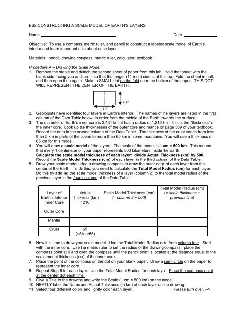
ES2 CONSTRUCTING A SCALE MODEL OF EARTH'S LAYERS ...
ES2 CONSTRUCTING A SCALE MODEL OF EARTH'S LAYERS ...
ES2 CONSTRUCTING A SCALE MODEL OF EARTH'S LAYERS ...

You also want an ePaper? Increase the reach of your titles
YUMPU automatically turns print PDFs into web optimized ePapers that Google loves.
<strong>ES2</strong> <strong>CONSTRUCTING</strong> A <strong>SCALE</strong> <strong>MODEL</strong> <strong>OF</strong> EARTH’S <strong>LAYERS</strong>NameDateObjective: To use a compass, metric ruler, and pencil to construct a labeled scale model of Earth’sinterior and learn important data about each layer.Materials: pencil, drawing compass, metric ruler, calculator, textbookProcedure A – Drawing the Scale Model1. Remove the staple and detach the second sheet of paper from this lab. Hold that sheet with theblank side facing you and turn it so that the longer (11-inch) side is at the top. Fold the sheet in half,and then open it up again. Make a SMALL dot on the fold near the bottom of the paper. THIS DOTWILL REPRESENT THE CENTER <strong>OF</strong> THE EARTH.11”2. Geologists have identified four layers in Earth’s interior. The names of the layers are listed in the firstcolumn of the Data Table below, in order from the middle of the Earth towards the surface.3. The diameter of Earth’s inner core is 2,431 km; it has a radius of 1,216 km – this is the “thickness” ofthe inner core. Look up the thicknesses of the outer core and mantle on page 309 of your textbook.Record the data in the second column of the Data Table. The thickness of the crust varies from lessthan 5 km in parts of the ocean to more than 65 km in some mountains. You will use a thickness of65 km for this model.4. You will draw a scale model of the layers. The scale of the model is 1 cm = 500 km. This meansthat every 1 centimeter on your paper represents 500 kilometers inside the Earth.Calculate the scale model thickness of each layer: divide Actual Thickness (km) by 500.Record the Scale Model Thickness (cm) of each layer in the third column of the Data Table.5. Draw your scale model using a drawing compass to draw the outer edge of each layer from thecenter of the Earth. To do this, you need to calculate the Total Model Radius (cm) for each layer.Do this by adding the scale model thickness of a layer (column 2) to the total model radius of theprevious layer in the fourth column of the Data Table.8.5”Layer of ActualEarth’s Interior Thickness (km)Inner Core 1216Outer CoreMantleCrust 65(65)Scale Model Thickness (cm)(= column 2 ÷ 500)Total Model Radius (cm)(= scale thickness +previous line)6. Now it is time to draw your scale model. Use the Total Model Radius data from column four. Startwith the inner core. Use the metric ruler to set the radius of the drawing compass: place thecompass point at 0 and open the compass until the pencil point is located at the distance equal to thescale model thickness (cm) of the inner core.7. Place the point of the compass on the dot on your blank paper. Draw a semi-circle on the paper torepresent the inner core.8. Repeat Step 6 for each layer. Use the Total Model Radius for each layer. Place the compass pointat the center dot each time.9. Give a Title to the drawing and write the Scale (1 cm = 500 km) on the model.10. NEATLY label the Name and Actual Thickness (in km) of each layer on the drawing.11. Select four different colors and lightly color each layer. Please turn over. -->
Procedure B – Tabulating DataComplete the Properties of Earth’s Layers Data Table. It is on the back side of the Scale Model Drawing.Use your textbook to find the required information about each layer. Most of the information is in Chapter11 on page 309.(a) Name of Layer (already entered on chart)(b) Thickness of Layer – for crust, do NOT list “65 km”; give a range of thicknesses.(c) State of Matter – is the layer solid or liquid? For the mantle, write “solid, parts weak rock that canflow”(d) Composition – list the names of the major elements in each layer(e) Average Density – use these values: Inner Core 12.7-13.0 g/cm 3 ; Outer Core 9.9-12.2 g/cm 3 ;Mantle 3.3-5.5 g/cm 3 ; Crust – list two types: Ocean crust (Basalt) 3.1 g/cm 3 and Continental crust(Granite) 2.7 g/cm 3 .(f) Temperature Range and (g) Miscellaneous Notes – we will fill in these columns in class.Questions – Use your scale model, data table, and text to answer the following questions. IN SOMECASES, YOU WILL NEED TO LOOK UP INFORMATION IN YOUR TEXTBOOK.1. Describe the overall pattern of densities of Earth’s layers, beginning at Earth’s surface.2. Look up the term “Mohorovicic discontinuity” in the textbook – use the Index to find the page number.The nickname for this layer is the “MOHO”. What is the MOHO and where is it located?TRACE the “MOHO” on your scale model diagram and LABEL it.3. Which layer of Earth’s interior is the thickest?4. Which layer of Earth is thinnest?5. Look up the terms lithosphere and asthenosphere in your textbook. (Use the Index to find the pagenumbers.) Define each in the space below. Include the names of the layers in which each is located.lithosphereLocated in which layer(s)?asthenosphereLocated in which layer(s)?Make an inference: Which zone, the lithosphere or the asthenosphere, is made of denser rock? Howcan you tell?6. How is the Outer Core different from the Inner Core?7. Make some inferences about the following characteristics.The deeper you go into Earth’s interior, the PRESSURE will: (circle one)increase decrease stay the sameThe deeper you go into Earth’s interior, the TEMPERATURE will: (circle one)increase decrease stay the same


![';1asAu ro; las I sgeo8 leuo!]eslanuol aql utelqo o1 palenttouJ ue I ...](https://img.yumpu.com/49072782/1/190x221/1asau-ro-las-i-sgeo8-leuoeslanuol-aql-utelqo-o1-palenttouj-ue-i-.jpg?quality=85)