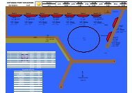
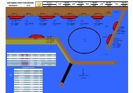
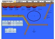
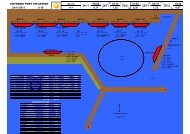
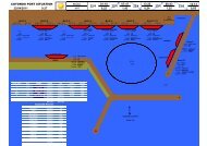
MaputoAccess SpecificationMap reference number and Description Length (m) Draught (m)Coastal terminal 300 8General cargo terminal I 200 11General cargo terminal D 200 9General cargo terminal C 200 9Steel / Granite / Project cargo terminal 200 10.5Container terminal 300 11Sugar terminal 170 10.5Citrus terminal 380 11Molasses terminal 179 10.5The port of Maputo is the largest port in <strong>Mozambique</strong> and is ideally situated as it is the closest port to the industrialheartland of South Africa. All berths have between 7,0m and 11.0m draft alongside and entrance to Maputo is viaCanal du Nort. Pilotage / tugs is compulsory in daylight hours only and pilots board at Buoy 6. Berthing / sailing ispresently only permitted during daylight hours. The port of Maputo normally works 24 hours a day, seven days aweek.
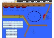
MaputoNew dredging access (Sept 4th, 2012)3799(P)/12 MOZAMBIQUE - Baía de Maputo - Baixo Fawn to Barra Norte - Depths. BuoyageSource: Maputo Port Development Company1. A channel, maintained depth 11·0m, has been dredged into the Port of Maputo. The channel extends 50m either side of aline joining the following positions:25° 38´·10S., 32° 53´·02E.25° 39´·22S., 32° 52´·51E.25° 46´·21S., 32° 49´·63E.25° 49´·78S., 32° 50´·80E.25° 52´·75S., 32° 51´·42E.25° 55´·46S., 32° 51´·53E.25° 56´·01S., 32° 44´·32E.25° 57´·53S., 32° 39´·02E.25° 59´·53S., 32° 35´·33E.25° 59´·28S., 32° 34´·69E.25° 58´·56S., 32° 33´·81E.25° 57´·74S., 32° 32´·66E.25° 57´·28S., 32° 31´·73E.25° 57´·26S., 32° 31´·46E.25° 57´·31S., 32° 31´·15E.25° 57´·42S., 32° 30´·89E.25° 57´·60S., 32° 30´·47E.25° 57´·88S., 32° 29´·71E.2. A recommended route exists in the centre of the channel between positions 25° 38´·10S. 32° 53´·02E. and25° 56´·01S., 32° 44´·32E.3. Lateral buoys are located in the centre of the channel. Vessels must pass as close as possible to these buoys on theappropriate side.4. Light-buoy ’1N’ (25° 38´·13S., 32° 53´·06E.) has been reported as unlit.5. Light-buoy ‘8’ (25° 56´·89S., 32° 41´·25E.) has been reported missing.6. Canal do Sul is closed to navigation. Light-buoys ‘1S’ (25° 54´·64S., 32° 56´·17E.) and ‘2S’ (25° 53´·39S., 32° 55´·18E.)have been removed.(All positions are referred to WGS84 Datum)7. These changes will be included in the next New Editions of Chart 644, to be published November 2012, and Chart 646, tobe published in 2013.Charts affected - 644 – 6463738* MOZAMBIQUE - Baía de Maputo - Baixo Fawn to Barra Norte - Depths. Buoyage.Recommended track.Source: Maputo Port Development Company & Fugro Survey Africa LtdChart 644 [ previous update 2105/12 ] WGS84 DATUMInsert the accompanying block, showing amendments to depths,buoyage and recommended track, centred on: 25° 48´·95S., 32° 51´·10E.Wk34/