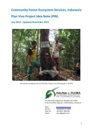
Download PIN - Plan Vivo
Download PIN - Plan Vivo
Download PIN - Plan Vivo
- No tags were found...

Create successful ePaper yourself
Turn your PDF publications into a flip-book with our unique Google optimized e-Paper software.
Choiseul <strong>PIN</strong> V1.0 12022013 used to determine group membership and tribal land boundaries. This situation applies to the producer communities in this project. Land in Sasamungga is owned by two separate tribal groups. The two tribes were Sirebe tribe and Vuri tribe. The two tribes claim to be the rightful owners of the land and they have customary land use rights over the land. Sirebe tribal land in Sasamungga is owned by the Sirebe tribe, who have written documents to show and prove that they are the rightful owners of the land. The Vuri sub-‐tribal land is part of the main Sikipozo tribal land in Sasamungga. It is land allocated to the Vuri sub-‐tribe by the Sikipozo tribe. The Vuri land and project site belongs to Myknee Sirikolo’s Father (1 st born son) and his two younger brothers; it is one of the three sub divisions of land allocated from main Sikipozo tribal land. There are written records of the land ownership rights demonstrating that the land is owned by Vuri tribe. Sambe land is owned by a particular tribe called Borovai. The majority of the Borovai tribal group live in the village called Ngorreambarra and few people currently reside upon or use the Sambe land where the project is proposed. The land area involved in this REDD+ project is considered land held under customary tenure. While this is legally recognised, further legal recognition of actual land boundaries is required. Live & Learn as project coordinator will work with the customary landowners to determine the most efficient and effective avenue for recognized tenure through the Customary Land Recording Act [Cap 132], local court ruling (Choiseul Provincial Ordinance) or through the Protected Areas Act (which has provision for legal recognition of customary land ownership and boundaries). A preliminary anthropological assessment commissioned by Live & Learn suggests that there is a clear pathway for determining legal land tenure and use rights for the participating groups, this conclusion was largely based upon the level of informal agreements between the neighbouring tribes. Legal determination of land boundaries and associated mapping would be a significant focus of project development going forward. Sources: The Constitution of Solomon Islands [no.783], 1978. Customary Land Recording Act [Cap 132]. Protected Areas Act, 2010 Rapid Assessment of Perceptions (RAP) Report, 2011, Live & Learn Environmental Education, Solomon Islands. Official letters from landowners of Vuri and Sirebe Tribal Groups (Live & Learn are still waiting on a letter from the Borovae tribal group). 14