MARINE SAFETY INVESTIGATION REPORT No. 200
MARINE SAFETY INVESTIGATION REPORT No. 200
MARINE SAFETY INVESTIGATION REPORT No. 200

Create successful ePaper yourself
Turn your PDF publications into a flip-book with our unique Google optimized e-Paper software.
6<br />
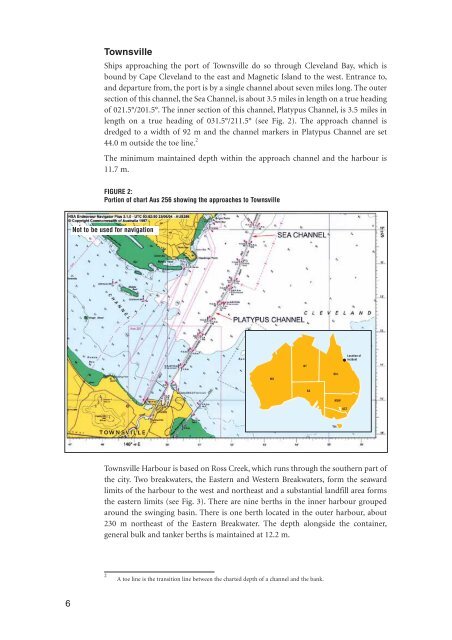
Townsville<br />
Ships approaching the port of Townsville do so through Cleveland Bay, which is<br />
bound by Cape Cleveland to the east and Magnetic Island to the west. Entrance to,<br />
and departure from, the port is by a single channel about seven miles long. The outer<br />
section of this channel, the Sea Channel, is about 3.5 miles in length on a true heading<br />
of 021.5°/201.5°. The inner section of this channel, Platypus Channel, is 3.5 miles in<br />
length on a true heading of 031.5°/211.5° (see Fig. 2). The approach channel is<br />
dredged to a width of 92 m and the channel markers in Platypus Channel are set<br />
44.0 m outside the toe line. 2<br />
The minimum maintained depth within the approach channel and the harbour is<br />
11.7 m.<br />
FIGURE 2:<br />
Portion of chart Aus 256 showing the approaches to Townsville<br />
<strong>No</strong>t to be used for navigation<br />
Townsville Harbour is based on Ross Creek, which runs through the southern part of<br />
the city. Two breakwaters, the Eastern and Western Breakwaters, form the seaward<br />
limits of the harbour to the west and northeast and a substantial landfill area forms<br />
the eastern limits (see Fig. 3). There are nine berths in the inner harbour grouped<br />
around the swinging basin. There is one berth located in the outer harbour, about<br />
230 m northeast of the Eastern Breakwater. The depth alongside the container,<br />
general bulk and tanker berths is maintained at 12.2 m.<br />
2<br />
A toe line is the transition line between the charted depth of a channel and the bank.<br />
WA<br />
NT<br />
SA<br />
Qld.<br />
NSW<br />
Tas.<br />
ACT<br />
Location of<br />
incident