Surface motion of mountain glaciers derived from satellite optical ...
Surface motion of mountain glaciers derived from satellite optical ...
Surface motion of mountain glaciers derived from satellite optical ...

Create successful ePaper yourself
Turn your PDF publications into a flip-book with our unique Google optimized e-Paper software.
20E. Berthier et al. / Remote Sensing <strong>of</strong> Environment 95 (2005) 14–2819 August 2003 (image pair #1) are also combined toestimate the displacement during 31 days. This pair is usedto test a less favourable <strong>satellite</strong> configuration (with adifference <strong>of</strong> 8.58 in the incidence angles) and to determinewhether the <strong>glaciers</strong> can experience short-term velocitychange.All these images were acquired with the lowest possiblegain. A low gain avoids radiometric saturation on theglacier, especially in the bright snow-covered accumulationarea (Ferrigno & Williams, 1983). Level 1A imagery is usedto avoid any radiometric and geometric resampling <strong>of</strong> thedata. This level ensures better control <strong>of</strong> the image geometry(Al-Rousan et al., 1997).3.2. Digital elevation model (DEM)To model and remove the stereoscopic distortionsbetween two images, a DEM is needed. Because <strong>mountain</strong><strong>glaciers</strong> in the Mont Blanc area are experiencing rapidthinning (Berthier et al., 2004), a DEM referring to an epochas near in time as possible to the acquisition date <strong>of</strong> the<strong>satellite</strong> images seems preferable. The SPOT5 imagesacquired on 19 and 23 August 2003 with opposite incidenceangles and a short time separation (Table 1) were combinedto compute a fine resolution DEM <strong>of</strong> the area, with a posting<strong>of</strong> 20 m. The DEM was produced using the Orthoenginemodule <strong>of</strong> the PCI-Geomatica s<strong>of</strong>tware (Toutin & Cheng,2002). The accuracy <strong>of</strong> this DEM was tested with 48independent check-points on the slopes surroundings the<strong>glaciers</strong>. The mean difference between the SPOT5 DEM andthe check-points is 2.5 m (r=10 m), the DEM being slightlylower. On the flat surface <strong>of</strong> the Mer de Glace andArgentière <strong>glaciers</strong>, this difference is only 0.15 m (r=1.1m). Because <strong>of</strong> shadowing, clouds and the difference inareal coverage, this DEM does not encompass the entirearea <strong>of</strong> interest. A complete DEM is needed and obtainedusing the SRTM DEM (Rabus et al., 2003) and anotherSPOT DEM available for 2000. The coarse GTOPO30DEM (USGS, 1996) was also used to prove that accuratedisplacements can be <strong>derived</strong> without any precise, contemporaneousDEM.3.3. Ground control points (GCPs)Some GCPs are preferable to improve the absolutegeoreferencing <strong>of</strong> the four SPOT5 scenes. They have beenacquired in September and October 2003 with an ASH-TECH single-frequency differential GPS (DGPS) system.The accuracy <strong>of</strong> these GCP positions is on the order <strong>of</strong> 0.5m horizontally and 1 m vertically. They are used in theabsolute orientation <strong>of</strong> the images (step 1). During thecomputation <strong>of</strong> the stereo model, the least reliable GCPs areexcluded. Table 2 provides some statistics on the GCPsretained. For the different SPOT5 images, the same set <strong>of</strong>GCPs leads to slightly different residuals ranging <strong>from</strong> 1.55to 2.55 m. Table 2 also shows the results <strong>of</strong> the relativeorientation for the different pairs <strong>of</strong> images (last column).For image pair #2, the orientation is greatly improved. Forthis pair, the relative orientation is also accurate withoutGCPs, even when using the less precise GTOPO30 DEM.For image pair #1, the relative orientation does not lead toany improvement because <strong>of</strong> the less favourable <strong>satellite</strong>configuration. The significant 8.58 difference in the incidenceangles <strong>of</strong> the two images in pair #1 also explains whythe relative orientation is inaccurate without GCPs, evenwith a precise DEM.3.4. DGPS measurements <strong>of</strong> the glacier displacementMeasurement <strong>of</strong> glacier displacements <strong>from</strong> <strong>satellite</strong>images are rarely compared to field measurements becauseit is difficult to be on the <strong>glaciers</strong> during the exact time <strong>of</strong>acquisition <strong>of</strong> <strong>satellite</strong> images. Two DGPS field campaignswere planned on the Mer de Glace and Argentière <strong>glaciers</strong>in August and September 2003 to measure the surfacedisplacements. Because <strong>of</strong> possible cloud cover and the<strong>satellite</strong> schedule, the acquisition dates <strong>of</strong> the SPOT5images could not be known precisely in advance. Con-Table 2Standard deviation <strong>of</strong> the residuals (meters) for the absolute and relative orientation <strong>of</strong> the different SPOT5 scenesImage pair Date (2003) Abs. orient. Rel. orient.r Max. residual r Max. residual#1 with GCPs; HR DEM 19 Jul 2.55 4.3 2.84 11.119 Aug 1.89 3.59#1 no GCPs; HR DEM 19 Jul/19 Aug – – 5.45 31.7#1 no GCPs; LR DEM 19 Jul/19 Aug – – 14.5 38.8#2 with GCPs; HR DEM 23 Aug 1.55 2.66 0.63 1.4518 Sep 1.82 2.97#2 no GCPs; HR DEM 23 Aug/18 Sep – – 0.67 1.68#2 no GCPs; LR DEM 23 Aug/18 Sep – – 0.67 1.68For each image, the absolute orientation is computed <strong>from</strong> ground control points (GCPs). The relative orientation is based on homologous points extracted bycross-correlation <strong>of</strong> the two images and does not necessary require an absolute orientation beforehand. The maximum residual for the GCPs (respectivelyhomologous points) retained in the absolute (resp. relative) orientation is also given. HR refers to the high resolution (20 m) DEM and LR to the low resolution(1 km) GTOPO30 DEM.
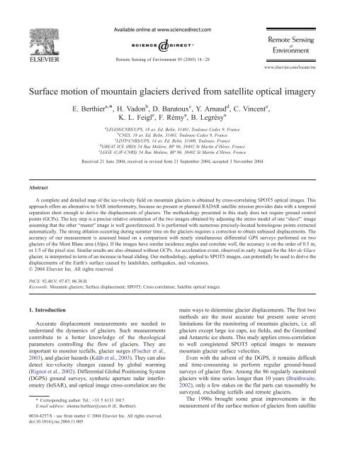
E. Berthier et al. / Remote Sensing <strong>of</strong> Environment 95 (2005) 14–28 21Fig. 4. Comparison between the acquisition times <strong>of</strong> the SPOT5 images and the DGPS surveys <strong>of</strong> the <strong>glaciers</strong> displacements. For the DGPS survey, M refers tothe Mer de Glace glacier, A to the Argentière Glacier.sequently, the ground surveys were not performed exactly atthe same time (Fig. 4). A Leica dual-frequency GPS wasused to survey the two successive positions <strong>of</strong> 29 ablationstakes and painted stones on the <strong>glaciers</strong>. The precision <strong>of</strong>the positioning itself is on the order <strong>of</strong> a few centimeters.The main uncertainty results <strong>from</strong> the difficulty in placing theGPS antenna exactly at the same position relative to the stakes(a puddle <strong>of</strong> water usually surrounds each stake in summertime).Consequently, the uncertainty is 15 cm for a singlemeasurement, leading to a displacement accuracy <strong>of</strong> F21 cm.For painted stones, the uncertainty is larger, but difficult toestimate because they can move or roll independently <strong>of</strong> theunderlying ice.4. Results4.1. Map <strong>of</strong> the displacements in the Mont Blanc areaFig. 5 shows the horizontal displacement <strong>of</strong> the groundsurface in the Mont Blanc area <strong>derived</strong> <strong>from</strong> image pair #2.On these <strong>glaciers</strong>, no overall velocity measurements hadever been performed. The highest speed occurs on thesteep icefalls <strong>of</strong> the Mer de Glace, Bosson and Brenva<strong>glaciers</strong>, with velocities over 500 m a 1 . Some small-scalefeatures <strong>of</strong> the displacement field also appear clearly. Forexample, the increase in velocity <strong>of</strong> the Mer de Glaceglacier near the confluence with the Leschaux glacier isvisible in Fig. 5d. Some problems also appear. Nodisplacements can be measured for areas in shadows;e.g., on the upper part <strong>of</strong> the Leschaux glacier under thesteep north face <strong>of</strong> the Grandes Jorasses. At high elevationon the accumulation zone, even with a low gain, the noiseremains noticeable.4.2. Residuals in the unglaciarized areaThe accuracy <strong>of</strong> the velocities can be first assessed by anull test over <strong>motion</strong>less, ice-free areas <strong>of</strong> the images. Weretain only the points with a correlation coefficient over 0.7.Fig. 6 shows the histograms <strong>of</strong> the residuals (in meters) inthe image line direction for image pair #2. As expected, thestronger the correlation coefficient, the smaller the scatter. Ifthe correlation coefficient is greater than 0.95, the uncertainty(noted r) is 1.8 m whereas r=6.6 m if the correlationcoefficient is smaller than 0.75. Unexpectedly, the histogramsare not exactly centered on 0. Furthermore, theweaker the correlation coefficient, the more negative theaverage residual (bias) in the line direction.We suggest that the change in solar illumination angleexplains this bias (Fig. 7). between the two acquisitiondates, the Sun has moved, changing the orientation andlength <strong>of</strong> its shadows. The apparent displacement <strong>of</strong> theshadows is negative and oriented mainly parallel to imagelines. The strength <strong>of</strong> the correlation is weakened by asecondary correlation peak due to the shifted shadows. Thelarger the shadow, the larger the shift between the two datesand the weaker the correlation coefficient. We verify thishypothesis by comparing the residuals <strong>of</strong>f the <strong>glaciers</strong> in theimage line direction for two different slopes. The southeastfacingslopes, oriented toward the Sun at 9:00 AM localsolar time (when the <strong>satellite</strong> images were acquired), presentshort shadows and, consequently, have high correlationcoefficients and small residuals. The northwest-facingslopes, where the shadows are large, present low correlationcoefficient and strong, negative residuals in the linedirection.However, on the <strong>glaciers</strong>, this bshadowing effectQ doesnot cause a systematic error in our measurements. Shadowsare only created by the surficial debris and the surrounding<strong>mountain</strong>s. The best way to ensure a limited bias is to retainonly the measurements with the highest correlation coefficient.The effect could be larger for other applications suchas landslides, especially if images are acquired duringdifferent seasons.Table 3 gives the <strong>of</strong>fsets <strong>of</strong>f the <strong>glaciers</strong> for both imagepairs in column and line directions. The bshadowing effectQalso affects the residuals in lines for image pair #1, but theeffect is small because the illumination angle <strong>of</strong> the Sun didnot change much between the two images. In bothdirections, the standard deviation is larger for pair #1 thanfor pair #2 because <strong>of</strong> the difference in the incidence angles<strong>of</strong> the two images (Table 1). Even with a precise DEM, thedistortions between the images could not be perfectlymodelled and suppressed.Our images were acquired for glaciological purposeswith a low gain: digital numbers are ranging <strong>from</strong> 10 to 30<strong>of</strong>f the <strong>glaciers</strong> and <strong>from</strong> 30 to 200 on the <strong>glaciers</strong>.Consequently, the strength <strong>of</strong> the correlation peak is muchlarger on the <strong>glaciers</strong>. It is thus difficult to transpose readilythe uncertainties estimated on the steep slopes surroundingthe <strong>glaciers</strong> to the <strong>glaciers</strong>. Only DGPS observations canprovide a precise estimation <strong>of</strong> the accuracy <strong>of</strong> our method.4.3. Comparison with DGPS displacementsTo cover the same length <strong>of</strong> time, the <strong>satellite</strong>-<strong>derived</strong>displacements (occurring in 26 or 31 days) and the DGPS
22E. Berthier et al. / Remote Sensing <strong>of</strong> Environment 95 (2005) 14–28Fig. 5. Horizontal displacement <strong>of</strong> <strong>glaciers</strong> <strong>of</strong> the Mont Blanc area between the 23 August and 18 September 2003 (26 days). The upper panel (a) shows theentire Mont Blanc area. The white outlines encompass the Argentière, Brenva, and Mer de Glace <strong>glaciers</strong> shown in the three lower panels (b, c, and d),respectively. Where the correlation coefficient is too weak, pixels appear in grey. The white dots are the ablation stakes measured by DGPS. The black line isthe longitudinal pr<strong>of</strong>ile on the Mer de Glace glacier shown in Fig. 8. The black arrows in the three lower panels indicate the direction <strong>of</strong> flow.
24E. Berthier et al. / Remote Sensing <strong>of</strong> Environment 95 (2005) 14–28magnitude or the direction <strong>of</strong> the ice flow is knownaccurately, the differences between the real and the<strong>satellite</strong>-<strong>derived</strong> column displacements could be convertedto changes <strong>of</strong> elevation.Fig. 7. Effect <strong>of</strong> the Sun’s illumination angle on 23 August and 18September 2003 on the length and orientation <strong>of</strong> the shadows. This effectexplains why some unglaciarized areas present, mostly in the image linedirection, some negative residuals.<strong>from</strong> a simple empirical degree-day model tuned with fieldmeasurements (Vincent, 2002). Each positive degree at agiven altitude on the glacier yields an ablation <strong>of</strong> 6.6 mm <strong>of</strong>ice. The temperature is calculated <strong>from</strong> the records <strong>of</strong> thenearby Chamonix weather station assuming a constantadiabatic lapse rate <strong>of</strong> 6 8/km. Between 19 July and 19August 2003, the estimated ablation is on the order <strong>of</strong> 3 m <strong>of</strong>ice at 1900 m on the glacier. Combined with the 248incidence angle <strong>of</strong> the 19 July 2003 image, we calculate thatour method overestimates the column <strong>of</strong>fset by 1.3 m. Thisvalue is the same as the shift observed in Fig. 8. We accountfor this effect by modeling the ablation <strong>of</strong> the ice.The correction is made by lowering, in the DEM, thesurface <strong>of</strong> the <strong>glaciers</strong> with the estimated ablation. Thecorrect ground position (k i ,/ s ,z s in Fig. 9) <strong>of</strong> the imagepoint (x+Dx,y+Dy) is deduced <strong>from</strong> this corrected DEM.New values <strong>of</strong> the column displacements are obtained andadded to Fig. 8 (grey triangles). This simple modellingcorrects most <strong>of</strong> the systematic shift in the columndisplacements. The uncertainty <strong>of</strong> the estimation <strong>of</strong> theelevation change <strong>from</strong> the degree-day model is large, on theorder <strong>of</strong> 30%. At 1900 m, it contributes F0.4 m <strong>of</strong>uncertainty to the column displacement measurement forimage pair #1 and F0.13 m for image pair #2.Pairs <strong>of</strong> images acquired with similar and large incidenceangles could be used to measure precisely elevation changeon <strong>glaciers</strong>, or more generally, on the Earth’s surface. If the4.3.2. Accuracy <strong>of</strong> the <strong>satellite</strong>-<strong>derived</strong> displacementsFinally, we compare the DGPS and SPOT5-<strong>derived</strong>displacements. At the location <strong>of</strong> each stake, we extract thevalue <strong>of</strong> the displacements in column, line, and thecorrelation coefficient for each <strong>satellite</strong> image pair. Ofthe 29 stakes surveyed, 12 are located on the Mer deGlace glacier, and 17 on the Argentière Glacier. In Table4, we present the results <strong>of</strong> the comparison. Some <strong>of</strong> thedifferences could result <strong>from</strong> the temporal mismatchbetween the dates <strong>of</strong> surveys (Fig. 4) and <strong>from</strong> theuncertainties in the DGPS measurements (F21 cm). Thistable underlines the high accuracy obtained for both imagepairs. As expected, the rms discrepancy is generallysmaller for image pair #2 (on the order <strong>of</strong> 0.5 m in bothimage directions) than for image pair #1 (around 1 m). Forall 29 stakes, the absolute differences between SPOT andDGPS displacements are on the order <strong>of</strong> 1/5 <strong>of</strong> the pixelsize (0.5 m) except in the line direction for image pair #2.When considering each glacier independently, the resultsare slightly different.For the Mer de Glace glacier, the most importantdifferences appear in the line direction for image pair #2.We believe that this difference cannot be explained by anerror in the <strong>satellite</strong> measurement and is, therefore, a realvelocity change <strong>of</strong> the glacier. First, the accuracy is twotimes better for pair #2 than for pair #1, as shown by thestandard deviations in Table 4. We also expect thedisplacements in the line direction to be the most accuratebecause the stereoscopic effect and errors due to ablationaffect the column direction only. The bshadowing effectQdescribed previously could explain a systematic error inthe image line direction. But shadows are limited on<strong>glaciers</strong> and, if they were present, would lead to anapparent acceleration <strong>of</strong> the Mer de Glace glacier. Thesedifferences could result <strong>from</strong> a short-term velocity change<strong>of</strong> the Mer de Glace glacier discussed below.4.4. Accuracy without GCPs and with a coarse DEMAs explained previously, our methodology can beapplied without GCPs by skipping the step <strong>of</strong> theTable 3Mean and standard deviation (in parentheses), in meters, <strong>of</strong> the residuals <strong>of</strong>f the <strong>glaciers</strong> for different correlation coefficients intervalsImage pair 0.7–0.75 0.75–0.8 0.8–0.85 0.85–0.9 0.9–0.95 0.95–1#1 Col. 0.20 (12.34) 0.16 (10.46) 0.16 (8.27) 0.05 (6.32) 0.10 (4.74) 0.20 (4.24)Lin. 0.48 (14.04) 0.41 (11.44) 0.34 (8.40) 0.21 (5.60) 0.10 (3.28) 0.02 (2.35)#2 Col. 0.30 (5.33) 0.31 (4.58) 0.28 (3.68) 0.23 (2.84) 0.14 (1.96) 0.06 (1.47)Lin. 1.21 (6.57) 1.11 (5.63) 0.96 (4.54) 0.74 (3.52) 0.47 (2.46) 0.22 (1.81)Residuals in column (Col.) and line (Lin.) directions for the two pairs <strong>of</strong> images are presented. Note that the standard deviations are roughly twice as small forimage pair #2. Also, note the relation between the residuals in lines and the correlation coefficient caused by the bshadowing effectQ (see text).
E. Berthier et al. / Remote Sensing <strong>of</strong> Environment 95 (2005) 14–28 25Fig. 8. Displacements along a longitudinal pr<strong>of</strong>ile <strong>of</strong> the Mer de Glace glacier in the column image direction deduced <strong>from</strong> the 19 July and 19 August 2003image pair. All displacements were rescaled to 26 days. The small light grey squares are the displacements <strong>from</strong> SPOT images along a single pr<strong>of</strong>ile, whereasthe black triangles represent the mean <strong>of</strong> 5 parallel pr<strong>of</strong>iles separated by 25 m. The white diamonds are the DGPS displacements. The black circles (filled inwhite) represent the correlation coefficient <strong>of</strong> the <strong>satellite</strong> measurement (right axis). The grey triangles represent the <strong>satellite</strong> displacements after correction forablation.Fig. 9. Difference between the real and measured displacements caused bylowering <strong>of</strong> the glacier surface. This systematic error only affectsmeasurements in the column direction.absolute orientation. Consequently, we obtain two wellcoregistered images but with a shift relative to the DEM.The stereoscopic effect is less well modelled so thatsome distortions remain between the two images. Wechoose image pair #2 to test the accuracy obtainedwithout GCPs because this pair presents a weak stereoscopiceffect. The relative orientation <strong>of</strong> the two imagesis not significantly better with GCPs as shown in Table2. The comparison with the DGPS survey (Table 4)confirms that accurate displacements can be obtainedwithout GCPs. It is interesting to note that the differenceis even smaller in some locations. We obtain a similaraccuracy when using the GTOPO30 DEM (also withoutGCPs) instead <strong>of</strong> the high resolution DEM. It indicatesthat, with a good image pair, our methodology can beapplied to remote areas where no high resolution DEMis available. The main limitation in using a coarse DEMis that elevation errors in the DEM, combined with non-
26E. Berthier et al. / Remote Sensing <strong>of</strong> Environment 95 (2005) 14–28Table 4Mean and standard deviation (in parentheses), in meters, <strong>of</strong> the differencebetween the displacements <strong>derived</strong> <strong>from</strong> SPOT5 images and measuredduring a differential GPS field campaignImage pair Argentière Mer de Glace All data#1 Col. 0.38 (0.71) 0.6 (0.34) 0.49 (0.56)Lin. 0.65 (0.93) 0.39 (0.38) 0.53 (0.72)#2 Col. 0.22 (0.47) 0 (0.4) 0.12 (0.45)Lin. 0.47 (0.53) 1.33 (0.46) 0.85 (0.66)#2 no GCPs Col. 0.28 (0.46) 0.01 (0.47) 0.16 (0.45)Lin. 0.52 (0.6) 1.2 (0.33) 0.84 (0.6)#2 no GCPs Col. 0.07 (0.43) 0.35 (0.42) 0.12 (0.47)GTOPO30 Lin. 0.54 (0.65) 1.29 (0.44) 0.88 (0.67)The <strong>of</strong>fsets in columns (Col.) and lines (Lin.) for the two image pairs andalso image pair #2 without GCPs (with the high resolution DEM and theGTOPO30 DEM) are presented.vertical incidence angles, will result in georeferencingerrors. They can lead to significant displacement errorsin areas where the velocity gradient is large, which isnot the case near our DGPS surveys, located close to theglacier centerline.4.5. A likely ice-acceleration event on the Mer de GlaceglacierFig. 10 shows that a velocity change may affect that part<strong>of</strong> the Mer de Glace glacier located between the Géanticefall and its confluence with the Leschaux glacier. Themean velocity change between image pair #1 and #2 for thispart <strong>of</strong> the pr<strong>of</strong>ile is 12.6 m a 1 or 11.6% in 30 days. TheDGPS velocities are even slightly greater than the onededuced <strong>from</strong> image pair #1, dating the ice-accelerationevent in mid-August 2003. Such rapid summer velocitychanges <strong>of</strong> <strong>glaciers</strong> have been reported previously. They areusually explained by higher sliding velocities due to higherbasal water pressures (e.g., Mair et al., 2001). In earlyAugust 2003, a pronounced heat wave baked Europe,increasing the surface melting on <strong>glaciers</strong> in the Alps. Thisrapid water input could explain the increase in basal waterpressure and sliding on part <strong>of</strong> the Mer de Glace glacier. InFig. 10. Horizontal surface velocities along a longitudinal pr<strong>of</strong>ile <strong>of</strong> the Mer de Glace glacier determined <strong>from</strong> <strong>satellite</strong> images and DGPS surveys.
E. Berthier et al. / Remote Sensing <strong>of</strong> Environment 95 (2005) 14–28 27future work, a more detailed study <strong>of</strong> the spatial pattern <strong>of</strong>the velocity change will help better understand the causes <strong>of</strong>this ice-acceleration event.5. ConclusionsThe goal <strong>of</strong> measuring displacements on <strong>mountain</strong><strong>glaciers</strong> with an accuracy <strong>of</strong> one fourth the pixel size(0.62 m with SPOT5 images) has been achieved. Theuncertainty in the DGPS survey (0.21 cm), the temporalmismatch between the ground surveys, and the acquisitiondates <strong>of</strong> the SPOT5 images, combined with a suddenincrease in ice-velocity prevent us <strong>from</strong> confirming definitivelythe accuracy <strong>from</strong> field observations. Yet, anuncertainty <strong>of</strong> 0.5 m in each image direction seemsreasonable if <strong>satellite</strong> images are acquired <strong>from</strong> a similarpoint <strong>of</strong> view. This uncertainty <strong>of</strong> 0.5 m over 26 days isequivalent to 2 cm over 1 day, very close to the accuracyobtained <strong>from</strong> InSAR using ERS-1/ERS-2 tandem pairs.Our approach is accurate enough to measure a 10% velocityincrease on the Mer de Glace glacier during and just afterthe pronounced heat wave in Europe in early August 2003.Because our approach does not require GCPs, ourmethodology can be routinely and rapidly applied to newpairs <strong>of</strong> images. The high accuracy obtained without GCPsusing the GTOPO30 DEM suggests the possibility <strong>of</strong>monitoring numerous <strong>glaciers</strong>, even in remote areas andwithout a contemporaneous DEM. The key step is the relativeorientation <strong>of</strong> the two correlated images using precisehomologous points. The accuracy <strong>of</strong> the measurement iscontrolled mainly by the radiometry (low gain is better for<strong>glaciers</strong> to avoid sensor saturation) and the geometry <strong>of</strong> theimages. The bshadowingQ effect, highlighted on the <strong>motion</strong>lessarea surrounding the <strong>glaciers</strong>, could be a problem for theapplications other than glaciology. The rapidly changingelevation <strong>of</strong> <strong>mountain</strong> <strong>glaciers</strong> in summertime, because <strong>of</strong>ablation, can create a systematic error in the displacementsalong the image column direction. Addressing this issue,however, requires external information. This systematic biascould be used to monitor the elevation change <strong>of</strong> <strong>glaciers</strong>throughout the ablation season.Images acquired <strong>from</strong> a similar point <strong>of</strong> view, withincidence angles differing only by a few degrees, are best.Vertical incidence eliminates the systematic errors caused byablation but such a constraint also reduces the likelihood <strong>of</strong>obtaining two good images.Among the limitations <strong>of</strong> our approach is that a velocitymeasurement during the summer may not be representative<strong>of</strong> the annual dynamics <strong>of</strong> a glacier. Thus, annual surveys <strong>of</strong>ablation stakes on a few <strong>glaciers</strong> are needed and complementthe <strong>satellite</strong>-<strong>derived</strong> measurements. Another limitationis the difficulty in acquiring two cloud-free images withsimilar incidence angles.Other geological phenomena that deforms the Earth’ssurface, such as earthquakes, landslides, and volcanoescould also be surveyed using the cross-correlation <strong>of</strong> SPOT5images. Depending on the expected direction <strong>of</strong> displacements,the incidence angles could be chosen for optimumaccuracy. For mostly horizontal (respectively vertical)displacements, images with vertical (respectively oblique)incidence angles are preferable. For these applications otherthan glaciology, one interesting and promising topic toexplore would be the fusion <strong>of</strong> displacements obtained byInSAR and <strong>optical</strong> image cross-correlation to obtain a 3-dimensional surface-displacement map.AcknowledgmentsAurélie Bouilllon provided useful help concerning theSPOT5 algorithms. The comments <strong>of</strong> R. S. Williams Jr. andan anonymous reviewer led to significant improvements <strong>of</strong>the manuscript. We thank M. Bauer who provided valuableguidance as Editor-in-Chief. SPOT5 images were acquiredthanks to the ISIS program (copyright CNES). This workwas supported by the French national program ACI-OTGlaciers, the GDR STRAINSAR and the French GLACIO-CLIM program. The LGGE and IRD Great Ice Unitprovided support for the field experiment. GMT s<strong>of</strong>tware(Wessel & Smith, 1998) illustrated the article. The firstauthor gratefully acknowledges a thesis fellowship <strong>from</strong> theFrench government.ReferencesAl-Rousan, N., Cheng, P., Petrie, G., Toutin, T., & Valadan Zoej, M. (1997).Automated DEM extraction and orthoimage generation <strong>from</strong> SPOTlevel 1B imagery. Photogrammetric Engineering and Remote Sensing,63, 965–974.Berthier, E., Arnaud, Y., Baratoux, D., Vincent, C., & Rémy, F. (2004).Recent rapid thinning <strong>of</strong> the bMer de glaceQ glacier <strong>derived</strong> <strong>from</strong><strong>satellite</strong> <strong>optical</strong> images. Geophysical Research Letters, 31(17)doi10.1029/2004GLO20706.Berthier, E., Raup, B., & Scambos, T. A. (2003). New velocity map andmass-balance estimate <strong>of</strong> Mertz Glacier, East Antarctica, <strong>derived</strong> <strong>from</strong>Landsat sequential imagery. Journal <strong>of</strong> Glaciology, 49(167).Braithwaite, R. J. (2002). Glacier mass balance: the first 50 years<strong>of</strong> international monitoring. Progress in Physical Geography, 26(1),76–95.Centre National d’Etude Spatiale, (2002). MEDICIS s<strong>of</strong>tware, distributedby CSSI.Ferrigno, J. G., & Williams, R. S., Jr. (1983). Limitations in the use <strong>of</strong>Landsat images for mapping and others purposes in snow- and icecoveredregions: Antarctica, Iceland and Cape Code, Massachusetts.International Symposium on Remote Sensing <strong>of</strong> Environment 17th,vol. 1. (pp. 335–355) Ann Arbor, Michigan7 Environmental ResearchInstitute <strong>of</strong> Michigan.Fischer, A., Rott, H., & Bjfrnsson, H. (2003). Observation <strong>of</strong> recent surges<strong>of</strong> Vatnajfkull, Iceland, by means <strong>of</strong> ERS SAR interferometry. Annals<strong>of</strong> Glaciology, 37, 69–76.Fratter, D., Moulin, M., Ruiz, H., & Charvet, P. D. Z. (2001). The SPOT-5mission. 52nd International Astronautical Congress. Toulouse, France.Frezzotti, M., Capra, A., & Vittuari, L. (1998). Comparison between glacierice velocities inferred <strong>from</strong> GPS and sequential <strong>satellite</strong> images. Annals<strong>of</strong> Glaciology, 27, 54–60.