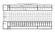
Forest Operations on Crown Land - Ministry of Tourism
Forest Operations on Crown Land - Ministry of Tourism
Forest Operations on Crown Land - Ministry of Tourism
- No tags were found...

Create successful ePaper yourself
Turn your PDF publications into a flip-book with our unique Google optimized e-Paper software.
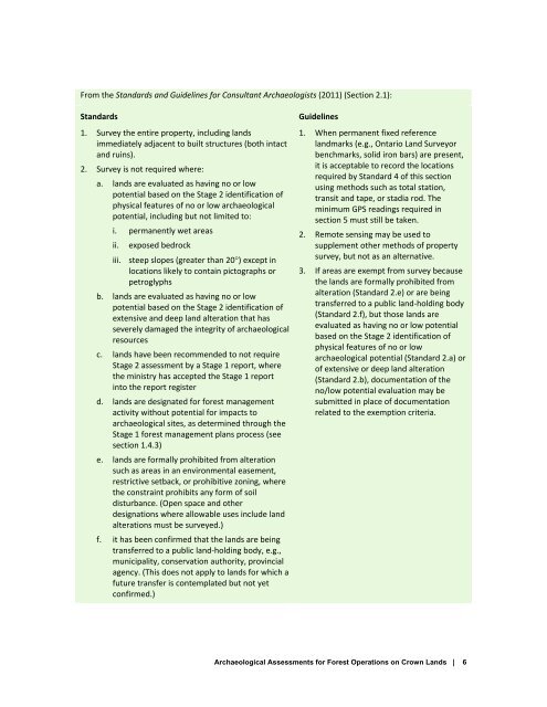
From the Standards and Guidelines for C<strong>on</strong>sultant Archaeologists (2011) (Secti<strong>on</strong> 2.1):Standards1. Survey the entire property, including landsimmediately adjacent to built structures (both intactand ruins).2. Survey is not required where:a. lands are evaluated as having no or lowpotential based <strong>on</strong> the Stage 2 identificati<strong>on</strong> <strong>of</strong>physical features <strong>of</strong> no or low archaeologicalpotential, including but not limited to:i. permanently wet areasii.exposed bedrockiii. steep slopes (greater than 20) except inlocati<strong>on</strong>s likely to c<strong>on</strong>tain pictographs orpetroglyphsb. lands are evaluated as having no or lowpotential based <strong>on</strong> the Stage 2 identificati<strong>on</strong> <strong>of</strong>extensive and deep land alterati<strong>on</strong> that hasseverely damaged the integrity <strong>of</strong> archaeologicalresourcesc. lands have been recommended to not requireStage 2 assessment by a Stage 1 report, wherethe ministry has accepted the Stage 1 reportinto the report registerd. lands are designated for forest managementactivity without potential for impacts toarchaeological sites, as determined through theStage 1 forest management plans process (seesecti<strong>on</strong> 1.4.3)e. lands are formally prohibited from alterati<strong>on</strong>such as areas in an envir<strong>on</strong>mental easement,restrictive setback, or prohibitive z<strong>on</strong>ing, wherethe c<strong>on</strong>straint prohibits any form <strong>of</strong> soildisturbance. (Open space and otherdesignati<strong>on</strong>s where allowable uses include landalterati<strong>on</strong>s must be surveyed.)f. it has been c<strong>on</strong>firmed that the lands are beingtransferred to a public land‐holding body, e.g.,municipality, c<strong>on</strong>servati<strong>on</strong> authority, provincialagency. (This does not apply to lands for which afuture transfer is c<strong>on</strong>templated but not yetc<strong>on</strong>firmed.)Guidelines1. When permanent fixed referencelandmarks (e.g., Ontario <strong>Land</strong> Surveyorbenchmarks, solid ir<strong>on</strong> bars) are present,it is acceptable to record the locati<strong>on</strong>srequired by Standard 4 <strong>of</strong> this secti<strong>on</strong>using methods such as total stati<strong>on</strong>,transit and tape, or stadia rod. Theminimum GPS readings required insecti<strong>on</strong> 5 must still be taken.2. Remote sensing may be used tosupplement other methods <strong>of</strong> propertysurvey, but not as an alternative.3. If areas are exempt from survey becausethe lands are formally prohibited fromalterati<strong>on</strong> (Standard 2.e) or are beingtransferred to a public land‐holding body(Standard 2.f), but those lands areevaluated as having no or low potentialbased <strong>on</strong> the Stage 2 identificati<strong>on</strong> <strong>of</strong>physical features <strong>of</strong> no or lowarchaeological potential (Standard 2.a) or<strong>of</strong> extensive or deep land alterati<strong>on</strong>(Standard 2.b), documentati<strong>on</strong> <strong>of</strong> theno/low potential evaluati<strong>on</strong> may besubmitted in place <strong>of</strong> documentati<strong>on</strong>related to the exempti<strong>on</strong> criteria.Archaeological Assessments for <str<strong>on</strong>g>Forest</str<strong>on</strong>g> <str<strong>on</strong>g>Operati<strong>on</strong>s</str<strong>on</strong>g> <strong>on</strong> <strong>Crown</strong> <strong>Land</strong>s | 6
![THIS AGREEMENT made this [date], between [name of owner] (the ...](https://img.yumpu.com/49827605/1/158x260/this-agreement-made-this-date-between-name-of-owner-the-.jpg?quality=85)