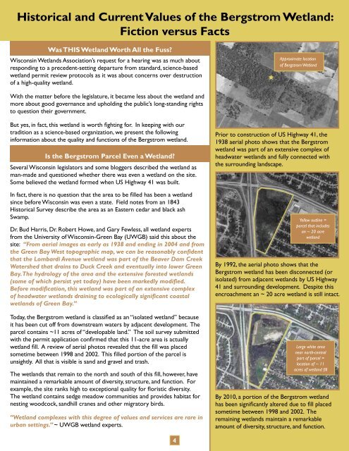
Historical and Current Values of the Bergstrom Wetland:Fiction versus FactsWas THIS Wetland Worth All the Fuss?<strong>Wisconsin</strong> <strong>Wetlands</strong> <strong>Association</strong>’s request for a hearing was as much aboutresponding to a precedent-setting departure from standard, science-basedwetland permit review protocols as it was about concerns over destructionof a high-quality wetland.Approximate locationof Bergstrom WetlandWith the matter before the legislature, it became less about the wetland andmore about good governance and upholding the public’s long-standing rightsto question their government.But yes, in fact, this wetland is worth fighting for. In keeping with ourtradition as a science-based organization, we present the followinginformation about the quality and functions of the Bergstrom wetland.Is the Bergstrom Parcel Even a Wetland?Several <strong>Wisconsin</strong> legislators and some bloggers described the wetland asman-made and questioned whether there was even a wetland on the site.Some believed the wetland formed when US Highway 41 was built.In fact, there is no question that the area to be filled has been a wetlandsince before <strong>Wisconsin</strong> was even a state. Field notes from an 1843Historical Survey describe the area as an Eastern cedar and black ashSwamp.Dr. Bud Harris, Dr. Robert Howe, and Gary Fewless, all wetland expertsfrom the University of <strong>Wisconsin</strong>-Green Bay (UWGB) said this about thesite: “From aerial images as early as 1938 and ending in 2004 and fromthe Green Bay West topographic map, we can be reasonably confidentthat the Lombardi Avenue wetland was part of the Beaver Dam CreekWatershed that drains to Duck Creek and eventually into lower GreenBay. <strong>The</strong> hydrology of the area and the extensive forested wetlands(some of which persist yet today) have been markedly modified.Before modification, this wetland was part of an extensive complexof headwater wetlands draining to ecologically significant coastalwetlands of Green Bay.”Today, the Bergstrom wetland is classified as an “isolated wetland” becauseit has been cut off from downstream waters by adjacent development. <strong>The</strong>parcel contains ~11 acres of “developable land.” <strong>The</strong> soil survey submittedwith the permit application confirmed that this 11-acre area is actuallywetland fill. A review of aerial photos revealed that the fill was placedsometime between 1998 and 2002. This filled portion of the parcel isunsightly. All that is visible is sand and gravel and trash.<strong>The</strong> wetlands that remain to the north and south of this fill, however, havemaintained a remarkable amount of diversity, structure, and function. Forexample, the site ranks high to exceptional quality for floristic diversity.<strong>The</strong> wetland contains sedge meadow communities and provides habitat fornesting woodcock, sandhill cranes and other migratory birds.“Wetland complexes with this degree of values and services are rare inurban settings.” ~ UWGB wetland experts.Prior to construction of US Highway 41, the1938 aerial photo shows that the Bergstromwetland was part of an extensive complex ofheadwater wetlands and fully connected withthe surrounding landscape.Yellow outline =parcel that includesan ~ 20 acrewetlandBy 1992, the aerial photo shows that theBergstrom wetland has been disconnected (orisolated) from adjacent wetlands by US Highway41 and surrounding development. Despite thisencroachment an ~ 20 acre wetland is still intact.Large white areanear north-centralpart of parcel =location of ~ 11acres of wetland fillBy 2010, a portion of the Bergstrom wetlandhas been significantly altered due to fill placedsometime between 1998 and 2002. <strong>The</strong>remaining wetlands maintain a remarkableamount of diversity, structure, and function.4
Is the Bergstrom Wetland Overrun by Invasive Species?Project proponents (Bergstrom’s attorney, some legislators, and cabinet-level DNR administrators) said the site was mostly orsoon to be completely over-run by invasive species and that what was being proposed was in the best interest of the wetlands.Tufted LoosestrifeTrained scientists offered a different perspective. For example:<strong>The</strong> DNR Wildlife Biologist stated: “Primarily Phragmites was present only onthe disturbed portions near the highway fence and already filled in portionsof what probably was a larger wetland complex. In the proposed wetland tofill, few invasives were present.”Woodcock NestWetland experts from UWGB concluded: “Additional alteration of thehydrology that results in drier conditions will also further degrade theremaining wetlands by increasing erosion and creating conditions that arefavorable for the spread of Phragmites australis and other invasive species…increasing human alteration of these wetlands will only exacerbate thealready precarious ecological integrity and biodiversity at this site.”<strong>The</strong> UWGB wetland experts also noted: “Any increase in disturbance byhuman activities will reduce the nesting value for Woodcock and SandhillCrane, and will degrade breeding, stopover, foraging, and protective coverhabitat for amphibians, deer, small mammals, and other resident andmigratory wetland vertebrate species.” ~ Memo from Dr. Bud Harris, Dr.Robert Howe, and Gary Fewless to <strong>Wisconsin</strong> <strong>Wetlands</strong> <strong>Association</strong>.If a Developer Creates More Acres of <strong>Wetlands</strong> than are Destroyed,Why isn’t Wetland Enhancement and Mitigation Always a Reasonable Solution?<strong>Wetlands</strong> are complex and valuable components of <strong>Wisconsin</strong>’s landscape. In recognitionof the public benefits wetlands provide, state and federal laws discourage development inwetlands by requiring that projects be designed to first avoid, and then minimize, wetlandimpacts.While wetland mitigation is an important tool to help compensate for unavoidablewetland impacts, scientists agree that acreage alone is not a reliable indicator of whetherthe area restored is better than, or even comparable to, what’s been destroyed.<strong>The</strong>re was no evidence inDNR’s files that any qualifiedstaff (i.e., those with trainingand expertise in wetlandecology and site evaluation)agreed that the proposedenhancements adequatelyoffset the proposed fill.This is because wetlands develop over the course of thousands of years based on theecological processes of the surrounding land and water. Wetland functions are site-specific and can be difficult to replicate,particularly when the wetland to be filled is high quality, such as the Bergstrom wetland. Some wetland types (e.g., floodplainforests) can’t be replicated at all, and many mitigation projects fail to restore wetland hydrology or vegetation.Even when a wetland of comparable size, type, and quality is successfully created elsewhere on the landscape, the locallyimportant functions such as flood storage, water quality improvement, and wildlife habitat are lost from the filled site forever.This can be particularly problematic in urban areas, where few wetlands remain to provide these critical services.<strong>The</strong>se shortcomings do not mean that mitigation should never be allowed, but the promise of mitigation should not be used tojustify the unnecessary destruction of high quality wetlands. In the case of the Bergstrom wetland, alternative locations for theproject within the proposed 300-acre redevelopment (TIF) district were not adequately evaluated.Under state law, permits for wetland fill can not be granted if the project will result in a significant adverse environmental impact.<strong>The</strong> decision-makers, DNR administrators, were not qualified to evaluate the unique functions and services of the Bergstromwetland or whether they could be replaced. In fact, they did not even have the information needed to make an informed decision.A condition in the permit required that 4 acres of wetlands be “created or restored” in the vicinity. Not only was there noapproved plan describing the location, type, or functions of the wetlands to be established, there was no evidence in DNR’s filesthat staff with training and expertise in wetland ecology and site evaluation agreed that the proposed restoration adequatelyoffset the permitted fill.5