Henderson Valley/Opanuku Local Area Plan ... - Auckland Council
Henderson Valley/Opanuku Local Area Plan ... - Auckland Council
Henderson Valley/Opanuku Local Area Plan ... - Auckland Council

Create successful ePaper yourself
Turn your PDF publications into a flip-book with our unique Google optimized e-Paper software.
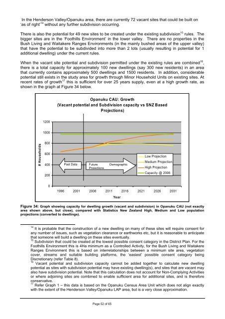
In the <strong>Henderson</strong> <strong>Valley</strong>/<strong>Opanuku</strong> area, there are currently 72 vacant sites that could be built on‘as of right’ 14 without any further subdivision occurring.There is also the potential for 49 new sites to be created under the existing subdivision 15 rules. Thebigger sites are in the ‘Foothills Environment’ in the lower valley. There are no properties in theBush Living and Waitakere Ranges Environments (in the mainly bushed areas of the upper valley)that have the potential to be subdivided into more than 2 lots (usually resulting in potential for 1additional dwelling) under the current rules.When the vacant site potential and subdivision permitted under the existing rules are combined 16 ,there is a total capacity for approximately 100 new dwellings (say 300 new residents) in an areathat currently contains approximately 500 dwellings and 1500 residents. In addition, considerablepotential still exists in the study area for growth through Minor Household Units on existing sites. Atrecent rates of growth 17 this is sufficient for over 25 years supply, even at a high growth rate, asshown in the graph at Figure 34 below.<strong>Opanuku</strong> CAU: Growth(Vacant potential and Subdivision capacity vs SNZ BasedProjections)12001000# Households800600400200Past Data Future DemographicProjectionsLow ProjectionMedium ProjectionHigh ProjectionCapacity @ 200601996 2001 2006 2011 2016 2021 2026 2031YearFigure 34: Graph showing capacity for dwelling growth (vacant and subdivision) in <strong>Opanuku</strong> CAU (not exactlyarea shown above, but close), compared with Statistics New Zealand High, Medium and Low populationprojections (converted to dwellings).14 It is probable that the construction of a new dwelling on many of these sites will require consent forany number of issues, such as vegetation clearance or earthworks etc, but it is reasonable to anticipatethat someone will build a dwelling on these sites eventually.15 Subdivision that could be created at the lowest possible consent category in the District <strong>Plan</strong>. For theFoothills Environment this is 4Ha minimum as a Controlled Activity, for the Bush Living and WaitakereRanges Environment this is based on interrelationships between a minimum site area, vegetationcover, streams and suitable building platforms, the ‘easiest’ possible consent category beingDiscretionary (refer Table 8).16 Vacant potential and subdivision capacity cannot be added together to calculate new dwellingpotential as sites with subdivision potential may have existing dwelling(s), and sites that are vacant mayalso have subdivision potential. Note that this calculation does not account for Non-Complying Activitiesor where adjoining sites are combined to enable sufficient area for additional sites, and is thereforeconservative.17 Refer Graph 1 – this data is based on the <strong>Opanuku</strong> Census <strong>Area</strong> Unit which does not align exactlywith the extent of the <strong>Henderson</strong> <strong>Valley</strong>/<strong>Opanuku</strong> LAP area, but is a very close approximation.Page 52 of 65
4.3. SUBDIVISION ISSUESIn <strong>Henderson</strong> <strong>Valley</strong>/<strong>Opanuku</strong>, there are significant pressures for subdivision over and above theDistrict <strong>Plan</strong> provisions - an almost inevitable feature at a rural/ urban interface in the <strong>Auckland</strong>region. In the neighbouring areas of Oratia and Swanson, additional subdivision (andaccompanying environmental enhancement measures) has been provided for through ruralstructure planning processes. However the Structure <strong>Plan</strong> Review and more recent Swansonexperience found that the costs associated with the development of a structure plan (considerablelitigation, technical assessments, and community division) outweighed the gains (limiteddevelopment potential or environmental enhancement) of undertaking the structure planningexercise, particularly in the absence of a strategic framework under which to consider structureplanning. The additional technical work undertaken in <strong>Henderson</strong> <strong>Valley</strong>/<strong>Opanuku</strong> has indicatedthat a Structure <strong>Plan</strong> is not necessary to accommodate future growth in a sustainable manner.The <strong>Local</strong> <strong>Area</strong> <strong>Plan</strong> process has highlighted a divergence of views on subdivision (refer to the<strong>Henderson</strong> <strong>Valley</strong> Community Consultation report). On one hand members of the wider communityhas indicated a strong desire to maintain the status quo by retaining a productive rural landscapewith larger rural properties, and to avoid the structure plan route that would provide for subdivisionbeyond the ‘4 hectare rule’ of the District <strong>Plan</strong>, as they had observed it in Oratia and Swanson.However, there are also strong views from individual landowners believing that more developmentis possible and desirable, ranging from urban type development through to a staged graduation ofdensity from urban, to large lot rural as one moves through the valley and away from the urbanarea.In addition to these diverse community views, the regulatory landscape has changed considerablyover the past few years, with the passing of the Waitakere Ranges Heritage <strong>Area</strong> Act 2008(WRHAA), amendments to the <strong>Auckland</strong> Regional Policy Statement (ARPS) through <strong>Plan</strong> Change6, and the Waitakere City Operative District <strong>Plan</strong> 2003 (Waitakere District <strong>Plan</strong>) via <strong>Plan</strong> Change16, and also through the recent notification of <strong>Plan</strong> Changes 35 and 36. (see also the WaitakereRanges Foothills Background report for more detailed analysis of relevant provisions).The WRHAA is clear that the heritage area (including the Foothills) will remain a rural place, thatsubdivision must not lead to urban sprawl, in seeking to protect heritage features the area has littlecapacity to absorb further subdivision, and heritage features (as outlined later in this report) must beprotected, restored and enhanced. Provisions of the WRHHA, including the Objectives andFeatures are proposed to be inserted directly into the District <strong>Plan</strong> via proposed <strong>Plan</strong> Change 35 18 .The ARPS identifies the upper part of <strong>Henderson</strong> <strong>Valley</strong>/<strong>Opanuku</strong> as areas of Significant NaturalHeritage Value and Significant Landscape quality and sensitivity and so should be managedaccordingly. Objective 2.6.1.1.19 and Policy 2.6.17 generally, and 2.6.17.1(e)(i) and 2.6.17.3 and 4especially, indicate that the Waitakere Ranges and their associated environmental values shall beprotected from inappropriate subdivision use and development and that low density residentialdevelopment (as anticipated by structure <strong>Plan</strong>ning in the Waitakere District <strong>Plan</strong>) shall be avoidedin rural areas unless additional capacity is required. The ARPS indicates that existing District <strong>Plan</strong>provisions provide 40 years capacity in the <strong>Auckland</strong> region, and analysis elsewhere in thisdocument shows that <strong>Henderson</strong> <strong>Valley</strong>/<strong>Opanuku</strong> has over 25 years of potential at current rates oftake up.Pursuant to s 73 of the RMA and s11 of the WRHHA Act, District <strong>Plan</strong>s must “give effect to“ boththe ARPS and the purpose and objectives of the WRHAA. Waitakere District <strong>Plan</strong> Change 16“gives effect” to these higher order documents through now operative Policy 0.11 by indicating thatfurther intensive settlement will not be provided in the Waitakere Ranges 19 . As noted above18 At the time of writing <strong>Plan</strong> Change 35 further submissions have just closed, and is at a very early stage ofthe process.19 This Policy has recently been the subject of a Consent Order and is now considered Operative.Page 53 of 65
existing structure plans and subdivision provisions across the foothills and ranges, and within<strong>Henderson</strong> <strong>Valley</strong> <strong>Opanuku</strong> provide enough capacity to accommodate growth needs for at leastanother 25 years. Within this statutory framework future subdivision options are narrowlyconstrained in <strong>Henderson</strong> <strong>Valley</strong>.As outlined earlier the District <strong>Plan</strong> provides for subdivision in the Foothills Environment to sites of4.0ha as a controlled activity (a minor consent not warranting public notification which also must begranted). To go beyond this standard (by providing for it in the District <strong>Plan</strong>) a structure planprocess 20 is anticipated in the District <strong>Plan</strong> or a non-complying activity (usually notified) is requiredon an individual site basis. A ‘structure plan’ approach for <strong>Henderson</strong> <strong>Valley</strong> is not anticipated,mandated, or considered necessary based on an assessment of the statutory framework andtechnical and landscape work completed to date. Non-complying subdivision to go beyond theexisting 4.0ha capacity is also not provided for, but neither is it ruled out in the existing District <strong>Plan</strong>standards 21 .Due to this stringent existing policy framework, the options for this LAP are limited to considering a4.0ha average density (so the overall yield or capacity for new dwellings is not increased) andgiving greater policy guidance to where non-complying activity consents may be more favourablyconsidered to occur in the future, subject to the achievement of specified aims.4.3.1. Large Properties<strong>Council</strong> has commissioned Stephen Brown Environments Ltd to compile a Landscape SensitivityStudy to help provide clarity on the various landscape features and sensitivities of areas of<strong>Henderson</strong> <strong>Valley</strong>/<strong>Opanuku</strong> to assist in determining an appropriate method for managingsubdivision in the future. This study has identified that, in the lower valley (zoned mostly as‘Foothills Environment’), many of the large properties with remaining subdivision potential are inareas of moderate to high landscape sensitivity (that is, are very visible and contribute significantlyto the existing landscape character). Most of these properties have productive rural activities, andcontain either denuded ecosystems requiring restoration, or high quality ecosystems requiring longterm protection and enhancement, or a combination of both.Once the large, currently open or productive areas, are ‘converted’ for residential lifestyle use,building density would increase and spaciousness, quietness, and the sense or essence of‘ruralness’ would be reduced. The 4 hectare rule can result in a ‘chequerboard’ pattern of evenlyspaced and sized lots and houses across the landscape, ‘drawing the eye’ to the even manmaderhythm in an otherwise naturalised rural landscape.On these sites, existing subdivision potential, if realised in accordance within a rigid application of ‘4hectare rule’, would not necessarily provide for the protection, enhancement and/or maintenance ofidentified heritage features, other than incidentally, for example through stormwater neutralityplanting, and would most likely result in an overall decline in landscape quality for the whole <strong>Valley</strong>.A more flexible approach to lot size (but not total lot yield), access and building spacing may bepreferable, taking into account the individual characteristics of each site in the context of the wider<strong>Valley</strong>. Given the small number of sites in the <strong>Valley</strong> with significant subdivision potential under the4 hectare rule 22 , the landscape assessment indicates that a site specific approach, such as the20 See Policy 11.29, Waitakere District <strong>Plan</strong>21 As a non-complying activity, an application may still be made, but as no ‘rules’ provide guidance, it mayonly be granted if the effects are less than minor or, is not contrary to the objectives and policies of therelevant <strong>Plan</strong>(s) - see s104D Resource Management Act 1991. Compare with a ‘prohibited activity’ for whichno application may be made.22 There are only four large sites in the valley that, under the 4 hectare rule, have at least 5 new sites, with thelargest site having the potential for 24 sites at just under 100Ha. There are a number of other sites across the<strong>Valley</strong> with subdivision potential, but they can be managed by the existing provisions of the District <strong>Plan</strong> asthey have only 1 additional site each. Refer Figure 32Page 54 of 65
Large Property Management <strong>Area</strong> 23 (LPMA) is the preferred option for larger sites (refer Figure 35)based on an application of a 4.0ha average site size with a recommended minimum 2.0ha site size.Figure 35: Proposed large Property Management <strong>Area</strong>sThis site specific approach will allow the various heritage features on the sites to be better managedaccording to their differing importance as assessed on a site by site basis. For example visuallandscape issues will be more relevant on sites that are more visible and have a higher sensitivity tochange such as the Lockington and Lyon site, where retention of productive capacity and existingrural activities, or enhancement of riparian vegetation may be a key concern on other sites. A moredetailed description of the Large properties follows:LPMA 1.<strong>Valley</strong> View:55 Grassmere Road/<strong>Opanuku</strong> Rd. Currently has subdivision potential for 5 new sites, with 1dwelling. There are a total of 8 separate parcels of land including non-contiguous sites, some ofwhich are amalgamated together (requiring a ‘subdivision’ to separate), some are simply vacanttitles.This property forms the pastoral and vegetated western backdrop to Grassmere Road and is highlyvisible. The site has been assessed in the Landscape Study as being of Elevated Sensitivity to VeryHigh Sensitivity.23 Large Property Management <strong>Area</strong>s are existing provisions in the Waitakere District <strong>Plan</strong>, however anysimilar approach could be used. The LPMA policies and explanations implies sites would be in the WaitakereRanges Environment and over 30Ha, and so some modification of these requirements may also beappropriate.Page 55 of 65
It is primarily a residential site, but the owners do operate a Riding School in the summer months onthe property, as well as dry stock grazing. Some of the bush cover is fenced, and some is undergrazed, mainly to keep weeds down, which are an ongoing problem in some areas of the site.Features to protect, restore and enhance include:• the visual quality of the views from the lower valley, and particularly from adjacentGrassmere Road, requiring careful dwelling placement; and• the quality of the native vegetative cover, by actively managing weeds and pests, andhen excluding stock from under-grazing.• The bush areas are identified in the District <strong>Plan</strong> as being within the Outstanding NaturalLandscape: Ranges, the bushline more or less defining the eastern extent of thisoverlayThe open pastoral areas should however be maintained as open areas and preferably used (i.e.grazed) as far as practicable unless screening or mitigation planting is required.Provision should also be made to de-amalgamate (i.e. subdivide) from the main title they arecurrently amalgamated with, the 3 non-contiguous parcels located to the south of the property nearthe end of Grassmere Road to allow for a maximum of 2 new buildable sites.Figure 36: View from existingdwelling overlooking GrassmereRd towards CityFigure 37: The <strong>Valley</strong> ViewRiding School tack shed – alocal landmarkPage 56 of 65
LPMA 2.GoldenWest Orchards (HV Block):<strong>Henderson</strong> <strong>Valley</strong> Road/Gum Road. Has potential for 6 new sites on 2 adjoining titles with noexisting dwellings (i.e. vacant).This property is generally bare of any significant native vegetation and is flat to rolling. It is almostfully planted in a number of varieties of apple trees, with implement sheds and access roads. Anumber of shelterbelts cross the property enclosing the orchard blocks.The <strong>Henderson</strong> <strong>Valley</strong> Road frontage of the site is assessed as being of Limited Sensitivity from alandscape perspective due to the existence of the shelterbelts screening the site from wider view,with the rear (towards Gum Rd) being of Elevated Sensitivity, because of its increasing elevation,and overlooking from higher slopes surrounding.The shelterbelts and at least some orcharding trees should be kept, to enable the visualscreening/absorption of any new development, as well as retain a semblance of rural activities. TheParemuka Stream running though the property would benefit from weed control and further nativerevegetation on its margins to supplement that already underway, particularly in the steeper gullyareas.The Foothills Walkway concept also identifies a connection through the property (following theParemuka Stream) from Gum Road to <strong>Henderson</strong> <strong>Valley</strong> Road.Figures 38-41: Various Images taken on and looking into the property: From top left, Clockwise:Looking towards Gum Road from near Parekura Stream; Level area in the centre of the propertylooking towards Gum Road; From Gum Road looking down the orchard rows to the <strong>Opanuku</strong>Stream embankment; Orchard rows in one of the production blocks.Page 57 of 65
LPMA 3.Lockington and Lyon:10 Gum Road/Forest Hill Rd. 2 large, mostly pastoral blocks of just under 100Ha, with potential for24 sites @ 4Ha, with no existing dwellings (i.e. vacant).This site is subject to a District <strong>Plan</strong> appeal (Reference: RMA835/98) predating the WRHHA 2008,initially seeking a change to the Structure <strong>Plan</strong> rules to allow the provisions to apply to areas lessthan a whole Catchment. The scope of this appeal has since been narrowed to a site specificreference seeking 2Ha subdivision (enabling potentially 50 new sites). Accordingly this site isidentified both because an alternative approach is not only preferable, and because the matter isbefore Environment Court.Landscape analysis has identified that the broad, bald pastoral hills which dominate two separateviewing catchments are highly sensitive to change. It should also be noted that this key feature isnot presently identified in the District <strong>Plan</strong> as a Sensitive Ridgeline. A 4Ha or 2Ha minimum site sizeapproach would lead to a proliferation of highly visible buildings, mostly likely on or near theridgeline for views, access off the existing farm tracks and the slightly more level building platformsavailable on the hill crests. A number of tributaries of the <strong>Opanuku</strong> Stream (the McCleod andAnamata Streams) flow through the site but are denuded of riparian vegetation and are accessibleto the dry stock run on the property.The Foothills Walkway concept identifies as perhaps the key linkage in the concept, a connectionthrough this property between Forest Hill and Gum Roads, linking the Oratia/Waiatarua areas with<strong>Henderson</strong> <strong>Valley</strong>/<strong>Opanuku</strong> and Swanson.A cluster approach to any subdivision on this site would be preferable to keep building sites off thehill crests (located in the lower or less visible parts of the site), combined with riparian enhancementplanting and stock exclusion, landscape planting and ideally enabling the pastoral activity tocontinue across the upper slopes. <strong>Plan</strong>ting of a row of trees across the crest of the hill may alsoserve to better separate viewing catchments and reduce impacts of buildings, building sites andaccess on or close to the ridgeline.Due to the sites current status as under appeal, the potential for an agreement to be reached byway of consent order exists, rather than undertaking a <strong>Plan</strong> Change, as will be required for theother 3 Large sites.The LAPs background work will be used by the <strong>Council</strong> and other parties to inform the eventualsettlement of the appeal, including more detailed site specific investigations.Figure 42 (Right): Site as Viewed fromGum RoadFigure 43 (Below): Looking over thesite from Forest Hill Road.Page 58 of 65
LPMA 4.Pleasant <strong>Valley</strong><strong>Henderson</strong> <strong>Valley</strong> Rd, a number of parcels covering 54Ha, with existing potential for 9 sites @ 4Ha.The site includes the Pleasant <strong>Valley</strong> Winery building and a number of pastoral and vineyardblocks, as well as recently subdivided 4 Ha blocks which remain in family ownership. This is theremaining landholding of the once extensive Pleasant <strong>Valley</strong> Wines landholdings; originallypurchased by Stephan Yelas in the late 19 th century and initially used for gumdigging. The winerywas then established some years later in 1902 and is now the oldest continually operating inWaitakere. The winery is still run by the Yelas family, and is the third largest wine bottler by volumein the <strong>Auckland</strong> Region, contract bottling for other wineries using grapes from all over New Zealand,and the Foothills, including the famous home block Pinotage.The site is rolling and generally denuded of native and riparian vegetation on the Vela and AnamataStreams that run though the property and form its southern boundary, though there are some largeareas of reverting weedy bush particularly towards the rear of the property. There are a number oflarge specimen and ‘firewood’ trees over the property, and numerous shelterbelts. The sites layoutis generally ‘humped’, with flat areas close to the road rising to a low hill and then falling away to theAnamata on the rear boundary, meaning a large proportion of the site is visible from <strong>Henderson</strong><strong>Valley</strong> Road and the remainder viewed from the more distant Forest Hill Road.Retention of the productive potential of the site including the winery buildings and vineyards is a keyfeature that should be protected and enhanced, along with riparian revegetation and weedmanagement. Retention of the shelterbelts and specimen trees as well as vineyards would alsoassist in absorbing any new development into its relatively open viticultural/rural setting.The Foothills Walkway Concept notes the potential for a walking connection through the site(dependent of a further connection from Forest hill road to the site boundary), though a number ofoptions will be further investigated through a future feasibility study.A future subdivision arrangement enabling the retention of the productive potential and heritageviticulture setting is preferred, such as smaller residential blocks (or building sites with a sharedownership arrangement of the central vineyard area) clustered around the edges, with a largeparent block or similar. Ongoing management and productive use of the large central vineyard &winery complex would need to be confirmed with the owners, and any chosen lot arrangement willbe subject to further discussion.Other sites with existing subdivision potential:There are a number of sites with limited potential for further subdivision (properties with potential for1 or 2 new sites, outside of the identified LPMA’s) in <strong>Henderson</strong> <strong>Valley</strong>/<strong>Opanuku</strong>. The futuresubdivision of these sites can be effectively managed by utilising the existing District <strong>Plan</strong>provisions.It is the large sites with multiple new sites and a range of heritage features across large areas thatrequire a more flexible and responsive approach than that contemplated by the existing District <strong>Plan</strong>rules that apply.Implementation:The District <strong>Plan</strong> already contains the LPMA provision, which to date has been applied to four largeproperties in the city 24 under single ownership. Under this approach, each property’s unique issuesand opportunities are considered, in order to provide for improved outcomes. For example, the“Waiatarua Parklands” LPMA (now Bendalls Lane) focussed on provision of a more sustainablecluster type subdivision pattern with a shared effluent disposal system, that would not have beenpossible under the general rules applying to that site.24 Of the four properties where the LPMA approach has been applied, one is at Waiatarua Parklands (nowBendalls Lane), and the remaining three on large extended family holdings at Bethells Beach/Te Henga.Page 59 of 65
Application of the LPMA approach would need to be undertaken via District <strong>Plan</strong> Change (asanticipated in the relevant LPMA policy) apart from on the Lockington and Lyon property whichcould be implemented via the existing District <strong>Plan</strong> appeal applying to this site, which also predatesthe WRHAA.Rather than promoting a Waitakere District <strong>Plan</strong> change immediately following the LAP (in additionto the required detailed technical work and focussed consultation and discussions with the relevantlandowners) for the remaining three large properties it is recommended that this change inapproach be recommended to the <strong>Auckland</strong> <strong>Council</strong> for consideration as they move towardsdeveloping a Unitary <strong>Plan</strong> for the wider <strong>Auckland</strong> area. This will require a similar amount of workand discussion, but would remove an unrealistic 1 November 2010 timeframe. In the interim theLAP could be utilised to guide any non-complying subdivision applications on the identified LPMA’swithin the parameters outlined above.4.3.2. Rural/Urban Interface Management <strong>Area</strong>sThe Landscape Sensitivity report also identified areas of ‘Low Sensitivity’ across a number of sitesclose to the urban edge that are considered less sensitive to change (refer Figure 44). Unlike theLPMA’s identified above the Low Sensitivity area covers sites that are typically smaller (all are lessthan 8Ha) and the area shown is under multiple ownership by a number of landowners.This contiguous area of Low Sensitivity has been identified as such in the Landscape Study, mainlydue to the influence and visual relationship of the adjacent urban area and its recent development,or the presence of existing development, on the rural character of these areas.Not all areas identified as being of Low Sensitivity have been further identified as Rural/UrbanInterface Management <strong>Area</strong>s. The area to the north of <strong>Henderson</strong> <strong>Valley</strong> Road and south of the<strong>Opanuku</strong> Stream has been excluded due to the extent of the 1:100 year 25 floodplain from the<strong>Opanuku</strong> Stream, and the level of existing development. The area opposite, on the south side of<strong>Henderson</strong> <strong>Valley</strong> Road has not been included as the existing level of development anddevelopment potential (including subdivision potential and a number of existing non-residentialactivities) is such that further development would be detrimental to the remaining rural character ofthe <strong>Valley</strong> as a whole and could lead to a ribbon of development creeping into the <strong>Valley</strong> propernegating the sense of transition currently experienced travelling along <strong>Henderson</strong> <strong>Valley</strong> Road intothe <strong>Valley</strong>.However, the remaining areas of Low Sensitivity have been identified as Rural/Urban InterfaceManagement <strong>Area</strong>s 26 , which are considered areas that could accommodate development beyondwhat the 4Ha rule would allow, without impacting on rural character of the <strong>Valley</strong> or contributing tourban sprawl. The maximum density/minimum average site size considered appropriate in theseareas based on work undertaken to date, is recommended to be no less than 2Ha 27 .25 The actual term is 1% Annual Exceedance Probability: this makes clear that the measure indicates thatthere is a 1% (or 1/100) chance of a flood of this magnitude (or greater) occurring in any given year, ratherthan the implication (of the ‘1 in 100 year flood’ term), that the flood will occur only once every 100 th year. Withclimate change impacts expected to increase the intensity and frequency of storm events, the currentlymodelled 1% AEP flood event is expected to increase in probability and future models (and experience) of the1% AEP event are likely to be of greater magnitude.26 This term is considered to be a working title and suggestions are welcomed.27 Lot size is a simple and effective (and easily understood/calculated) method of managing land use changein a broad way. However what is more important in the long term maintenance of rural character is theplacement of buildings and their relationship to the surrounding elements of the landscape (as even 4Ha rulewill not necessarily maintain rural character). Any consideration of a plan change, or application for resourceconsent would need to work from the first principle of ‘where should the buildings best be located’ with lotscreated to enable that layout, rather than rigid use of a minimum lot size with buildings ending up located inthe middle of the site.Page 60 of 65