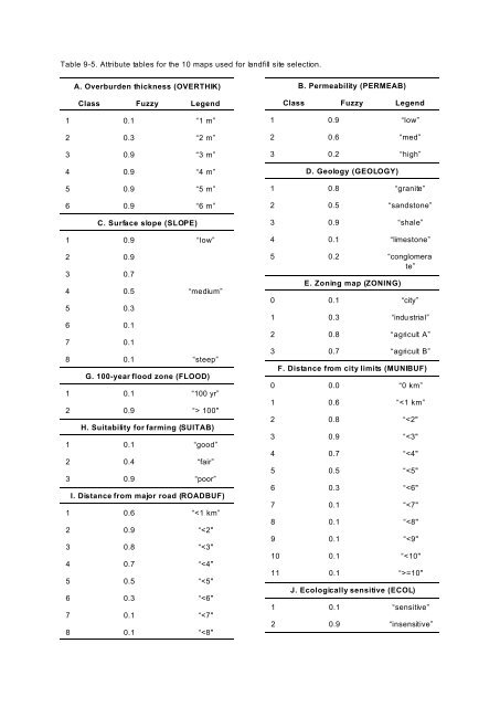
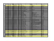
Table 9-5. Attribute tables for the 10 maps used for landfill site selection.A. Overburden thickness (OVERTHIK)Class <strong>Fuzzy</strong> Legend1 0.1 “1 m”2 0.3 “2 m”3 0.9 “3 m”4 0.9 “4 m”5 0.9 “5 m”6 0.9 “6 m”C. Surface slope (SLOPE)1 0.9 “low”2 0.93 0.74 0.5 “medium”5 0.36 0.17 0.18 0.1 “steep”G. 100-year flood zone (FLOOD)1 0.1 “100 yr”2 0.9 “> 100"H. Suitability for farming (SUITAB)1 0.1 “good”2 0.4 “fair”3 0.9 “poor”I. Distance from major road (ROADBUF)1 0.6 “
Combining <strong>Fuzzy</strong> Membership FunctionsGiven two or more maps with fuzzy membership functions for the same set, a variety of operators can beemployed to combine the membership values together. The book by Zimmermann (1985), for example,discusses a variety of combination rules. An et al. (1991) discuss five operators that were found to be useful forcombining exploration datasets, namely the fuzzy AND, fuzzy OR, fuzzy algebraic product, fuzzy algebraic sumand fuzzy gamma operator. T hese operators are briefly reviewed here.<strong>Fuzzy</strong> ANDThis is equivalent to a Boolean AND (logical intersection) operation on classical set values of (1,0). It is definedaswhere : A is the membership valu e for map A at a particular location, : B , is the value for map B, and so on. Ofcourse, the fuzzy memberships must all be with respect to the same proposition. Suppose that at some locationthe membership value for map A is 0.75 and for map B is 0.5, then the membership for the combination usingfuzzy AND is 0.5. It can readily be seen that the effect of this rule is to make the output map be controlled bythe smallest fuzzy membership value occurring at each location. Like the Boolean AND, fuzzy AND results in aconservative estimate of set membership, with a tendency to prod uce small values. The AND operation isappropriate where two or more pieces of evidence for a hypothesis must be present together for the hypothesis tobe true.<strong>Fuzzy</strong> OROn the other hand, the fuzzy OR is the like the Boolean OR (logical union) in that the output membership valuesare controlled by the maximum values of any of the input maps, for any particular location. The fuzzy OR isdefined as(9-4)(9-5)Using this operator, the combined membership value at a location (=suitability for landfill etc) is limited only bythe most suitable of the evidence maps. This is not a particularly desirable operator for the landfill case, butmight in some circumstances be reasonable for mineral potential mapping, where favourable indicators ofmineraliz ation are rare and the p resen ce of any po sitive evid ence may b e sufficien t to su ggest favou rability.Note that in using either the fuzzy AND or fuzzy OR, a fuzzy membership of a single piece of evidence controlsthe output value. On the other hand, the following operators combine the effects of two or more pieces ofeviden ce in a "blended" result, so th at each data source has som e effect on the output.