Bobcat Ridge Management Plan - City of Fort Collins, CO
Bobcat Ridge Management Plan - City of Fort Collins, CO
Bobcat Ridge Management Plan - City of Fort Collins, CO

Create successful ePaper yourself
Turn your PDF publications into a flip-book with our unique Google optimized e-Paper software.
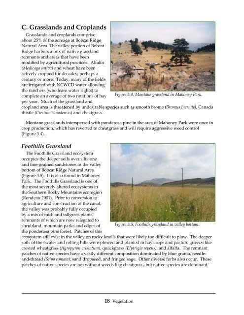
C. Grasslands and Croplands<br />
Grasslands and croplands comprise<br />
about 25% <strong>of</strong> the acreage at <strong>Bobcat</strong> <strong>Ridge</strong><br />
Natural Area. The valley portion <strong>of</strong> <strong>Bobcat</strong><br />
<strong>Ridge</strong> harbors a mix <strong>of</strong> native grassland<br />
remnants and areas that have been<br />
modified by agricultural practices. Alfalfa<br />
(Medicago sativa) and wheat have been<br />
actively cropped for decades; perhaps a<br />
century or more. Today, many <strong>of</strong> the fields<br />
are irrigated with NCWCD water allowing<br />
the ranchers (who lease water rights) to<br />
complete an average <strong>of</strong> two rotations <strong>of</strong> hay Figure 3.4. Montane grassland in Mahoney Park.<br />
per year. Much <strong>of</strong> the grassland and<br />
cropland area is threatened by undesirable species such as smooth brome (Bromus inermis), Canada<br />
thistle (Cirsium canadensis) and cheatgrass.<br />
Montane grasslands interspersed with ponderosa pine in the area <strong>of</strong> Mahoney Park were once in<br />
crop production, which has reverted to cheatgrass and will require aggressive weed control<br />
(Figure 3.4).<br />
Foothills Grassland<br />
The Foothills Grassland ecosystem<br />
occupies the deeper soils over siltstone<br />
and fine-grained sandstones in the valley<br />
bottom <strong>of</strong> <strong>Bobcat</strong> <strong>Ridge</strong> Natural Area<br />
(Figure 3.5). It is also found in Mahoney<br />
Park. The Foothills Grassland is one <strong>of</strong><br />
the most severely altered ecosystems in<br />
the Southern Rocky Mountains ecoregion<br />
(Rondeau 2001). Prior to conversion to<br />
agriculture and construction <strong>of</strong> the canal,<br />
the valley was probably fully occupied<br />
by a mix <strong>of</strong> mid- and tallgrass plants,<br />
remnants <strong>of</strong> which are now relegated to<br />
shrubland, mountain parks and edges <strong>of</strong> Figure 3.5. Foothills grassland in valley bottom.<br />
the ponderosa pine forest. Patches <strong>of</strong> this<br />
ecosystem still exist in the valley on rocky knolls that were likely too difficult to plow. The deeper<br />
soils <strong>of</strong> the swales and rolling hills were plowed and planted in hay crops and pasture grasses like<br />
crested wheatgrass (Agropyron cristatum), quackgrass (Elytrigia repens), and alfalfa. The remnant<br />
patches <strong>of</strong> native species have a vastly different composition dominated by blue grama, needleand-thread<br />
(Stipa comata), sand dropseed, and fringed sage. Other diverse forbs also occur. These<br />
patches <strong>of</strong> native species are not without weeds like cheatgrass, but native species are dominant.<br />
18 Vegetation
![Fort Collins Tree ID Study Guide [Compatibility Mode]](https://img.yumpu.com/20764911/1/190x135/fort-collins-tree-id-study-guide-compatibility-mode.jpg?quality=85)