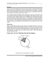
Bobcat Ridge Management Plan - City of Fort Collins, CO
Bobcat Ridge Management Plan - City of Fort Collins, CO
Bobcat Ridge Management Plan - City of Fort Collins, CO

You also want an ePaper? Increase the reach of your titles
YUMPU automatically turns print PDFs into web optimized ePapers that Google loves.
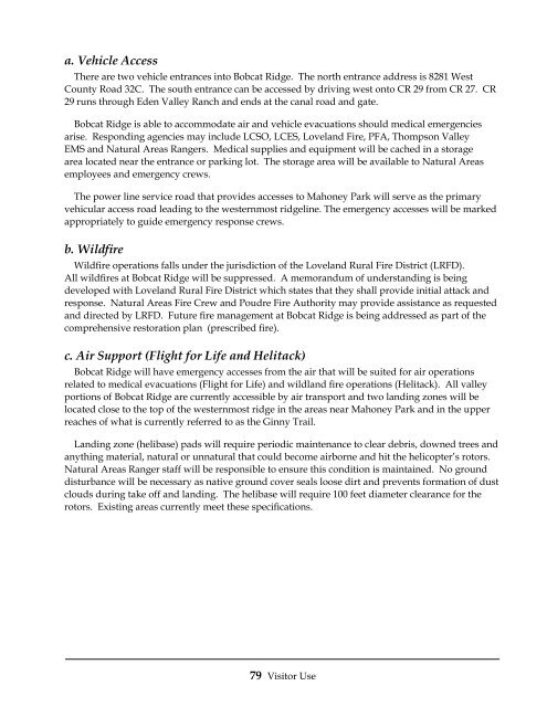
a. Vehicle Access<br />
There are two vehicle entrances into <strong>Bobcat</strong> <strong>Ridge</strong>. The north entrance address is 8281 West<br />
County Road 32C. The south entrance can be accessed by driving west onto CR 29 from CR 27. CR<br />
29 runs through Eden Valley Ranch and ends at the canal road and gate.<br />
<strong>Bobcat</strong> <strong>Ridge</strong> is able to accommodate air and vehicle evacuations should medical emergencies<br />
arise. Responding agencies may include LCSO, LCES, Loveland Fire, PFA, Thompson Valley<br />
EMS and Natural Areas Rangers. Medical supplies and equipment will be cached in a storage<br />
area located near the entrance or parking lot. The storage area will be available to Natural Areas<br />
employees and emergency crews.<br />
The power line service road that provides accesses to Mahoney Park will serve as the primary<br />
vehicular access road leading to the westernmost ridgeline. The emergency accesses will be marked<br />
appropriately to guide emergency response crews.<br />
b. Wildfire<br />
Wildfire operations falls under the jurisdiction <strong>of</strong> the Loveland Rural Fire District (LRFD).<br />
All wildfires at <strong>Bobcat</strong> <strong>Ridge</strong> will be suppressed. A memorandum <strong>of</strong> understanding is being<br />
developed with Loveland Rural Fire District which states that they shall provide initial attack and<br />
response. Natural Areas Fire Crew and Poudre Fire Authority may provide assistance as requested<br />
and directed by LRFD. Future fire management at <strong>Bobcat</strong> <strong>Ridge</strong> is being addressed as part <strong>of</strong> the<br />
comprehensive restoration plan (prescribed fire).<br />
c. Air Support (Flight for Life and Helitack)<br />
<strong>Bobcat</strong> <strong>Ridge</strong> will have emergency accesses from the air that will be suited for air operations<br />
related to medical evacuations (Flight for Life) and wildland fire operations (Helitack). All valley<br />
portions <strong>of</strong> <strong>Bobcat</strong> <strong>Ridge</strong> are currently accessible by air transport and two landing zones will be<br />
located close to the top <strong>of</strong> the westernmost ridge in the areas near Mahoney Park and in the upper<br />
reaches <strong>of</strong> what is currently referred to as the Ginny Trail.<br />
Landing zone (helibase) pads will require periodic maintenance to clear debris, downed trees and<br />
anything material, natural or unnatural that could become airborne and hit the helicopter’s rotors.<br />
Natural Areas Ranger staff will be responsible to ensure this condition is maintained. No ground<br />
disturbance will be necessary as native ground cover seals loose dirt and prevents formation <strong>of</strong> dust<br />
clouds during take <strong>of</strong>f and landing. The helibase will require 100 feet diameter clearance for the<br />
rotors. Existing areas currently meet these specifications.<br />
79 Visitor Use


![Fort Collins Tree ID Study Guide [Compatibility Mode]](https://img.yumpu.com/20764911/1/190x135/fort-collins-tree-id-study-guide-compatibility-mode.jpg?quality=85)