iPhone, iPad, iPod Touch User Guide for ArcGIS Mobile App
iPhone, iPad, iPod Touch User Guide for ArcGIS Mobile App
iPhone, iPad, iPod Touch User Guide for ArcGIS Mobile App

Create successful ePaper yourself
Turn your PDF publications into a flip-book with our unique Google optimized e-Paper software.
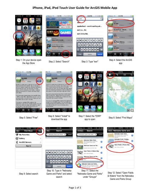
<strong>iPhone</strong>, <strong>iPad</strong>, <strong>iPod</strong> <strong>Touch</strong> <strong>User</strong> <strong>Guide</strong> <strong>for</strong> <strong>ArcGIS</strong> <strong>Mobile</strong> <strong>App</strong>Step 1: On your device openthe <strong>App</strong> StoreStep 2: Select "Search"Step 3: Type "esri"Step 4: Select the <strong>ArcGIS</strong>appStep 5: Select "Free"Step 6: Select "Install" todownload the appStep 7: Select the "ESRI"app to openStep 8: Select "Find Maps"Step 9: Select searchStep 10: Type in "NebraskaGame and Parks" and selectsearchStep 11: Select the"Nebraska Game and Parks"under "Groups"Step 12: Select "Open Fields& Waters" from the NebraskaGame and Parks GroupPage 1 of 3
<strong>iPhone</strong>, <strong>iPad</strong>, <strong>iPod</strong> <strong>Touch</strong> <strong>User</strong> <strong>Guide</strong> <strong>for</strong> <strong>ArcGIS</strong> <strong>Mobile</strong> <strong>App</strong>Step 13: Zoom in to afeature on the mapStep 14: Tap on a propertyStep 15: Tap on the arrow onthe property labelStep 16: View the propertyin<strong>for</strong>mation and then go backto the mapStep 17: Tap on the "i"Step 18: View the LegendStep 19: Select the "Content"tab and tap on the basemaparrowStep 20: Choose the"Topographic" basemap andview the mapStep 21: Zoom to view aproperty with the topobasemapStep: 22: Go back to Step 16and tap the "basemap"Step 23: Select the Imagerywith LabelsStep 24: Zoom to a propertyto view with aerial imageryPage 2 of 3
<strong>iPhone</strong>, <strong>iPad</strong>, <strong>iPod</strong> <strong>Touch</strong> <strong>User</strong> <strong>Guide</strong> <strong>for</strong> <strong>ArcGIS</strong> <strong>Mobile</strong> <strong>App</strong>Step 25: Go back to Step 16and select the "Detail" tabStep 26: View the details ofthe OFW MapStep 27: Select the "tools"symbolStep 28: Use the measuretools and click "Map" toreturn to the map imageStep 29 Select "Find Maps"Step 30: If you have anarcgis.com Global Accountyou can sign inStep 31: Signing in allowsyou to Bookmark locationsand save maps as FavoritesGo back to "Search" and inGroups Choose "NebraskaState Parks"Zoom to a State Park featureon the mapGo back to "Search" and inGroups Choose "NebraskaPublic Fishing"Zoom to a Public Fishingfeature on the mapPage 3 of 3