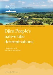
Biodiveristy_State of Environment report - Mission Beach Cassowaries
Biodiveristy_State of Environment report - Mission Beach Cassowaries
Biodiveristy_State of Environment report - Mission Beach Cassowaries
- No tags were found...

You also want an ePaper? Increase the reach of your titles
YUMPU automatically turns print PDFs into web optimized ePapers that Google loves.
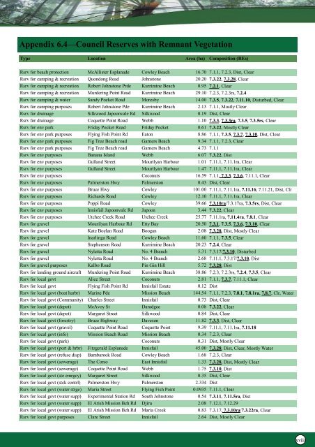
Appendix 6.4—Council Reserves with Remnant VegetationType Location Area (ha) Composition (REs)Rsrv for beach protection McAllister Esplanade Cowley <strong>Beach</strong> 16.70 7.1.1, 7.2.3, Dist, ClearRsrv for camping & recreation Quondong Road Johnstone 20.20 7.3.22, 7.3.28, ClearRsrv for camping & recreation Robert Johnstone Prde Kurrimine <strong>Beach</strong> 0.95 7.2.1, ClearRsrv for camping & recreation Murdering Point Road Kurrimine <strong>Beach</strong> 29.10 7.2.3, 7.2.3rs, 7.2.4Rsrv for camping & water Sandy Pocket Road Moresby 14.00 7.3.5, 7.3.22, 7.11.10, Disturbed, ClearRsrv for camping purposes Robert Johnstone Pde Kurrimine <strong>Beach</strong> 2.13 7.1.1, Mostly ClearRsrv for drainage Silkwood Japoonvale Rd Silkwood 0.19 Dist, ClearRsrv for drainage Coquette Point Road Webb 1.10 7.3.3, 7.3.3ra, 7.3.5, 7.3.5rs, ClearRsrv for env park Friday Pocket Road Friday Pocket 0.61 7.3.22, Mostly ClearRsrv for env park purposes Flying Fish Point Rd Eaton 8.86 7.1.1, 7.3.5, 7.3.7, 7.3.10, Dist, ClearRsrv for env park purposes Fig Tree <strong>Beach</strong> road Garners <strong>Beach</strong> 9.34 7.1.1, 7.2.3, ClearRsrv for env park purposes Fig Tree <strong>Beach</strong> road Garners <strong>Beach</strong> 4.73 7.1.1Rsrv for env purposes Banana Island Webb 6.07 7.3.22, DistRsrv for env purposes Gulland Street Mourilyan Harbour 1.01 7.11.1, 7.11.1ra, ClearRsrv for env purposes Gulland Street Mourilyan Harbour 1.47 7.11.1, 7.11.1ra, ClearRsrv for env purposes Coconuts 16.59 7.1.1, 7.3.3, 7.3.6, 7.11.1, ClearRsrv for env purposes Palmerston Hwy Palmerston 0.43 Dist, ClearRsrv for env purposes Bruce Hwy Cowley 101.00 7.11.1, 7.11.1ra, 7.11.16, 7.11.21, Dist, ClrRsrv for env purposes Richards Road Cowley 12.10 7.11.1, 7.11.1ra, ClearRsrv for env purposes Poppi Road Cowley 39.66 7.3.10ra/7.3.17ra, 7.3.5rs, Dist, ClearRsrv for env purposes Innisfail Japoonvale Rd Japoon 3.44 7.3.22, ClearRsrv for env purposes Utchee Creek Road Utchee Creek 25.77 7.11.1ra, 7.11.4ra, 7.8.1, ClearRsrv for gravel Mourilyan Harbour Rd Etty Bay 20.50 7.3.1, 7.3.5, 7.3.6, 7.3.10, ClearRsrv for gravel Kate Boylan Road Boogan 2.08 7.3.28, Dist, Mostly ClearRsrv for gravel Inarlinga Road Cowley <strong>Beach</strong> 11.60 7.1.1, 7.3.5, ClearRsrv for gravel Stephenson Road Kurrimine <strong>Beach</strong> 20.23 7.2.4, ClearRsrv for gravel Nyletta Road No. 4 Branch 5.31 7.3.17/7.3.10, DisturbedRsrv for gravel Nyletta Road No. 4 Branch 2.68 7.11.1, 7.3.17/7.3.10, DistRsrv for gravel purposes Kalbo Road Pin Gin Hill 5.72 7.3.28, DistRsrv for landing ground aircraft Murdering Point Road Kurrimine <strong>Beach</strong> 38.86 7.2.3, 7.2.3rs, 7.2.4, 7.3.5, ClearRsrv for local govt Alice Street Coconuts 2.81 7.1.1, 7.3.7, 7.11.1, ClearRsrv for local govt Flying Fish Point Rd Innisfail Estate 0.12 DistRsrv for local govt (boat harbr) Marine Pde <strong>Mission</strong> <strong>Beach</strong> 144.54 7.1.1, 7.2.3, 7.8.1, 7.8.1ra, 7.8.7, Clr, WaterRsrv for local govt (Community) Charles Street Innisfail 0.73 Dist, ClearRsrv for local govt (depot) McAvoy St Daradgee 0.08 7.3.22, ClearRsrv for local govt (depot) Margaret Street Silkwood 0.84 Dist, ClearRsrv for local govt (forestry) Bruce Highway Daveson 11.82 7.3.3, Dist, ClearRsrv for local govt (gravel) Coquette Point Road Coquette Point 9.39 7.11.1, 7.11.1ra, 7.11.18Rsrv for local govt (info) <strong>Mission</strong> <strong>Beach</strong> Road <strong>Mission</strong> <strong>Beach</strong> 0.34 7.2.3, ClearRsrv for local govt (park) Coconuts 0.31 Dist, Mostly ClearRsrv for local govt (port & hrbr) Fitzgerald Esplanade Innisfail 45.00 7.3.28, Dist, Clear, Mostly WaterRsrv for local govt (refuse disp) Bambarook Road Cowley <strong>Beach</strong> 1.68 7.2.3, ClearRsrv for local govt (sewerage) The Corso East Innisfail 1.33 7.3.28, Dist, Mostly ClearRsrv for local govt (sewerage) Coquette Point Road Webb 1.75 7.3.10, DistRsrv for local govt (ste emrgcy) Margaret Street Silkwood 0.35 Dist, ClearRsrv for local govt (stck contrl) Palmerston Hwy Palmerston 2.334 DistRsrv for local govt (water strge) Maria Street Flying Fish Point 0.0935 7.11.1, ClearRsrv for local govt (water supp) Experimental Station Rd South Johnstone 0.54 7.3.11, 7.11.5ra, DistRsrv for local govt (water supp) El Arish <strong>Mission</strong> Bch Rd Djiru 2.08 7.12.1, 7.12.29Rsrv for local govt (water supp) El Arish <strong>Mission</strong> Bch Rd Maria Creek 0.83 7.3.17, 7.3.10ra/7.3.22ra, ClearRsrv for local govt purposes Clare Street Innisfail 2.64 Dist, Mostly Clearxviii