PDF - Digital Imaging and Remote Sensing Laboratory - Rochester ...
PDF - Digital Imaging and Remote Sensing Laboratory - Rochester ...
PDF - Digital Imaging and Remote Sensing Laboratory - Rochester ...

Create successful ePaper yourself
Turn your PDF publications into a flip-book with our unique Google optimized e-Paper software.
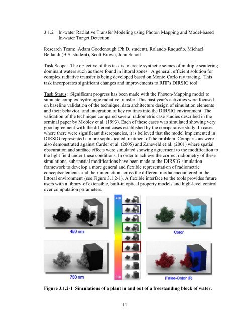
3.1.2 In-water Radiative Transfer Modeling using Photon Mapping <strong>and</strong> Model-basedIn-water Target DetectionResearch Team: Adam Goodenough (Ph.D. student), Rol<strong>and</strong>o Raqueño, MichaelBell<strong>and</strong>i (B.S. student), Scott Brown, John SchottTask Scope: The objective of this task is to create synthetic scenes of multiple scatteringdominant waters such as those found in littoral zones. A general, efficient solution forcomplex radiative transfer is being developed based on Monte Carlo ray tracing. Thistask incorporates significant changes <strong>and</strong> improvements to RIT’s DIRSIG tool.Task Status: Significant progress has been made with the Photon-Mapping model tosimulate complex hydrologic radiative transfer. This past year's activities were focusedon baseline validation of the technique, data architecture design of simulation elements<strong>and</strong> their behavior, <strong>and</strong> integration of key routines into the DIRSIG environment. Thevalidation of the technique compared several radiometric case studies described in theseminal paper by Mobley et al. (1993). Each of these cases was simulated showing verygood agreement with the different cases established by the comparative study. In caseswhere there were significant discrepancies, it is believed that the model implemented inDIRSIG represented a more sophisticated treatment of the problem. Comparisons werealso demonstrated against Carder et al. (2005) <strong>and</strong> Zaneveld et al. (2001) where spatialobscuration <strong>and</strong> surface effects were simulated showing agreement to the modification tothe light field under these conditions. In order to achieve the correct radiometry of thesesimulations, substantial modifications have been made to the DIRSIG simulationframework to develop a more general <strong>and</strong> flexible representation of radiometricconcepts/elements <strong>and</strong> their interaction across the different media encountered in thelittoral environment (see Figure 3.1.2-1). A flexible interface to the tools provides futureusers with a library of extensible, built-in optical property models <strong>and</strong> high-level controlover computation parameters.Figure 3.1.2-1 Simulations of a plant in <strong>and</strong> out of a freest<strong>and</strong>ing block of water.14