Hunterdon Land Trust Conservation Plan
Hunterdon Land Trust Conservation Plan
Hunterdon Land Trust Conservation Plan

Create successful ePaper yourself
Turn your PDF publications into a flip-book with our unique Google optimized e-Paper software.
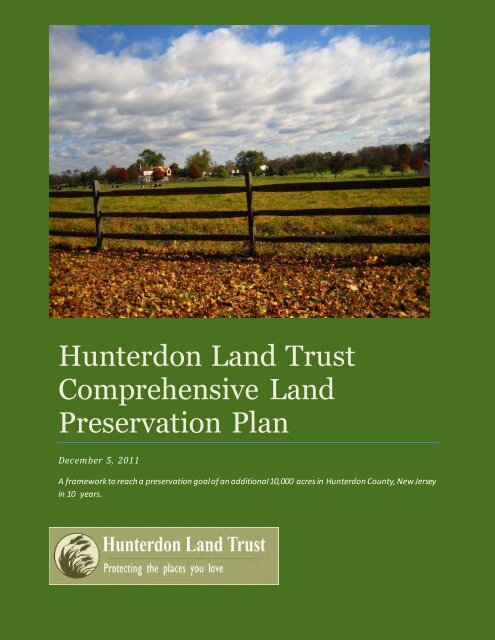
<strong>Hunterdon</strong> <strong>Land</strong> <strong>Trust</strong>Comprehensive <strong>Land</strong>Preservation <strong>Plan</strong>December 5, 2011A framework to reach a preservation goal of an additional 10,000 acres in <strong>Hunterdon</strong> County, New Jerseyin 10 years.
ContentsIntroduction/Background ....................................................................................................................3Methodology – Creating a Comprehensive <strong>Land</strong> Preservation <strong>Plan</strong> ........................................................6Existing Open Space <strong>Plan</strong>ning Efforts and Data .................................................................................6<strong>Plan</strong>ning Workshop .........................................................................................................................7Refining the <strong>Plan</strong>: After the Workshop ............................................................................................7<strong>Hunterdon</strong> <strong>Land</strong> <strong>Trust</strong>’s Comprehensive <strong>Land</strong> Preservation <strong>Plan</strong> ...........................................................9Project Region: Delaware River Scenic Corridor ........................................................................... 12Riegelsville to Milford Target Area .......................................................................................... 15Milford to Frenchtown Target Area......................................................................................... 16Frenchtown to Stockton Target Area ...................................................................................... 17Project Region: Delaware River Tributaries ................................................................................. 18Hakihokake Creek Target Area................................................................................................ 21Nishisakawick Creek Target Area ............................................................................................ 22Frenchtown Greenbelt Target Area (including Little Nishisakawick Creek and Copper Creek) ..... 23Lockatong Creek Target Area.................................................................................................. 24Wickecheoke Creek Headwaters Target Area .......................................................................... 25Rosemont Scenic Corridor Target Area.................................................................................... 26Alexauken Creek & Moore Creek Target Area .......................................................................... 27Project Region: South Branch – Raritan River .............................................................................. 28Califon Greenbelt Target Area ................................................................................................ 30Round Valley Greenbelt Target Area ....................................................................................... 31Grandin and Capoolong Target Area ....................................................................................... 32Flemington Raritan Greenbelt Target Area .............................................................................. 33Three Bridges Greenbelt Target Area ...................................................................................... 34Amwell Grasslands North and South Target Area..................................................................... 35Neshanic River Headwaters Target Area.................................................................................. 36Project Region: Sourland Mountain ............................................................................................ 37Project Region: North Branch – Raritan River ............................................................................. 38Page 1
Lamington River Target Area .................................................................................................. 39Rockaway River Target Area ................................................................................................... 40Lebanon Forest & Farmland Target Area ................................................................................. 43Bethlehem Forest & Farmland Target Area.............................................................................. 44Holland Forest & Farmland Target Area .................................................................................. 45Conclusion and Recommendations .................................................................................................... 46New Criteria for <strong>Land</strong> Acquisition projects ...................................................................................... 46Appendices ...................................................................................................................................... 48Appendix 1, <strong>Land</strong> Preservation Protection Priorities ........................................................................ 49Appendix 2, Workshop Agenda ...................................................................................................... 51Appendix 3, Acreage of <strong>Land</strong> Targeted for Preservation Per Target Area .......................................... 53Page 2
Introduction/BackgroundThe <strong>Hunterdon</strong> <strong>Land</strong> <strong>Trust</strong> (HLT) was incorporated in 1996 as a non-profit organizationcommitted to the preservation and protection of the rural character of <strong>Hunterdon</strong> County, NewJersey. During the last 15 years, HLT has become an extremely effective regional land trust.Through its continuing efforts, over 5,000 acres of farmland and open space have beenpreserved, advancing the land trust’s goals to preserve ecologically and agriculturally significantland and to create a legacy for conservation and stewardship.In 2010, the land trust completed a strategic plan to provide clarity and focus for theorganization and to guide its land preservation efforts for the next ten years to maximizeresources and opportunities. In its 2010 strategic plan, the organization established anambitious goal to:preserve another 10,000 acres of land with ecological, agricultural, scenic, recreationaland community value to ensure meaningful land preservation throughout <strong>Hunterdon</strong>County.This Comprehensive <strong>Conservation</strong> <strong>Plan</strong> provides a framework for that preservation goal andincludes a geographic focus to direct preservation efforts and criteria to evaluate projects.<strong>Hunterdon</strong> County, New Jersey: Over the past several decades, New Jersey in general and<strong>Hunterdon</strong> County specifically have experienced increased suburban sprawl in response torising development pressures. As development rose, so did the public’s support for landpreservation. With passage of the Garden State Preservation Act in 1998 and subsequent grantincentives that are part of the state Green Acres and Farmland Preservation Programs, thecounty and most municipalities began to levy open space taxes that pay for land preservationincluding a recentlyapproved dedicated tax levyfor county land preservationefforts, passed by 75% voterapproval in 2008.Dr. Rick Lathrop from TheCenter for Remote Sensingand Spatial Analysis atRutgers University and Dr.John Hasse from theGeospatial Research Lab atRowan University havepublished a series of studiesFigure 1 <strong>Land</strong> use in <strong>Hunterdon</strong> County 2007, NJDEP LULC 2007, CRIPage 3
that document the rapid rate of land-use change in New Jersey, particularly conversion ofproductive farmland and forests to development 1 . In July 2010, they analyzed a statewidedataset of aerial photographs from 1986 and 2007 and found that, compared to past studies,“what the data show is that urban development in the nation’s most densely populatedstate has continued unabated and in fact gained momentum up through 2007.”They go on to note that since 2007, NJ experienced over 16,000 acres of development a year.Since 1986, an area of 507 square miles was developed statewide. This is an area larger than thesize of <strong>Hunterdon</strong> County (438 square miles). Although this rate has certainly slowed due to therecent financial crisis and collapse of the real estate market, the result of this pace ofdevelopment is certainly apparent to anyone who lives in <strong>Hunterdon</strong> County.The total area of <strong>Hunterdon</strong> County is approximately 438 square miles or 280,121 acres. Ofthis, approximately 132,715 acres are either developed or permanently preserved as farmland oropen space while approximately 147,405 acres remains undeveloped and potentially vulnerableto development. If the land use patterns of the past are any indication of the future, the nextseveral decades will decide the fate of the remaining land of <strong>Hunterdon</strong> County. 2However, given the recent fiscal crises that the state and many municipalities are facing, as wellas the general impression that a lot of open space and farmland has already been preserved,public support for land preservation is beginning to erode and public funding is dwindling.Going forward, conservation efforts will need to be prudent and widely supported.The County of <strong>Hunterdon</strong> has developed a Comprehensive Farmland Preservation <strong>Plan</strong> whichwas adopted by the Freeholders on December 4, 2008, and a draft open space plan. However,the open space plan has not been officially adopted. The <strong>Hunterdon</strong> County Board of ChosenFreeholders adopted the Open Space, Farmland Preservation and Historic Preservation Policy#:2008-02, on October 7, 2008, revised October 5, 2010. This Policy (“Policy #:2008-02”) isintended to generally outline the Practices and Procedures of the Board of Chosen Freeholderswhen selecting, evaluating and acquiring interests in real property for Open Space, FarmlandPreservation and Historic Preservation Purposes by the County of <strong>Hunterdon</strong>. At the same time,the State, other non-profit land trusts, and individual municipalities each have theirpreservation targets, but these disparate plans do not provide a comprehensive forward-lookingvision to preserve open space and farmland county-wide. Even if these plans were quiltedtogether, they would not identify some important undeveloped areas in the county that warrantpreservation.Because of this lack of overall coordination of strategic open space planning, HLT realized thatan inclusive planning process and analysis was necessary. In order to continue preserving openspace and farmland and realize its mission, and maximize resources and opportunities, HLT felt1 Hasse, J., R.G. Lathrop, and John Reiser, Urban Growth and Open Space Loss in NJ 1986 through 2007.http://gis.rowan.edu/projects/luc/2 Analysis conducted by <strong>Conservation</strong> Resources using NJDEP <strong>Land</strong> Use <strong>Land</strong> Cover Data 2007, ESRI GIS ArcDesktop .Page 4
it had to develop a more comprehensive vision for preservation throughout <strong>Hunterdon</strong> County.In addition, they wanted to continue their strong tradition of working and coordinating withpublic and private preservation partners and willing landowners. HLT felt it was important tomake a compelling case to the public that the next several decades will decide the fate of whatthe county will look like and whether or not it retains its current rural charm and character, itsproductive farms, contiguous forests, diverse wildlife and high quality water resources.In order to do this, HLT compiled and synthesized the county’s extensive open space andfarmland preservation work along with the dozens of other sources of information related tonatural and cultural resources that would be helpful in creating a conservation vision.The Victoria Foundation and the <strong>Land</strong> <strong>Trust</strong> Alliance (LTA), a national land trust advocacy andsupport organization, provided funding to engage <strong>Conservation</strong> Resources (CRI) to assist HLTin preparing this conservation plan and to adopt the methodology, criteria and strategiesnecessary to guide its future land acquisition efforts. This process and the resulting plan will alsosatisfy one of the critical elements needed for land trust accreditation through LTA. HLT hasembarked on the accreditation process in 2011 and the development of a focused land plan is anessential element for accreditation.This plan also presents a conservation vision that can be used in the <strong>Hunterdon</strong> <strong>Land</strong> <strong>Trust</strong>’smarketing and outreach activities to better engage the public in land preservation activities. Itprioritizes project areas based on funding, local political support, and other opportunities. Atthe same time, the conservation plan is spatially explicit and can be used as a planning andproject management tool to target specific parcels for open space and farmland preservation.The plan identifies six Project Regions, with 22 Target Areas within these regions.This plan establishes a long term vision. The land trust recognizes that its success in any givenProject Region or Target Area is dependent upon willing landowners, conservation financing,and supportive partnerships. Further, the community’s input and participation in this landpreservation plan are essential to its realization. The land trust board and staff will review thisplan every two years to ensure that it continues to represent preservation goals and objectives,and will update the plan accordingly.Page 5
Methodology – Creating a Comprehensive <strong>Land</strong> Preservation <strong>Plan</strong>Existing Open Space <strong>Plan</strong>ning Efforts and DataOpen space and farmland preservation initiatives throughout New Jersey have been guided bynumerous conservation plans as well as other data that can be used in strategic conservationplanning. At virtually every level there are plans and accompanying maps ranging from localmunicipalities’ open space plans to important natural and agricultural resource areas identifiedby state agencies and non-profit organizations. In order to effectively and efficiently develop acomprehensive land preservation plan for the <strong>Hunterdon</strong> <strong>Land</strong> <strong>Trust</strong>, CRI collected andevaluated the most pertinent GIS data, both internally from HLT and externally from the Countyand State agencies.In 2005, HLT developed general land preservation project criteria that guided their landpreservation activities (Appendix 1). From a geographic standpoint, the criteria identified fivebroad regions; the Highlands, the Delaware River Corridor, the Musconetcong River corridor,the Lockatong Creek Corridor, and the Alexauken Creek Corridor. HLT targeted lands withimportant environmental, recreational, scenic, historic, and/or agricultural values. The 2005criteria place a priority on lands adjacent to already preserved lands, properties that arereasonably priced with willing sellers, and/or properties threatened with development.Although the land trust’s 2005 land preservation criteria provided a framework for identifyingand targeting specific preservation parcels, they were not spatially explicit, meaning the 2005project areas were simply large geographic areas of the county, like the Highlands, but lackedany target areas or criteria to help prioritize projects within those regions.Since these original land preservation criteria were developed, the land trust has experiencedsignificant organizational growth and preservation accomplishments, including the creation ofdedicated preservation staff positions and increased capacity to leverage more grant dollars forpreservation transactions. HLT is able to complete more transactions and has expanded itswork throughout the county. Given these factors, the land trust recognizes that these 2005criteria and project areas are too broad and lack the focus needed to direct its preservationefforts and provide an adequate filter to gauge potential projects.In addition to the land trust’s own preservation goals, <strong>Hunterdon</strong> County’s agriculturalpreservation plan and draft open space plan were both reviewed and included in this planningprocess. Both of these plans had parcel-specific mapping completed, which made display andsubsequent analysis easier.HLT views the county’s own vision for land preservation as integral to long term preservationsuccess. By complementing and supporting the county’s vision, the land trust can bring moreout-of-county conservation dollars to the table, maximize grant leveraging, and ensure thatPage 6
mutual preservation goals are met. Finally, a number of natural resource GIS data sets wereused, including critical area mapping from the New Jersey Water Supply Authority, New JerseyDepartment of Environmental Protection’s (NJDEP) Endangered and Threatened SpeciesProgram <strong>Land</strong>scape Project (both the highlands specific data and the statewide data), NaturalHeritage Priority Sites, conservation and agricultural preservation priorities from the NJHighland Council, and Garden State Greenways. Tax parcel data was available for the entireCounty, which allowed the identification of specific properties.<strong>Plan</strong>ning WorkshopCRI facilitated an interactive workshop with the Board of <strong>Trust</strong>ees and staff of the <strong>Hunterdon</strong><strong>Land</strong> <strong>Trust</strong> on June 4, 2011. The purpose of the workshop was to help HLT staff and trusteesdevelop preservation criteria and select and map the priority lands which HLT will seek toprotect in the next 5-10 years to achieve the goal to “Preserve 10,000 acres of land withEcological, Agricultural, Scenic, Recreational and Community value to ensure meaningfulland preservation throughout <strong>Hunterdon</strong> County.”The Workshop consisted of an introductory briefing and two interactive exercises (see Appendix2 for a detailed agenda of the workshop). The first exercise focused on identifying the potentialplaces to be protected, or Project Regions. The participants used large GIS maps that consistedof 2007 color aerial photographs, existing protected open space and preserved farmland, theCounty Farmland Preservation <strong>Plan</strong>, the draft County Open Space <strong>Plan</strong>, and parcels greater than40 acres in size. Using permanent markers, the board and staff outlined areas on the map thatincluded parcels with high resource value (good soils, wildlife habitat), adjacent to alreadypreserved properties, and targeted in other conservation plans.In the second exercise, the HLT Board and staff prioritized Target Areas within larger ProjectRegions. These Target Areas are smaller areas within the Project Regions where HLT wouldfocus its efforts in the short term and pursue preservation opportunities. During this session,HLT identified existing and potential funding partners within each of these Target Areas,explored whether or not there were known landowners willing to preserve their properties, andcategorized the local political will and resources for preservation.The board then prioritized two kinds of Target Areas—those where HLT would take the lead,and those where HLT would play a secondary role and support a partner that had taken thelead—to focus its proactive preservation efforts in the next 5-10 years to meet the strategic plangoal of 10,000 more acres preserved in <strong>Hunterdon</strong> County.Refining the <strong>Plan</strong>: After the WorkshopThe workshop results were digitized and compared to the natural resource data and other planspreviously identified to create a draft land-parcel specific plan. At the workshop, the board andstaff identified 13 Project Regions. After the workshop, HLT staff and board members furtherrefined the maps, consolidating the Project Regions into a total of 6, each with their own TargetPage 7
Areas of focus. Additionally, some Target Area boundaries were broadened to capture parcelswith high resource value.The conservation plan contains six Project Regions: Delaware River Tributaries, Delaware RiverScenic Corridor, Musconetcong Highlands, Raritan River – North Branch, Raritan River –South Branch, and Sourland Mountain. These six project areas include 22 Target Areas.In developing the GIS maps, tax parcel-based data was used to identify specific targetproperties. This underlying data is linked to public ownership records and will be used as a toolby HLT to proactively approach and educate landowners about the benefits of preserving theirland. Parcels 40 acres or greater were identified because it was the minimum acreage size to beincluded in the County’s Farmland Preservation <strong>Plan</strong>. This minimum acreage size will alsoallow additional focused targeting of lands and prioritization for the land trust.A general law of land conservation is the bigger the parcel size and the larger the area ofpreserved open space and/or preserved farmland, the better. From a Farmland Preservationperspective, having a critical mass of farms is important so that they can adequately supportneeded associated industries such as seed and fertilizer stores and farming equipment sales andrepairs. Having core areas of agriculture also ensures that farmland remains part of the localculture. For Open Space, many of the natural resource attributes are only found on largerparcels. Most if not all threatened and endangered species in New Jersey need large areas ofhabitat that only large protected areas provide. Water quality and quantity is better protectedwith large tracts. Finally, from an organizational operational perspective, preserving a smallproperty takes just as much time and energy as protecting large properties. The 40-acrethreshold strikes this balance. This does not mean that parcels smaller than 40 acres should notbe preserved. Valuable small parcels will be found in more developed areas of the county, insituations involving greenway connector parcels, or when adding onto already preserved openspaces. Some of these important parcels that are less than 40 acres were also identified in thisplan.Page 8
<strong>Hunterdon</strong> <strong>Land</strong> <strong>Trust</strong>’s Comprehensive <strong>Land</strong> Preservation <strong>Plan</strong>Project Regions and Target AreasPage 9
<strong>Hunterdon</strong> <strong>Land</strong> <strong>Trust</strong> has identified six Project Regions. Within these six Regions there are 22Target Areas.Project Region: Delaware River Scenic CorridorTarget Areas:o Riegelsville to Milfordo Milford to Frenchtowno Frenchtown to StocktonProject Region: Delaware River TributariesTarget Areas:o Nishisakawick Creeko Lockatong Creeko Rosemont Scenic Corridoro Frenchtown Greenbelt; Little Nishisakawick Creek, Copper Creeko Hakihokake Creeko Wickecheoke Creek Headwaterso Alexauken Creek & Moore CreekProject Region: Musconetcong HighlandsTarget Areas:o Lebanon Forests & Farmlando Bethlehem Forest & Farmlando Holland Forest & FarmlandProject Region: Raritan River North BranchTarget Areas:o Lamington Greenbelto Rockaway Creek HeadwatersProject Region: Raritan River South BranchTarget Areas:o Califon Greenbelt (portions in South Branch Project Area)o Amwell Grasslands North and Southo Three Bridges Greenbelto Round Valley Greenbelto Flemington Raritan Greenbelto Capoolong and Grandino Neshanic River HeadwatersProject Region: Sourland Mountain Project AreaThe ability to work in all Target Areas at any time is determined by organizational capacity,funding partners, willing landowners and public support. Therefore, the land trust willprioritize Target Areas based on capacity and opportunity and will review those prioritiesannually and adjust as needed.Each Project Region and Target Area encompasses unique natural, agricultural, and culturallandscapes which, in turn, impart unique challenges and opportunities for land preservation.Page 10
The following is a summary of each Region that makes up HLT’s strategic vision forpreservation. Included are some of HLT’s accomplishments in each Region and some of thepartners with whom HLT works to achieve preservation goals. Also included is a briefdescription of the Target Areas within the Regions.Page 11
Project Region: Delaware River Scenic CorridorStretching roughly between the Borough of Stockton to the town of Riegelsville, The DelawareRiver Corridor Project Region consists of land within two miles of the Delaware River.Spectacular natural vistas, forested ravines, historic villages, and critical trail connectors aresome of the natural and cultural resources in this area. Seven municipalities are included in thisProject Region: Holland Township,Milford Borough, AlexandriaTownship, Frenchtown Borough,Kingwood Township, StocktonBorough and Delaware Township.Perhaps the most well-known publicpark in the area is the Delaware andRaritan Canal State Park, whichcontains the D&R Canal Tow Path, oneof the most popular multi-use trails inthe state. This region boastsspectacular views of the DelawareRiver Valley, across to Bucks County,Pennsylvania, and State Route 29 ,thefirst designated scenic byway in NewJersey and also a designated FederalScenic Byway. This stretch of theDelaware River has also receivedfederal Scenic & Recreational Riverdesignation, with the Lower DelawareWild and Scenic River ManagementCommittee and the National ParkService charged with implementationof a management plan for the corridorto protect scenic values and waterquality and expand and improve publicrecreational opportunities.Creating buffers of preserved land along the Delaware River will help maintain wildlife habitatcritical to both aquatic and terrestrial species. Many species of migratory fish such as Americanshad travel far up the Delaware River to breed. This culturally important species (the City ofLambertville Shad Fest is a popular annual event) needs clean water to breed. The stateendangered bald eagle is known to utilize the banks of the Delaware River as foraging habitat.Preservation of land and maintenance of adequate natural buffers along the river as well aspreventing additional development, thereby reducing runoff, will help to protect bald eagles,Page 12
shad and many other species. HLT will focus on protecting the small, steeply wooded tributariesof the Delaware River, preserving the scenic vistas from Route 29, and protecting the rollingfarmland above the river.Past efforts:This region has been a high priority for the <strong>Hunterdon</strong> <strong>Land</strong> <strong>Trust</strong> from the beginning of theorganization. Since 1996, the land trust has facilitated the permanent preservation of 1968 acresof land. Some of these projects are as follows:Frenchtown Preserve (150 acres): HLT assembled a number of partners for the preservationeffort to permanently protect 148-acres of critical watershed land in Frenchtown Borough, thelast, large undeveloped tract of land in the town. Participants included the state of New JerseyGreen Acres Program, <strong>Hunterdon</strong> County, and Frenchtown Borough. The property was zonedfor high density development and an assessment of the site determined that as many as 117residential units could have been built on the property.Horseshoe Bend Park (250 acres) and Copper Creek Preserve (76 acres): HLT recentlyparticipated in the preservation of the Horseshoe Bend Park and Copper Creek Preserve, 326contiguous acres of open space and farmland saved from development. This project took over10 years of land trust effort, multiple funding partners, creativity and persistence. In the lastdecade, the New Jersey <strong>Conservation</strong> Foundation and HLT attempted to preserve this acreage,extending an offer to the landowner and beginning to secure funds. After that effort failed, NJCFand HLT remained persistent and hopeful, despite a Pennsylvania developer purchasing theproperty and securing development approvals for 58 houses, called “equestrian estates”. By thistime, early 2007, the state, HLT, and NJCF had secured adjoining properties. The state of NJtook the funding lead and acquired these sites for the state park system (Flagg and Kirkland).HLT and NJCF negotiated the purchase of this property, achieving success in 2011, despiteroadblocks and funding disappointments along the way. Kingwood Township and the state ofNew Jersey joined the land trusts in preserving this property as farmland and parkland, to bemanaged with adjoining lands for passive recreation and nature enjoyment by the public.Mergott in Kingwood Township (220 acres): In November 2001 HLT announced thepreservation of the Kugler Woods. This 220-acre property is almost entirely wooded withmature specimen hardwoods. It is a well-managed forest that has colonial history going back topre-revolutionary times. Named after its 18 th century owner, the Kugler Woods provided timberfor the famous Rodham Boat Works at the edge of the property. Here the Durham boats werebuilt to haul lime from Easton, upriver. The lime was used for agriculture and the buildingtrades, but the boats were also used by General George Washington for the surprise Christmascrossing downstream in Trenton. These wooded hills have many magnificent sugar maples andthe present owner has run a successful gravity-assisted maple syrup operation, believed to be<strong>Hunterdon</strong>’s only one. This was HLT’s first preservation in its Delaware Bluffs project area andit is a property that shows off the best of <strong>Hunterdon</strong>.Page 13
Preservation Partners:The State Green Acres Program is the most active partner in the region, and municipal supportfor open space and farmland preservation varies; Delaware Township and Kingwood Townshiphave been strong municipal partners in this region. New Jersey <strong>Conservation</strong> Foundation is anactive and supportive nonprofit partner. <strong>Hunterdon</strong> County has not had a strong showing as alead player in this region in recent years, despite it being identified as a priority area in thecounty’s draft preservation plan. However the County has provided nonprofit grants to HLT,Raritan Headwaters Association and D&R Greenway for projects in this area. The statefarmland preservation program is another funding partner and HLT has had luck in securingboth state and federal farmland preservation funds for projects in this region based on thequality of soils. The Department of Transportation has provided needed preservation fundingalong the Scenic Byway, which is Route 29 between Frenchtown and Stockton.Target Areas:The land trust has identified three Target Areas within The Delaware River Corridor ProjectRegion: Riegelsville to Milford, Milford to Frenchtown, and Frenchtown toStockton, the last one being a short-term, high priority for focused efforts with strongpartnerships. Descriptions of the Target Areas within the Delaware River Scenic CorridorProject Region follow.Page 14
Riegelsville to Milford Target AreaTotal Acreage Identified for Preservation - 438 acresTotal HLT Preserved Acreage – 476 acresThe Riegelsville to Milford Target Area consists of a narrow area of land along the DelawareRiver from Holland Township to Frenchtown Borough. It includes some industrial propertieslisted by the NJDEP as known contaminated sites including the Gilbert Generating Station andCorrugated Paper Group, Inc.This Area also includes the Milford Bluffs Natural Heritage Site, most of which has already beenprotected by the Natural <strong>Land</strong>s <strong>Trust</strong>. The Milford Bluffs Natural Heritage Site contains anatural red shale cliff community with rare and endangered plant species. The landscapeproject also identifies open fields in this area as important habitat for rare grassland bird speciesincluding Vesper sparrow.Page 15
Milford to Frenchtown Target AreaTotal Acreage Identified for Preservation - 531 acresTotal HLT Preserved Acreage – 422 acresThe Milford to Frenchtown Target Area falls within Holland and Alexandria Townships andFrenchtown Borough. The Delaware and Raritan Canal State Park forms a small protectedgreenway along the river. Like the Riegelsville to Milford Target Area, there are a few propertiesbordering the river that are on the DEP’s list of known contaminated sites, including CurtisPaper, Inc. in Milford. However, the majority of the land in this area consists of farmland andforest.The Hakihokake Creek is a small, wooded tributary to the Delaware that is currently largelyunprotected. Preservation efforts in this area should focus on expanding the D&R Canal StatePark and protecting the forest and farmland along the Hakihokake Creek. See more on theHakihokake in the Delaware River Tributaries Project Region below.Page 16
Frenchtown to Stockton Target AreaTotal Acreage Identified forPreservation – 2,271 acresTotal HLT Preserved Acreage – 477acresFrenchtown to Stockton Target Areais the largest Target Area within theDelaware River Scenic CorridorProject Area. Mostly located inKingwood Township, itencompasses some of the hilliestterrain along the Delaware in<strong>Hunterdon</strong> County and containsseveral iconic sites includingTreasure Island and Devil’s TeaTable. Like the rest of the DelawareRiver Corridor, this area is amixture of farms and forests.Three Natural Heritage Priority sitesare located here as well: Byram,Devil’s Tea Table, and TreasureIsland. Each of these sites provideshabitat for rare plants. In additionto several small, intermittenttributaries to the Delaware, thereare two larger tributaries within thisTarget Area, Copper Creek and Warford Creek.Page 17
Project Region: Delaware River TributariesThe Delaware River Tributaries ProjectRegion encompasses the watersheds ofthe streams of <strong>Hunterdon</strong> County thatfeed directly into the Delaware River.Many of the creek names are unique andare beloved by the locals. These includethe Hakihokake Creek, NishisakawickCreek, Lockatong Creek, AlexaukenCreek, and the Wickecheoke Creek. TheFrenchtown Greenbelt, Rosemont ScenicCorridor, and the Moore Creek are alsopart of the large Project Region.The Region includes portions of sixmunicipalities: Holland Township,Alexandria Township, Franklin Township,Kingwood Township, Delaware Township,and West Amwell Township. This isprimarily an agricultural landscape, andalthough there has been much farmlandpreservation activity, there still remainsmore to be accomplished. The streamcorridors and adjoining wetlands, vital tomaintain wildlife and water quality andquantity should also be preserved.Protection of drinking water supply is alsoa priority in this region considering thatthe D & R Canal is fed by the Delaware River, which serves millions of water users in centralNew Jersey; these tributaries are important to the overall water quality of the Canal.Building off of what the land trust has already accomplished in this region, particularly in theNishisakawick, Lockatong, and Alexauken Creek watersheds is a goal, focusing on parcels thatlink to already preserved lands, both farmland and open space, to provide for continuity forrecreation and protection of habitat, as well as water quality protection. Securing the last, largeremaining tracts of land in this region is also a goal.Page 18
Past efforts:In 2008, HLT preserved two family farms on Ridge Road in Kingwood and AlexandriaTownship, known as Middleton and Ramirez. HLT holds and monitors the farmland easementson these properties. In 2010, HLT preserved the Stamets farm in Holland Township, workingwith a conservation buyer who purchased the restricted farm.The <strong>Hunterdon</strong> <strong>Land</strong> <strong>Trust</strong> has focused efforts along the Lockatong Creek since itsincorporation and has preserved 767 acres in this Target Area.Lockatong Preserve: The land trust assembled its Lockatong Preserve through three separateland acquisition projects over three years (2003 – 2006)—the 34 acre Zega property, the 34 acreHenderson property, and the 103 acre Peters property. The first two transactions were lead bythe land trust, using Green Acres funding, county nonprofit funds, and municipal funds; thePeters transaction was a direct partnership between the county and the land trust and resultedwith both entities holding joint title to the property, with the county managing it under amanagement agreement. The Lockatong Preserve was the land trust’s first real success, showinghow years of diligent preservation work and assembling adjoining properties can result in thedevelopment of a community asset. The Lockatong Preserve remains one of the land trust’smost popular properties with many visits to the Mimi Upmeyer Trail, a hiking trail on the Zegaproperty that allows visitors to enjoy the beauty of the Lockatong Creek corridor.HLT has a history of working in this area with its Alexauken Creek Watershed Project. It hasalso worked in partnership with D&R Greenway <strong>Land</strong> <strong>Trust</strong> on the Moore's Creek Greenway(south of Lambertville). There are several areas of preserved open space including WashingtonCrossing State Park along the Delaware, United Water Company land in West Amwell, Donderoconservation easement in West Amwell, and the Howell Living History Farm, just over theborder in Mercer County.<strong>Hunterdon</strong> <strong>Land</strong> <strong>Trust</strong> has worked with partners to preserve several large properties in theRosemont Scenic Corridor Target area including the Thompson property and the Harmsproperty on Route 519.Preservation Partners:Delaware Township and Kingwood Township have been strong preservation partners—the willto preserve more exists; the limiting factor is the availability of funding. Leveraging funds fromother sources and not overwhelming municipal partners with limited resources are importantstrategies to long term success here. The NJ Water Supply Authority is a funding partner withinthe Lockatong Creek Target Area, provided individual parcels meet their natural resourcecriteria. The State of New Jersey Green Acres Program is a recent partner in this Project Region,provided land meets the criteria for management by the Division of Fish and Wildlife or theDivision of Parks and Forestry. West Amwell has funded projects in the Alexauken CreekTarget Area in the past, but future participation is not certain. Farmland preservation fundingis also a possibility. Holland Township and the County nonprofit grant program have beenfunding partners in the past. Alexandria Township has not partnered with the land trust on pastPage 19
projects and is unlikely to fund open space acquisitions, more likely to fund farmlandpreservation projects at this time.Potential partners in the Frenchtown Greenbelt Target Area include Frenchtown Borough, theGreen Acres State Direct program, SADC (grants and direct), the Federal farmland preservationprogram, and Kingwood Township. The <strong>Hunterdon</strong> County nonprofit grant program has beenutilized for past projects and projects will likely rank high for that program, given therecreational opportunities and natural resource value of this area.Similar to the Wickecheoke Creek Target Area, the partners for the Rosemont Scenic CorridorTarget Area include D&R Greenway <strong>Land</strong> <strong>Trust</strong> and New Jersey <strong>Conservation</strong> Foundation,Kingwood and Delaware Townships.Target Areas:<strong>Hunterdon</strong> <strong>Land</strong> <strong>Trust</strong> has identified six Target Areas within the Delaware River TributariesProject Region: Hakihokake Creek, Frenchtown Greenbelt, Lockatong Creek,Wickecheoke Creek Headwaters, Rosemont Scenic Corridor, and Alexauken Creek& Moore Creek. Descriptions of these Target Areas follow.Page 20
Hakihokake Creek Target AreaTotal Acreage Identified for Preservation – 2,455 acresHLT Preserved acreage - 211Located in Alexandria, Union andHolland Townships, theHakihokake Creek PreservationPriority is an area where<strong>Hunterdon</strong> County has preserveda lot of farmland. There are alsoseveral parks and open spaceparcels in the area including theCounty-owned Schick Reserve.The NJ Natural <strong>Land</strong>s <strong>Trust</strong> ownsand manages the Milford BluffsPreserve and Sweet HollowPreserve. Units of the ClintonWildlife Management Area fallwithin the area.Farmland preservation activity inthe region should continue inorder to develop an even moreconcentrated area of preservedfarmland. In addition, expansionof the Schick Reserve, ClintonWildlife Management Area, andthe Milford Bluffs Preserve wouldhelp to ensure preservation ofwater quality and quantity,wildlife habitat, and provide nature oriented public recreational opportunities.Page 21
Nishisakawick Creek Target AreaTotal Acreage Identified forPreservation – 2,882 acresTotal HLT preserved acreage-43 acresLocated in AlexandriaTownship, the NishisakawickCreek Priority Area consistsmostly of farmland. TheNJDEP <strong>Land</strong>scape Projectidentifies these farms asproviding habitat for raregrassland birds such asbobolink and well as the statethreatenedwood turtle. TheNishisackawick is a relativelynew Target Area for the landtrust.Page 22
Frenchtown Greenbelt Target Area (including Little Nishisakawick Creek and Copper Creek)Total Acreage Identified for Preservation – 1,922acresTotal HLT preserved acreage-639 acresThe area is primarily agricultural with significantfarmland preservation having happened on theperiphery. The steep, forested ravines of the LittleNishisakawick Creek and the Copper Creek formcorridors of important wildlife habitat and shouldalso be protected.Page 23
Lockatong Creek Target AreaTotal Acreage Identified forPreservation – 5,529 acres<strong>Hunterdon</strong> <strong>Land</strong> <strong>Trust</strong> Preservedacres: 767HLT has focused its efforts in theLockatong Creek watershed sinceits founding in 1996. Thiswatershed spans from FranklinTownship, through Delaware andKingwood. The Lockatong CreekPreservation Priority Area is one ofthe largest priority areas beingtargeted by <strong>Hunterdon</strong> <strong>Land</strong> <strong>Trust</strong>.This region contains forested andagricultural properties. HLT hasfocused on woodland preservationin this area up to now. HLT iscurrently working on farmlandpreservation funding programs inthis area. Funding depends uponsoil quality.<strong>Hunterdon</strong> <strong>Land</strong> <strong>Trust</strong> has beensuccessful at preserving open spacein this area with acquisitionsincluding the Lockatong Preserve and easements including Meadow Creek. HLT began itsefforts in this area in Delaware Township, with project activity increasing in Franklin Townshipand Kingwood in recent years. NJ Audubon has worked with HLT in this watershed because ofthe high value bird habitat that exists. State of New Jersey, Division of Fish and Wildlifemanages some properties in this watershed as wildlife management areas, after the State GreenAcres Program acquires those properties through the direct state acquisition program. The NewJersey Water Supply Authority has begun to evaluate the quality of this watershed and fundrestoration activities in an attempt to improve the quality of the stream for drinking waterpurposes. The Lockatong Creek feeds into the D & R Canal, which is managed by the Authorityas a drinking water supply for central New Jersey.Page 24
Wickecheoke Creek Headwaters Target AreaTotal Acreage Identified forPreservation – 1,942 acresLocated in Delaware Township,the Wickecheoke CreekHeadwaters Preservation TargetArea complements thetremendous efforts of the NewJersey <strong>Conservation</strong> Foundation.Recently, the D & R Greenway<strong>Land</strong> <strong>Trust</strong> has started to work inthe Plum Brook, a tributary of theWickechoeke.The landscape in this part of thecounty is a mixture of large foresttracts and productive farmland.The wetlands and streamcorridors in the southern portionof this project area providehabitat for the state threatenedwood turtle, while the large forestcomplex provides suitable habitatfor several additional threatenedspecies.Page 25
Rosemont Scenic Corridor Target AreaTotal Acreage Identified forPreservation - 894 acresTotal HLT preserved acreage-342acresRosemont is an area dotted withhistoric farm structures and rollinghills. HLT will work to preserve thislandscape through continuedFarmland and Open SpacePreservation. This priority area islocated in Kingwood and DelawareTownships and links the Lockatongwatershed with the Wickecheokewatershed.Page 26
Alexauken Creek & Moore Creek Target AreaTotal Acreage Identified for Preservation – 1,897 acresTotal HLT preserved acreage-644Preservation of the Alexauken Creek & Moore Creek Priority Area would help to preserve therural landscapes that surround the village of Ringoes and the City of Lambertville. Located inrural West Amwell Township, preservation of this area is important to people living in thesecommunities and this area of <strong>Hunterdon</strong> County. In addition to agricultural and forested areas,the Alexauken Creek and Moore Creek Project Area contains the Goat Hill Natural HeritagePriority Site, described by the Natural Heritage Program as a wooded, diabase hillside withendangered plants. Much of the farmland within this area is identified in the <strong>Hunterdon</strong>County Agriculture Development Board plan.Page 27
Project Region: South Branch – Raritan RiverThe South Branch Raritan RiverProject Area covers portions ofthe Highlands near Califon southto the agricultural grassland ofthe Amwell Valley. Preservationof land within this project area isextremely important for waterquality and quantity. The SouthBranch and its associatedreservoirs – Round Valley andSpruce Run – provide highquality drinking water for overone million NJ residents.Portions of this project area alsosurround Flemington, thedeveloped portions of RaritanTownship, and the Village ofRingoes.HLT goals for this Region includefocused efforts on importantwatershed properties, buildingconnectivity of preserved land;protecting the communitycharacter; providing recreationalopportunities for the small townsin the Region (Flemington,Califon, Three Bridges); andprotecting important wildlife habitat, including grasslands in theAmwells.Past Efforts:HLT began to focus on the South Branch Region in the early 2000s,with projects completed in most of the municipalities and with amultitude of partners.HLT’s Quakertown Preserve in Franklin Township is thecombination of two projects with two landowners, Pfaltz and Bodine.The Bodine Woods were preserved in 1999 by landowner MaryPage 28
Bodine and <strong>Hunterdon</strong> <strong>Land</strong> <strong>Trust</strong>. This 28-acre tract of woods, with a tributary of theCapoolong Creek, had frontage on Quakertown Road but no accessible parking area to accessthe trails. The benefit of the Pfaltz acquisition included the preservation of another building lotin Quakertown, and the creation of a safer, easier access for the public to access the BodineWoods Property for passive recreational pursuits.(Flemington Raritan Greenbelt Target Area) Case-Dvoor Farm in Raritan Township,Flemington, New Jersey, is the headquarters of <strong>Hunterdon</strong> <strong>Land</strong> <strong>Trust</strong> located in the historichouse on the property. There are also several historic agricultural structures, and 42 acres ofland. The land consists of agricultural fields, woods, wetlands, and waterways, including astretch of the Mine Brook, a tributary of the South Branch of the Raritan River. These physicalelements and how they have changed through the years tell the story of the farm and its role inthe larger community. The farm has been very important to the community in the past and isregarded as a county landmark today. The historic character and resources of the farm will bemaintained. This property was acquired by the South Branch Watershed Association andconveyed to HLT in 1999.(Amwell Grasslands Target Area) Two privately owned farms in East Amwell were preserved in2011 through the Township farmland preservation program, with a contribution to HLT from<strong>Conservation</strong> Resources’ Raritan Piedmont Wildlife Habitat Grant Program, which supports thepreservation of grassland bird habitat. One family has lived in this area for generations and waspleased to add their farm to several adjoining preserved farms in East Amwell, maintainingspecific wildlife habitat and preserving the rural farming character of the township.(Round Valley Greenbelt Target Area) In 2010, HLT accepted a conservation easement on CampWinnewald, a property which has a portion of the Prescott Brook and some forested areas,adjacent to the Round Valley Reservoir.Preservation Partners:The New Jersey Water Supply Authority and State Green Acres Program are strong partners inthis region with the Authority being proactive in identifying priority watershed properties forprotection. The municipalities are engaged, have plans and dedicated revenues, but are beingconservative given the economic realities and limitations they face. Leverage is the key in thisregion and more outside sources of funding, such as state and federal funds, are necessary tocontinue the pace of preservation. A large amount of farmland preservation has alreadyoccurred in the Amwell Grasslands Target Area. Partners in the area include New Jersey<strong>Conservation</strong> Foundation, who preserved the Barron Farm in East Amwell, and the Townshipsof East Amwell and Raritan who are both active in farmland preservation and D&R Greenway<strong>Land</strong> <strong>Trust</strong> which recently preserved Cider Mill Farm.Target Areas:The <strong>Land</strong> <strong>Trust</strong> has identified seven Target Areas in the South Branch-Raritan River ProjectArea: Califon Greenbelt, Round Valley Greenbelt, Grandin and Capoolong,Flemington-Raritan Greenbelt, Three Bridges Greenbelt, Amwell Grasslands Northand South, Neshanic River Headwaters. Descriptions of these Target Areas follow.Page 29
Califon Greenbelt Target AreaTotal Acreage Identified for Preservation – 1,764 acresThe Califon Greenbelt Target Area is located in Lebanon and Tewksbury Townships andsurrounds the historic village of Califon. This Target Area includes the Columbia Trail, whichspans dozens of miles in <strong>Hunterdon</strong> and Morris Counties and provides wonderful hiking andbiking opportunities. Ken Lockwood Gorge Wildlife Management Area is a popular fishing andhiking destination.Like most Target Areas in the Highlands of <strong>Hunterdon</strong> County, the Califon Greenbelt consists ofa mixture of forests and farmland. The forest provides habitat to the state endangered bobcat.While the farmland areas are important for many grassland bird species, they are not asextensive as the grassland areas in other parts of the county which are more likely to providehabitat for endangered and threatened bird species.Page 30
Round Valley Greenbelt Target AreaTotal Acreage Identified forPreservation – 3,419 acresTotal HLT preserved acreage-411 acresAs its name implies, theRound Valley GreenbeltPreservation Target Areaencircles Round Valley StatePark. Permanent protectionof this area would also help topreserve the easternboundary of the historicTown of Clinton.Round Valley State Park is apopular state recreation areaand supplies drinking waterfor millions in New Jersey. Inpartnership with ClintonTownship, and with theassistance of <strong>Conservation</strong>Resources, HLT recentlyfacilitated the preservation ofthe Windy Acres property,located in close proximity toRound Valley.In addition to the large state and municipal open space holdings in the area, there are severalpreserved farms. Round Valley reservoir provides habitat for bald eagles. In addition theforested areas north of route 78/22 provide habitat for the State Endangered bobcat. Theagricultural areas to the south of Round Valley Reservoir provide habitat to the StateThreatened Coopers Hawk.Page 31
Grandin and Capoolong Target AreaTotal Acreage Identified for Preservation – 1,333 acresTotal HLT preserved acreage-120 acresThe Grandin and Capoolong Target Area is located in Union and Franklin Townships. This areaincludes a number of historically significant farms, and is part of the Clinton Farms HistoricDistrict. Hoffman Park is a large County-owned park located in this priority area. There arealso several preserved open space parcels owned by Union Township and a few parcels ofpreserved farmland.In addition to the State Endangered bobcat, the larger farmland properties provide habitat tothe State Threatened Vesper sparrow. Preservation in this area should focus on expanding thepreserved farmland area within the Clinton Farms Historic District and expanding HoffmanPark.Page 32
Flemington Raritan Greenbelt Target AreaTotal Acreage Identified for Preservation - 945 acresTotal HLT preserved acreage-46acresThe Flemington RaritanGreenbelt Target Area is locatedaround <strong>Hunterdon</strong> <strong>Land</strong> <strong>Trust</strong>’sDvoor Farm and consists ofseveral large parcels locatednear Flemington. Preservationof this area would help to ensurethat the remaining rurallandscape surroundingFlemington is preserved,including land around the MineBrook and Walnut Creek.Page 33
Three Bridges Greenbelt Target AreaTotal Acreage Identified for Preservation – 1,581 acresThe Three Bridges Greenbelt Target Area is located in Readington and Raritan Townships andseeks to protect land along the main stem of the South Branch and the remaining large parcelsalong Route 202. The farms along Route 202 impart a somewhat rural atmosphere to peopletraveling to Flemington from the east.There are several large parcels that have already been preserved along the main stem of theSouth Branch, including the State-owned South Branch Wildlife Mangament Area and the<strong>Hunterdon</strong> County-owned Deer Path Park and South Branch Reservation. New Jersey Audubonand Conserve Wildlife Foundation have been actively workingwith farmers on public and private land, managing the area for thebenefit of grassland birds as part of their participation in theRaritan-Piedmont Wildlife Habitat Partnership.Page 34
Amwell Grasslands North and South Target AreaTotal Acreage Identified forPreservation – 1,966 acresTotal HLT preserved acreage-179acresThe agricultural landscape of theAmwell Grasslands Target Area iswidely recognized as one of themost important areas forthreatened and endangeredgrassland-dependent birds.Located in Raritan and EastAmwell Township, virtually thisentire area is a Natural HeritagePriority Site, is highlighted in The<strong>Land</strong>scape Project, and is a focalarea of the Raritan PiedmontWildlife Habitat Partnership.Page 35
Neshanic River Headwaters Target AreaTotal Acreage Identified for Preservation – 2,266 acresThe Neshanic River Headwaters Target Area is located in Delaware and East Amwell Townships.As a major tributary to the South Branch of the Raritan, protection of the headwaters wouldhelp to ensure continued water quality within the Raritan basin. The landscape is made upprimarily of farms. Farmland preservation efforts in the region should continue. This is a newTarget Area for <strong>Hunterdon</strong> <strong>Land</strong> <strong>Trust</strong>.Page 36
Project Region: Sourland MountainTotal Acreage Identified forPreservation - 862 acresThe Sourland Mountain spansthree counties and fivemunicipalities and is thelargest, most intact forest inCentral New Jersey. As such, itis a vitally important area forstate threatened andendangered wildlife andmigrating birds.The <strong>Hunterdon</strong> County portionof the Sourlands is located inEast Amwell and West AmwellTownships.Past Efforts:<strong>Hunterdon</strong> County owns andmanages the SourlandMountain Nature Preserve,which links to the NJ Natural<strong>Land</strong>s <strong>Trust</strong>’s HighfieldsPreserve in HopewellTownship, Mercer County.This large preserve alsocomplements preservation efforts undertaken by Somerset County. This is a new Region for<strong>Hunterdon</strong> <strong>Land</strong> <strong>Trust</strong>.Preservation Partners:Given the regional significance of this area, there are numerous partners working to preserve theSourland Forest. These include the Sourland <strong>Plan</strong>ning Council, Stony Brook-MillstoneWatershed Association, NJ <strong>Conservation</strong> Foundation, D&R Greenway <strong>Land</strong> <strong>Trust</strong>, and theRaritan Piedmont Wildlife Partnership (RPWHP). RPWHP is made up of these and severalother non-profits and local governments.Target Areas: The Region and the Target Area are one and the same.Page 37
Project Region: North Branch – Raritan RiverAs the second main stem ofthe Raritan River, protectionof the headwaters of theNorth Branch of the RaritanRiver is important tomaintain water quality andquantity.This Project Region is locatedin Readington and TewksburyTownships with a very smallportion in Lebanon Township(which forms part of theCalifon Greenbelt TargetArea).Past Efforts:This is a new Project Regionof focus for <strong>Hunterdon</strong> <strong>Land</strong><strong>Trust</strong>. PreservationPartners:The major preservationpartners in Lamington are theTewksbury <strong>Land</strong> <strong>Trust</strong> andthe Lamington Conservancy,both volunteer-based landtrusts that work primarily inthe Lamington River area.Target Areas: The land trust has identified two Target Areas within the North Branch-RaritanRiver Project Region: Lamington River and RockawayRiver. Descriptions of these Target Areas follow.Page 38
Lamington River Target AreaTotal Acreage Identified forPreservation – 3,011 acresThis Target Area surrounds<strong>Hunterdon</strong> County’s Cold BrookReserve in Tewksbury Township.Preservation of the lands in thisarea would also create a greenbeltaround the historic village ofOldwick and help protect theLamington River, a tributary to theNorth Branch of the Raritan River.Page 39
Rockaway River Target AreaTotal Acreage Identified forPreservation - 524 acresJust to the south of theLamington River Target Area isthe Rockaway River Target Area.Located in Readington Township,preservation of these parcelswould help to protect animportant tributary to the NorthBranch.Page 40
Project Region: Musconetcong HighlandsThe steep forested slopes and small patches of agriculture of the Musconetcong HighlandsProject Area help to protect the Musconetcong River, a federally designated Wild and ScenicRiver. Located in Bethlehem, Holland and Lebanon Townships, preservation of this regionwould maintain its unique character and protect the Musconetcong River. The MusconetcongRiver drains a 157.6 square mile watershed area in northern New Jersey, and as a major tributaryto the Delaware River, is part of the 12,755 square mile Delaware River watershed. There are5,045 acres of parks in the watershed, with hundreds of acres of park land along theMusconetcong River itself. The river valley provides for views of mature forests, farmlands andhistoric villages.Regionally important populations of wildlife and critical habitat for state listed threatened,endangered or rare species are present within the river corridor. The Musconetcong Riverwatershed lies entirely within the New Jersey Highlands Region, a landscape of nationalimportance as determined by the U.S. Forest Service and within the Atlantic Flyway, one of fourmajor migratory bird routes in North America.Page 41
With many of its tributaries being trout production streams, the Musconetcong River is one ofthe finest trout fishing streams in New Jersey. At periods of higher flows, the river is also anexcellent paddling river. There are miles of hiking trails, particularly in the upper end of thecorridor at Allamuchy-Stevens and Point Mountain State Parks.Past Efforts:<strong>Hunterdon</strong> <strong>Land</strong> <strong>Trust</strong> helped to preserve the Crystal Springs Property, which is now part ofTeetertown Ravine Nature Preserve.In Bethlehem Township, open space properties include the Musconetcong Wildlife ManagementArea and the numerous areas that <strong>Hunterdon</strong> <strong>Land</strong> <strong>Trust</strong> has helped preserve including theJugtown Mountain Reserve, Tower Hill Reserve, Reilly and Ahlemeyer Preserves, Roerigproperty, Heilemann property, and Springhouse Associates property.The Roerig property directly adjoins two county parks: Jugtown and Tower Hill in BethlehemTownship. HLT partnered with NJWSA and the Township to preserve 40 acres, create a link onthe Highlands Trail and connect these two county parks and two other properties alreadypreserved by NJWSA with HLT help, the Reilly and Ahlemeyer properties. This propertyconsists of woodlands and some cleared forested areas now in succession after 20 years of nocutting. Mulhockaway Creek, part of the Upper Raritan Watershed, crosses the property andruns into the Spruce Run Reservoir area. The property has scenic vistas and several wetlandareas.Preservation Partners:The main funding and management partners in this area are <strong>Hunterdon</strong> County, the State ofNew Jersey Green Acres Program and the municipalities.Target Areas: The land trust identified three Target Areas within the Musconetcong HighlandsProject Region: Lebanon Forest & Farmland, Bethlehem Forest & Farmland, andHolland Forest & Farmland. Descriptions of these Target Areas follow.Page 42
Lebanon Forest & Farmland Target AreaTotal Acreage Identified for Preservation – 1,937 acresTotal HLT preserved acreage- 290 acresPoint Mountain, the Musconetcong River Reservation, and Teetertown Ravine Nature Preserveare extremely scenic and popular <strong>Hunterdon</strong> County Parks within this Target Area. TheMusconetcong River is one of the most popular places in New Jersey to fish for native trout.The banks of the Musconetcong provide Bald Eagle Foraging Habitat and the forests in thisregions are habitat for the state endangered bobcat.Page 43
Bethlehem Forest & Farmland Target AreaTotal Acreage Identified for Preservation – 2,455 acresTotal HLT preserved acreage-589 acresThe Bethlehem Forest & Farmland Target Area boasts large areas of fertile, preserved farmlandalong the Musconetcong River. In addition to farmland with statewide important soils, this areaprovides habitat to the federally listed bog turtle.Page 44
Holland Forest & Farmland Target AreaTotal Acreage Identified for Preservation – 871 acresTotal HLT preserved acreage-809 acresSpanning the lower portion of the Musconetcong River to its confluence with the DelawareRiver, the Holland Forest & Farmland Target Area is a place HLT has been working in for thelast several years. <strong>Hunterdon</strong> County’s Musconetcong Reserve and the State’s MusconetcongRiver Wildlife Management Area provide public access to the river. They also form animportant part of the string of preserved land along the entire length of the MusconetcongRiver.Page 45
Conclusion and RecommendationsThis <strong>Land</strong> Preservation <strong>Plan</strong> provides a bold vision for the future of <strong>Hunterdon</strong> County and the<strong>Hunterdon</strong> <strong>Land</strong> <strong>Trust</strong>. The preservation of the land identified in this report is highly desirableand would ensure high quality drinking water, a productive farming community, adequatewildlife habitat and a high quality of life for <strong>Hunterdon</strong> County residents. However,preservation on this large scale cannot be accomplished all at once, or by any singleorganization. Obviously, a relatively small organization like <strong>Hunterdon</strong> <strong>Land</strong> <strong>Trust</strong> needs to bestrategic in its on-the-ground efforts to preserve land, and to prioritize its efforts.Within each of these target areas, unpreserved parcels over 40 acres represent a total of 47,827acres. Of the 22 Target Areas identified in the plan, the HLT board of trustees has decided toinitially focus on six areas:Flemington Raritan Greenbelt, Frenchtown to Stockton, Hakihokake Creek, Bethlehem Forest &Farmland, Round Valley Greenbelt, and Lockatong Creek. Further, the land trust has prioritizedtwo Target Areas, the Wickecheoke Creek Headwaters and Lamington Greenbelt, to supportother groups (e.g., New Jersey <strong>Conservation</strong> Foundation and Readington Township) who haveestablished themselves as leaders in these areas:<strong>Hunterdon</strong> <strong>Land</strong> <strong>Trust</strong>’s existing Criteria for <strong>Land</strong> Acquisition should be amended to includethese areas.New Criteria for <strong>Land</strong> Acquisition projectsThe following criteria shall be used by the <strong>Hunterdon</strong> <strong>Land</strong> <strong>Trust</strong> in determining whichproperties will be selected for preservation efforts:1. The <strong>Hunterdon</strong> <strong>Land</strong> <strong>Trust</strong> is presently working proactively within the following sixtarget areas as identified in the 2011 Comprehensive <strong>Land</strong> Preservation <strong>Plan</strong>:Flemington Raritan Greenbelt, Frenchtown to Stockton, Hakihokake Creek, BethlehemForest & Farmland, Round Valley Greenbelt, and Lockatong Creek. Properties in theseTarget Areas will be given consideration for preservation.2. Properties must display important environmental values, good recreational values, goodscenic value, important historic values, or important agricultural value.3. Properties that adjoin other preserved lands will be given preference over equivalentproperties that stand alone.4. Properties that are believed to be threatened with imminent development will be givenpriority over properties without development pressure.5. Properties that represent good value will be given high priority. Properties with ownerswilling to make donations or partial donations will be given priority over properties thatrequire full fair market value for preservation.6. Preference will be given to properties over 40 acres.HLT staff will expend effort to proactively contact landowners within these six target areas.They will work with other non-profits, and local and county governments to help preserve theselands. The total acreage of identified parcels over 40 acres within these six areas is 17,000 acres.Page 46
Even though HLT will focus on these areas, all 17,000 acres will not have willing landowners,funding partners, nor meet all of the criteria developed by the board. Although ambitious, thisprovides ample opportunity to develop projects within the region and attain the goal ofstrategically preserving 10,000 acres.At the same time, the remaining 16 target areas will not be ignored. Where HLT can rely onother non-profits or governments to take the lead in these areas, it will gladly do so. If projectsdevelop within the other 16 target areas, HLT <strong>Land</strong> Acquisition Committee and Board of<strong>Trust</strong>ees will evaluate whether or not the project could and should best be completed by anotherentity, or, if not, whether HLT could take the lead on the project.It is fully expected that the six target areas will change over time. The board will review theseareas every year and make revisions to the plan as appropriate. For example, HLT trustees mayrealize significant success in these six target areas and feel that they can start to work inadditional areas. Another reason to change target areas is the fact that the ability andwillingness of certain local governments to preserve land may change over time. In generalduring the last few years, wehave seen more reluctance bymany towns to preserve openspace. A lot of this reluctanceis due to the current fiscal crisisas was discussed earlier in thereport. If HLT were to findthat local funding and supportwas questionable or nonexistentin one of its targetareas, it might switch andrefocus its efforts in acommunity where there ismore substantial support.With land preservation at thecore of its mission, <strong>Hunterdon</strong><strong>Land</strong> <strong>Trust</strong> will continue towork on educating residents inthe other 16 target areas on theimportance for conservation inthese areas. The rationale thatwas used in the development ofthis plan will provide the basisfor communicating the urgencyfor protecting these areas.Page 47
AppendicesPage 48
Appendix 1, <strong>Land</strong> Preservation Protection Priorities<strong>Hunterdon</strong> <strong>Land</strong> <strong>Trust</strong> AllianceUpdated 10/22/05Approved by <strong>Land</strong> Acquisition Committee: 9/05Approved by full board: 9/05<strong>Land</strong> protection project policies and selection processes:The <strong>Hunterdon</strong> <strong>Land</strong> <strong>Trust</strong> Alliance is committed to fulfilling its mission of preserving and protecting therural character and natural resources of <strong>Hunterdon</strong> County, New Jersey. This is accomplished througheducation and outreach to landowners; acquisition of conservation easements or fee interest inproperties; and stewardship and management of preserved properties. The staff and board of the landtrust agree to the following process to facilitate land protection projects:1. Staff/board will fully investigate all potential projects through conversations with thelandowner; site visits to the properties; and scrutiny of the public conservation value, andagricultural and natural resource value of the property;2. Staff/board will evaluate each potential project using adopted <strong>Land</strong> Protection Project Criteriaand checklist3. Staff shall ensure that proper due diligence is conducted for each transaction to reduce risk tothe organization and meet obligations of the Green Acres program. This shall include acomplete environmental assessment, title search and insurance commitment, survey, legalreview and approval of all documents, and appraisals.4. In the event of a donation for which the donor seeks a charitable income tax deduction,staff/board shall inform the landowner of Internal Revenue Code §170(h) standards fordeductibility (see attached) and encourage landowners to seek professional counsel and advicewith regard to these requirements. This is not meant to construe that HLTA board/staff shallcertify to the value of the donation.5. The <strong>Land</strong> Acquisition and Stewardship Committee of the board shall review all proposedprojects and make recommendations to the full board of trustees to move forward with projectsand make expenditures related to due diligence activities;6. As per the by-laws adopted in 1996, the Board of <strong>Trust</strong>ees and the Executive Committee shallhave final approval authority for all land protection projects and budgets related toexpenditures to support land preservation activities;7. HLTA shall make all reasonable attempts to receive 100% compensation of technical expenses,including appraisal, survey, title, legal, and environmental assessments, for each project throughthe following sources: Green Acres funding, landowner contributions, municipal contributions,non-profit contributions, and any other possible source.8. HLTA shall make all reasonable efforts to secure contributions to our permanent stewardshipendowment fund for both conservation easement defense and monitoring and propertymanagement. When conservation easements and fee properties are purchased at full fairmarket value, the board recommends an endowment donation of $5,000 or 1% of the purchaseprice, whichever is higher. When conservation easements and fee properties are donated orPage 49
sold at a significant bargain, a cash endowment is required and will be negotiated based onfactors such as the size of the property, the restrictions of the easement, and the financialabilities of the donor. The board understands that individual circumstances may restrict the sizeof a donation and reserves the right to negotiate endowments based on this. Staff isresponsible for negotiating endowments subject to board approval.9. HLTA shall make all reasonable efforts to manage fee owned properties in accordance withmanagement plans that address natural resource protection and provide passive publicrecreational opportunities.10. HLTA shall not enter into contracts to purchase property or conservation easements fromcurrent <strong>Trust</strong>ees. Transactions involving current <strong>Trust</strong>ees shall be limited to donations ofproperty or conservation easements; all land acquisition criteria and procedures shall apply.Purchase acquisitions involving former trustees may not be negotiated until one year after theboard member has resigned or their board term has expired.Criteria for <strong>Land</strong> AcquisitionThe following criteria shall be used by the <strong>Hunterdon</strong> <strong>Land</strong> <strong>Trust</strong> Alliance in determining whichproperties will be selected for preservation efforts:*The <strong>Hunterdon</strong> <strong>Land</strong> <strong>Trust</strong> Alliance is presently working within the following four project areas: TheHighlands, The Delaware River corridor, the Lockatong Creek corridor and the Alexauken Creekcorridor. Properties in one of these project areas will be given consideration for preservation.*Properties must display important environmental values, good recreational values, good scenicvalue, important historic values, or important agricultural value.*Properties that adjoin other preserved lands will be given preference over equivalent propertiesthat stand alone.*Properties that are believed to be threatened with imminent development will be given priorityover properties without development pressure.*Properties that represent good value will be given high priority. Properties with owners willing tomake donations or partial donations will be given priority over properties that require full fairmarket value for preservation.*Properties that present opportunities for easy preservation will be given priority over highlycomplex and time-consuming projects.*Projects which can result in preservation of land that has met all or some of the above criteria andwill not require onerous management practices will be given priority.Page 50
Appendix 2, Workshop Agenda<strong>Hunterdon</strong> <strong>Land</strong> <strong>Trust</strong><strong>Conservation</strong> <strong>Plan</strong> Board WorkshopSaturday, June 4, 2011Purpose of Workshop:Help HLT staff and trustees develop criteria and select and map the priority lands which HLT will seek toprotect in the next 5 years to achieve the new HLT goal to “Preserve 10,000 acres of land withEcological, Agricultural, Scenic, Recreational and Community value to ensure meaningful landpreservation throughout <strong>Hunterdon</strong> County.” The Workshop will consist of an introductory briefing, andtwo interactive exercises. The first exercise will focus on identifying the potential places to be protected.The second exercise will assist in prioritizing project areas by focusing on information to identify thespecific project areas that can realistically be protected more easily.Introduction and Background (9:10 AM – 9:30 AM)Introduce participants and facilitatorReview agendaProvide background for discussions, including:HLT Strategic <strong>Plan</strong>Recent Organizational Assessment for LTA AccreditationReview existing date and priorities of other conservation organizationsProvide the group with information that exists about the four resources areasIdentify areas of protection and begin to build a framework for prioritizing these areas. Ecological - NJ ENSP <strong>Land</strong>scape <strong>Plan</strong>; RPWHP <strong>Plan</strong> and <strong>Hunterdon</strong> County OpenSpace <strong>Plan</strong> Agricultural – Areas identified in SADC County <strong>Plan</strong>; Primary soils Scenic – Historic sites, NJDOT scenic roads and <strong>Hunterdon</strong> Co. Open Space <strong>Plan</strong> –and Recreational value - Areas identified in <strong>Hunterdon</strong> County Open Space <strong>Plan</strong>Discussion of deliverables which will result from workshopFirst Exercise: (9:30 AM – 11:30 AM)Participants will discuss the areas which they think should be priorities for preservation, basedupon the briefing materials and their personal knowledge of the County, and why these areasshould be a priority. We will spend 20 minutes, more or less, on each of the followingcategories: ecological; agricultural; scenic and recreational/community importance. At the end ofthis session, we will mark up a large map of <strong>Hunterdon</strong> County to show the rough boundaries ofpotential project areas. We will also spend some time as needed, to add some additional“programmatic” projects or projects areas, to the extent that these projects or project areas can bePage 51
identified, such as important tracts in urban areas, or priorities that may not otherwise be capturedby the other categories.(11:30AM – 12:15 PM) Lunch BreakSecond Exercise: (12:15 PM – 2:00 PM)Provide the group with information on what protecting 10,000 acres actually looks like, in thescale of the entire County, and help to develop a consensus on how to prioritize potential projectthe areas by taking into such things a s available partners, funding opportunities, and communityand political support for protecting land. (10 minutes)Discuss some potential criteria to be used to conduct a reality check of the potential project areasthat are likely to be easier and more difficult to protect. (20 minutes)For example:- Funding opportunities and challenges, e.g. where the SADC will fund; RPWHP areas; Countyopen space; Townships with open space funds that are interested in protecting land, areas wherepartners are active or not- <strong>Land</strong>owner willingness – identify areas where staff and trustees know willing landowners with aninterest in protecting their lands- Community and elected official support – those townships that have funds and are willing andable to contribute to open space or farmland acquisition- Size – identify the properties based on size and provide a tally of this breakdown:o over 500 acres;o 200-400 acreso 100-200 acreso 40-100 acresApply criteria to select 12-15 of the potential project areas where HLT should take the lead or bea willing partner to other organizations. (1 hour)Participants then are provided with two dots/votes to rank the priority of these 12-15 projectareas. (15 minutes – discussion and lobbying encouraged)Discussion of Outreach Efforts for the Draft <strong>Plan</strong>. (2:00 PM – 2:20 PM)o Publication of draft external map of project areaso Posting of draft map at Farmer’s Market for public markup and commentso Other forms of outreach to public and partnerso Preparation and publication of final planSummary and Wrap-Up, and Adjournment (2:20 PM – 2:30 PMPage 52
Appendix 3, Acreage of <strong>Land</strong> Targeted for Preservation Per Target AreaTarget AreaIdentified AcreageAlexauken Creek & Moore Creek 4,738Amwell Grasslands North 1,966Amwell Grasslands South 1,291Bethlehem Forest & Farmland 2,455Califon Greenbelt 1,764Grandin and Carpoolong 1,333Frenchtown Greenbelt 1,922Frenchtown to Stockton 2,271Hakihokake Creek 2,455Holland Forest & Farmland 871Lamington River 3,011Lebanon Forest & Farmland 1,937Lockatong Creek 5,529Milford to Frenchtown 531Neshanic River Headwaters 2,266Nishisakawick Creek 2,882Flemington Raritan Greenbelt 945Riegelsville to Milford 438Rockaway River Headwaters 524Rosemont Scenic Corridor 894Round Valley Greenbelt 3,419Sourland Mountain 862Three Bridges Greenbelt 1,581Wickecheoke Creek Headwaters 1,94247,827Page 53