bathing water profile - South West Water
bathing water profile - South West Water
bathing water profile - South West Water

You also want an ePaper? Increase the reach of your titles
YUMPU automatically turns print PDFs into web optimized ePapers that Google loves.
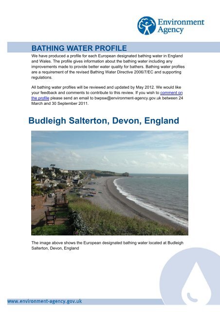
BATHING WATER PROFILEWe have produced a <strong>profile</strong> for each European designated <strong>bathing</strong> <strong>water</strong> in Englandand Wales. The <strong>profile</strong> gives information about the <strong>bathing</strong> <strong>water</strong> including anyimprovements made to provide better <strong>water</strong> quality for bathers. Bathing <strong>water</strong> <strong>profile</strong>sare a requirement of the revised Bathing <strong>Water</strong> Directive 2006/7/EC and supportingregulations.All <strong>bathing</strong> <strong>water</strong> <strong>profile</strong>s will be reviewed and updated by May 2012. We would likeyour feedback and comments to contribute to this review. If you wish to comment onthe <strong>profile</strong> please send an email to bwpsw@environment-agency.gov.uk between 24March and 30 September 2011.Budleigh Salterton, Devon, EnglandThe image above shows the European designated <strong>bathing</strong> <strong>water</strong> located at BudleighSalterton, Devon, England
Designation details under the current Bathing <strong>Water</strong> Directive (76/1160/EEC)Local Authority: East Devon District Council• Environment Agency Region: <strong>South</strong> <strong>West</strong>• Year designated: 1988The Environment Agency monitors and assesses <strong>bathing</strong> <strong>water</strong> quality at eachdesignated <strong>bathing</strong> <strong>water</strong> in England & Wales annually between May and September.The monitoring results and annual compliance are all published on the EnvironmentAgency website via our interactive map service.Bathing <strong>water</strong> map%, Surface <strong>water</strong> outfall!( River or streamEA <strong>bathing</strong> <strong>water</strong> sampling location#* Emergency or storm overflow") Treated sewage works outfall $+ Disused outfall#* Grey <strong>water</strong> outfall¯#*#*(!(!(!#*© Crown Copyright and database right 2011. All rights reserved. Ordnance Survey licence number 100026380.Bathing <strong>water</strong> descriptionBudleigh Salterton is at the mouth of the River Otter on the south coast of Devon. It is apebble beach resort, approximately one kilometre wide, backed by the promenade andcliffs.
Catchment mapCatchment descriptionThe catchment surrounding Budleigh Salterton is approximately 24,200 hectares. TheKnowle Stream is approximately five kilometres long and flows from LympstoneCommon through farmland and Budleigh Salterton to the sea at the beach. TheKersbrook is approximately six and a half kilometres long and flows from BictonCommon through farmland to East Budleigh. It continues south flowing parallel to theRiver Otter and enters the sea at Budleigh beach.The River Otter rises on the Blackdowns and flows southwest past Upottery, Monkton,Moniton, Ottery St Mary and Newton Poppleford until it reaches the sea near BudleighSalterton. It has a number of tributaries including the River Tale, River Love and RiverWolf. The steep catchment means rain runs off rapidly into the Otter. Land in thecatchment is mainly used for agriculture, with more than 50 farms.Pollution management<strong>Water</strong> quality at a <strong>bathing</strong> <strong>water</strong> is dependent upon the type and area of land (thecatchment) draining to the <strong>water</strong> and the activities undertaken in that catchment.It is the Environment Agency’s role to drive improvement of <strong>water</strong> quality at <strong>bathing</strong><strong>water</strong>s that are at risk of failing European standards. The following sections give anindication of potential sources of pollution, conditions under which they may arise andmeasures put in place to improve <strong>water</strong> quality.
Streams and riversStreams and rivers are typically affected by human sewage, animal slurry and runofffrom roads. There are two streams which flow across the beach to the east (Kersbrook)and to the west (Knowle Brook) of our monitoring point (marked by the green circles onthe <strong>bathing</strong> <strong>water</strong> map). The River Otter also enters the sea to the east of ourmonitoring point (marked by a green circle on the <strong>bathing</strong> <strong>water</strong> map). We havemonitored the River Otter since 1987 and found that <strong>bathing</strong> <strong>water</strong> quality is worseafter heavy rainfall.Our investigationsWe are using a DNA tracing technique to help us identify whether sources of faecalpollution are human or animal.Working with <strong>water</strong> companiesHistoryThe <strong>South</strong> <strong>West</strong> <strong>Water</strong> sewage treatment scheme for Budleigh Salterton wascompleted in 1997. Sewage from Budleigh Salterton is pumped to the Exmouthsewage treatment works (STW) for treatment. The scheme also included someresewerage work. The original outfall at Otterton Ledge (Lime Kiln) has been retainedas a CSO.Sewage treatment works outfallsDischarges from sewage treatment works have improved substantially in England andWales since the 1980s.Emergency/storm overflowsThe majority of sewers in England and Wales are “combined sewers” and carry bothsewage and surface <strong>water</strong> from roofs and drains. A storm overflow operates duringheavy rainfall when the sewerage system becomes overwhelmed by the amount ofsurface <strong>water</strong>. The overflow prevents sewage from backing up pipes and floodingproperties and gardens. An emergency overflow will only operate infrequently, forexample due to pump failure or blockage in the sewerage system.There is an emergency overflow from the Lime Kiln pumping station (marked by anorange triangle on the <strong>bathing</strong> <strong>water</strong> map), that discharges to the Kersbrook 400metres (m) from our monitoring poing. There is a storm overflow from the Lime Kilnpumping station (marked by an orange triangle on the <strong>bathing</strong> <strong>water</strong> map), thatdischarges to the sea at Ottern Ledge 1.3km to the east of our monitoring point.There is a storm overflow at Marine Parade at SY06648186 (marked by an orangetriangle on the <strong>bathing</strong> <strong>water</strong> map), that discharges to the Knowle Stream at the beach200m west of our monitoring point. These overflows prevent local homes from being
flooded with sewage after very heavy rainfall or emergency breakdown at the sewagepumping station. The operation of the overflows can lead to a drop in <strong>bathing</strong> <strong>water</strong>quality.Working with Local AuthoritiesHeavy rain falling on pavements and roads often flows into surface <strong>water</strong> drains orhighway drains, ending up in local rivers and, ultimately, the sea. The quality of <strong>bathing</strong><strong>water</strong> may be adversely affected as a result of such events.The urban area of Budleigh Salterton immediately behind the beach is served by acombined (surface and sewer) system. Surface <strong>water</strong> can flow into the River Otter,Kersbrook, and Knowle Stream from urban areas, outfall pipes and highway drains.This can affect <strong>bathing</strong> <strong>water</strong> quality, particularly after periods of rainfall. We haveregularly inspected and sampled surface <strong>water</strong> outfalls.MisconnectionsWrongly connected domestic waste <strong>water</strong> pipes can also affect the <strong>bathing</strong> <strong>water</strong>quality. We have checked the local sewerage system for misconnections. We areworking with East Devon District Council and <strong>South</strong> <strong>West</strong> <strong>Water</strong> to identify and rectifyany problems.Modern sewerage systems have two separate systems, one takes foul sewage tosewage treatment, the other takes rain<strong>water</strong> runoff through surface <strong>water</strong> drains torivers, lakes and the sea. Misconnections occur when waste <strong>water</strong> pipes are plumbedinto surface <strong>water</strong> drains instead of the foul <strong>water</strong> sewerage system. This can give riseto pollution when the waste <strong>water</strong> is discharged directly to the environment through thesurface <strong>water</strong> drain. For example, a washing machine or toilet may be incorrectlyplumbed so that it discharges to the surface drain rather than the foul sewage drain.Working with the farming communityThere are more than 50 farms in the catchment. During and after periods of heavyrainfall, runoff to the River Otter from agricultural land is greatly increased, and thequality of the <strong>bathing</strong> <strong>water</strong> can be reduced.We are working with Natural England and farmers on Catchment Sensitive Farmingprogrammes to encourage better farming practices and improve <strong>water</strong> quality in thesurrounding areas.Working with IndustryWe have worked with businesses on the small industrial estate at Heath Park inHoniton to ensure there is no affect on <strong>bathing</strong> <strong>water</strong> quality at Budleigh Salterton.
AlgaeSeaweed (macroalgae) and phytoplankton (microscopic algae) are a natural part of themarine and fresh<strong>water</strong> environment. Below we note whether these have been recordedin quantities sufficient to be a nuisance.Seaweed (macroalgae)This <strong>bathing</strong> <strong>water</strong> does not have a history of large amounts of seaweed (macroalgae).Phytoplankton(microscopic algae)Phytoplankton increase in number at certain times of the year and this process isknown as a phytoplankton bloom. These blooms can discolour the <strong>water</strong> or form as afoam on the <strong>water</strong>. Our research shows this <strong>bathing</strong> <strong>water</strong> has a history ofphytoplankton blooms.Further information<strong>Water</strong> Framework DirectiveThe <strong>Water</strong> Framework Directive (WFD) establishes a common approach to managing<strong>water</strong> within the European Community. The environmental objectives for the WFD willbe delivered through the actions described in the River Basin Management Plans(RBMPs). Actions identified in the RBMPs for other improvements, also contribute toimprovements in <strong>bathing</strong> <strong>water</strong> quality. The River Basin Management Plans arepublished on the Environment Agency websiteA glossary for this <strong>profile</strong> is available on the Environment Agency website.About this documentWritten: February 2011Next update: April 2012All <strong>bathing</strong> <strong>water</strong> <strong>profile</strong>s will be reviewed and updated by May 2012. We would likeyour feedback and comments to contribute to this review. If you wish to comment onthe <strong>profile</strong> please send us an email to bwpsw@environment-agency.gov.uk between24 March and 30 September 2011.