History of the Town of Huntersville
History of the Town of Huntersville
History of the Town of Huntersville

Create successful ePaper yourself
Turn your PDF publications into a flip-book with our unique Google optimized e-Paper software.
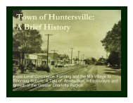
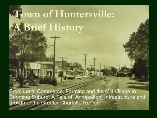
<strong>Town</strong> <strong>of</strong> <strong>Huntersville</strong>:A Brief <strong>History</strong>From Local Commerce, Farming and <strong>the</strong> Mill Village toBooming Suburb: A Tale <strong>of</strong> Annexation, Infrastructure andgrowth <strong>of</strong> <strong>the</strong> Greater Charlotte Region.
Early Settlers Connected to Local Churches• Most <strong>of</strong> <strong>Huntersville</strong>’s early communities(farm land) developed around churchesRamah Presbyterian ChurchCaldwell Station (Mayes Rd.) – Rail stopGilead Community (ARP church)Hopewell Presbyterian (Beatties Ford Rd.)St Marks Episcopal (Mt Holly/<strong>Huntersville</strong>)Catawba Presbyterian – <strong>the</strong> original site is underLake Norman near where Southlake Academy istoday (it now resides <strong>of</strong>f McCoy Rd. and itscemetery remains <strong>of</strong>f Brown Mill Road)
<strong>Huntersville</strong> from a Postal Perspective• <strong>Huntersville</strong> covered everything East <strong>of</strong><strong>the</strong> Catawba River into Cabarrus County• It stretched South from Cornelius’s1900’s town limit to Harris Blvd/I-85• <strong>Town</strong> went south along Beatties Ford Rd.past Long Creek to Sunset Road.• As far east to include Mallard Creek,including all <strong>of</strong> Eastfield Road.
<strong>Huntersville</strong> through <strong>the</strong> 1900s• <strong>Town</strong> renamed to <strong>Huntersville</strong> from Craighead(local minister) for prominent “Hunter” family• <strong>Town</strong> was 1 square mile (railroad at its center)Main Street – stores, bank, laundromat<strong>Town</strong> limit was just west <strong>of</strong> Dallas St. (across from<strong>Huntersville</strong> Elementary School)• Early housing (pre-1950) were custom built bylocal men (farmers, carpenters, bricklayers,etc.)• Most paid cash or got loans from <strong>the</strong> Bank <strong>of</strong>Cornelius, which had a branch in downtown<strong>Huntersville</strong>
A Look Back at Downtown <strong>Huntersville</strong>• Cross Chevrolet (<strong>Town</strong> Center)• Bus stop (where Fire Station is today)• Auten Ford (NC115/Mt Holly-<strong>Huntersville</strong>)• General Store on Maxwell/<strong>Huntersville</strong>-ConcordRd. (burned to <strong>the</strong> ground)• Banks• 2 GroceryStores
A Look Back at Downtown <strong>Huntersville</strong>• Doctor Craven’s Office and Pharmacy (Lupie’s)• Neil’s Drug Store (where Lupie’s is today)• Lane Clothing Store (same block as Lupie’s, lived whereCafe 100 is today)• A 2 nd doctor located on Gilead (west <strong>of</strong> DPK)
The Early Economy• After WWI, Duke Powerand Bellsouth were <strong>the</strong>prominent employers.• After WWII, nearly allfamilies had at least onefamily member workingin Charlotte –DukePower, Bellsouth, at one<strong>of</strong> <strong>the</strong> banks, in general<strong>of</strong>fice work, at <strong>the</strong>hosiery mills or teaching.
Area Jobs• Former Anchor Mill site, east <strong>of</strong> railroad• Most people who worked in <strong>the</strong> mill lived around <strong>the</strong>mill• O<strong>the</strong>r <strong>Huntersville</strong> families lived and worked onfarms, in community commerce (retail/commercial)jobs or in Charlotte.• Prison Camp and Highway Maintenance yard waslocated on Mt Holly-<strong>Huntersville</strong> Road – behindwhere <strong>the</strong> Park is today and owned by NCDOT(helped get state and county roads cleanedregularly, though <strong>the</strong>re weren’t many at <strong>the</strong> time.)
The Early EconomySome families moved to <strong>Huntersville</strong> for <strong>the</strong>irchildren to go to Grey’s Academy (whereHES is today)
1950s Development• <strong>Town</strong>’s first subdivision: GreenfieldLower Greenfield – divided and sold to individualsUpper Greenfield – Dallas and Hillcrest Streets, laid out like asubdivision• Developed under <strong>Town</strong>’s first planning / zoning ordinance tocontrol type <strong>of</strong> development in area• <strong>Town</strong> expanded to strip shopping center whereCaptains Galley is today – voluntary annexation inlate 50s. <strong>Town</strong>’s first involuntary annexation came many years later –land along Sam Furr Road (including Cambridge Grove andGreenfarm to NC73/Catawba Ave near <strong>the</strong> Breckenridgearea
A Snapshot from <strong>the</strong> 1950’s“<strong>Huntersville</strong>, 13 milesnorth <strong>of</strong> Charlotte on <strong>the</strong>Statesville highway, No.21, is currently in <strong>the</strong>spotlight as perhaps <strong>the</strong>only municipality in <strong>the</strong>United States whoseevery foot <strong>of</strong> streets ispaved.”The <strong>Town</strong> has been referredto by speakers and inwritten notices as <strong>the</strong>municipality in NorthCarolina having <strong>the</strong> largestpercentage <strong>of</strong> collegetrained citizens.<strong>Huntersville</strong> wasalso one <strong>of</strong> <strong>the</strong> firstcommunities inrural Mecklenburgto obtain modernfacilities, includingelectricity andwater.“The town has anexcellent financialrating with a lowindebtedness andample revenue tohandle itsobligations. Thecurrent tax rate is$1.
Western <strong>Huntersville</strong>• West side (<strong>of</strong> NC-115)developed first• Primarily because <strong>of</strong> waterfrom <strong>the</strong> lake• Intake on Lake Norman1 st water treatment plant waswhere Regency Village is today.<strong>Huntersville</strong> supplied water todevelopers along NC73 andLake Norman for developmentoutside <strong>Huntersville</strong> <strong>Town</strong> limits.
Water and Sewer Feeds Growth• In 1979, hooked into McDowell Creek regionalwastewater system• Anything west <strong>of</strong> <strong>the</strong> railroad was gravity-fedRamah Church to <strong>Huntersville</strong>-Concord (East <strong>Huntersville</strong>) hadsewer – to <strong>the</strong> <strong>Huntersville</strong> water treatment plant out GibsonPark Drive (Vermillion) to Clark Creek.• CMU converted it from a treatment plant to a lift stationand pumps it across <strong>the</strong> railroad out to <strong>the</strong> treatmentplant <strong>of</strong>f Neck Rd. (where it is today).• 75% <strong>of</strong> cost paid by <strong>the</strong> Federal government and12.5% each by <strong>the</strong> State and Mecklenburg County.• Some areas developed with Septic – such asWestminster Park (<strong>of</strong>f MH-H at <strong>Town</strong>’s sou<strong>the</strong>rn edge)
Residential Development in <strong>the</strong> 1980s• Shepherd’s Vineyard<strong>Town</strong>’s second subdivision (just north <strong>of</strong> <strong>the</strong>downtown area, <strong>of</strong>f NC-115)Developed in <strong>the</strong> 1980s• BreckenridgeProposed at <strong>the</strong> same time (<strong>of</strong>f NC73 – DavidKenney Farm Rd./Birkdale Area)
<strong>Huntersville</strong> Business Park Sparks Growth• Now known as “The Park – <strong>Huntersville</strong>”• Created in <strong>the</strong> 80’s by NCNB (now Bank <strong>of</strong>America) – land <strong>of</strong>f Gilead Road was not intown limits at <strong>the</strong> time.• First tenant was an Ace Hardware distributioncenter – large building on south area <strong>of</strong>Reese Blvd.• Old rock quarry backs up to Park (<strong>of</strong>f MH-H)• Created need for housing for managers andexecutives
W/S Spurs Residential Growth• Cedarfield, Wynfield Creek and Wynfield Forest werebuilt in <strong>the</strong> late 80’s to mid 90’s.• MacAulay was built in <strong>the</strong> early 2000’s.• On NC73, Greenfarm was <strong>the</strong> first, followed byCambridge Grove and <strong>the</strong> Hamptons as W/Sexpanded• No sewer to <strong>the</strong> east <strong>of</strong> Vermillion and Centennial,limiting fur<strong>the</strong>r development• Ramah Creek – important as it will providewater/sewer along <strong>the</strong> rail road for future economicdevelopment, which is why <strong>the</strong>re’s a creek overflow inNorthstone
Residential Development in <strong>the</strong> 1990s• Group <strong>of</strong> area business people saw need forhousingGreenfarm had already been built at this point.Land was bought for Wynfield and Cedarfield in <strong>the</strong>late 80s / early 90s• Power neighborhoods <strong>of</strong> <strong>the</strong> 1990s• Annexed into town through <strong>the</strong> 90s, large part<strong>of</strong> exponential growth
Schools• North Mecklenburg opened in 1951, firstclass graduated in 1953• Served Long Creek, Davidson, Cornelius, <strong>Huntersville</strong>and Derita• District went beyond North Tryon St. because Garingerhadn’t been built yet.• Torrence-Lytle School• Known as <strong>the</strong> <strong>Huntersville</strong> Colored School until 1952-53)• Built in 1937, closed in 1966• Students integrated into North Meck HS in 1965• Hopewell High School opened in 2001
Schools• J.M. Alexander Junior High built in <strong>the</strong> 1960s• Later Bradley Middle opened on <strong>the</strong> west side• <strong>Huntersville</strong> Elementary School• Former home <strong>of</strong> <strong>Huntersville</strong> High Schooland <strong>Huntersville</strong> Academy• Ag buildings still standing at HES and Long Creek.• Elementary Schools developed as population grew• Bly<strong>the</strong> Elementary• Torrence Creek and Barnette Elementary Schools opened inpast 10 years• O<strong>the</strong>r options also opened as Lake Norman Charter(now grades 5-12) began in 1998-1999.
Highways / Interstate• NC 115 used to be US 21, was moved in <strong>the</strong>late 1950s to where US21 is now.When ROW for 21 was purchased, landownerswere told it was also for I-77• Two 150 year old homesteads were taken for 21/77 (poorhistoric preservation)• 1975: I-77 completed from Charlotte to Elkin• Rail line didn’t transport residents from<strong>Huntersville</strong>/North Mecklenburg after WWII,though it continued carrying freight.• 2 Exits fuel access and growth
Exit 25 – 1993 Aerial (Exit opened in 1994)
Exit 25 – 2007 Aerial
The Lake• Duke Power finished <strong>the</strong> Cowans Ford Dam on <strong>the</strong>Catawba River, <strong>of</strong>ficially creating Lake Norman in1963.• The largest manmade body <strong>of</strong> fresh water in NorthCarolina 1963 – 520 miles <strong>of</strong> shoreline.• Lake named for Duke Power president NormanCocke.• Big impact on growth <strong>of</strong> area, however through <strong>the</strong>1980s, many people only had weekend/vacationhomes on <strong>the</strong> lake.It wasn’t until <strong>the</strong> 90s/2000s that development intensified.It also wasn’t always socially acceptable for many <strong>of</strong> <strong>the</strong>execs that call LKN home today to live north <strong>of</strong> I-85.
Early Public Safety• Police – from 1 to nearly 80+today• Volunteer Fire Departmentssettled around communities(<strong>Huntersville</strong>, Gilead, LongCreek, etc.)• <strong>Huntersville</strong> Fire Dept – attribute alot to Chief Allen Irvin andAssistant Chief Dwight Cross, Jr.– <strong>the</strong> staff from Cross Chevroletwould answer calls during <strong>the</strong> day(Chief John Albert Rape, killed in<strong>the</strong> line <strong>of</strong> duty – Jan. 1, 1938.)
Early Public Safety• The North MecklenburgVolunteer Rescue Squad wasfounded in 1959 in <strong>the</strong> town <strong>of</strong><strong>Huntersville</strong>, North Carolina. Thesquad was established andstaffed by members <strong>of</strong> <strong>the</strong>nor<strong>the</strong>rn Mecklenburg Countycommunities in order to provideambulance and rescue servicesto nor<strong>the</strong>rn Mecklenburg Countyincluding <strong>the</strong> communities <strong>of</strong>Cornelius, Davidson, Gilead,Long Creek, and <strong>Huntersville</strong>.(training exercise from 1960s)
O<strong>the</strong>r Historical Sites <strong>of</strong> Note• Historic Latta Plantation• Rural Hill• Hugh Torrance House and Store• EnergyExplorium at McGuire Nuclear Station• Hopewell Presbyterian Church• Beatties Ford Road Corridor• Torrence-Lytle School