

Aerial Investigation and Mapping Report - English Heritage
Aerial Investigation and Mapping Report - English Heritage
Aerial Investigation and Mapping Report - English Heritage

You also want an ePaper? Increase the reach of your titles
YUMPU automatically turns print PDFs into web optimized ePapers that Google loves.
RESEARCH REPORT SERIES no. 22-2013SOUTH DOWNSBEACHY HEAD TO THE RIVER OUSEAERIAL INVESTIGATION AND MAPPINGARCHAEOLOGICAL REPORTEdward Carpenter, Martyn Barber <strong>and</strong> Fiona SmallREMOTESENSING
Research <strong>Report</strong> Series 22-2013SOUTH DOWNSBEACHY HEAD TO THE RIVER OUSEAERIAL INVESTIGATION AND MAPPING REPORTEdward Carpenter, Martyn Barber, Fiona Small© <strong>English</strong> <strong>Heritage</strong>ISSN 2046-9799 (Print)ISSN 2046-9802 (Online)The Research <strong>Report</strong> Series incorporates reports by the expert teams within the <strong>Investigation</strong> &Analysis Division of the <strong>Heritage</strong> Protection Department of <strong>English</strong> <strong>Heritage</strong>, alongsidecontributions from other parts of the organisation. It replaces the former Centre for Archaeology<strong>Report</strong>s Series, the Archaeological <strong>Investigation</strong> <strong>Report</strong> Series, the Architectural <strong>Investigation</strong><strong>Report</strong> Series, <strong>and</strong> the Research Department <strong>Report</strong> Series.Many of the Research <strong>Report</strong>s are of an interim nature <strong>and</strong> serve to make available the results ofspecialist investigations in advance of full publication. They are not usually subject to externalrefereeing, <strong>and</strong> their conclusions may sometimes have to be modified in the light of informationnot available at the time of the investigation. Where no final project report is available, readersmust consult the author before citing these reports in any publication. Opinions expressed inResearch <strong>Report</strong>s are those of the author(s) <strong>and</strong> are not necessarily those of <strong>English</strong> <strong>Heritage</strong>.Requests for further hard copies, after the initial print run, can be made by emailing:Res.reports@english-heritage.org.ukor by writing to:<strong>English</strong> <strong>Heritage</strong>, Fort Cumberl<strong>and</strong>, Fort Cumberl<strong>and</strong> Road, Eastney, Portsmouth PO4 9LDPlease note that a charge will be made to cover printing <strong>and</strong> postage.
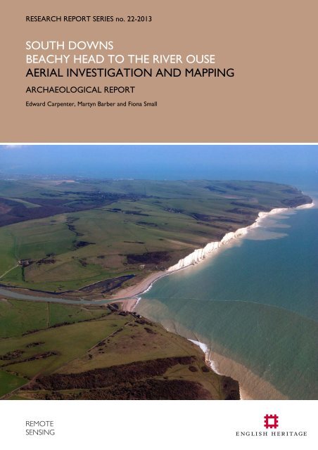
Cover Photograph: Cuckmere Haven, the Seven Sisters <strong>and</strong> Beachy Head.TV 5197/10 08-MAR-2007 © <strong>English</strong> <strong>Heritage</strong>
SUMMARYThis survey involved the interpretation, transcription <strong>and</strong> recording of all archaeologicalfeatures seen on aerial photographs for part of the South Downs within East Sussex. Theproject area included the coast from Peacehaven to the western edge of Eastbourne,areas of downl<strong>and</strong> <strong>and</strong> parts of the Ouse <strong>and</strong> Cuckmere river valleys. This reportexplores some of the key themes identified during the project.This survey is one of three projects designed to characterise the historic environment insample areas of the South Downs National Park (see Carpenter 2008, Young 2011). Theresults also complemented the South East Rapid Coastal Zone Assessment Survey(Hamel & Lambert 2011; Dickson, Janik, Priest & Royall 2012).The project contributed toNational <strong>Heritage</strong> Protection Plan (NHPP) Measure 3 Activity 3A4 Identification ofterrestrial assets via non-intrusive survey (RASMIS Project Number 5868 NMP S Downs).The project recorded 655 previously unknown archaeological features <strong>and</strong> amendeddetails for 265 in the <strong>English</strong> <strong>Heritage</strong> National Record of the Historic EnvironmentArchaeological features were recorded with potential dates ranging from the Neolithicthrough to the modern period. Extensive areas of lyncheted field systems highlight thepossibility of, as yet undiscovered, associated enclosed settlements <strong>and</strong> the need tocarefully consider the relationships of the fields to Bronze Age round barrows <strong>and</strong> otherfeatures on the Downs. Perhaps one of the most iconic features of this part of the Downsis the Long Man of Wilmington. This hill figure is discussed <strong>and</strong> its relationship to thenearby earthworks whose perceived antiquity influenced the dating of the Long Man.Dewponds <strong>and</strong> a livestock enclosure are testament to the sheep kept on the downs.Numerous works were undertaken to improve both the drainage of the Ouse valley <strong>and</strong>the navigation of the river itself <strong>and</strong> evidence of earlier episodes of these works wereidentified. There is good evidence of the First World War army camps at Seaford, <strong>and</strong>extensive military remains dating to the Second World War. These reflect both the threatof attack from the air or invasion as well as the widespread military training undertakenacross much of the downs. Representations of wartime Newhaven on aerial photographs<strong>and</strong> in war art are discussed.CONTRIBUTORSThe interpretation, transcription <strong>and</strong> recording were carried out by Edward Carpenter,Fiona Small, Martyn Barber, Robert Skinner, <strong>and</strong> Cathy Stoertz. Edward Carpenter, MartynBarber <strong>and</strong> Fiona Small wrote the report. Helen Winton compiled <strong>and</strong> edited the report<strong>and</strong> produced some of the illustrations.ACKNOWLEDGEMENTSThanks to Luke Griffin <strong>and</strong> the <strong>English</strong> <strong>Heritage</strong> Archive Services team for supplying theexceptionally large numbers of photographs. Thanks to Gregory Chuter <strong>and</strong> staff at EastSussex County Council for information, help <strong>and</strong> advice. Thanks to Richard Beckett,Newhaven Historical Society for information regarding wartime Newhaven. Thanks toMargaret Thorburn for the kind gift of her publication on the Ouse Valley. Finally, thanksto Alun Martin, librarian of the Cambridge University Collection of <strong>Aerial</strong> Photography forthe loan of their photographs.© ENGLISH HERITAGE 22-2013
ARCHIVE LOCATION<strong>English</strong> <strong>Heritage</strong>,The Engine House,Fire Fly Avenue,Swindon,SN2 2EHDATE OF SURVEY2009-10 & 2012CONTACT DETAILSHelen Winton<strong>Aerial</strong> <strong>Investigation</strong> & <strong>Mapping</strong>,<strong>English</strong> <strong>Heritage</strong>,The Engine House,Fire Fly Avenue,Swindon,SN2 2EHwww.english-heritage.org.uk/aerialsurvey© ENGLISH HERITAGE 22-2013
THE LONG MAN OF WILMINGTON ...................................................................................65Description of the current Long Man ..................................................................................................................66Legs, feet <strong>and</strong> photographs.....................................................................................................................................68Rake, scythe, crown, cock <strong>and</strong> face......................................................................................................................71Shifting outlines.........................................................................................................................................................72Old by association....................................................................................................................................................72Windover Hill ‘Flint Mines’.....................................................................................................................................76The ‘Roman’ terrace-ways......................................................................................................................................81The Long Man <strong>and</strong> the quarries: discussion........................................................................................................83REFERENCES..................................................................................................................................88© ENGLISH HERITAGE 22-2013
Figure 1 Revised project area.......................................................................................................................................2Figure 2 Archaeological features mapped from aerial photographs.....................................................................3Figure 3 <strong>Mapping</strong> conventions......................................................................................................................................5Figure 4 Toms’ 1920 ‘corrected’ survey....................................................................................................................7Figure 5 Toms’ 1920 survey <strong>and</strong> EH plot from aerial photographs including the long barrow, roundbarrows <strong>and</strong> twentieth century military defences. .........................................................................................9Figure 6 Toms’ 1920 survey of the mound he ‘discovered’ on Windover Hill. ..............................................10Figure 7 1995 oblique view showing relationship of the long mound to the quarry earthworks. ..............11Figure 8 1925 vertical of the Windover Hill area.. ................................................................................................12Figure 9 Hunter’s Burgh. .............................................................................................................................................14Figure 10 Long mound at Exceat.. .............................................................................................................................16Figure 11 Cropmarks near Rathfinny Farm mapped from aerial photographs.. ..............................................17Figure 12 General view of the eastern side of the project area showing the distribution of field systems<strong>and</strong> other archaeological features.. ..................................................................................................................20Figure 13 Field systems <strong>and</strong> round barrows at Heathy Brow <strong>and</strong> above Holwell..........................................21Figure 14 Field systems <strong>and</strong> round barrows at the western end of Heathy Brow <strong>and</strong> above East Deanboth near Beachy Head. .....................................................................................................................................22Figure 15 Field systems across Ewe Dean Down, Old Kiln Bottom <strong>and</strong> adjacent areas...............................23Figure 16 1925 vertical aerial photograph of the field system on Ewe Dean Down......................................24Figure 17 Detail of field system on Ewe Dean Down...........................................................................................26Figure 18 Evidence of medieval or post medieval ploughing, in the form of strip lynchets, on steep slopesof the coombes above Piddinghoe <strong>and</strong> the Ouse Valley. ............................................................................28Figure 19 The Bible’ sheep enclosure.......................................................................................................................30Figure 20 Medieval <strong>and</strong> post medieval embankments at Iford <strong>and</strong> Rodmell. ...................................................34Figure 21 Embankments flanking a former me<strong>and</strong>er in the River Ouse............................................................35Figure 22 An early example of by-passed me<strong>and</strong>er in the River Ouse to the west of South Heighton. ...36Figure 23 Extents of South Camp..............................................................................................................................40Figure 24 Suggested layout of North Camp............................................................................................................41Figure 25 <strong>Aerial</strong> photograph of part of North Camp. ..........................................................................................42Figure 26 Earthwork remains of First World War training trenches on Ewe Down. ...................................43Figure 27 Belle Tout <strong>and</strong> Shooter’s Bottom tank training ranges. .....................................................................45Figure 28 Evidence of tank training in the Cuckmere Valley...............................................................................46Figure 29 Second World War anti-l<strong>and</strong>ing obstructions between Seaford <strong>and</strong> the Cuckmere River .......49Figure 30 Diver anti-aircraft gun emplacement on Crapham Down. ................................................................52Figure 31 Friston Airfield – a Second World War emergency l<strong>and</strong>ing ground...............................................53Figure 32 L<strong>and</strong>ing craft at Sleeper’s Hole, Newhaven 1943.. ..............................................................................54Figure 33 Trenches <strong>and</strong> barbed wire defending the westward approach to Newhaven...............................56Figure 34 SS Davaar blockship moored at the mouth of Newhaven Harbour in 1942.................................57© ENGLISH HERITAGE 22-2013
Figure 35 Britannia needs no bulwarks, later renamed Coastal Defences 1. Newhaven, painted 1940. ByPermission of IWM (Imperial War Museums)...............................................................................................58Figure 36 Coastal Defences. Newhaven, painted autumn 1940. By Permission of IWM (Imperial WarMuseums)...............................................................................................................................................................59Figure 37 Fuel oil storage tanks in Meeching Quarry............................................................................................62Figure 38 Camouflage netting concealing a storage tank <strong>and</strong> possible magazines near West Quay.Figure 39 Newhaven’s wartime battery camouflaged with netting. ...................................................................63Figure 40 Camouflage netting over the River Ouse north of Newhaven.........................................................64Figure 41 Moored barrage balloons <strong>and</strong> breached sea defences at Newhaven...............................................64Figure 42 The Long Man amidst the earthworks of chalk <strong>and</strong> flint extraction................................................65Figure 43 The Green Man of Wilmington, as photographed during the war...................................................66Figure 44 Annotated extract from 1925 vertical showing locations of alleged flint mines <strong>and</strong> ‘Roman’trackways...............................................................................................................................................................74Figure 45 Location of alleged flint mines either side of the Long Man..............................................................77Figure 46 Tracks initially identified by Toms, Curwen <strong>and</strong> others as Roman..................................................81© ENGLISH HERITAGE 22-2013
INTRODUCTIONThis report describes the results of The South Downs NMP: Beachy Head to River OuseProject. This forms part of a suite of <strong>English</strong> <strong>Heritage</strong> research to enhance ourunderst<strong>and</strong>ing of the archaeological remains within the area covered by the newly createdSouth Downs National Park (McOmish 2005). It is the third project in the park to useNational <strong>Mapping</strong> Programme (NMP) st<strong>and</strong>ards following-on from Hampshire SouthDowns (Young 2011), <strong>and</strong> The South Downs NMP Pilot Area 1: Worthing to the Weald(Carpenter 2008). These projects were carried out to characterise the archaeology onthe Downs <strong>and</strong> immediate environs <strong>and</strong> to inform future archaeological work <strong>and</strong>conservation management plans for the National Park.The project contributed to National <strong>Heritage</strong> Protection Plan (NHPP) Measure 3 Activity3A4 Identification of terrestrial assets via non-intrusive survey (RASMIS Project Number5868 NMP S Downs).All archaeological features visible on aerial photographs were surveyed <strong>and</strong> recorded. Thisincluded buried features visible as cropmarks or soilmarks, earthworks <strong>and</strong> structures witha potential date range from the Neolithic period to the mid-20th century, the lattermainly military sites.The project area originally comprised chalk downl<strong>and</strong> between Lewes <strong>and</strong> Eastbourne,the Ouse <strong>and</strong> Cuckmere river valleys, <strong>and</strong> part of the Weald (Carpenter 2009). Itincluded the eroding ‘heritage coastline’ at Beachy Head <strong>and</strong> an area for proposedmanaged retreat along the lower Cuckmere river (EA 2007).The coastal strip was completed in 2010 to contribute to the South East Rapid CoastalZone Assessment Survey EH Projects No. 5698, 6102-3 (Hamel <strong>and</strong> Lambert 2011,Dickson et al 2012). The World War I camps at Seaford were subject to further analysisas part of this phase (Skinner 2011). The interim results contributed to a website on theSouth Downs http://www.english-heritage.org.uk/discover/south-downs/Due to a reduction in the team, the project was revised to target key areas ofarchaeological <strong>and</strong> geographic significance (Small <strong>and</strong> Winton 2012). The revised projectarea comprised 118 square kilometres. The reduced area, chosen by the project team<strong>and</strong> stakeholders, included Bullock Down, part of Friston Forest, the Ouse <strong>and</strong> Cuckmerevalleys, <strong>and</strong> the areas of chalk downl<strong>and</strong> east of Lewes <strong>and</strong> between Beachy Head <strong>and</strong>the Long Man of Wilmington. The remaining parts of the revised project area werecompleted in Late 2012.The project recorded 655 previously unknown archaeological features <strong>and</strong> amendeddetails for 265 in the <strong>English</strong> <strong>Heritage</strong> National Record of the Historic Environment(NRHE AMIE database).© ENGLISH HERITAGE 1 22 - 2013
Project AreaThe project area is in East Sussex <strong>and</strong> includes downl<strong>and</strong> to the east of Lewes, the OuseValley below Lewes, a coastal strip between Newhaven <strong>and</strong> Eastbourne, the CuckmereValley up to Berwick, <strong>and</strong> downl<strong>and</strong> stretching north-west from Beachy Head toWilmington (Fig 1). The area is within the eastern end of the South Downs National Parkexcept the coastal towns of Seaford, Newhaven <strong>and</strong> Peacehaven.Figure 1 Revised project area outlined in pink, original area in yellow. Background mapping © Crowncopyright <strong>and</strong> database right 2013, all rights reserved. Ordnance Survey Licence number 100024900.The coast between Seaford <strong>and</strong> Beachy Head is defined, by Natural Engl<strong>and</strong>, as a‘<strong>Heritage</strong> Coast’. These are areas of coastline managed to conserve <strong>and</strong> enhance thenatural beauty <strong>and</strong> public enjoyment, underst<strong>and</strong>ing <strong>and</strong> appreciation. The area also fallswithin the Natural Engl<strong>and</strong> Joint Character Area 125 – South Downs. This area is similarin extent to the National Park <strong>and</strong> covers the chalk downl<strong>and</strong> between Winchester <strong>and</strong>Eastbourne. Natural Engl<strong>and</strong> describe it as ‘a chalk l<strong>and</strong>scape of high exposed rolling hills,steep scarps, rounded open ridges <strong>and</strong> dry valleys (combes)’ where ‘rivers from the Low© ENGLISH HERITAGE 2 22 - 2013
Weald cut through the Downs forming river valleys <strong>and</strong> broad floodplains’ (source:Natural Engl<strong>and</strong> website).The underlying geology in most of the survey area is chalk. Most of the project areatherefore has shallow well drained calcareous silty soils over chalk of the Andover 1 SoilAssociation. There are pockets of well drained fine loamy over clayey, <strong>and</strong> clayey, soils ofthe Marlow Soil Association. These soils extend along the higher ridges on the chalkdowns, to the south of Friston Forest, for example. The soils in the river valleys mainlycomprise marine alluvium of the Newchurch 1 <strong>and</strong> 2 Soil Associations with river alluviumin the upper reaches beyond Litlington in the Cuckmere valley <strong>and</strong> above Beddingham<strong>and</strong> Lewes in the Ouse valley.Figure 2 Archaeological features mapped from aerial photographs. Background mapping © Crowncopyright <strong>and</strong> database right 2013, all rights reserved. Licence number 100024900.There appears to be no correlation between geology or soil type <strong>and</strong> the distribution ofarchaeological features recorded. Archaeological features were recorded on all soil typesalthough the distribution of types of archaeology varied (Fig 2).© ENGLISH HERITAGE 3 22 - 2013
During the 19 th <strong>and</strong> first half of the 20 th century, the South Downs were noted for theirunenclosed rolling l<strong>and</strong>scape <strong>and</strong> abundant flora, characteristics dependent on the grazingof sheep. Archaeological earthwork preservation was relatively good up until the late1940s <strong>and</strong> some of these archaeological sites contributed to the popular image of theSouth Downs as an unspoilt, unchanging l<strong>and</strong>scape that offered a haven from modern life.The expansion of ploughing across the Downs since the Second World War has changedthe l<strong>and</strong>scape <strong>and</strong> levelled many archaeological earthworks. Between the wars, thegrowing desirability of the Downs as a place to live resulted in house building in someparts <strong>and</strong> some areas such as Peacehaven were developed. Conservation bodies, includingthe National Trust, purchased l<strong>and</strong> to protect this apparently threatened l<strong>and</strong>scape.Although the initial proposal for a South Downs National Park was rejected immediatelyafter the Second World War, it was designated in 2009.MethodsThe project scope included all archaeological features visible on aerial photographs. Theseranged in date from the Neolithic period to the 20th century <strong>and</strong> included sites visible ascropmarks <strong>and</strong>/or earthworks but also structures, in particular those relating to earlytwentieth century military activities. All aerial photographs from the <strong>English</strong> <strong>Heritage</strong>Archive (formerly the National Monuments Record (NMR)), Cambridge University, <strong>and</strong>East Sussex Historic Environment Record (HER) were consulted. All vertical photographicprints were viewed using a stereoscope. Readily available documentary sources (historicmaps etc) <strong>and</strong> synthesised background information on the area (published material,NRHE <strong>and</strong> HER monument records) were also consulted.Rectified <strong>and</strong> georeferenced digital images were produced by transforming scans ofoblique <strong>and</strong> vertical photographs using the University of Bradford AERIAL5 programme.Control information was taken from digital 1:2500 scale Ordnance Survey Mastermapdata. The relevant scanned photograph(s) were usually rectified to an average level ofaccuracy of 2m or less to the base map. This gives an overall accuracy of plotted features,to true ground position, dependent on the accuracy of the map base, usually guaranteedby the OS to be within ±5-15m. A digital terrain model function, using OS 5m intervalcontour data, was used to compensate for undulating terrain.Archaeological features were traced from georeferenced <strong>and</strong> rectified photographs usingAutoCAD Map (Fig 3). Archaeological features were depicted on different layers basedon the form of remains (For example bank, ditch etc). A monument polygon was createdfor each site. Basic indexing information (For example period, monument type, photoreference) was attached to groups of objects, in AutoCAD, to aid analysis of the mapping.A unique identifier number was attached to each group of objects corresponding to themonument description in the <strong>English</strong> <strong>Heritage</strong> AMIE database.© ENGLISH HERITAGE 4 22 - 2013
Monument records in the NRHE AMIE database were created or amended whereappropriate. The project recorded 655 previously unknown archaeological features <strong>and</strong>amended details for 265 records.The monument record consisted of a textual description of the site linked to indexedlocation, period, type <strong>and</strong> form of evidence. The record also included digital crossreferences to other monuments <strong>and</strong> datasets (usually the HER or scheduling information)as well as a list of the main aerial photographs <strong>and</strong> other sources for the site. An Eventrecord in the NRHE AMIE database was created to provide data on project scope <strong>and</strong>procedures. Archive records were created for each quarter sheet. The Event <strong>and</strong> archiverecords are linked to each monument record.All data <strong>and</strong> documentation relating to the project was archived at the <strong>English</strong> <strong>Heritage</strong>Archive (formerly the National Monuments Record). Full monument records are availablevia Pastscape (www.pastscape.org.uk). <strong>Mapping</strong> <strong>and</strong> monument records are available onrequest from the <strong>English</strong> <strong>Heritage</strong> Archive Services. All data was supplied to the EastSussex HER.DitchLevelled Ridge & FurrowBankExtant Ridge & FurrowStructure (e.g Buildings)Large Area FeatureLarge cut feature e.g. quarrySlopeFigure 3 <strong>Mapping</strong> conventions.© ENGLISH HERITAGE 5 22 - 2013
NEOLITHIC LONG BARROWSIn the absence of either causewayed enclosures or flint mines from the project area, theearliest monuments encountered are a series of probable or possible Neolithic longbarrows: Money Burgh (AMIE: 406246), Camel’s Humps (406570), Windover Hill(408708), Hunter’s Burgh (408732), Litlington (408791), <strong>and</strong> Exceat (470226). A possiblenew discovery was seen as cropmarks at Rathfinny Farm (1568872). Further long barrowslie just outside the project area, for example: Long Burgh (408646); Alfriston (408685);<strong>and</strong> Firle Beacon (405738).Although the Sussex long barrows featured prominently in explanatory models for thedevelopment of the Neolithic across the South Downs (For example Drewett 1978,2003; Russell 2001, 2002), there has been surprisingly little fieldwork undertaken on them.Sussex’s causewayed enclosures <strong>and</strong> flint mines, many of which were discovered duringthe inter-war years, have seen many episodes of investigation during the 20 th century.However, the only East Sussex long barrow to be excavated was the mound at Alfriston(Drewett 1975), located just outside the project area.The first publication dealing specifically with Sussex long barrows was by Herbert Toms,curator of Brighton Museum <strong>and</strong>, in the 1890s, assistant to Pitt Rivers during some of hiskey excavations on his Cranborne Chase estate. Toms’ 1922 paper on the Sussexmounds featured measured surveys of all 5 long barrows known at the time, 3 of them –Money Burgh, Camel’s Humps, <strong>and</strong> Windover Hill (which he discovered shortly aftersurveying the other 4) – located within the project area. Another, Hunter’s Burgh, wasnoted soon after on aerial photographs. The number has risen gradually since then, ofcourse, but one principal feature of long barrow distribution on the Sussex Downs hasremained relatively constant – most lie in the area of downl<strong>and</strong> between Brighton <strong>and</strong>Eastbourne.Perhaps the key development of recent decades was Drewett’s (1975, 1978, 1986 etc)efforts to distinguish a class of ‘oval barrow’ in the wake of his excavations at Alfriston.These, he argued, were shorter than long barrows generally, their mounds – as the namesuggests – more oval than long (or trapezoidal), <strong>and</strong> – on the basis of his excavations atthe Alfriston example <strong>and</strong>, subsequently, North Marden in West Sussex – later in datethan the larger long barrows. Consequently they could be seen as an intermediate stagebetween the long mounds of the earlier Neolithic <strong>and</strong> the round mounds of the BronzeAge. The idea of a distinct class of oval barrows within Sussex has come in for severecriticism (For example Kinnes 1992; Russell 2001, 2002; Field 2006 etc) – barrows ofsimilar dimensions <strong>and</strong> morphology are quite widespread across southern Britain (Forexample the so-called ‘Cranborne Chase Type’), <strong>and</strong> there is no evidence for them beingmarkedly later, either individually or as a class, than any other kind of long barrow.The recent project focusing primarily on the dating of causewayed enclosures, usingBayesian analysis (Whittle et al 2011), noted of long <strong>and</strong> oval barrows in Sussex that© ENGLISH HERITAGE 6 22 - 2013
‘Although there are up to 20…, little is known of them’ (ibid, 243-4), with the lack of anydating evidence meaning that ‘Sussex long <strong>and</strong> oval barrows [are] at present inchronological limbo’ (ibid., 246). Generally speaking it seems that the Sussex flint mineswere potentially the earliest Neolithic monument across the South Downs (perhapsbeginning before 4000BC), with the practice of building long barrows beginning during thefirst half of the fourth millennium BC, probably before the first causewayed enclosures.However, with no dates available, <strong>and</strong> evidence from elsewhere indicating that althoughindividual barrows may have had a use-life of just two or three generations, barrowconstruction was itself quite long-lived, it is impossible to be sure where to place any ofthe Sussex mounds. An added problem is that in the absence of fieldwork <strong>and</strong>, inparticular, excavation, question marks can even be placed against the identification ofsome of the mounds as long barrows.The probable <strong>and</strong> possible Neolithic long barrows within the project area are described inturn below, with details from analysis of aerial photographs compared with earlierdescriptions of the various mounds:Money BurghToms’ 1920 survey showed a mound 118 feet (35.9 metres) long, orientated eastnortheastto west-southwest, with a ‘pronounced eastern end’, i.e. it was higher <strong>and</strong> widerthan the other end (Fig 4). Later investigation by the Ordnance Survey ArchaeologyDivision recorded the mound length as 38 metres, with the eastern end 15.5 metres wide<strong>and</strong> 2 metres high, compared to the western end’s 9.5 metres by 1.75 metres. Toms hadstated (1922, 159) that ‘All trace of lateral ditches has been obliterated by trackways <strong>and</strong>former cultivations, but the present conformation of the ground shows that these ditchesdid not run around the ends’.Figure 4 Toms’ 1920 ‘corrected’ survey (left, from Toms 1922); trace from aerial photography (right)Background mapping © Crown copyright <strong>and</strong> database right 2013, all rights reserved. Ordnance SurveyLicence number 100024900.© ENGLISH HERITAGE 7 22 - 2013
The OS confirmed that there were no traces of ditches visible on the surface.Examination of recent <strong>and</strong> historic aerial photographs also confirms this – all that could bemapped was an elongated mound circa 36 metres by 15 metres, with a markedindentation on the northern side of the western end (Fig 4).In 1922 Toms wrote that ‘this barrow has been badly excavated in quite recent years’,featuring ‘a modern-looking trench, which runs nearly the whole length of the crest’, while‘material from an earlier excavation of the mound has been thrown to the north forminga talus…which, combined with the results of former ploughing, gives the mound a bulgingappearance to the north-east’. This description certainly tallies with the recent aerialphotograph investigation – the apparent discrepancy between the appearance of themound on the latter <strong>and</strong> on Toms’ survey is the result of Toms ‘correcting’ the barrowoutline on his survey (Toms 1922, 159-160).One of the excavations was apparently carried out by a Mr Joseph Tompsett who,according to Toms, ‘died many years ago’. Tompsett’s gr<strong>and</strong>daughter told Toms in 1910that ‘a skeleton <strong>and</strong> other antiquities were found in the upper portion of the mound’, but‘she was of the opinion that the excavation did not reach the level of a primary interment’(Toms 1922, 160). Although Miss Tompsett seemed certain the finds were sent to theSussex Archaeological Society’s museum at Lewes, the museum does not appear to havethem (AS Phillips, OS field investigator, 19 th May 1972 in AMIE record 406246).Camel’s Humps (or Warrior’s Grave, or Cliffe Hill Long Barrow)Toms (1922, 157) referred to this as the Cliffe Hill long barrow, but noted that ‘accordingto Mr JHA Jenner, the tumulus has been named ‘The Camel’s Humps’.’ The name‘Warrior’s Grave’ was reported by Grinsell (1934, 220). Toms’ measured the moundlength as 116 feet (c 35 metres), noting that ‘it has all the characteristics of a long barrow(Fig 5)’. The name ‘Camel’s Humps’ derives from its appearance – as Toms noted, ‘Fromthe top of School Hill, Lewes, this mound looks like two adjacent tumuli, for the reasonthat a large hole…excavated east of its centre, has left the two ends st<strong>and</strong>ing in the formof a camel’s humps’ (ibid). Spoil from this excavation had been thrown outwards,particularly to the south, partly obscuring the line of the southern ditch. Toms reportedthat the north-east <strong>and</strong> south-west ditch terminals were ‘distinctly visible in suitable lights’,while the south-east terminal had ‘been destroyed by some kind of excavation, possiblyfor flints’. The north-west corner of the barrow was occupied by a golf green.Toms’ survey showed a mound orientated east-southeast by west-northwest, with aflanking ditch on either side. The ditches are gently curved, <strong>and</strong> neither show signs ofcontinuing around either end of the mound. Ordnance Survey field investigation in 1972confirmed the existence of a mound measuring circa 34m in length <strong>and</strong> 18m wide, <strong>and</strong>st<strong>and</strong>ing up to 3.2m high, which accords well with Toms’ survey half a century earlier.However, while a ditch – extant up to 0.8m deep – was visible on the north side, ‘on thesouth side it has been destroyed by a golf fairway’.© ENGLISH HERITAGE 8 22 - 2013
Figure 5 Toms’ 1920 survey (left), from Toms 1922; plot from aerial photographs including the longbarrow, round barrows <strong>and</strong> twentieth century military defences (right) Background mapping © Crowncopyright <strong>and</strong> database right 2013, all rights reserved. Licence number 100024900.<strong>Mapping</strong> in 2012, from aerial photographs taken in 1968, did identify the course of at leastpart of the southern ditch, although the mound appears markedly more irregular than inToms’ survey, with a flattened western end (Fig 5). The south-eastern end, where themound appears truncated <strong>and</strong> the ditch terminal missing, fits well with Toms’ account ofthis area having been destroyed by digging.Windover HillThis mound was first identified by Herbert Toms in August 1920 after completing thesurveys of the other four long barrows that featured in his 1922 paper. Toms haddiscovered the mound (although in fact it was depicted on Ordnance Survey maps – seebelow) whilst walking up Windover Hill from the west, the parallel ‘ditches’ of an alleged‘cambered road’ (see below) having caught his eye (Toms 1922, 161-3).Toms admitted to being ‘puzzled’ by the long mound, these initial doubts being promptedby its proximity to the large chalk-pit on the summit of the hill – he does not mention theshallower earthworks of hollows <strong>and</strong> spoil around the mound <strong>and</strong>, indeed, all over the hill.He noted the presence of a ditch – ‘filled up nearly level’ – visible on the surface on thedownhill (northwest) side, which on his survey he showed complete but for a shortstretch towards the south-western terminal. He does not mention the other ditch, but itis shown on his plan, albeit lacking a terminal at its north-eastern end (Fig 6). Toms’ surveyshowed a circular mound a short distance north-east of the long mound – he seems to© ENGLISH HERITAGE 9 22 - 2013
have regarded this as a separate feature, although his account is a little ambiguous. Hecertainly did not regard it as a round barrow, however.The outline of the long mound was already depicted on the 1874 25’ Ordnance Surveymap but, unlike the round barrows a short distance to the east, it was not labelled‘tumulus’, which might imply that the OS surveyors considered it to be associated withthe adjacent chalk quarry. Toms noted that the OS plan of the mound showed it to becirca 250 feet (c 76 metres) long instead of the 180 feet (c 54 metres) that he hadmeasured. The discrepancy, he suggested, was caused by the OS surveyors including ‘therise with the flat top, which my plan shows adjacent to the north-east end of the mound’.Either the OS surveyors ‘reconstructed’ the mound on their survey, ignoring the gap, orthe gap did not exist in 1874. The latter explanation would require quarrying to still begoing on at this late date, which seems unlikely on present evidence, especially as the1874 OS map labels the adjacent quarry ‘old chalk pit’.Figure 6 Toms’ 1920 survey of the mound he ‘discovered’ on Windover Hill (from Toms 1922).Noting that he had traced the course of the ditch on the north-western side beyond theend of the long mound, to a point roughly level with the ‘rise’, Toms did speculatewhether ‘the big mound was not originally as long as this side of the ditch, the rise havingbeen formed subsequently by traffic or a way cut across the north-east end’ (ibid, 65). Hewas, at best, unsure – unlike on some of his other long barrow surveys, he did not‘restore’ the outline on the plan to include this ‘rise’, nor did he include it in any of hisprofiles <strong>and</strong> sections. As noted above, he referred to it as a ‘rise with a flat top’, <strong>and</strong> hissurvey plan shows a roughly circular mound, its flat top some 20 feet (c 6 metres) indiameter. He noted that when ‘st<strong>and</strong>ing on this rise, one looks down the very steepescarpment on to the ‘Long Man’…’ (ibid).© ENGLISH HERITAGE 10 22 - 2013
Subsequent survey by the Ordnance Survey Archaeology Division seems to havecontinued the OS tradition of regarding both features as part of a single mound. In 1972,Keith Blood recorded a mound 68 metres long, circa 13 metres wide <strong>and</strong> up to 2 metreshigh, ‘with flanking ditches visible as vegetation marks’. He added that ‘The barrow ismutilated towards its NE end by an old track crossing it, giving the erroneous impressionof two mounds’.Figure 7 1995 oblique aerial view showing the relationship of the long mound to the quarry earthworks.Note how the suggested round mound or ‘flat-topped rise’ is actually integral to the latter. NMR15211/23, 30 January 1995 © Crown Copyright. <strong>English</strong> <strong>Heritage</strong>.The earthworks on Windover Hill were re-examined by Royal Commission on theHistorical Monuments of Engl<strong>and</strong> (RCHME) staff in 1995 in the course of a projectfocused on Neolithic flint mine sites. Some of the earthworks on Windover Hill had beenidentified in the mid-1920s as being flint mines. The RCHME visits confirmed that thesupposed Neolithic flint mines were actually quarries of much more recent date (see alsothe chpater below on the Long Man). The RCHME team recognised the implications forthe date of the long mound. In his book Earthen Long Barrows, Dave Field, one of theRCHME staff who had visited the area in 1995, wrote as follows:‘The large mound on Windover Hill in Sussex reaches 68m in lengthwith a level summit at a height of 2m… It is surrounded by an area ofchalk quarries <strong>and</strong> a cambered feature once thought to be a RomanRoad leads upslope directly towards it. Inspected in greater detail by the© ENGLISH HERITAGE 11 22 - 2013
[RCHME] in recent years, the road is undoubtedly a tramwayassociated with the quarry <strong>and</strong> the long barrow a terminal associatedwith it. It remains possible that the quarry workers modified <strong>and</strong> utilisedan existing mound, but they could easily have constructed a br<strong>and</strong> newone. Unfortunately, there is little direct evidence that this should be so<strong>and</strong> extreme caution is now required regarding its true classification.Only excavation to test the nature of the mound will confirm the point’(Field 2006, 24).’Figure 8 1925 vertical of the Windover Hill area. North to right. TQ 5403/5 OSV 11241/42590 6thOctober 1925 <strong>English</strong> <strong>Heritage</strong>. Ordnance Survey Collection.Miles Russell (2001, 65) had already questioned the RCHME view, insisting that ‘There isno reason to doubt the primary interpretation of the Windover mound…especiallyconcerning its position, form, <strong>and</strong> presence of flanking ditches, even if it had beenmodified or reused at some later point during the extraction of subsurface flint.Unfortunately no detailed archaeological investigation into the mound has yet beenconducted.’© ENGLISH HERITAGE 12 22 - 2013
The evidence from aerial photographs equally raises questions about the mound withoutoffering any clear-cut answers. On a vertical aerial photograph taken for the OS inOctober 1925, the angle of sunlight means that the long mound is relatively indistinct,with just a small area of shadow visible at its north-eastern end (Fig 8). The possibleextension – Toms’ flat-topped rise – is easier to pick out. The long mound seems a littleless regular than depicted by Toms – his plan showed a very straight mound with a slightlyoff-centre narrow, flat summit <strong>and</strong> straight, parallel flanking ditches with no sign of a bermseparating them from the mound. On the aerial photograph, the south-eastern flank ofthe mound has a path or track running alongside it. This track comes in from the south,curving as it heads towards the mound, <strong>and</strong> eventually joins the track separating the longmound from its possible extension just east of the latter. The course of the other ‘ditch’ isless distinct in 1925, but on more recent photographs, for example the RCHME 1995colour obliques (such as Fig 7 above), there is again the possibility of a path or trackrunning alongside the mound into the area of quarrying. Of course, the presence of tracksdoes not rule out the prior existence of ditches either side of the mound but they dooffer an alternative reason for a slightly hollowed area alongside it.Other aerial photographs also suggest that the long mound itself is not quite as straight oras flat-topped as on Toms’ survey. Shadows present on the 1925 <strong>and</strong> 1995 aerialphotographs mentioned above plus, for example, RCHME obliques from 1977 suggestthat the south-western end may be a sub-circular feature on a slightly different alignmentfrom the rest of the mound, with a slight fall in height between it <strong>and</strong> the continued lineof the long mound to the northeast. Meanwhile, the ‘flat-topped rise’, rather than being anorth-eastern extension of the long mound, separated from the rest of the latter by atrackway, appears more closely integrated with the hollows <strong>and</strong> spoil of the quarries thatextend eastwards from the so-called western group of mines, across the top of the scarp.It is noticeably wider than the long mound, <strong>and</strong> is also markedly off-centre in relation tothe long axis of the latter. In fact, on the verticals especially, the long mound <strong>and</strong> the ‘rise’look to be two separate constructions rather than a single feature cut through by a path.While there is a possibility that a path heading along the terrace, past the entrance to thelarge quarry, has been cut through an existing long mound, going round it – along one ofthe other paths or tracks, perhaps – might have presented a simpler option. Finally, giventhe impact of chalk quarrying on chalk-built long barrows elsewhere, For exampleWinterbourne Stoke, Wiltshire; Dampney Barrow, Damerham, Hampshire (Barber &Wickstead in press), the possible survival – relatively unscathed – of a long barrow amidstchalk quarrying on Windover Hill is worth noting.Hunter’s BurghThis mound was first noted on a set of 1925 verticals taken by the Aircraft OperatingCompany for the Ordnance Survey as part of an experiment in mapping from aerialphotographs over more varied terrain than had been attempted previously (Barber 2011,143; 2013). Some of the photographs contained detail that the Ordnance Survey’sArchaeological Officer, OGS Crawford, felt warranted further attention, <strong>and</strong> he passed a© ENGLISH HERITAGE 13 22 - 2013
set of prints on to Sussex-based field archaeologist Cecil Curwen. The mound wasn’tentirely a new discovery – the name Hunter’s Burgh is attested at least as early as 1579(Mawer <strong>and</strong> Stenton 1930, 414), <strong>and</strong> the barrow is depicted on Ordnance Survey maps,but as a round barrow.Figure 9 Hunter’s Burgh seen on an enlarged extract from RAF/58/2321/0044 2nd December 1957<strong>English</strong> <strong>Heritage</strong> RAF Photography.Curwen was the first to publish a note of the discovery, in his 1928 paper on TheAntiquities of Windover Hill. A little over 800 metres east-northeast of the Windover Hillmound, Curwen (1928, 93-5) described it as ‘situated on falling ground <strong>and</strong> [it] measures190 ft [c 58 metres] by 75 ft [c 22.9 metres], the long axis pointing a little east of north,<strong>and</strong> the south end being the wider. This south end has been dug into at some periodsubsequent to its construction, <strong>and</strong> the upcast soil, having been scattered radially roundthe excavation, has given the whole mound something of the appearance of a cuppedround barrow with a long tail pointing northwards. There are wide hollows, rather th<strong>and</strong>itches, along the two flanks of the mound <strong>and</strong> also round the south end, but not at thenorth end.’ Ordnance Survey field investigation in 1972 confirmed Curwen’s description,although differing on size – 64 metres north-south, by 18 metres east-west, <strong>and</strong> 2 metreshigh at the higher southern end. The ditch was ‘discernible as a vegetation mark on the W<strong>and</strong> S side but nothing remains of the E ditch’.On recent aerial photographs ( For example PGA TQ5403 28 th June 2004) it has theappearance of a circular mound c 15 metres in diameter with a long tapering tail headingoff from its northern side. The hollow in the top of the southern end only serves tounderline this resemblance to an excavated round barrow. Its total length, as mappedfrom aerial photographs, is around 61 metres – this is only approximate, as although thesouthern end seems quite well defined, at the northern end it seems to fade outsomewhat. Its width is also difficult to determine (Fig 9). As Curwen noted, a ditch, visible© ENGLISH HERITAGE 14 22 - 2013
on aerial photographs as differential grass growth, does seem to run along the western(uphill) side <strong>and</strong> curve around the southern end, but the situation on the eastern, downhillside is less clear, <strong>and</strong> is not helped by the presence of a path.The mound looks most convincing as a long barrow on the 1925 vertical used by Curwen– it appears as a roughly wedge-shaped mound, perhaps slightly wider in the middle thanat the southern end, <strong>and</strong> tapering away to the north. Later verticals (Fig 9), with low sunshining from the south, underlines the distinction between the higher, more or lesscircular end, <strong>and</strong> the long, lower mound on its northern side. Clearly further work on theground is necessary to determine whether this is a long barrow, a round barrow, or both.LitlingtonThe Ordnance Survey recorded two mounds at Litlington – one (AMIE: 408794) at TQ53550060, the other (AMIE: 408791) at TQ 53560065. Russell (2001, 59) suggested thatboth records may refer to the same mound. However, the two records are based on twodistinct, albeit doubtful, features recorded by Leslie Grinsell but clearly, some confusionhas arisen at some stage over the two. One – 408791 – was recorded by Grinsell as ‘along mound which has the appearance of a long-barrow’ (1930, 69); the other – 408794– as a doubtful bowl barrow (Grinsell 1934, 273). Somewhere along the line, for reasonsthat are unclear, the latter became re-classified in the OS (or RCHME) records as an ovalbarrow.Grinsell recorded the long mound at a location described as ‘about 600 yards south ofManure Barn, Litlington Parish’ – his siting is only approximate as at this stage Grinsell wasnot providing grid references – the OS sheets he was using at this stage lacked a grid. Henoted it as being ‘overgrown with trees, gorse <strong>and</strong> shrubs, of various kinds, <strong>and</strong>measurements are consequently difficult’ (Grinsell 1930, 69). Four years later, hedescribed it – in his list of Sussex long barrows – as measuring 28 paces long, 16 paceswide <strong>and</strong> up to 4 feet high. He could see no surface trace of any ditch, <strong>and</strong> suggested thatit may be orientated SW-NE, but could not be sure. He described the mound as ‘oval,possibly doubtful’ (Grinsell 1934, 220). Later Ordnance Survey field investigation met withmixed results – in 1972 Keith Blood noted ‘Traces of a mound up to 1.0m high, soovergrown with scrub, brambles, nettles, etc, that neither its size, nor shape can beascertained. More precise classification impossible’.The monument was scheduled in January 1979 (List Entry Number 1014385). The entrydescribes it as a low earthen mound, oval in shape <strong>and</strong> up to 0.5m in height, orientatedsouth-west – north-east, <strong>and</strong> measuring some 24m long by 16mwide, although the widthwas said to be partly due to the spread nature of the mound through erosion. No surfacesign of the ditches could be seen. Inspection of aerial photographs in 2012 was lessfortunate – the site of the mound could not be identified at all. On early photographs, thelocation was generally obscured by clumps of gorse or bushes; aerial photographs taken in© ENGLISH HERITAGE 15 22 - 2013
The mound is clearly visible on the 1947 RAF verticals. It is orientated approximatelynorthwest-southeast, <strong>and</strong> is located just below the crest of a chalk spur, overlooking theCuckmere valley to the northwest, west <strong>and</strong> south. It is close to the corner of a field, awall passing close by on its northeast-facing long side before curving round to thesouthwest. The shadow cast by the wall make it impossible to determine whether themound is indeed cut by the wall on its north eastern side, or if the mound has spread upto <strong>and</strong> against the wall. In 1947, the l<strong>and</strong> the other side of the wall is pasture, but onmore recent photography it comprises woodl<strong>and</strong> right up to the wall.The mound is extremely difficult to identify in later photography – the low sunlightevident on the RAF photographs is generally lacking. However, a low mound of broadlysimilar shape <strong>and</strong> size can just be made out on Google Earth imagery dating between2004 <strong>and</strong> 2009. Again, the relationship between mound <strong>and</strong> wall is difficult to resolve, butif the wall does cross the mound, very little of the latter could be on the woodl<strong>and</strong> side. Itis also worth highlighting that both the 1947 verticals <strong>and</strong> the 2005 Google Earthphotography show a much slighter linear rise – perhaps a low bank or series of banks –sharing the orientation of the mound <strong>and</strong> running roughly parallel to the field wall to thesoutheast of the mound.Rathfinny FarmFigure 11 Cropmarks near Rathfinny Farm mapped from aerial photographs. Background mapping ©Crown copyright <strong>and</strong> database right 2013, all rights reserved. Licence number 100024900.© ENGLISH HERITAGE 17 22 - 2013
Although just outside the project area, this feature was mapped because of its potentialsignificance (Fig 11). Identified on aerial photographs taken in 1977, it comprises anincomplete sub-rectangular ditched enclosure which appears to be partly overlain by aring ditch, the latter presumably representing a plough-levelled Bronze Age round barrow.The enclosure presents a much fainter cropmark than the ring ditch, the lines of theditches also being incomplete on the available photographs, <strong>and</strong> is aligned WNW-ESE,measuring approximately 39 metres long, <strong>and</strong> tapering in width from 15.7 metres acrossits south-east end to 12 metres across its north-western end. Presuming it is earlier thanthe ring ditch, then a Neolithic date is possible. The rectilinear arrangement would beunusual but not unknown for a long barrow; alternatively it may represent a monument ofthe form usually referred to as ‘mortuary enclosures’ or ‘mortuary structures’.Long barrows - discussionThere is very little known about the long barrows in the project area <strong>and</strong> the few thatwere subject to early excavation lack any meaningful record of what was found.Consequently, identification must be based on morphological considerations. On thisbasis, both Money Burgh <strong>and</strong> the Camel’s humps look the most convincing cases. Hunter’sBurgh may be a round barrow, a long barrow, or both. The mound on Windover Hill maybe no more than a few centuries old. The sites at Litlington <strong>and</strong> Exceat are clearly in needof further investigation to confirm that they are archaeological features – geophysicalsurvey aimed at identifying ditches would be a useful starting point. Similarly the newdiscovery at Rathfinny Farm requires further investigation to confirm, first of all, that it isindeed earlier than the ring ditch.There are other aspects of Sussex’s long barrows that have been much discussed inrecent years, including their l<strong>and</strong>scape context <strong>and</strong> setting. These would probably be bestaddressed by visiting all the sites on the ground within a study that takes in far more sitesthan those in the project area. Further work should address issues such as Litlington’slocation on a relatively gentle slope above a shallow coombe, or Windover Hill’sorientation – perpendicular to the scarp edge. Additionally, the matter of oval barrows,despite the doubts expressed in the published literature, might benefit from a wider study.© ENGLISH HERITAGE 18 22 - 2013
FIELD SYSTEMSThe Sussex Downs have long been associated with the study of lyncheted field systems.The existence of earthworks representing prehistoric <strong>and</strong> Roman cultivation wasdemonstrated by the Curwens in Sussex (Curwen <strong>and</strong> Curwen 1923) via a good deal ofearthwork survey. This was at the same time as, <strong>and</strong> independently of, OGS Crawford(1923; 1924), who arrived at broadly the same conclusions using aerial photographs(‘checked <strong>and</strong> supplemented by a good deal of fieldwork’ – Crawford 1924, 10) of siteson the chalk downl<strong>and</strong> of Hampshire, Wiltshire <strong>and</strong> Dorset (see also Bradley 1989 for thecontribution of Herbert Toms, <strong>and</strong> Blaker 1902 for an example of earlier work on‘ancient cultivations’ in Sussex). It was Crawford who introduced the term ‘Celtic fields’,which despite the problematic reasoning behind the choice (Wickstead 2008), has provedquite durable.Such field systems are now thought to have been created <strong>and</strong> used over a much longertime period than either Crawford or the Curwens originally envisaged, spanning at leastfrom the Early Bronze Age through to the Romano-British period. However, the dating ofindividual lynchets, fields or even entire field systems remains difficult, as Drewett noted inthe report on the Bullock Down survey (Drewett 1982, 208-9). On the basis of trenchesacross several lynchets in the course of that particular project, dating either the origins orab<strong>and</strong>onment of such systems proved difficult. This led to rather generalised conclusionssuch as ‘it would appear that the lynchet developed during the Late Bronze Age to earlyRoman period at least’ (ibid, 999), but given the proven Middle Bronze Age origins oflyncheted field systems elsewhere on the Downs, an earlier origin would be impossible torule out. Of course, this is not a problem unique to the South Downs.Identifying settlement associated with field systems is equally tricky. A number of wellknownsites elsewhere on the Sussex downs – Black Patch, Itford Hill, <strong>and</strong> so on –featured house sites that survived as slight earthworks, terraced into the hillside. Enclosedsettlements are, of course, a little easier to spot, but do not necessarily date the fields –perhaps the best-known case is South Lodge, Wiltshire, excavated by Pitt Rivers in thelate 19 th century. There, the sub-rectangular enclosure sat within a lyncheted field system,but the enclosure earthworks proved to be enhancements of existing lynchets – the fieldsystem had already been in existence when the enclosure earthworks were constructed.It is difficult to point to any clear cases of enclosed settlements among the fields plottedduring this project.Unenclosed settlements are also difficult to identify, although as was suggested forSalisbury Plain, ‘unusually shaped fields, such as those with curved lynchets or others thatdefine small trapezoidal or triangular areas, might point to the presence of formersettlements set within the fields’ (McOmish et all 2002, 56).© ENGLISH HERITAGE 19 22 - 2013
Figure 12 General view of the eastern side of the project area showing the distribution of field systems<strong>and</strong> other archaeological features mapped from aerial photographs. Note that features in purple relateto 20th century military remains. Background mapping © Crown copyright <strong>and</strong> database right 2013, allrights reserved. Licence number 100024900.In terms of seeking a relative chronology for either the origins or cessation of use for thelyncheted field systems, there is little clear-cut evidence from the project area. This part ofthe South Downs seems to lack, for instance, examples of field systems being slighted bythe construction of later prehistoric linear boundaries, as is seen on Salisbury Plain. At theother end of the chronological spectrum is the relationship between fields <strong>and</strong> earliermonuments. Within the project area, the only type of monument definitely earlier thanthe earliest fields is the long barrow. Only the questionable example at Litlington (seechapter above) is located close to any field boundaries, but the relationship remains© ENGLISH HERITAGE 20 22 - 2013
unclear, especially as the long barrow mound cannot be identified on available aerialphotographs.The relationship of early fields with round barrows offers a different set of problems. Ithas been suggested that field systems may have deliberately incorporated earlierearthworks such as round barrows. However, at the same time there is evidence thatround barrows continued to be built well into the Middle Bronze Age, after theestablishment of the field systems they were associated with, for example Itford Hill,where Ann Ellison distinguished several phases of settlement within a field system, <strong>and</strong>demonstrated that a potsherd from one of the later phases of settlement fitted an almostcomplete vessel recovered from a nearby barrow (Ellison 1978, 36). Further afield, onCranborne Chase, excavation evidence has linked burial monuments with settlementenclosures, the latter appearing some time after the appearance of field systems (Barrettet al 1991, 224-5). Moreover, as new discoveries continue to push the date of the earliestfield systems in southern Engl<strong>and</strong> further back into the early 2 nd millennium BC ( Forexample Martin et al 2012), there is now a considerable chronological overlap betweenround barrows <strong>and</strong> field systems in general.Figure 13 Field systems <strong>and</strong> round barrows at Heathy Brow (left) <strong>and</strong> above Holwell both near BeachyHead (right). Background mapping © Crown copyright <strong>and</strong> database right 2013, all rights reserved.Licence number 100024900.Despite the difficulties with dating, there are some interesting relationships worthexploring further. For example, at the eastern end of Heathy Brow (TV 591962), a line ofthree round barrows, the largest around 20 metres in diameter, lie at the eastern end of asizeable block of fields (Fig 13 left). On the slopes above Holywell (TV 59599696)another round barrow lies close to the northern limit of a different block of fields. Itappears to sit beside a gap in the field boundary earthworks, making it unclear if a preexistingbarrow has been used as a marker in defining the limits of the field system (Fig 13right). At the western end of Heathy Brow (TV 58779609), a ring ditch is located in thecorner of an almost square field, with hints that the banks of the field system may partlyoverlie its ditch (Fig 14 left). Above East Dean (TV 562975), three ring ditches lie within a© ENGLISH HERITAGE 21 22 - 2013
large sub-rectangular field that is also partly sub-divided by a curving length of ditch (Fig 14right).Within these field systems there are also plenty of examples of unusually shaped fieldsthat may offer clues to the whereabouts of settlement sites. This method wasdemonstrated during the Bullock Down Project, when excavation uncovered a traces ofRomano-British settlement (TV 57709622) where the gap between the two banks of adouble-lynchet trackway was noticeably broader (Drewett 1982, 97).Figure 14 Field systems <strong>and</strong> round barrows at the western end of Heathy Brow (left) <strong>and</strong> above EastDean both near Beachy Head. Background mapping © Crown copyright <strong>and</strong> database right 2013, allrights reserved. Licence number 100024900.Ewe Dene DownThe lynchet-defined fields existing across Tenantry Ground <strong>and</strong> Deep Dean (an areareferred to by Curwen in 1928 as Ewe Dene Down, the name preferred here), locatedbetween Litlington <strong>and</strong> Wilmington, are worth examining in closer detail (Fig 15). Thearea features a number of the issues described above – the presence of round barrows<strong>and</strong> of unusually shaped fields, for example – as well as possessing good, early aerialphotographic cover (Fig 16).This field system was an often-used example, during the inter-war years, when study ofearly fields <strong>and</strong> prehistoric cultivation practices was very much in vogue following theCurwen’s <strong>and</strong> Crawford’s demonstration of the survival of extensive prehistoricagricultural l<strong>and</strong>scapes,– probably because of the quality of the aerial photographs. Thephotographs concerned were from the previously mentioned batch taken in 1925 by theAircraft Operating Company, for the Ordnance Survey <strong>and</strong> used by Curwen as the basisfor his 1928 paper The Antiquities of Windover Hill (see below).Unusually, Curwen seems not to have surveyed the field system. On his 1928 publishedsite plan, he mapped the location of the features at the northern end of the spur – the© ENGLISH HERITAGE 22 22 - 2013
Long Man, alleged flint mines etc – while at the bottom of the plan he simply drew anarrow, pointing southwest, next to the words ‘celtic lynchets’.His account of the fields ran as follows:‘On the south-west spur of the hill, known as Ewe Dene Down, is avery remarkable series of cultivation terraces, or lynchets, of Celtic type.They are scarcely visible on the hill itself, but may be seen best bypedestrians from Fore Down, which lies across the valley to the south;they show up particularly well in the air-photographs recently taken bythe Ordnance Survey for the purpose of revising the 25-inch maps. Theseries is continued into Deep Dene <strong>and</strong> over Fore Down into Old KilnBottom’ (Curwen 1928, 98).Figure 15 Field systems across Ewe Dean Down (left), Old Kiln Bottom <strong>and</strong> adjacent areas. Backgroundmapping © Crown copyright <strong>and</strong> database right 2013, all rights reserved. Licence number 100024900.Coincidentally, the Rev W Budgen in 1926-7 excavated some pits a little to the south, inthe Fore Down/Old Kiln Bottom area, which had produced pottery described as ’Hallstatt’i.e. he thought it comparable to early Iron Age examples on the continent. Curwensuggested that the pits examined by Budgen ‘appear to have been ploughed over by the© ENGLISH HERITAGE 23 22 - 2013
cultivators of these lynchets’ (ibid.) - the plan published by Curwen in his 1954 book TheArchaeology of Sussex (Curwen 1954, 212) seems to suggest that the pits were withinfields rather than being cut or crossed by field boundaries. Back in 1928, Curwen statedthat ‘We have not been able to locate the settlement to which the fields on Ewe DeneDown were attached; some small pits about 500 ft. south of the large round barrow[presumably the one overlooking the Long Man] appear to be too irregular, With thepermission of Col Gwynne, the owner, <strong>and</strong> Mr. Axford, tenant, the writer opened one ofthese <strong>and</strong> found it a mere shallow scratching which yielded no evidence whatever ofhuman occupation’ (Curwen 1928, 98). The precise location of this ‘shallow scratching’ isunclear.Figure 16 1925 vertical aerial photograph of the field system on Ewe Dean Down (north towards topleft) TQ 5302/2 OSV 11241/42858 6th October 1925 <strong>English</strong> <strong>Heritage</strong>. Ordnance Survey Collection.The 1925 aerial photograph of Ewe Dene Down featured in Curwen’s article ‘PrehistoricAgriculture in Britain’, in the first volume of Antiquity (Curwen 1927), but without any realdescription or analysis. The same article also included an aerial photograph, from the sameflight, of part of the Fore Down system, <strong>and</strong> the lynchets at nearby Jevington which hadbeen surveyed by the Curwens a few years previously: Curwen & Curwen 1923.Essentially, the 1925 photographs captured a huge swathe of downl<strong>and</strong> covered in© ENGLISH HERITAGE 24 22 - 2013
lyncheted field systems. In addition to Ewe Dean Down, they covered the floor of theneighbouring coombe to the east as well as the next ridge (Fig 15), <strong>and</strong> also continuedsouth across Lullington Heath <strong>and</strong> Friston Forest. They seem to represent several welldefinedsystems all in very close proximity to each other, although much is obscured byvegetation <strong>and</strong> trees, making any relationship between adjacent systems difficult to identifyfrom the aerial photographs alone.The 1925 aerial photographs continued to appear in publications dealing with prehistoricagriculture: for instance, Curwen used the Ewe Dene Down aerial photograph (Fig 16)prominently in his 1928 pamphlet ‘Air-Photography <strong>and</strong> Economic History: the Evolutionof the Corn-Field’, published by the Economic History Society. He noted that ‘airphotographyis able to bring out the general plan <strong>and</strong> arrangement of the fields to which[the lynchets] belong, even when they have been destroyed by ploughing – an advantagewhich the aeroplane has over the pedestrian’ (Curwen 1928b, 8). This implies that hethought the vertical aerial photograph to be as good as, if not better than, a ground-basedsurvey.Meanwhile, Crawford himself made use of the Ewe Dene Down aerial photographs(though under the heading ‘Windover Hill’) in his 1929 monograph ‘Air Photography forArchaeologists’, where it appeared as an example of aerial photography of earthworks:’Previous plates have shown the importance of shadows. This one shows that sometimesexactly opposite conditions may produce excellent results. The ridge on which the Celticfields were laid out slopes directly towards the sun, which was low, consequently thesteep lower slope of each lynchet reflects a brighter line of light <strong>and</strong> causes it to st<strong>and</strong> outwith extreme contrast. The field-banks running parallel to the direction of the main slope,though not so steep, are far fainter in proportion, <strong>and</strong> are less visible the nearer theypoint to the sun. Some are quite invisible, others are revealed by shadows’ (Crawford1929, 16 & plate V, his emphasis).Ewe Dene Down appeared (again as ‘Windover Hill’) in Holleyman’s 1935 Antiquitypaper ‘The Celtic Field System in South Britain’, <strong>and</strong> in Curwen’s series of articles on’Sussex from the Air’, one of which included a stereo pair of part of the system –described as ‘one of the finest sets of prehistoric cultivations in the whole country’ – forreaders to view through a stereoscope, ‘cutting it out for the purpose’ (Curwen 1930,1058). He did offer advice on how to view stereoscopic images ‘with the unaided eye’ forthose who either did not possess a stereoscope or who did not want to ‘mutilate thepage by cutting out the picture’ (ibid).Despite all this early attention, this particular group of field systems has had a markedlylower profile since the war. No earthwork survey seems to have been undertaken, <strong>and</strong>while recent aerial photography <strong>and</strong> lidar cover shows that much still survives asearthworks, none are scheduled, <strong>and</strong> neither are the round barrows within the Ewe Denefields. Little fieldwork has been carried out either. Consequently, the limited archaeologicalwork undertaken when a water pipeline was cut through the fields in parts of Friston© ENGLISH HERITAGE 25 22 - 2013
Forest <strong>and</strong> Lullington Heath – 37 lynchets were cut through, but only two sectionsrecorded (Butler 2008) – might be regarded as a missed opportunity.The recent investigation <strong>and</strong> mapping from aerial photographs suggests some areas forfurther investigation. The fields on Ewe Dene Down, at first glance, appear to besubdivided by two linear earthworks (Fig 17) The first is a linear earthwork comprisingbank <strong>and</strong> ditch that runs across the spur nearer its southwestern end – this is the onlyditched feature identified in the survey – <strong>and</strong> a linear bank running northeast-southwestdown the centre of the spur. However, the latter appears not as a single earthwork, butfollows a slightly irregular course as though composed of a series of roughly aligned fieldboundaries. When it reaches the aforementioned linear bank <strong>and</strong> ditch, it appears toterminate against its northern side. The relationship is not clear – it may be that it is cut bythe ditch, but does not appear to continue beyond the bank. Instead, the northeastsouthwestline is continued on the other side by a series of lynchets slightly offset (to thenorthwest).Figure 17 Detail of field system on Ewe Dean Down. Note the barrow (in pink) located at the junctionof field boundaries, centre left. Background mapping © Crown copyright <strong>and</strong> database right 2013, allrights reserved. Licence number 100024900.© ENGLISH HERITAGE 26 22 - 2013
This area, where the NE-SW bank meets the linear earthwork, is intriguing for a numberof reasons. On the southwestern side of the linear bank <strong>and</strong> ditch, opposite the pointwhere the NE-SW bank appears to terminate, is a small square field defined on all sidesby lynchets. Within this small field is a round barrow. Immediately to the east of theround barrow is a curious fork in the bank of the linear earthwork, which seems tosuggest that originally this linear bank may have been aligned on the barrow beforechanging direction. At the southern corner of this small square field is another roundbarrow, which seems – from the aerial photographs at least – to sit on top of the junctionof lynchets at this corner. It seems curious that this relationship was not remarked on byCrawford, Curwen, or anyone else who published this photograph.Another round barrow is located towards the northeastern limit of the field system. It sitsvery close to the other, northeastern, terminal of the linear bank running NE-SW alongthe spine of the hill. Again, there appears to be a close relationship between this barrow<strong>and</strong> the adjacent lynchets, but on the aerial photographs it is impossible to suggest asequence. In fact, on the 1925 verticals, there does appear to be a slight but distinct gapbetween the barrow <strong>and</strong> the nearest lynchet.Exploration of these relationships, through analytical earthwork survey followed up byfurther targeted work, would provide important information on the dates <strong>and</strong>development of the field systems on Ewe Dean Down, <strong>and</strong> more generally on the Sussexchalk downs.© ENGLISH HERITAGE 27 22 - 2013
SHEEP AND THE DEVIL’S BOOKFrom the fold to the pastureIn the 1780s the agricultural writer Arthur Young (1714-1820) calculated that during thesummer the South Downs held 270,000 sheep <strong>and</strong> had stated that ‘I know of no l<strong>and</strong>s inthe Kingdom, rich marshes excepted, which are stocked in such a proportion’ (ArthurYoung 1788 quoted in Youatt 1837, 234). The value of sheep not only lay in their wool<strong>and</strong> meat but also in the invaluable role they played in manuring the arable fields <strong>and</strong> onthe South Downs, manuring had been the main role of sheep throughout the medievalperiod (Br<strong>and</strong>on 1999, 58-78). There is also evidence that the flocks on the easterndowns in particular were also prized for their wool from the 14th century onwards(Br<strong>and</strong>on 1999, 64-65). Extensive arable fields, <strong>and</strong> new fodder crops introduced fromthe 17th century enabled sufficient winter <strong>and</strong> early spring feed to be produced for themuch larger 18th century flocks (Br<strong>and</strong>on 1999, 108).Figure 18 Evidence of medieval or post medieval ploughing, in the form of strip lynchets, on steep slopesin the coombes above Piddinghoe <strong>and</strong> the Ouse Valley. Background mapping © Crown copyright <strong>and</strong>database right 2013, all rights reserved. Ordnance Survey Licence number 100024900.© ENGLISH HERITAGE 28 22 - 2013
In the early 19th century it was noted that Sussex sheep farms included a considerablearea of arable <strong>and</strong> this equal importance of arable <strong>and</strong> grazing was demonstrated when itwas calculated that for 1000 ewes, a farm would consist of 600 acres of arable <strong>and</strong> 600acres of down (Youatt 1837, 234). The project area covered in this report covers little ofthe low lying l<strong>and</strong> off the downs where most of the arable farming took place. There isevidence of medieval or post medieval arable farming in the form of strip lynchets onparts of the downl<strong>and</strong> with particularly good examples in the parish of Piddinghoe (Fig18).Sheep would invariably be herded considerable distances between downl<strong>and</strong> <strong>and</strong> fields<strong>and</strong> not all breeds were suitable for this farming regime. South Downs sheep were bredto be light weight with short wool to enable them to be easily moved <strong>and</strong> foldedovernight in fallow fields by the village (Br<strong>and</strong>on 1999, 62-64). In the 19th century, onereason Leicester sheep ‘never succeeded on the downs was, that they would not bear tobe driven two or three miles twice every day, from the fold to the pasture, <strong>and</strong> from thepasture to the fold.’ (Youatt 1837, 234).Despite the importance of sheep on the South Downs from at least the medieval period,relatively few features associated with sheep husb<strong>and</strong>ry were identified within the projectarea. The most numerous remains are the dewponds on the downs which were dug tocollect rainwater for livestock to drink. A number of dewponds are situated on the downsto the east of Lewes, a block of l<strong>and</strong> which has over the last 200 years or so gone by avariety of names including Cliff Hills, Glynde Hills <strong>and</strong> Caburn massif (Vines & Price 2005,117).The Devil’s Book or the Bible: A sheep enclosure on the downsThis ‘isolated lump of downs’ as A Hadrian Allcroft described it (Allcroft 1908, 676) alsocontains the earthwork of a sheep enclosure known as ‘The Bible’. These enclosures werecreated to collect, or sort the sheep, for lambing <strong>and</strong> perhaps for milking (Smith 2005,194). The number of enclosures needed varied but for the larger Wiltshire flocks threepermanent sheep folds were kept, for ewes, wethers <strong>and</strong>, hogasters or yearlings (ibid).‘The Bible’ is a rectangular enclosure defined by low banks enclosing an area measuring95m by 59m. Its position within a dry valley is typical of sheep enclosures, offering shelter<strong>and</strong> utilising the topography to funnel the flock into the pen. The enclosure is internallydivided probably for sorting <strong>and</strong> separation of the flocks. A longitudinal shallowdepression <strong>and</strong> other slight earthworks hint at this subdivision. Within the enclosure atthe south-western corner are the remains of a dewpond (Fig 19).Most of the Wiltshire enclosures are thought to have been purpose built, but some olderearthworks were reused (Smith 2005, 194). Although ‘The Bible’ is not thought to be apre-medieval enclosure, its similarity in size <strong>and</strong> orientation to some prehistoric of Roman© ENGLISH HERITAGE 29 22 - 2013
‘Celtic’ fields immediately to the east indicates that some reuse of already existing banksmay have taken place.It is not clear how long sheep enclosures remained in use, but it is thought that by the late19th century Wiltshire penning enclosures had been ‘disused for a long time’ (Smith 2005,196). In Sussex in the early 19th century some form of shelter for sheep was stillprovided, ‘The Sussex farmers usually set an example of humanity to those in many otherdistricts’ in the care of the pregnant ewe which is ‘driven home, or there are sheds orsheltered places for her constructed in the field’ (Youatt 1837, 235).Figure 19 ‘The Bible’ sheep enclosure. Detail of RAF CPE/UK/1947 3043 2-JAN-1947 <strong>English</strong> <strong>Heritage</strong>RAF Photography.‘The Bible’ enclosure is distinctive in that it was given a name, something that can becontrasted with the Wiltshire examples on the Marlborough Downs, none of which hadbeen distinguished in this way. The giving of a name may relate to its position on a routeway onto the higher ground, though as many sheep enclosures were positioned in similarlocations this is possibly an unlikely explanation. Alternatively, the need to identify this sitemay relate to its position on a boundary. Part of this area of downl<strong>and</strong> was dividedbetween two farms in the 18th century <strong>and</strong> the dividing line passed through thisenclosure (Vines & Price 2005, Fig 5, 126).‘The Bible’ enclosure was described by A. Hadrian Allcroft in the 1920s as follows: it ‘hasthe outline of a book lying open on the turf – a somewhat old-fashioned book in theshape of a shopkeeper’s ledger’ (Allcroft 1924, 24). But while the book-like appearance of© ENGLISH HERITAGE 30 22 - 2013
this earthwork may have suggested its name, ‘The Bible’ is a later re-naming <strong>and</strong>presumably a reaction to its original title ‘The Devil’s Book’.In 1835 Thomas Horsfield not only claimed that this earthwork was notable as the ‘largest<strong>and</strong> deepest’ example of the ‘numerous trenches of a square <strong>and</strong> right-angled form’ foundacross this part of the South Downs (Horsfield 1835 vol I, 344), but also that it was ‘wellknown’ as the Devil’s Book - before adding that the ‘place is certainly one of solitude <strong>and</strong>seclusion. Meet for earnest meditation <strong>and</strong> grave designs’ (Horsfield 1835, vol I, 344).The Devil’s Book is typical of the type of names given to archaeological monuments whichinvoke the supernatural <strong>and</strong> Sussex (East & West) includes a Devil’s Ditch, Devil’s Dykes,Devil’s Humps <strong>and</strong> Devils Jumps (Grinsell 1976, 125). Examples of these were collectedtogether by the archaeologist Leslie Grinsell as part of his study of the folklore, myths <strong>and</strong>legends of prehistoric monuments (Grinsell 1976). These include references to KingArthur, fairies, giants, Grim, Woden <strong>and</strong> the Devil. Grinsell carried out his survey of placenames in the 1930s with the idea (then widely held) that this information could providesome underst<strong>and</strong>ing of the original beliefs associated with the archaeological sites, thoughthis concept was eventually rejected (Hutton 2009, 19). Jeremy Harte’s paper on thefolklore of prehistoric sites (Harte 2009) offers a further example of the disconnectionbetween prehistoric monuments <strong>and</strong> their folklore in highlighting a number of instanceswhere a monument’s name has been changed in the post medieval period. Finally, as theexample of The Devil’s Book shows, not all supernatural names were given tomonuments from the prehistoric period.The use of the name Devil appears to be a post medieval phenomenon. The Devil’s Dykein Cambridgeshire was first recorded with that name in 1574 (Harte 2009, 26) while theGrim’s Ditch between Wiltshire <strong>and</strong> Berkshire, known as such from the middle ages to atleast the 17th century was by the 19th century known to locals as The Devil’s Ditch (ibid,25). Features are not only renamed, but, during this period, the Devil’s name wasinvariably given to ‘outst<strong>and</strong>ing l<strong>and</strong>marks of the countryside’ (ibid 27); Devil names, it isargued, were given ‘not in an age of faith <strong>and</strong> superstition, but in the last two or threecenturies – a time when devils were found mostly in pantomimes <strong>and</strong> picture books’ (ibid26).The Devil has not always been seen as such an unthreatening figure, particularly in theearlier part of the period in question. The medieval concept of a personal Devil whocould cause storms or snatch sinners away was strengthened by the Reformation(Thomas 1971, 560). It was also from the late 16th century that the belief was establishedin Britain that witches owed their power to a pact with the Devil which made witchcraft aform of devil worship (Thomas 1971, 521, 523). This was also a period when witchcraftwas made a statutory offence with acts passed in 1542, 1563 <strong>and</strong> 1604 (finally repealed1736) (Thomas 1971, 525). Some of these offences carried the death penalty <strong>and</strong> it hasbeen estimated that around 1000 people may have been executed under witchcraftstatutes (ibid 535).© ENGLISH HERITAGE 31 22 - 2013
The 1835 reference to the earthwork being called The Devil’s Book is, so far, the earliestfound. It cannot be said with any certainty whether the name was coined in the contextof a belief in the Devil as the personification of evil or during a period when, as Harte putsit, we are not meant to take the Devil name seriously (Harte 2009, 26). The name ‘Devil’may have simply been added to this book-shaped feature in the l<strong>and</strong>scape but it is worthnoting that the term ‘Devil’s Book’ does exist. William Shakespeare (1564-1616) mentions‘devil’s book’ in Henry VI part 2; ‘By this h<strong>and</strong>, thou thinkest me as far in the devil’s bookas thou <strong>and</strong> Falstaff for obduracy <strong>and</strong> persistency’. The 1690s witch trials in Salem,America included numerous references to those entering into a pact with the Devil havingsigned the devil’s book (Reis 1997); this makes Allcroft’s description of this Sussexearthwork being in the shape of a ‘ledger’ all the more intriguing (Allcroft 1924, 24). Thedevil’s book also appears to be a catch all term for a variety of things. Used in an 18thcentury novel it was the ephemera associated with fortune telling (Anon 1756, 126) whilein an 18th century sermon it seems to refer to any written work that wasn’t the Bible(Anon (ed) 1821, 248). The Protestant Magazine records a number of instances thatdemonstrate that to some Catholics, the protestant Authorised Version of the Bible wasconsidered ‘the Devil’s Book’ <strong>and</strong> cases where copies of the Bible were burnt wererecorded both in Irel<strong>and</strong> in 1852 <strong>and</strong> 1855 <strong>and</strong> in Birmingham in 1848 (Anon 1855, 358-361).While these 19th century examples probably have little bearing on the naming of theenclosure after the Devil, they do provide the context for the change of the enclosure’sname. Despite, being well known as ‘The Devil’s Book’ in 1835 by 1873 the OrdnanceSurvey map calls this enclosure ‘The Bible’. The accounts of the Bible burning indicatesome of the tensions between Protestants <strong>and</strong> Catholics at this time, a situationparticularly pertinent to Lewes. This town has a strong tradition of Protestant dissent <strong>and</strong>during the 19th century saw a period of anti-catholic agitation <strong>and</strong> anti-High ChurchAnglicanism (Goring 2003, 126). It is perhaps in this period of religious tension that thename of the enclosure was changed.© ENGLISH HERITAGE 32 22 - 2013
‘THE TIDES WERE SCARCELY SENSIBLE’DRAINAGE AND NAVIGATION IN THE LOWER OUSE VALLEYDrainageWhen the engineer John Smeaton was asked to consider the drainage of the Lewes <strong>and</strong>Laughton Levels in 1767, he reported that ‘the level meadows called Brooks, laying uponthe river Ouse, were in under water from L<strong>and</strong> Port above Lewes, to White Wall belowRodmill [Rodmell](Smeaton 1812, 340). This description of an extensively flooded Ousevalley was not exceptional. Winter flooding was common in the 14th century; in the 15thcentury conditions were so bad that meadow at Southerham was converted to a fishery<strong>and</strong> in the early 16th century parts of Southover, Kingston <strong>and</strong> Iford were ‘almost thewhole year underwater ’. It was reported in the early 17th century that the Ouse ‘maketha large mere’ (Br<strong>and</strong>on 1971, 96-97; Camden 1610, 315 quoted in Br<strong>and</strong>on 1971, 101).Despite these descriptions, low lying l<strong>and</strong> had been inned <strong>and</strong> embanked to protect itfrom flooding from the early 14th century (Br<strong>and</strong>on 1971, 96) but these needed continualmaintenance, or raising periodically, as water levels rose. These works, as the abovequotes make clear, were not always successful.Earthwork remains of what are thought to be embankments were identified on 1940saerial photographs in The Brooks within the parishes of Iford <strong>and</strong> Rodmell (Fig 20). Banksrun roughly parallel to the higher ground in each parish <strong>and</strong> connect to the parishboundary, a line once followed by an earthwork known as the Iford Wall. Combined,these earthworks enclosed approximately 90ha (60ha in Iford, 30ha in Rodmell). At onepoint the bank returns to the higher ground <strong>and</strong> immediately to the south a second bankheads back into The Brooks. The remains of a drain can be seen at this point <strong>and</strong> thisarrangement may indicate that the line of the embankments took into account awatercourse that was too wide to be built across. No remains of a channel can beidentified at this point despite aerial photographs showing the area in flood in 1960 <strong>and</strong>which reveal former channels further east in the Brooks which joined the Ouse south ofLower Rise.Although the problems of flooding were not confined to the Middle Ages the somewhatirregular line followed by these earthworks <strong>and</strong> their position relatively close to the higherground may indicate that they are early, <strong>and</strong> perhaps medieval in date. They mayrepresent an early phase in the inning of the Brooks, with subsequent phases creating newembankments nearer the river. Certainly by the late 18th century John Smeaton describedbanks as being ‘contiguous to the river’ (Smeaton 1812, 340). This movement ofembankments towards rivers or coasts has been identified in Kent (Bowler 1968) <strong>and</strong> onthe Severn Estuary (Allen & Rippon 1995); though the Severn examples have mainly beenconcerned with the movement of the outfall structures.© ENGLISH HERITAGE 33 22 - 2013
Figure 20 Medieval <strong>and</strong> post medieval embankments (in red <strong>and</strong> green) at Iford <strong>and</strong> Rodmell. Features inpurple relate to 20th century military remains. Background mapping © Crown copyright <strong>and</strong> databaseright 2013, all rights reserved. Ordnance Survey Licence number 100024900.The main sewer that runs south-east across The Brooks from Kingston near Lewes was inexistence in the 1760s (Smeaton 1812, 348) <strong>and</strong> appears to cut through the easternextremity of the embankments. This sewer is now known as Celery sewer <strong>and</strong> can beseen running top left to bottom right in Fig 20 above. At its southern end it follows a doglegbefore meeting the river. A second channel joins the sewer at this point <strong>and</strong> is alsomarked Celery Sewer. It is not clear when this sewer was dug but there is somesuggestion that it was depicted on John de Wards 1620 map (Thorburn 2007, 19). Thecutting through the embankment by the sewer indicates that they were out of use by thisdate.The Iford Wall no longer exists, but three new walls now run south-west, north-east(Norton Wall; Suiton Wall; Northease Wall) all of which appear to have been builtaround the mid-19 th century <strong>and</strong> their creation seems to coincide with the ab<strong>and</strong>onmentof Iford Wall <strong>and</strong> represents a major change in the arrangement of this part of TheBrooks.© ENGLISH HERITAGE 34 22 - 2013
Improved navigationPerhaps some of the most ambitious work undertaken along the course of the Ouse wasthe straightening of the channel, by-passing many of the me<strong>and</strong>ers. This is evident incomparison of Yeakell & Gardiner’s late 18th century map with the early 19th centuryOrdnance Survey map. Straightening of the Ouse was proposed by John Smeaton in hisreport of the 1760s <strong>and</strong> also in William Jessop’s report which followed in the 1780s; anact to carry out these improvements was passed in 1791 (Farrant 1972, 50). Evidence of aformer course of the Ouse is identifiable at a number of points <strong>and</strong> some are prominent<strong>and</strong> still water-filled features such as the double loop south-west of Tarring Neville.Figure 21 Embankments flanking a former me<strong>and</strong>er in the River Ouse. The line of the river once markedthe boundary between Piddinghoe <strong>and</strong> Tarring Neville. Detail of RAF 541/219 4043 29-DEC-1948<strong>English</strong> <strong>Heritage</strong> RAF Photography.<strong>Aerial</strong> photographs taken in the 1940s show the arrangement of river embankments thatflank this part of the river <strong>and</strong> which on the Tarring Neville side consist of a series ofconjoined curving earthworks (Fig 21). While this could suggest that it was built insections by different gangs of workers, the earthworks also seem to be subdividing thel<strong>and</strong> between the bank <strong>and</strong> the river, though it is not known for what purpose.© ENGLISH HERITAGE 35 22 - 2013
Figure 22 An early example of by-passed me<strong>and</strong>er in the River Ouse to the west of South Heighton.Detail of RAF 541/219 4043 29-DEC-1948 <strong>English</strong> <strong>Heritage</strong> RAF Photography.To the west of South Heighton parallel earthworks once flanked a large loop in the river(Fig 22), though this course was not depicted by either Smeaton or Yeakell & Gardiner<strong>and</strong> so must pre-date the work undertaken in the 1790s. A channel of only 100m inlength was required to cut off this me<strong>and</strong>er (which was still followed by a boundary in themid-19th century). While the removal of this me<strong>and</strong>er would have aided navigation, italso reduced the length of embankment that required maintenance by 1.3km. Thereduction of embankment length to reduce maintenance costs has been suggested as thedriving force behind the rationalisation of embankments along the Severn (Allen & Rippon1995, 85).Previous discussions on the drainage of the levels <strong>and</strong> the straightening of the Ouse haverelied on documentary evidence but this project has shown the potential for further workthat takes the physical remains into account to better underst<strong>and</strong> the embanking <strong>and</strong>draining of the levels <strong>and</strong> the management of Ouse.© ENGLISH HERITAGE 36 22 - 2013
BLUE BOULDERS, POTTERY AND PUMICE: STONE COLLECTION ATNEWHAVENThe discovery that ground flint could whiten <strong>and</strong> harden clay was supposedly made by in1720 by a Staffordshire potter with the surname Astbury. The genesis of this discoverywas in the somewhat remarkable story that while travelling, Mr Astbury’s horse developeda film over his eye. The ostler at the inn he stopped at treated the eye by grinding up aheated flint, reducing it to powder which he then blew into the infected eye. Astbury (nofirst name is given) noted the whiteness of the heated flint <strong>and</strong> experimented successfullywith flints to produced improved white ware pottery. It has been suggested that theAstbury in question may have been a Thomas (Baker 1991, 11) or perhaps John(http://www.oxforddnb.com/view/article/813, accessed 19 Dec 2012) – there werecertainly several Astbury’s in the Staffordshire potteries at that time (ibid).There is no flint in Staffordshire <strong>and</strong> it had to be imported from other parts of thecountry. Newhaven, along with Rye were just two places where flints were sent to thepotteries. Thomas Walker Horsfield writing in 1824 describes this trade, which accordingto his dates began in 1819:‘Newhaven has a particular trade attached to it which many ports havenot the benefit of, viz., that of boulders, which are collected by thepoor, <strong>and</strong> shipped for the potteries in Staffordshire. Such is the extentof this trade, that the following quantities have been exported duringthe last five years.1819 – 4376 tons; 1820 – 2605 tons; 1821 – 2757 tons; 1822 – 3810tons; 1823 -5372 tons.From this source of the employment, a very considerable sum is yearlypaid to the labourers; thereby giving employment to the poor. Theconsequence is, that the poor rates are kept down within reasonablebounds’(Horsfield 1824, 338).<strong>Aerial</strong> photographs taken in 1940 show a winch on the cliff edge south of New Barn westof Newhaven. Although it is uncertain what this was for, it may have been used to bringboulders up off the beach. The winch was short-lived, it is not marked on any maps sowas presumably constructed after 1928 <strong>and</strong> aerial photographs indicate that it had beenremoved by 1942. Two of the stone or concrete settings for this could still be seen onaerial photographs taken in 1996. Immediately to the north of the winch is a small quarryfirst depicted in 1910 map <strong>and</strong> achieving its maximum size by 1928. The quarry, whichwas linked to Newhaven harbour via a track, contained by 1940 a series of internaldivisions. Stones drawn up from the beach may have been stored in the quarry <strong>and</strong> fromwhere they could be transported down to the harbour. If used for blue boulders, the© ENGLISH HERITAGE 37 22 - 2013
absence of a winch on earlier maps suggests that they were managed differently <strong>and</strong> atRye, boats were beached <strong>and</strong> then loaded up with these stones.Evidence of this trade can be found in various editions of Kelly’s directory. The 1867edition lists amongst coastal trade outwards ‘flints to Staffordshire potteries’ This is alsoreferred to in Kelly’s 1887, 1903 <strong>and</strong> 1915 editions (Anon 1887, 2067; Anon 1903, 499).Boulder merchants are listed in the 1867, 1887 <strong>and</strong> 1903 editions (Anon 1867, Anon1887, 2069; Anon 1903, 502). The trade may have ended in the first half of the 20 thcentury <strong>and</strong> there is no mention of boulders in the 1934 edition of Kelly’s – however,there is less detailed information about the town in this volume which may account for itsomission. If still in operation, any restrictions in place on access to the beach during theSecond World War may have contributed to the end of this trade. The trade at Ryefinally ended in the 1950s (M Alford Blue Boulders at Rye Harbourhttp://www.ryeharbour.net/pdf/9.pdf Accessed 19-Dec-2012).There are also some references to pebbles from Newhaven’s beaches being ground up inthe ‘pumice factory’ on West Quay or sent (it unclear if ground or un-ground) to be usedas an ingredient in face powder. ‘After leaving the Navy [in 1919] Albert worked in thepumice factory grinding blue pebbles collected from Newhaven West Beach’ (The Hill,Winders & Woolgars by Ray Sexton on ‘Our Newhaven’ web sitehttp://www.ournewhaven.org.uk/page_id__1381_path__0p3p84p.aspx Accessed 19-Dec-2012). Also recorded in the Southern Weekly News 1936: ‘From this inn [Hope Inn] alittle army of men work on the beach, finding amongst the pebbles a blue stone.Newhaven is one of the few spots where this stone can be found, <strong>and</strong> it is used for theproduction of face powder. An amateur would have to search diligently for the stones,but as much as four tons a day have been sent from the town to the perfumery factories.’(Around Sussex: Newhaven – Town of Changing Fortunes on ‘Our Newhaven’ web sitehttp://ournewhaven.org.uk/page_id__1877_path__0p2p105p.aspx Accessed 19-Dec-2012).© ENGLISH HERITAGE 38 22 - 2013
UNTROUBLED AND UNDISTURBED? THE DOWNS DURINGWARTIMEDuring the Second World War, there were two significant <strong>and</strong> contradictory views of thecountryside. One of these was of an untroubled <strong>and</strong> undisturbed l<strong>and</strong>scape of wellmaintained farml<strong>and</strong>, quiet villages <strong>and</strong> farms. This presented a Britain that was enduring,safe <strong>and</strong> beautiful; a l<strong>and</strong>scape where modernity had made few marks.The alternative view was of an intensively farmed l<strong>and</strong>, using increasingly mechanisedmethods, which was producing record harvests. This intensification was necessary as bythe start of the war Britain imported 60% of her foodstuffs <strong>and</strong> an immediate programmeof intensification of farming was introduced (a campaign of ploughing was undertaken inthe autumn of 1939) with a particular objective to increase arable yields. A significant partof this intensification was the reclamation of ‘wastel<strong>and</strong>s’ <strong>and</strong> the ploughing of l<strong>and</strong>traditionally not used for arable.The South Downs was used to illustrate both these representations of the countryside atwar. It appears in Frank Newbould’s poster ‘Your Britain Fight for it Now’ (1942) whichshows an idyllic view across the downs towards Belle Tout with a shepherd <strong>and</strong> his flockmaking their way to a farm in the middle distance. The South Downs are also featured inthe official story of wartime farming L<strong>and</strong> at War in a chapter entitled ‘Return of thePlough’. A photo of grass downl<strong>and</strong> being ploughed-up has the caption ‘On the SouthDowns, unfarmed since the days of the Saxons, the modern plough appeared’. While thiscaption implies this ploughing was a momentous event, it was a statement that could onlybe made by ignoring many similar periods of downl<strong>and</strong> conversion, some as recent as theFirst World War.<strong>Aerial</strong> photographs taken during the Second World War provide yet another view of thisl<strong>and</strong>scape at war. These show a military l<strong>and</strong>scape concerned with anti-invasion measures<strong>and</strong> military training on training grounds.First World War camps <strong>and</strong> training areasThere were coastal defence barracks at near by East Blechington from 1794, but the startof the First World War, saw a sudden influx of soldiers to Seaford, from across thecountry, <strong>and</strong> from British colonies such as Canada. This was the result of the call to armson the 6 th August 1914 requesting 100,000 men (Simkins, 1988, 75). Two training camps(North <strong>and</strong> South Camp) were established at Seaford between 1914 <strong>and</strong> 1915 asaccommodation, <strong>and</strong> a training base, for volunteers for Kitchener’s Third New Army. Thecamps were established on two areas of undeveloped l<strong>and</strong> on the outskirts of Seaford.The camps had ready access to a variety of l<strong>and</strong>scapes for training in warfare to preparetroops for the battlefield. Seaford was readily accessible by rail <strong>and</strong> close to harbour atNewhaven which became the main embarkation point for France.© ENGLISH HERITAGE 39 22 - 2013
Figure 23 Extents of South Camp, based on the 1916 Royal Engineer’s plan, outlined in pink. <strong>Mapping</strong>from aerial photographs is in colour, the background is an Ordnance Survey 6” map from 1911. © <strong>and</strong>database right Crown Copyright <strong>and</strong> L<strong>and</strong>mark Information Group Ltd (All rights reserved 2010).Licence numbers 000394 <strong>and</strong> TP0024.The First World War camps at Seaford were the subject of a separate study <strong>and</strong> detailscan be found in Skinner 2011. A summary is included below. South camp was the largerof the two camps, (also known as Chyngton Camp after Chyngton Farm) <strong>and</strong> extended1.5km east-west between Seaford Head Golf Course the edge of the Cuckmere Valley.The south side extended to the base of Seaford Head <strong>and</strong> the Eastbourne Road markedthe northern extent North Camp was located approximately 1.3km to the north-west onan area of farml<strong>and</strong> to east of East Blatchington, a village suburb of the town. The remainsof the Seaford camps were recorded on aerial photographs taken from the 1940s up until1960. The outlines of individual huts <strong>and</strong> the double row of foundation post holes wereclearly recorded on aerial photographs enabling large areas of the camps to be identified<strong>and</strong> mapped. The resulting plans corresponded almost exactly with the surviving wartimeplans of the camps (Figs 23-4). After 1960 the remains of the camps were levelled, orbuilt over, apart from one area at Seaford Head where the earthworks still survive inscrub covered l<strong>and</strong>.© ENGLISH HERITAGE 40 22 - 2013
Figure 24 Suggested layout of North Camp. <strong>Mapping</strong> from aerial photographs in colour, informationfrom the 1916 plan in black. (Skinner, 2011).Both camps were sub-divided into units of 40 huts (units 1-5 in North Camp <strong>and</strong> 6-15 inSouth Camp) with battalion HQ buildings, each with its own parade ground (Fig 25). Eachrow of barrack huts had an ablution, latrines <strong>and</strong> urinals block for washing <strong>and</strong> toiletryneeds. The battalion also had access to a bathhouse <strong>and</strong> drying room <strong>and</strong> a trio ofbuildings consisting of a cookhouse <strong>and</strong> two wash-ups, located beside or amongst thebarrack huts. Coal yards for storing fuel were located within reach of the cookhouses(Simkins, 1988, 242).Each battalion also had access to a cluster of buildings concerned with storage <strong>and</strong>transport. Transport consisted of horse drawn carts <strong>and</strong> wagons for carrying heavyweapons such as machine guns, ammunition <strong>and</strong> stores. A battalion maintained 13 riding<strong>and</strong> 43 draught <strong>and</strong> packhorses (http://www.1914-1918.net/whatbatt) all of which werekept in stables attached to the battalion’s camp unit.The layout of the camps reflected the organisation of the troops. The designs of MajorBHO Armstrong proposed a st<strong>and</strong>ard hut that would accommodate thirty men (Simkins,© ENGLISH HERITAGE 41 22 - 2013
1988, 234). The grouping of 40 huts with each parade ground provided accommodationfor a battalion of up to 1200 men. A First World War British infantry battalion consistedof around 1000 men <strong>and</strong> about 35 officers (Schofield, 2006, 5). Seaford couldaccommodate 15 battalions, approximately 18,000 men spread across both sites(Schofield, 2006, 5).Figure 25 <strong>Aerial</strong> photograph of part of North Camp showing an original Armstrong hut <strong>and</strong> the postholes outlining the foundations of other huts surrounding a parade ground. Extract of RAF/58/613 423705-APR-1951 <strong>English</strong> <strong>Heritage</strong> RAF Photography.After the First World War the army continued to use l<strong>and</strong> at Seaford for training. In 1921Seaford had 99 officers <strong>and</strong> 2309 other ranks in residence <strong>and</strong> continued in use into the1930s with improved barrack blocks (Schofield, 2006, 9-12). Most of the original hutswere probably removed at the end of the war, broken down <strong>and</strong> sold off (illustrated bysale adverts in The Times - The Times 1 May 1920; pg. 10 & 12 Aug 1920; pg. 6). Thelocal scout group bought a hut <strong>and</strong> re-erected it on Chichester road nearer to the centreof Seaford (Sussex Express, Mar 29, 2007).A h<strong>and</strong>ful of the original Armstrong huts <strong>and</strong> remnants of the camp roadways remained inNorth Camp, until 1960 when a new estate was built on the site. Some of the routeswithin the camps are fossilized in the roads within the post-war estates (Foot, 2005, 9).For example, North Way, North Camp Lane <strong>and</strong> Northfield Drive. South Camp’s layoutwas partially preserved in Chyngton Road, Fairways Road <strong>and</strong> Rodmel Road. In the 1930sone of the larger huts of North Camp was transformed into the Caroline Barling HolidayHome, a holiday home <strong>and</strong> school for impoverished Jewish girls (Greenberg, 1948, 143).© ENGLISH HERITAGE 42 22 - 2013
Other huts were bought <strong>and</strong> converted to private dwellings. One such hut from NorthCamp remained in use as a house surrounded by the 1960s estate until at least 2005Many of the troops passing through the camps at Seaford were raw recruits who werethere to be rapidly turned into soldiers ready for deployment in France. They would havebeen drilled <strong>and</strong> disciplined on the parade grounds within the camps. In the surroundingDowns <strong>and</strong> river valleys, they were schooled in other aspects of warfare, includingcombat, trench digging, gas training <strong>and</strong> artillery practice. The military presence was farreaching with large areas of requisitioned l<strong>and</strong> taken over for intensive troop training.Figure 26 Earthwork remains of First World War training trenches on Ewe Down in the CuckmereValley – mapped from RAF aerial photographs taken between 1947 <strong>and</strong> 1958. Background mapping ©Crown copyright <strong>and</strong> database right 2013, all rights reserved. Ordnance Survey Licence number100024900.Practice trenches were identified from aerial photographs, adjacent to South Camp <strong>and</strong>on Ewe Down in the Cuckmere Valley (Monument Number: 1528015). Crenellatedtrenches covered an area of 13.5 hectares on raised ground overlooking the CuckmereRiver (Fig 26). They were probably associated with the camps at Seaford. <strong>Aerial</strong>photographs record these trenches in 1940 apparently out of use. Subsequentphotographs (May 1942, May 1944) showed the northern parts cleared of vegetation,© ENGLISH HERITAGE 43 22 - 2013
indicating probable re-use for military training or perhaps as part of a nearby bombingdecoy (Monument Number: 1470076).The First World War saw the advent of aircraft (planes <strong>and</strong> airships) which changed theface of warfare, with the conflict no longer confined to the battlefield <strong>and</strong> directlythreatening civilians on their home ground.In a letter home, Garn Dobbs, a recruit from Canada gave an account of his first few daysat Seaford Camp in 1917 noting the presence of numerous airships <strong>and</strong> experiencing hisfirst zeppelin raid:Seaford Camp, June 13, 1917We reached Seaford about 8:30 p.m. …finally reached camp about 9o’clock in a drizzling rain. …We were assigned to tents in a quarantinecamp … after which we will go to the main camp about a mile fromhere. The first night was very dark <strong>and</strong> rainy <strong>and</strong> the sky was pierced inall directions with searchlights looking for zeppelins.About noon today a heavy mist rolled up <strong>and</strong> the alarm was soundedupon which we all ran out <strong>and</strong> got away from the camp. We learnedlater…there had been a zep raid over the country but didn’t learn ofany damage done. There are lots of airships <strong>and</strong> dirigibles flying aroundhere <strong>and</strong> we are getting quite used to them. (Canadian War Museum2012).The first airfields appeared across the southern areas of Engl<strong>and</strong>. Of those near theproject area, Wilmington Airfield was established as a Home Defence l<strong>and</strong>ing ground in1916 (Butler 2007, 156), <strong>and</strong> a seaplane base, RNAS Newhaven, was established at TideMills between Newhaven <strong>and</strong> Seaford providing anti-submarine patrols <strong>and</strong> escortingNaval convoys (Butler 2007, 39). It was closed at the end of the war, but the concretehard st<strong>and</strong>ings for the wooden hangar <strong>and</strong> foundations of the slipway are still visible onthe beach today (Monument Number: 1488232).The Second World War <strong>and</strong> tank trainingAfter just two decades of peace the outbreak of the Second World War once again sawa return of the army to the Downs to prepare troops for battle <strong>and</strong> to test new weapons<strong>and</strong> techniques. However, this time operations were on a much larger scale. <strong>Aerial</strong>photographs taken during, <strong>and</strong> immediately after the war show large areas of SouthernEngl<strong>and</strong> employed as military training grounds. From Newhaven <strong>and</strong> Seaford across toEastbourne l<strong>and</strong> between the coast <strong>and</strong> the northern edge of the Downs wasrequisitioned. For example, the area that is now Friston Forest was devoid of trees at thetime <strong>and</strong> was heavily used for troop <strong>and</strong> tank training. This is reflected in the remains ofnumerous tank tracks, practice gun emplacements, <strong>and</strong> fox holes.© ENGLISH HERITAGE 44 22 - 2013
A number of tank training ranges were situated along the coast to the west of BeachyHead (Fig 27). These ranges comprised a winch house to pull a moving target (a trolleymounted covered frame) along rails set within a recessed <strong>and</strong> embanked target run. Tanksor mobile guns were located at prepared firing points, usually inl<strong>and</strong> from the range, withshells fired out to sea. One range with three target runs (each offset by 45˚ from itsneighbour) was located on the cliff at Michel Dean. Other ranges were located close tothe lighthouse at Belle Tout, which was severely damaged by repeated strikes by tankshells (Source: Sussex History forum).Figure 27 Extract of mapping showing the Belle Tout <strong>and</strong> Shooter’s Bottom tank training ranges <strong>and</strong>firing points amongst the prehistoric field systems, barrows <strong>and</strong> enclosures. Background mapping ©Crown copyright <strong>and</strong> database right 2013, all rights reserved. Ordnance Survey Licence number100024900.Extracts from the wartime range diaries for Michel Dean, Belle Tout <strong>and</strong> Shooter’sBottom give an insight into the day-to-day operations of the different regiments fromhome <strong>and</strong> abroad, illustrating how range operations were dependent on the weather, thepresence of passing traffic in the air <strong>and</strong> at sea, air raids <strong>and</strong> dog fights.24th January 1943, Light rain to help increase the muddy condition ofthe ranges. The 12th Fld Regt. fired today not so good making only30%. Slight enemy air activity directly over head but no need to closedown. Two more right angle hits on the Belle Toute Lighthouse. The3rd A.Tk. Regiment finished firing on the 6 Pdr. Range© ENGLISH HERITAGE 45 22 - 2013
30th January 1943. The wind velocity about 59m.p.h. No firing donetoday. The 7th Fld were down <strong>and</strong> we tried to zero some guns. Wewired the target trolleys to tracks to keep them from blowing over, butthe wind tore the trolley apart. There were three mines put ashore infront on H.Q.'s <strong>and</strong> we had to vacate for 2 hours (0800-1000) whenhigh tide washed them offshore to disappear.12th February 1943. Firing went ahead as planned <strong>and</strong> the 13th FldRegt. had a fair day. The Canadian School of Artillery also fired on the 6Pdr. Range. … Belle Toute is scarred to the tune of 18 hits to date. Allof them accidental of course (Source: Sussex History forum).Figure 28 Evidence of possible military training in the Cuckmere Valley. Multiple tank tracks branch offthe chalky tank road to the south. Extract of aerial photograph HLA/538/1PRU/6 01 08-MAY-1942<strong>English</strong> <strong>Heritage</strong> RAF Photography.In a narrow dry valley off the main Cuckmere valley, north of Cradle Hill, aerialphotographs taken in 1942 revealed further traces of military activity. Tank tracks <strong>and</strong> anumber of geometric excavated chalky areas appeared as double <strong>and</strong> triple lines,chevrons <strong>and</strong> loops, <strong>and</strong> were visible on photographs taken throughout the war (Fig 28).These features extend along the bottom <strong>and</strong> up the northern side of the valley. Theirlocation, some distance from the coast within a narrow combe, suggests it is unlikely thatthese structures are part of the complex anti-invasion defences seen within the mainvalley. They are more likely to be the result of wartime practice works experimenting© ENGLISH HERITAGE 46 22 - 2013
with methods of anti-tank or anti-glider ditch construction, possibly using tanks withbulldozer attachments. When the area was photographed in 1950 the fields appear tohave been patched <strong>and</strong> re-turfed where they had been scarred by the war-time activity<strong>and</strong> traces of one loop manifested as a cropmark when photographed by the RCHME in1995.The Downs above Newhaven also saw heavy wartime tank manoeuvres. Tanks frequentlypassed through the village of Rodmell from the downl<strong>and</strong> to the south, <strong>and</strong> the woodenswing bridge over the River Ouse, east of Southease, had to be supplemented for theduration of the war with an adjacent Bailey bridge able to withst<strong>and</strong> the regular tankconvoys (BBC WW2 People’s War, 2005).Second World War anti-invasion defencesInvasion was seen as a serious threat following the invasion of France <strong>and</strong> the LowCountries, <strong>and</strong> the coastline of southern <strong>and</strong> eastern Engl<strong>and</strong> became the frontlinebetween the Continent <strong>and</strong> inl<strong>and</strong> targets. From May 1940, steps were taken to securethe vulnerable sections of Britain’s coastline against enemy l<strong>and</strong>ing from sea <strong>and</strong> air. Thecliffs of Southern Britain offered natural barriers to invasion. Much of the coastline fromEastbourne to the Seaford Head, including the Seven Sisters <strong>and</strong> Beachy Head comprisedvertical chalk cliffs, which required little or no additional anti-invasion defences. The morevulnerable stretches of coast in the survey area included the expanse of s<strong>and</strong>y beach atSeaford between the western end of Seaford Head <strong>and</strong> Newhaven where the RiverOuse reaches the Sea.Steps were taken to cut off the beaches <strong>and</strong> prevent enemy l<strong>and</strong>ing. Anti-invasionmeasures included lines of anti-tank cubes, beach scaffolding <strong>and</strong> multiple barbed wireentanglements laid along the entire length of the beach, supported by pillboxes <strong>and</strong> gunemplacements. These formed the first line of the coastal defences. Behind the beach,roads were blocked <strong>and</strong> defended. The railway station at Bishopstone, at the western endof Seaford, had two pillboxes built over the 1938 art deco station buildings. These stillremain with their gun slits (Butler 2007, 42). Opposite the entrance to the station onMarine Parade is a small brick building thought to be the pump house for a Second WorldWar Sea Flame Barrage (Butler 2007, 43). This was recorded on wartime aerialphotographs <strong>and</strong> appeared on recent aerial photographs. The intention of a FlameBarrage was to pump a mixture of volatile fuels onto the sea <strong>and</strong> ignite it during aninvasion attempt.Newhaven harbour <strong>and</strong> the entrance to the River Ouse were defended against attackfrom the sea. The beach defences of Seaford Bay protected the eastern side of theharbour from invasion, whilst the western side was protected by the defences <strong>and</strong> thestrong points established in the Fort Newhaven <strong>and</strong> on Castle Hill, both strengthened <strong>and</strong>enclosed with double <strong>and</strong> triple barbed wire entanglements. Much of the southern side of© ENGLISH HERITAGE 47 22 - 2013
the town appeared to be rendered inaccessible from the coast by further barbed wireobstructions <strong>and</strong> gun emplacementsCuckmere Haven, with its small flat flood plain, shingle beach opening onto a broad bay,would have been one of better invasion routes into southern Engl<strong>and</strong> (Fig 29). AnnotatedLuftwaffe aerial photographs <strong>and</strong> German wartime maps highlighted the proposedinvasion routes through Kent <strong>and</strong> Sussex (Operation Sealion) with Cuckmere Haven asone of the major a points of entry for the 6th Division of the German 9th Army (Foot2006b, 41).RAF <strong>Aerial</strong> photographs, taken between July 1940 <strong>and</strong> 1947, show the extent <strong>and</strong>complexity of the defences built across the mouth of the river <strong>and</strong> up the Cuckmerevalley. An anti-tank ditch <strong>and</strong> bank effectively cut off the beach from the rest of the valley.This extended from the edge of the valley to the river on the west <strong>and</strong> wassupplemented by anti-tank cubes up to the river bank on the eastern side. On the beachin front of this there was a zone (120m wide) protected by barbed wire, anti-tank beachscaffolding <strong>and</strong> minefields. Behind the ditch were further barbed wire entanglements <strong>and</strong> asubsidiary watercourse was enlarged to form a further anti-tank ditch on the eastern sideof the flood plain. Pillboxes <strong>and</strong> machine gun emplacements were placed along the sidesof the valley at the base of the slope <strong>and</strong> on comm<strong>and</strong>ing higher ground overlooking thebeach.Numerous weapons pits, gun emplacements <strong>and</strong> a small arms firing range were situatedon the south-eastern flank of South Hill overlooking the western end of the beach.Amongst these, there are the fragmented remains of a later prehistoric field system.These military features appear to be associated with training rather than defence. Lines<strong>and</strong> enclosed cells of barbed wire extended up the hillside from the valley offering afurther line of obstacles <strong>and</strong> protection of entrenched defences.Inl<strong>and</strong> were further layers of defences - pillboxes <strong>and</strong> gun emplacements- were placed atregular intervals across the fields, along rivers, at junctions <strong>and</strong> railway <strong>and</strong> river crossings.Road blocks <strong>and</strong> mined bridges <strong>and</strong> sections of road were prepared <strong>and</strong> a number ofdefended stop lines constructed to prevent advancement of any invasion force that hadpenetrated the coastal defences. Cuckmere Haven <strong>and</strong> the lower 3km of the river wereheavily defended with gun emplacements, minefields <strong>and</strong> anti-tank ditches. North of EweDown there appear to have been very few defences, presumably as the heavy defencesblocking the lower reaches of the valley were thought to be adequate.The Ouse <strong>and</strong> Cuckmere rivers, <strong>and</strong> floodplains, would have hindered any east-westmovement across the valleys. Bridges were strengthened to form defended localities. Forexample, the river crossing at Exceat Bridge was strengthened with barbed wire <strong>and</strong> gunemplacements, <strong>and</strong> road blocks put in place on the bridge <strong>and</strong> the tracks along the riverbanks. Likewise, the crossing of the river at Long Bridge (north of Alfriston) wascompletely encircled with barbed wire from the road to the waters’ edge <strong>and</strong> defendedby at least one pillbox.© ENGLISH HERITAGE 48 22 - 2013
Figure 29 Extract of mapping depicting the extent of Second World War anti-l<strong>and</strong>ing obstructionsbetween Seaford <strong>and</strong> the Cuckmere River against the modern map base. First World War practicetrenches extend up the western side of the river bank. Background mapping © Crown copyright <strong>and</strong>database right 2013, all rights reserved. Ordnance Survey Licence number 100024900.© ENGLISH HERITAGE 49 22 - 2013
Movement upriver was hindered by pillboxes placed at intervals of between 300m <strong>and</strong>450m along the western bank of the River Ouse from Newhaven <strong>and</strong> Lewes. Inl<strong>and</strong> fromthe river pillboxes <strong>and</strong> gun emplacements placed at road junctions, edges of fields <strong>and</strong> atentrances to the villages formed a secondary line of defence. The crossing point over theOuse at Southease was fortified with a road block <strong>and</strong> at least two pillboxes <strong>and</strong> gunemplacements. Most were still present in the decade following the war, but recentphotographs show only a h<strong>and</strong>ful, though others have been noted, hidden in hedge lines<strong>and</strong> under trees.Any invasion attempt was expected to be a combined beach <strong>and</strong> aerial assault. Tocounter aerial invasion, obstructions were required in all open areas with a length of 500ft(457m) or more, within 5 miles of the coast or in close proximity to airfields or sensitivepositions <strong>and</strong> installations (Foot 2006, 11). Designed to be simple, but effective theseobstructions aimed to prevent l<strong>and</strong>ing or take-off of gliders or powered planes. A varietyof types of obstacle were used, the most common being rows or grids of obstructionscomprising ditches <strong>and</strong> banks or mounds of earth, or rows of posts across fields <strong>and</strong> alongwider roads. In some places, miscellaneous objects such as tree trunks were utilised (Foot2006, 21). For example, at Wilmington airfield, cars were parked across the run-wayduring the Second World War to prevent enemy planes l<strong>and</strong>ing (Butler 2007, 157).At Cuckmere Haven numerous minefields <strong>and</strong> aircraft anti-l<strong>and</strong>ing obstructions werelocated immediately behind the beach defences. A grid of posts <strong>and</strong> wires occupied allthe large fields between the outskirts of Seaford <strong>and</strong> the western bank of the river <strong>and</strong>extended for over 3.7km to the first major bend in the river. Amongst these posts <strong>and</strong>wires, an unusual S-shaped ditch flanked by thin banks was recorded on a 1942 aerialphotograph. It is thought to be an alternative form of obstruction. The eastern side of theCuckmere Valley was narrower <strong>and</strong> already broken by frequent drainage ditches <strong>and</strong> theold river course so required no additional artificial obstructions. Beyond the bend in theriver, the valley opens out again to the east of Litlington. Here further lines of posts <strong>and</strong>wires were used to obstruct the larger level fields between the river <strong>and</strong> the edge ofFriston Forest.Between the western end of the beach at Cuckmere <strong>and</strong> Seaford Head there were otheranti-glider obstructions in the form of a linear ditch flanked by regularly spaced mounds ofupcast spoil, <strong>and</strong> one possible obstruction in the form of three parallel banks describingthe shape of a ‘V’. Some of these may have been for training purposes, but most appearto have been functional. Elsewhere, exposed ridges on the Downs above the Ouse Valleywere seen to be obstructed with yet another form of anti-glider ditch – three parallelditches.© ENGLISH HERITAGE 50 22 - 2013
Air DefenceAir raids were a constant threat throughout the war. The towns on the southern <strong>and</strong>eastern coasts saw constant air activity either by passing raiding parties or as targetsthemselves. Major towns, ports, industrial <strong>and</strong> military sites, infrastructure <strong>and</strong>transportation links were all targeted.Passive defences comprised tethered barrage balloons to hinder low flying aircraft <strong>and</strong>decoys to draw enemy bombing away from the intended target. One such decoy (a QLnight decoy site) was located in the Cuckmere Valley north of the river mouth. This was acomplex of electric lights simulating the factories, railway yards <strong>and</strong> harbour installations ofNewhaven (Butler, 2007, 55). The control post building survives (Roger Thomas perscomm), but no trace of the actual decoy (lights) could be located from aerialphotographs. It is possible that the earthwork remains of the First World War practicetrenches on Ewe Down beside the river were re-used for this purpose.Light <strong>and</strong> heavy anti aircraft gun emplacements (LAA & HAA) <strong>and</strong> searchlight batterieswere constructed across the country to intercept <strong>and</strong> actively engage with incomingenemy aircraft. Both LAAs <strong>and</strong> HAAS were temporary installations at the start of the war(a few established before the outbreak of war), with HAAs being replaced with morepermanent sites with static guns. These more substantial batteries with 4-5 large calibre(3-5.25 inch) guns were designed to combat high-flying aircraft. The gun pits were typicallyset in a distinctive clover-leaf formation. They often had a gun laying radar,accommodation, control post, generator, magazine <strong>and</strong> additional gun emplacements.Many HAAs were upgraded <strong>and</strong> modified throughout the war. LAAs were equipped witha variety of lighter faster firing machine guns used to engage fast low-flying aircraft,frequently located at coastal locations simply protected with s<strong>and</strong>bags or a low blockworkwall or incorporated into a pillbox. (Lowry (eds) 2001, 59 & 61).Three heavy anti-aircraft batteries were located between the coast (on SW side ofNewhaven) <strong>and</strong> Lewes, defending the route up the Ouse Valley. The most northerly ofthese (at Southease) had a sizeable adjacent camp <strong>and</strong> evidence of a possible gun layingradar platform (Monument Number: 1473043). Another five gun HAA was located onthe Golf Links close to the site of the old First World War South Camp on the southernedge of Seaford.Following D-Day (6 June 1944), Anti-Aircraft Comm<strong>and</strong> rapidly redistributed the airdefences of Britain in a programme known as Operation Diver. All available mobile HAA<strong>and</strong> LAA guns were redistributed to form a belt of anti-aircraft guns across the areabetween the coast <strong>and</strong> London to counter the threat of the V1 flying bombs (<strong>English</strong><strong>Heritage</strong> 2000). LAA Diver sites were typically armed with 20mm <strong>and</strong> 40mm guns in linesfacing the expected direction of attack. Many of these were temporary mobileemplacements leaving little or no trace except a distinctive pattern of marks on the© ENGLISH HERITAGE 51 22 - 2013
ground surface. A Diver site was located immediately south of the East Dean Road onCrapham. An arc of eight pale rectilinear marks facing south-east towards the coast (Fig30) indicated the location of the battery. These show the location of where each gunemplacement had compressed the ground sufficiently to affect the vegetation growththree years later.Figure 30 Faint traces of Diver anti-aircraft gun emplacement on Crapham Down visible as pale markswhere each gun has compressed the ground. Extract of RAF 564 CPE/UK/1947 2016 22-JAN-1947<strong>English</strong> <strong>Heritage</strong> RAF Photography.The high cliffs at Beachy Head had long been used for coastal observation <strong>and</strong> signallingposts. With the development in the 1930s of Radar systems to detect incoming enemyaircraft, Beachy Head was used to site an Observer Corps post <strong>and</strong> a Royal Naval SignalStation, <strong>and</strong> one of two Chain Home stations located along this section of coast, thesecond sited at Newhaven. Beachy Head Chain Home (CD/CHL) station wasconstructed in spring 1941 by the British Army to detect approaching ships <strong>and</strong> aircraft. Inthe early 1950s, the station developed into an R1 underground Rotor early warningsystem for use in the Cold War. The station was, finally put on st<strong>and</strong>by in 1957 <strong>and</strong>closed in 1960. In the 1960s the bunker was stripped of its equipment <strong>and</strong> theguardhouse was occupied by the police <strong>and</strong> the remaining surface features wereremoved. The guardhouse was demolished in 1996, <strong>and</strong> by 2001 the bunker had beensealed <strong>and</strong> is the only surviving feature at the site.© ENGLISH HERITAGE 52 22 - 2013
Friston AirfieldOn the rolling downl<strong>and</strong> above the cliffs of the Seven Sisters, an emergency l<strong>and</strong>ingground with a grass l<strong>and</strong>ing strip was established early on in the Second World War (Fig31). This served returning planes, damaged or short of fuel, unable to reach their homebases. The airfield was improved from 1942 onwards. It was also used by resident fighters,No. 253 Squadron with Hurricanes, joined by No. 32 Squadron, but remained as anemergency l<strong>and</strong>ing for bombers limping home from the Continent. It was closed in April1945 <strong>and</strong> all evidence of the grass runway has now gone (Birtles 1999, 58). All thatremains of this airfield are pillboxes adjacent to the road <strong>and</strong> two semi-sunken air raidshelters in trees to the rear of Gales Farm.Figure 31 Friston Airfield – a Second World War emergency l<strong>and</strong>ing ground with a grass l<strong>and</strong>ing stripsurrounded by perimeter roads, hangars <strong>and</strong> support buildings. US/7GR/LOC353 3025 29-MAY-1944<strong>English</strong> <strong>Heritage</strong> USAAF Photography.Embarkation pointsIn 1942 Churchill ordered the construction of l<strong>and</strong>ing-craft embarkation points along thesouthern <strong>and</strong> eastern coast of Engl<strong>and</strong> (Hegarty <strong>and</strong> Newsome 2007, 65). The port atNewhaven <strong>and</strong> the adjacent beaches along Seaford Bay were developed as majorembarkation points. Within Newhaven harbour a substantial sloping concrete hard <strong>and</strong>support yard was established from which l<strong>and</strong>ing craft could be loaded with troops <strong>and</strong>supplies (Fig 32). Concrete hards were built on the beach to the east of the harbour© ENGLISH HERITAGE 53 22 - 2013
mouth with lines of pontoons <strong>and</strong> ‘dolphin’ tethers extending out to sea enabling ships tobe moored at different times in the tide cycle. The concrete hards above the beach arestill in place.Figure 32 L<strong>and</strong>ing craft at Sleeper’s Hole, Newhaven 1943. RAF TQ4400/15 15-SEP-194 <strong>English</strong> <strong>Heritage</strong>RAF Photography.© ENGLISH HERITAGE 54 22 - 2013
BRITANNIA NEEDS NO BULWARKS: DEFENCES AT NEWHAVENDURING THE SECOND WORLD WARIn her unfinished poem Beachy Head, published posthumously in 1807, Charlotte Smith(1749-1806) describes Beachy Head as a ‘stupendous summit, rock sublime’ (Smith 1807,1). From this vantage point she reflects upon, among other subjects, previous invasions(Norman <strong>and</strong> Sc<strong>and</strong>inavian) <strong>and</strong> the 1690 British naval defeat in a sea battle with theFrench off Beachy Head. Her poem was written during the Napoleonic war <strong>and</strong> althoughit is tempting to see Beachy Head which ‘rears its rugged brow above the channel wave’(Smith 1807, 11) as a defensive entity Smith makes clear that it is the channel that isresponsible for ‘parting the hostile nations’ with Engl<strong>and</strong> secure as ‘Imperial mistress of theobedient sea (ibid). During the Second World War the popular poem The White Cliffswritten by Alice Duer Miller (1874-1942), presents a slightly different view of Engl<strong>and</strong>’scoastline (in this case at Dover). ‘The white cliffs of Dover I saw rising steeply Out of thesea that once made her secure’ (Miller 1941, 1; my emphasis). Here, perhaps reflectingthe advent of air power, the channel no longer offers security <strong>and</strong> the cliffs become thefrontline.Defending NewhavenDespite the advent of air power <strong>and</strong> the acceptance that a future European war wouldmean attack from the air, an invasion of Britain was not seriously considered a possibilityby strategic planners before or even after the declaration of war (Dobinson 1996, 14).However the invasion of Norway in April 1940 forced a re-evaluation of Germany’sintentions <strong>and</strong> the German invasion of France, Belgium <strong>and</strong> Holl<strong>and</strong> the following monthmeant that a full-scale invasion became a possibility. The coastline of Sussex within thisproject area is predominantly cliff <strong>and</strong> as such is a natural obstacle that required noadditional defences against invasion. It is only at Newhaven <strong>and</strong> Cuckmere Haven, wherethere are no cliffs, that a l<strong>and</strong>ing by invading troops would be possible. Of these, it wasthe port facilities at Newhaven that were thought to be particularly vulnerable. Britain’searliest defensive measures put in place by the then Comm<strong>and</strong>er-in-Chief Home ForcesGeneral Kirke were concerned with preventing an invading force from utilising existingports or airfields. Although the implementation of anti-invasion measures was initially onthe east coast (Dobinson 1996, 16) the south coast was soon included. Newhavenmarked the western extremity of ports which were to be defended. After the allieddefeat at Dunkirk, the coast between the Wash <strong>and</strong> Newhaven was considered one oftwo areas most likely to see an invasion (ibid, 24). Emergency defence of Sussex ports(Newhaven <strong>and</strong> Shoreham) began on 11th May <strong>and</strong> this work entailed the digging ofinfantry fieldworks, <strong>and</strong> preparing bridges for demolition (ibid, 58).The focus of Newhaven’s defence was the Victorian fort built at the mouth of theharbour. RAF reconnaissance photographs taken in July 1940 also show newly dugfieldworks, which consisted of a series of trenches aligned north-south protected withbarbed wire, on the high ground to the west of Newhaven (Fig 33).© ENGLISH HERITAGE 55 22 - 2013
Figure 33 Trenches aligned approximately north-south <strong>and</strong> enclosing barbed wire defending thewestward approach to Newhaven put in place in spring 1940. © <strong>English</strong> <strong>Heritage</strong> RAF Photography.An annotated wartime German map of this area (Foot, 2006, Fig 9, 30) includes symbolsrepresenting the various defences identified. A series of triangles to the west ofNewhaven correspond with some of these fieldworks. Although Foot states that theserepresent pillboxes, the triangle symbol is a less specific representation of a defendedposition. On map key of a German wartime map for part of Kent a triangle represented aKlein-Kamfanlage; this translates as Small Combat System, a definition that does not, as theexample of Newhaven shows, necessarily represent hardened defences.L<strong>and</strong>ings on the shore east of the harbour were to be contained by a double <strong>and</strong> inplaces triple line of anti-tank cubes running along the rear of the beach. These extendedfrom the western edge of Seaford to the edge of Newhaven Harbour. A double line ofconcrete blocks was also positioned in a line between Newhaven’s western breakwater© ENGLISH HERITAGE 56 22 - 2013
<strong>and</strong> the base of the cliff to the north. The harbour mouth appears to have been partiallyobstructed by a small partially submerged vessel positioned at right-angles to the East Pier.Complete obstruction of the harbour mouth would have been possible with a muchlarger vessel <strong>and</strong> in 1940 the passenger <strong>and</strong> cargo ship, SS Davaar was requisitioned <strong>and</strong>sent to Newhaven to carry out this role. Anchored at the harbour mouth it would havebeen sunk in the event of invasion preventing the use of the port by the enemy (Fig 34).<strong>Aerial</strong> photographs also record a partially sunken vessel, Just beyond the harbour mouth,which is probably HMS Steady, a naval mooring vessel sunk by a mine in July 1940.Figure 34 SS Davaar blockship moored at the mouth of Newhaven Harbour in 1942. Detail of RAFTQ4500/9 24-JAN-1942. <strong>English</strong> <strong>Heritage</strong> RAF Photography.Recording what was there‘What did it look like? they will ask in 1981, <strong>and</strong> no amount ofdescription or documentation will answer them. Nor will big, formalcompositions like the battle pictures which hang in palaces; <strong>and</strong> evenphotographs which tell us so much, will leave out the colour <strong>and</strong> thepeculiar feeling of events in these extraordinary years. Only the artistwith his heightened powers of perception can recognise whichelements in a scene can be pickled for posterity in the magical essenceof style. And as new subjects begin to saturate his imagination, theycreate a new style, so that from the destruction of war something oflasting value emerges’ (Anon 1942)© ENGLISH HERITAGE 57 22 - 2013
The aerial photographs taken by the RAF in 1940 - despite the misgivings of the author ofthe previous quote - provide a picture of the initial phase of coastal defences rapidly putin place that spring. Newhaven in 1940 was also pickled for posterity by the then officialwar artists Eric Ravilious (1903-1942). Ravilious knew Sussex well <strong>and</strong> produced paintingsof Sussex subjects, including of Newhaven, before the Second World War.Commissioned as a war artist in 1939 (<strong>and</strong> attached to the Royal Marines) he was sent toNewhaven to paint the coastal defences in September 1940 <strong>and</strong> stayed until the followingmonth completing six paintings, most of which featured the fort.Figure 35 Britannia needs no bulwarks, later renamed Coastal Defences 1. Newhaven, painted 1940. ByPermission of IWM (Imperial War Museums).The paintings do serve a practical role in helping to underst<strong>and</strong> what was there. Forexample, Ravilious’s Coastal Defences 3 clarifies that the faint marks seen on an aerialphotograph taken in July 1940 is a line of barbed wire. The paintings can also offercontrasting impressions of Newhaven. Ravilious’s original title for one of his paintings wasBritannia needs no bulwarks – which seems an odd name for a painting of coastaldefences (Fig 35).The viewer looks along the dry moat which provides a view out to sea. The fort is to theleft but despite the servicemen <strong>and</strong> s<strong>and</strong>bags, the absence of coastal guns or anti-tankblocks in this view taken together with the painting’s title means that Ravilious produced acomposition, which appears to downplay the presence <strong>and</strong> need for coastal defences.© ENGLISH HERITAGE 58 22 - 2013
In their place it is perhaps the Royal Navy, invoked by the word Britannia in the title <strong>and</strong>the RAF, which is represented by his depiction of a formation of aircraft. These planes flyfrom the left in a clearing sky towards the darker <strong>and</strong> stormier right h<strong>and</strong> side, whichcould be interpreted as representing the threat of the enemy. This has parallels with thehistorical division of paintings, between peaceful <strong>and</strong> stormy weather, to indicate oppositestates, usually war <strong>and</strong> peace (Warnke 1994, 115-119). In Ravilious’s painting, the threathas been safely negotiated by the merchant ship, an encouraging image for an isl<strong>and</strong>nation. As a journalist reporting from East Anglia wrote in 1940, ‘By day there is thereassuring sight of merchant convoys – reassuring in the regularity with which they passedunscathed (Anon 1940, 9).Ravilious’s painting can be seen as optimistic; coastal defences are not needed becausethe Royal Air Force <strong>and</strong> the Royal Navy will keep the enemy at bay (an idea which chimeswith Charlotte Smith’s sentiment of an ‘Imperial mistress of an obedient sea’). If thisinterpretation is correct, it may also help to explain Ravilious’s description of this work as‘a rather sentimental drawing’ (letter in Ullmann 2002, 126). It perhaps what he wasworking on when he wrote ‘There is so little navy to worry me <strong>and</strong> all the troops insidethe fort. I draw in perfect peace of mind on this side of the moat – it is simply wonderful’(Letter September 1940 in Ullmann 2002, 121).Figure 36 Coastal Defences. Newhaven, painted autumn 1940. By Permission of IWM (Imperial WarMuseums).© ENGLISH HERITAGE 59 22 - 2013
However, for his painting Coastal Defences (Fig 36), Ravilious was also working ‘on thisside of the moat’ though at the north-eastern end rather than the north-western corner.From here he produces a very different <strong>and</strong> less optimistic picture. An uninterrupted viewout to sea is denied to the viewer <strong>and</strong> much of the picture is taken up by the fort.Elements of this are camouflaged <strong>and</strong> this includes a dead branch. Just off-centre is a redflag (which is never a good sign) <strong>and</strong> can be contrasted with the previous paintingBritannia Needs No Bulwarks in which the flag flying is the White Ensign. The exactmeaning of the red flag is unknown but perhaps indicates that the harbour is closed as thefaint line that is marked across the harbour mouth probably represents a defensive boom.Conflict is also represented by the coastal gun on the fort <strong>and</strong> what appears to be themast <strong>and</strong> wires of the partially sunk HMS Steady seen beyond the harbour mouth behindthe lighthouse. The ship at the left of the picture completes the interruption of the viewout to sea. Dark <strong>and</strong> sombre it is clear from the numerous mooring ropes <strong>and</strong> chains thatthis ship is not steaming out of Newhaven. This is of course SS Davaar, the blockship (<strong>and</strong>former passenger <strong>and</strong> cargo vessel) waiting to be sunk <strong>and</strong> in which role forms part of thecoastal defence Ravilious was commissioned to paint (see also Fig 34 above).Before the war, Ravilious painted many ab<strong>and</strong>oned vehicles often marked by theincongruity of their location. While the location of this ship is not unusual it may havesomething in common with the ab<strong>and</strong>oned vehicles Ravilious found in the countryside.Alan Powers suggests that these pre-war paintings of old cars <strong>and</strong> busses are intended asmemento mori (Powers 2003, 38). The SS Davaar in the painting could also be seen as amemento mori. Its only purpose then to be sunk in the event of an invasion it could havealso been a reminder of the cessation of the pre-war boats that used to come in <strong>and</strong> outof Newhaven which Ravilious had also painted. In one of his first letters after arriving atNewhaven he wrote ‘It is queer to see this place under war conditions <strong>and</strong> no steamers(letter reproduced in Ullmann 2002, 116) <strong>and</strong> in another letter a few days later heexplained that Newhaven had changed in wartime <strong>and</strong> that he ‘missed the packet boats’(ibid, 117). But these quotes also hint at the wider changes to have affected the places heknew. Voluntary evacuation of coastal resorts was encouraged <strong>and</strong> many resorts ‘lostfrom half to two-thirds of their residents (Anon 1940, 9) The evacuation of people fromthreatened coastal towns had left Eastbourne ‘like the ruins of Pompeii…almost no oneleft in the town…it is the most melancholy, harrowing thing to happen’ (letterreproduced in Ullmann 2002, 116).With all these elements, Ravilious produced a less than optimistic picture that seems toreflect the desperate situation of 1940. The threat from the enemy can be seen in his offh<strong>and</strong>comment he made about the German planes which ‘fly as they like’ (ibid, 118) <strong>and</strong>the inevitability of a German invasion in this repeated reference to the work he wasundertaking as ‘pre invasion’ drawings (ibid 117 & 119).While the aerial photographs <strong>and</strong> paintings produced early in the war can help answer thequestion posed in the opening quotation ‘what did it look like’, the wartime l<strong>and</strong>scapecontinued to evolve after 1940 <strong>and</strong> Ravilious’s departure from the town. <strong>Aerial</strong>© ENGLISH HERITAGE 60 22 - 2013
photographs taken in 1942 may show Newhaven’s beach defences at their mostdeveloped (Dobinson 1942, 47). The most noticeable addition at Newhaven was threedefence lines, constructed from scaffolding, along the beach to the east of the harbourmouth. The forward line roughly follows the low water mark, the second the high watermark while the third runs close to the rear of the beach, in front of a line of anti-tankcubes put in place in 1940.Snapshots of the increasing <strong>and</strong> changing defences at Newhaven <strong>and</strong> along the coast arerecorded on the aerial photographs taken at intervals through the war <strong>and</strong> after. By 1942there had also been a significant amount of building to the west of Newhaven with theconstruction of a Heavy Anti-Aircraft battery on Peacehaven Heights <strong>and</strong> a CoastalDefence/Chain Home Low radar station to the south on the cliff edge overlooking Friar’sBay. The radar station at Newhaven provided target <strong>and</strong> range information for the coastalbatteries at Newhaven <strong>and</strong> Brighton <strong>and</strong> 1942 also saw the start of construction ofadditional coastal guns immediately to the west of Newhaven’s Victorian fort. Both thefort <strong>and</strong> the new battery were protected by extensive lines of barbed wire, particularly onthe l<strong>and</strong>ward side. A group of buildings to the north of the HAA battery are likely to bedomestic quarters, possibly serving both the battery <strong>and</strong> the radar station. Barbed wiredefence was extended across this area protecting both these installations <strong>and</strong> possiblyalso enhancing the 1940 defences on the western edge of Newhaven.Deceiving the enemy: concealment from the airBy 1943 numerous installations had been built in <strong>and</strong> around Newhaven reflecting itsimportance as a wartime port. <strong>Aerial</strong> photographs taken that year also indicate that thethreat of invasion had receded, but that air attack was still considered a threat. In 1944,the directorate of Camouflage issued a memor<strong>and</strong>um in the form of a booklet calledConcealment of New Buildings. This outlined important points to be followed whenconsidering the siting <strong>and</strong> construction of new buildings to ‘achieve concealment from theair by day or night’ (Anon 1944).Increased naval use of Newhaven is reflected by the provision of fuel oil storage tanks <strong>and</strong>concerns about concealment from the air may explain why these tanks were not groupedtogether but instead distributed around the town in smaller groups. Some storage tankswere partly concealed by the disused quarries in which they were built (four tanks inMeeching Quarry <strong>and</strong> two in disused working on the hill above Gibbon Road - a site nowoccupied by the western end of Hill Crest Road). At least one storage tank had its sidespainted with a disruptive pattern but storage tanks at Meeching Quarry were alsoconcealed with camouflaged netting used to break up their circular plan when viewedfrom above (Fig 37).A slightly different technique was applied to the fuel oil storage tank near West Quay.This was entirely covered by netting which was tethered well away from the base givingthe appearance of a flat-topped mound (Fig 38). At a storage depot at West Quay, post-© ENGLISH HERITAGE 61 22 - 2013
war aerial photographs show a group of regularly arranged earth-covered structureslinked by pathways. During the war, this site was entirely covered with camouflage netting.Figure 37 Fuel oil storage tanks in Meeching Quarry. The outline of the tanks when viewed from abovewas disrupted by the camouflaged netting, which was stretched down to the ground or up to thequarry’s edge. RAF TQ4400/9 5-Sep-1943 <strong>English</strong> <strong>Heritage</strong> RAF Photography.Figure 38 Camouflage netting concealing a storage tank (right) <strong>and</strong> a group storage buildings, possiblymagazines near West Quay. RAF TQ4400/2 5-Sep-1943 <strong>English</strong> <strong>Heritage</strong> RAF Photography.Camouflage netting was also used on the wartime coastal battery, placed over the gunemplacements to conceal the extensive concrete structures that made up the l<strong>and</strong>wardside of each emplacement (Fig 39). The post-war view of these exposed emplacementsprovides a stark contrast to the battery’s operational appearance.The camouflage netting was used to conceal temporary structures. To the north ofNewhaven, it covered 185m by 70m of the River Ouse as far upriver as Tarring Neville(Fig 40). This presumably provided a stretch or river where vessels could be moored <strong>and</strong>concealed from enemy aircraft. The netting is first seen on aerial photographs taken on© ENGLISH HERITAGE 62 22 - 2013
17th June 1942 <strong>and</strong> fresh tracks from Piddinghoe <strong>and</strong> disturbed ground to either sidesuggest that it had been recently constructed. This may indicate a link to preparations forthe Dieppe Raid of August 1942, although it was retained throughout the war <strong>and</strong> istherefore likely to have been used for other operations.Figure 39 Newhaven’s wartime battery camouflaged with netting. RAF TQ4400/7 5-Sep-1943 <strong>English</strong><strong>Heritage</strong> RAF Photography.At HMS Forward, a Naval Intelligence centre at Heighton Hill, most facilities were in aseries of tunnels beneath the hill. The military presence was indicated by the barbed wire<strong>and</strong> earthen fieldworks around the hilltop including the former Guinness Holiday Homevia which the tunnels were entered. This station had a number of responsibilities includingthe chain of ten radar stations from Fairlight, near Hastings to Bognor Regis <strong>and</strong> maritimedefence, including blockships such as SS Davaar at Newhaven.1943 aerial photographs record a further modified l<strong>and</strong>scape at Newhaven, reflecting thechanging priorities of the war. The continued threat of air attack in 1943 is not onlyapparent in care taken to conceal military buildings but also by the presence of barrageballoons <strong>and</strong> over 20 balloons can be seen moored in <strong>and</strong> around Newhaven thatSeptember (Fig 41). This reduced threat of ground invasion resulted in the gradualremoval of coastal defences. Removal of a number of anti-tank blocks gave access to thebeach at the foot of the cliffs beneath the coastal battery. The blockship SS Davaar, afterbeing damaged in an air raid was removed <strong>and</strong> not replaced. A length of defensive beachscaffolding was also removed to allow the ship to be beached <strong>and</strong> dismantled. Furthereast, additional lengths of beach defences were removed, to allow the construction of anembarkation hard, one of many built in the south of Engl<strong>and</strong> in preparation for D-Day.© ENGLISH HERITAGE 63 22 - 2013
Figure 40 Camouflage netting over the River Ouse north of Newhaven. RAF HLA/600 6054 17-Jun-1942<strong>English</strong> <strong>Heritage</strong> RAF Photography.Figure 41 Moored barrage balloons at Newhaven indicate continued threat from air attack but thereduced threat of ground is seen where beach defences were breached. RAF TQ 4500/4 5-Sep-1943<strong>English</strong> <strong>Heritage</strong> RAF Photography.© ENGLISH HERITAGE 64 22 - 2013
THE LONG MAN OF WILMINGTONThe Long Man of Wilmington – occasionally referred to as the Wilmington Giant – isundoubtedly the most familiar monument on this part of the Downs. The outline on viewtoday dates from 1969, <strong>and</strong> comprises 770 two-feet long concrete blocks, pre-cast withwhite cement <strong>and</strong> s<strong>and</strong>, which were made by C.T. Concrete Mouldings Ltd of Uckfield.They were hauled up the hillside in a trolley made from parts of an old electric milk-float,the frame of an iron bedstead, part of an old stable door, <strong>and</strong> wheels from a motorlawnmower (Holden 1971, 54). The 770 concrete blocks replaced c 7000 yellow brickswhich had originally been laid out in 1874, <strong>and</strong> repaired c 1890-91 <strong>and</strong> on severalsubsequent occasions, acquiring both mortar <strong>and</strong> whitewash along the way. During theSecond World War, the bricks were painted green in an attempt to conceal the LongMan from enemy aircraft seeking navigational aids, but he was returned to his pre-warwhiteness once hostilities had ended.Figure 42 The Long Man amidst the earthworks of chalk <strong>and</strong> flint extraction. NMR 15211/20 30thJanuary 1995 © Crown Copyright. <strong>English</strong> <strong>Heritage</strong>.<strong>Aerial</strong> photography usefully records the changing appearance of the Long Man throughoutthe 20 th century <strong>and</strong> into the 21 st , as well as offering an opportunity to contribute to theongoing debate about the ‘accuracy’ of the various restorations. Although aerialphotographs cannot provide a date for the birth of the Long Man, it is possible tocomment on some of the evidence that has been put forward by those who argue for aprehistoric, <strong>and</strong> particularly Neolithic, origin.© ENGLISH HERITAGE 65 22 - 2013
Description of the current Long ManThe Long Man consists of the outline of a figure, presumed to be male, marked out onthe north-facing scarp of the Downs immediately south of the village of Wilmington. Botharms are raised <strong>and</strong> he appears to be holding a pole or staff in each h<strong>and</strong> (or, in someinterpretations, he is opening a gateway or doorway). In 1918, Flinders Petrie calculatedthe slope on the hill figure itself to be 28° 10’, though this angle rose to 33° above hishead (Petrie 1926). The Long Man’s personal dimensions himself have varied according toauthor. Petrie measured him with tapes on the ground, arriving at a distance of 226.5 ft (c70m) from head to foot, the eastern staff measuring 230.66 ft (70.30m) <strong>and</strong> the westernone 235.66 ft (71.83m). The distances between staves were 114.17ft (34.80m) at thebase <strong>and</strong> 116.83ft (35.61m) at the top. Petrie estimated that a plan view, i.e. if renderedas a two-dimensional figure on a map, would be around 11.8% shorter.The current outline, as constructed in 1969, is unlikely to differ greatly, following as it didthe brick outline that Petrie was measuring. Using a rectified <strong>and</strong> georeferenced verticalaerial photograph taken in 2004, the following measurements were obtained: head tofoot - 62.40m (a little less of a difference than Petrie’s 11.8%); eastern staff – 62.20m;western staff – 62.75m; distance between staves – top: 35.20m, <strong>and</strong> bottom: 34.40m. Thismethod is dependent on the accuracy of rectification of the aerial photograph to the OS1:2500 scale base map (within 2m accuracy to the map, within circa 5m to true groundposition) <strong>and</strong> more precise measurements would be obtained by ground-basedmeasurement directly on the figure himself.Figure 43 The Green Man of Wilmington, as photographed during the war. Note how extensive theevidence for quarrying is along the scarp edge. RAF/HLA/536/6005 06-May-1942 <strong>English</strong> <strong>Heritage</strong> RAFPhotography.© ENGLISH HERITAGE 66 22 - 2013
Seeing the Long ManThere has been debate <strong>and</strong> disagreement over the restored outline of the figure since1874, while questions have also been raised over the 1969 repair (Rodney Castleden isthe most persistent critic: see, for example, Castleden 1983, 2002, 2003). The mainconcerns post-1874 have focused on the positioning of the legs <strong>and</strong>, particularly, the feet.More recently, some have argued that there are some discrepancies between the currentconcrete outline <strong>and</strong> the brick one that it replaced. In addition, there has also beendiscussion about additional details – including facial features – that some claim to haveseen, or which were featured in pre-1874 sketches <strong>and</strong> written accounts. Those pre-1874sources are limited in both quantity <strong>and</strong> quality but a particular problem concerns exactlywhat people were seeing before that first restoration – before the bricks were laid out,what was visible?Although the Long Man is familiar today as a solid white outline on an otherwise greenhillside, he did not become so until the whitewashing of the yellow bricks laid out in 1874.Prior to that 1874 restoration, the presence of the Long Man was indicated by differentialgrass growth. Consequently he was difficult, if not impossible, to see at certain times ofyear, or from particular viewpoints. The earliest known written description, dating from c1780, although referring to him as ‘a rude figure cut out in the Chalk’, added that ‘theSpot being covered with grass may be plainly discovered in Summer by the colour of theGrass’ (Farrant 1993, 129) A guidebook published a few years later, in c 1790, informedprospective tourists that ‘On the side of the hill is the figure of a man in the differenttincture of the grass… It is formed by a pavement of bricks underneath the turf, whichgives it this difference of colour. In time of snow it is more visible’ (ibid., 130).The idea of a pavement of bricks beneath the turf received short shrift from others. TheRev DT Powell, probably writing in 1831, commented that ‘Though we frequently madeobservation on this extraordinary monument I have never heard an item about this brickpavement. I fancy it is [an] utterly fanciful account’ (Farrant 1995, 284). In 1835,meanwhile, Horsfield observed that ‘the figure of a man 240 feet in height mayoccasionally be seen by a remarkable difference in the verdure… Various are the opinionsrespecting the origin of this figure; some have asserted that it was paved, but the mostprobable conjecture is that it was merely shaped in the turf so as to let the chalk appearthrough. It is only seen under peculiar circumstances <strong>and</strong> to the best advantage whenthere is a small quantity of snow on the ground. The indentation is so very slight as not tobe visible on the spot, although it may occasionally be seen at a considerable distance ofseveral miles’ (cited in St Croix 1881, 107-8). Finally, in 1874, John Phené, whose research<strong>and</strong> speculations over his origins brought the Long Man to antiquarian <strong>and</strong> archaeologicalattention, <strong>and</strong> essentially led to the idea of restoration, referred to ‘slight but beautifulintaglio <strong>and</strong> cameo effects’ (ibid., 101).Consequently there are two not necessarily mutually exclusive explanations for the pre-1874 outline – an ‘indentation’ in the turf, i.e. an outline formed by a shallow depression,© ENGLISH HERITAGE 67 22 - 2013
which would certainly fit with suggestions that it was easier to see under snow; <strong>and</strong> abrick pavement beneath the turf, the latter receiving some support during the 1874restoration work. The Eastbourne Gazette reported on 29 April 1874, for instance, that ‘Itwas necessary to remove the turf in some places, <strong>and</strong> in doing so fragments of Romanbrick were discovered’ (cited in Holden 1971, 41-2). Fragments of brick or tile were alsoencountered in excavations associated with the 1969 repair, <strong>and</strong> were also tentativelyascribed a Roman date (ibid). More recent excavations in 2002 <strong>and</strong> 2004 uncoveredfurther pieces, which are now regarded as 16 th century AD at the earliest (Bell 2004;Butler & Bell 2005). It is not clear how someone writing in the late 18 th century wouldknow about the presence of bricks, unless some were visible on the surface at the time.However, tolerably accurate measurements of around 240 feet suggest something morethan sketching <strong>and</strong> casual observation had occurred.The recent excavations included, in 2004, six trenches cut across the Long Man’s outlineat various points. The key conclusions were that the figure was never cut down to, letalone into, the solid chalk (something that had been demonstrated as early as 1889(Farrant 1993, 134)); <strong>and</strong> there were no indications either of chalk-filled trenches as atCerne Abbas or Uffington. In other words, from the start his outline was shallow, <strong>and</strong>judging by the fragments of post-medieval brick present, may have been marked (or‘paved’) with a line or lines of brick.Legs, feet <strong>and</strong> photographsThe principal question mark over the 1874 restoration concerned the positioning of theLong Man’s legs <strong>and</strong>, in particular, his feet (the ‘debate’ is covered in a number of sources,but all the main points are covered by Castleden 1983, 2002, <strong>and</strong> Holden 1971). Thelower part of the figure was clearly difficult to determine by this stage – illustrations fromthe mid-19 th century onwards do not show his lower legs or feet at all, suggesting thatthey had become obscured over time – <strong>and</strong> accounts from those who remembered thefigure pre-restoration are not consistent. However, there are clear differences betweenthe earliest drawn depictions of the Long Man that do show his feet <strong>and</strong> the restoredoutline. At present, both feet face broadly east. Some who criticised the 1874 restorationsuggested that both feet had previously pointed down the hill, as though the Giant weredescending the slope, although the fact that there were clearly difficulties in seeing thelower half of the figure by the mid-19 th century raises questions here. The earliestdepictions, all 18 th century in date, show the right foot facing east, the left foot facing west,<strong>and</strong> both legs bent slightly outwards at the knee.Attempts to determine the original position of legs <strong>and</strong> feet on the ground have relied ontwo main sources of evidence – some photographs of the Long Man taken in early 1874,just after the restoration work had been completed, <strong>and</strong> geophysical survey work byRodney Castleden in the 1990s. Some of the trenches dug in 2004 were specificallylocated to test the results of Castleden’s survey (Castleden 2002; Bell 2004; Butler & Bell2005).© ENGLISH HERITAGE 68 22 - 2013
The 1874 photographs were taken by a firm of professional photographers, G & R Lavis,of Eastbourne. Their existence came to light in the wake of the 1969 work (Holden 1971,43), <strong>and</strong> one in particular proved of interest. Taken from the ground below, <strong>and</strong> directlyin front of, the restored outline, Holden (1971, 49) noted ‘faint markings in the turf’which, he suggested, ‘can be interpreted as an alternative outline of the Long Man’s leftleg’. He wasn’t overly confident, suggesting ‘rabbit runs or the traces of footpaths formedby the workmen who laid the bricks’ as alternative explanations. ‘Nevertheless,’ hecontinued, ‘the resemblances to a leg <strong>and</strong> a foot are there <strong>and</strong> they should be recorded’,before going on to note that these markings were no longer visible on the ground, norcould they be seen on ‘modern aerial photography’.Rodney Castleden has taken a more positive view of the 1874 photograph. In his 1983book The Wilmington Giant, he noted how on the photograph ‘The crisp white outline ofthe Giant’s left leg overlaps a faint image in the turf of an alternative position for the entireleft leg, not just the left foot…’. So clear did the outline seem to Castleden that heexpressed difficulty underst<strong>and</strong>ing how the restorers, on seeing the photograph, ‘eitherdid not notice the correct outline of the left leg in the turf or, if they did, chose not torectify their mistake’ (Castleden 1983, 34). Twenty years later, he went further,questioning the failure to rectify the ‘mistake’’ during the 1890-1 re-bricking as well, beforequerying Holden’s reluctance to accept the evidence of the photograph. This time, usinghigh-contrast enlargements, Castleden noted that ‘the entire left leg shows up well. Thephantom foot appears long <strong>and</strong> tapered, continuing the diagonal thrust of the leg…Viewed as a whole, the ghost outline forms a consistent alternative leg, the earlier leg thatwas entirely overlooked during the 1873-74 restoration. The aerial photographs showslight indications of an earlier position for the lower right leg too, making the image moresymmetrical’. He was also able to discern ‘an earlier position for the fork of the legs abouta metre higher up the hill <strong>and</strong> to the right (east) of the present position, which I had notpreviously suspected. It also shows an earlier position of the right foot. Its toe was belowthe sole of the present foot, reaching roughly the same contour as the toe of the originalleft foot. Both feet pointed diagonally down the slope before 1873’ (Castleden 2003, 44-5, his emphasis), although this clearly contradicts the earliest known sketches.Castleden undertook resistivity survey in 1996-97 across large areas of the Long Man,partly in order to test these observations (Castleden 2002). Interpreting the resultsproved difficult – ‘the terracettes crossing the image as lines of lows made the faint <strong>and</strong>ambiguous resistivity variations behind them difficult to decipher’ (ibid., 92). Evenidentifying the modern body outline proved difficult. However, for the lower legs <strong>and</strong> feet,despite continuing problems with the data, Castleden felt able to offer a ‘paperrestoration’ of the original position of both legs <strong>and</strong> feet:‘It is not possible to extract the shape of the [left] foot from the resistivity readings ontheir own; but when they are compared with the foot outline on the Lavis photograph itis possible to see that the indistinct patch of lows coincides with it. The diagonal form ofthe foot is visible. The original foot was well clear of the present foot <strong>and</strong> entirely© ENGLISH HERITAGE 69 22 - 2013
separate from it. The toes of the two left feet point in opposite directions 11m apart –which is a large error even on an image as large as the Giant.‘There are indistinct lines of lows crossing the present right foot diagonally, <strong>and</strong> extending3 – 4m further down the slope, indicating the pre-1873 location of the Giant’s right foot.It points diagonally downwards <strong>and</strong> to the east, which would make it approximatelysymmetrical with the left foot on the Lavis photograph. The original right foot – if that iswhat we are seeing – appears to have been tapering, triangular in form <strong>and</strong> roughly 6mlong by 2 – 3m wide, comparable with the original left foot. It must be emphasized thatthe resistivity indications for both left <strong>and</strong> right feet are very slight’ (ibid, 93).The 2004 excavations found ‘no evidence for any alternative positions of legs or feet’,although the excavators added that ‘if the figure was only marked with bricks <strong>and</strong> therewas no deep cut in the ground, then it is unlikely that this could have been determined inthe excavation’ (Butler & Bell 2005). At the same time, of course, it is unclear how suchan outline would be expected to appear on a resistivity survey – as noted above,Castleden found the results difficult to interpret <strong>and</strong> seems more reliant on hisinterpretation of the 1874 photograph. Indeed, he was effectively using the photograph toaid the interpretation of a geophysical survey undertaken to test the evidence of thephotograph.The photograph – or reprints of it – were reproduced by Holden (1971, Plate II) <strong>and</strong>Castleden (2003, fig 7). The latter was an enlargement of the central area of the photoonly – the area containing the Long Man. Numerous lines, some clearer than others, canbe seen on the image. Those representing the claimed alternative outline of the left legare particularly evident, but do not seem to represent clear, single lines. Instead, theyseem more likely to represent traces of paths worn by walking up <strong>and</strong> down the hillside,across the Long Man. In fact, the clearest line, which presumably represents the westernside of the ‘alternative left leg’, forms part of a longer line that runs from above the right(or eastern) side of the Giant’s head, across his right shoulder, <strong>and</strong> then diagonally acrosshis body <strong>and</strong> down his left leg, crossing the outer line of the latter at mid-calf beforefading out (or possibly merging with a more diffuse worn area) to the west of the leftheel. A similar dark line, not noted by Castleden, runs a roughly parallel course to the east<strong>and</strong> is particularly noticeable between the back of the Giant’s right knee <strong>and</strong> the top ofthe left foot. At a point halfway between the knee <strong>and</strong> ankle of the left leg, a dark line canalso be seen to run along one of the many terracettes on the steep slope, apparentlyjoining the two lines. Meanwhile, the line depicting the supposed earlier position of theright leg can also be discerned. Again, it seems to merge with the lines that continue uphillbeyond the Giant’s right shoulder.The most likely explanation for these lines is that they represent paths up <strong>and</strong> down thehill caused by the passage of feet <strong>and</strong>, perhaps, the trolleys used to haul the bricks up thehill during the 1874 restoration. These lines are not visible on a 1918 aerial photograph(Farrant 1993, fig 1), by which time access to the Long Man seems to have been more© ENGLISH HERITAGE 70 22 - 2013
controlled, resulting in very different patterns of pathways through the grass around <strong>and</strong>across the figure. No traces of any lines resembling those on the 1874 photographs, or onCastleden’s ‘paper restoration’ are visible on any subsequent aerial photographs.Rake, scythe, crown, cock <strong>and</strong> faceAlthough long familiar as an outline, albeit lacking the sort of detail that led to the CerneAbbas Giant becoming the subject of a Home Office Obscene Publications file (Daniel1976, 93-4), the Wilmington Giant has always been regarded as male. There have,however, been claims for additional details. A 1781 sketch (reproduced in Farrant 1993,131)suggests that the two staves in fact represented a rake (on the Giant’s right) <strong>and</strong> ascythe (on his left), while some written accounts also suggested this was the case.However, other earlier, contemporary <strong>and</strong> later sources make no mention of thesefeatures. Again, nothing was evident in any of the 2004 trenches, <strong>and</strong> nothing is apparenton any extant aerial photographs. The same goes for suggestions of some form ofheadgear. Obviously, though, the same caveats apply to these as to the feet – thesuperficial nature of the original outline makes it difficult to completely reject thesefeatures. Perhaps easier to dismiss is the 1873 claim by one James Levett that he had seenthe outline of a cock (i.e. a male chicken) cut into the hillside to the right (east) of theLong Man (Farrant 1993, 132).The two earliest extant sketches – dating from 1710 <strong>and</strong> 1781 – each show the presenceof some facial features (both in Farrant 1993, 131). The former has eyes, nose <strong>and</strong> mouthas simple lines, while the latter offers a little more detail – open eyes with eyeballs, a fullnose <strong>and</strong> a distinct pair of lips. This is the same drawing that depicts the staves as rake <strong>and</strong>scythe. Farrant (1993, 132) points to the potential for the terracettes on the hillside tomislead, especially from a distance. Presumably no such facial features were visible, evenfrom a distance, in 1874. However, when Flinders Petrie turned up in 1918 to undertakea measured survey of the Giant, he did see something – ‘The eyes are marked by plainhollows; the nose is a boss, possibly with recesses for nostrils; the lips are a long boss ofturf’ (Petrie 1925, 7 <strong>and</strong> Plate II). The 1918 aerial view published by Farrant (1993, fig 1),taken the same year as Petrie undertook his survey, appears to show these facial features,although they do not seem to quite match either Petrie’s survey or the one published byMarples (1949, 282). Marples claimed that these features were visible in 1936 ‘much asFlinders Petrie describes them, though trampled <strong>and</strong> blurred’ (Marples 1949, 181), butnotes that other visitors in 1926 <strong>and</strong> 1939 saw nothing. However, he argued that ‘Thesediscrepancies are probably due to the fact that the features are invisible from a distance:the writers who deny their existence seem never to have set foot on the Long Man’s face’(ibid). No facial features in the places marked by Petrie or Marples can be seen on mid-1930s photographs held by <strong>English</strong> <strong>Heritage</strong> Archive (TQ5403/1, c 1935; <strong>and</strong> a MajorAllen oblique, TQ5403/6, June 1936, original held by the Ashmolean Museum). Likewise,no such features are visible on any later photographs although occasional small darker orlighter patches can be seen on many aerial photographs both in <strong>and</strong> around the face, on© ENGLISH HERITAGE 71 22 - 2013
other parts of the body, <strong>and</strong> indeed anywhere within the rectangular enclosuresurrounding the figure <strong>and</strong> beyond.Shifting outlinesGiven the superficial nature of the original outline, <strong>and</strong> the difficulty of observing it, it isperhaps unsurprising that some were unhappy with the ‘restored’ Long Man. Perhaps alittle more surprising is the fact that the 1969 Long Man appears in places not to followthe precise line of his Victorian predecessor. Rodney Castleden, reporting on a 1990survey by Jane Bellam, noted the ‘disconcerting evidence that the concrete block outlinedoes not even reliably mark the course of the earlier brick outlines’ (2003, 86). Thisevidence included the presence of three yellow bricks apparently marking the ‘original’crook of the right arm some 60cm upslope from the nearest concrete block, <strong>and</strong> a similarsituation above the crook of the left arm. Bellam’s suggested explanation was that in 1969the concrete blocks had been laid within the brick outline, <strong>and</strong> the bricks removedafterwards, though some clearly remained behind.Looking at aerial views of the Long Man from the 1918 photo published by Farrant(1993) up to the most recent images, it is possible to identify very slight changes in outline– the rather more pointed right elbow; the lines of the h<strong>and</strong>s, especially the parts outsidethe line of the staves; the shape of the right foot (especially the heel); <strong>and</strong> so on.However, such minor discrepancies need to be considered against the apparentimpossibility of recovering the original outline, <strong>and</strong> the impossibility of knowing how closethe concrete outline in 1969 was to the brick one established in 1874. Castleden’sobjections were based around the idea that an original (i.e. Neolithic, in his case) outlinewas archaeologically recoverable, <strong>and</strong> that it might be comparable in construction to thehill figures at Cerne Abbas or Uffington – ‘The bricks <strong>and</strong> blocks represent anunintentional <strong>and</strong> inauthentic narrowing <strong>and</strong> refining of the image…Today the Long Manis a delicate spidery figure that is quite hard to make out more than a mile away – a giantDaddy Long-Legs. The original outline, a ditch two or four times wider <strong>and</strong> packed withdazzling white chalk rubble, would have been far bolder… Widening the WilmingtonGiant’s outlines to 30cm or 60cm would make him…stronger, more conspicuous’(Castleden 2003, 44). This was of course written just prior to the recent excavations atthe Long Man, <strong>and</strong> was largely inspired by Castleden’s own observations at Cerne Abbas.The 2004 excavations have demonstrated that a wide ditch crammed with dazzling chalknever existed at Wilmington.Old by associationSince Phené’s 1872 lecture on the subject, many ideas as to the identity of the figure <strong>and</strong>the date of his original creation have been put forward. As Marples (1949, 188) observed,‘the theorists have had full scope to exercise their fancies, unhampered by evidence, <strong>and</strong>conjecture has run riot’. The recent excavations have offered a plausible case for a date© ENGLISH HERITAGE 72 22 - 2013
no earlier than the 16 th century, although the matter is by no means settled <strong>and</strong> definitiveanswers to the questions ‘who?’, ‘when?’ <strong>and</strong> ‘why?’ are still awaited.As with the Cerne Abbas Giant, just about all periods of the past from the Neolithic tothe post-medieval have been offered as solutions to the problem of his age, although inrecent decades the Roman <strong>and</strong> later phases have been more popular, due at least in partto the existence of images that resembled the figure ( For example the Anglo-Saxon beltbuckle decoration known as the Finglesham Man – Hawkes et al 1965). The idea that theLong Man might be prehistoric, perhaps Neolithic, seems to have gained a foothold bythe mid-1920s. For example, in his book The Old Straight Track, first published in 1925,Alfred Watkins claimed that despite uncertainty as to his meaning, ‘there is generalagreement as to his age – that he was here before the Romans l<strong>and</strong>ed’ (Watkins 1948,84).Watkins, of course, identified the Long Man as a ‘dod-man’ – a prehistoric surveyor armedwith a pair of sighting staves, essential equipment for ‘the primitive surveyor of the ley’(ibid.), calling on all manner of supporting evidence from snails to Hilaire Belloc. FlindersPetrie’s contemporary identification of the Long Man as a deity of the Bronze Age orearlier, possibly the Vedic Varuna (Petrie 1926, 16) – ‘there would be no impossibility insuch gods being the origin of hill figures’ – today seems equally implausible, <strong>and</strong> as Stout(2008, Ch. 13) makes clear, Watkins’ work was as firmly grounded in field observation<strong>and</strong> literary precedent as was Professor Petrie’s. The boundaries between a modern‘scientific’ archaeology <strong>and</strong> what today might be construed as the ‘fringe’ were at bestpaper-thin. As Petrie concluded, ‘Half the difficulty of research is to know what torecognize, <strong>and</strong> how it can be applied’ (Petrie 1926, 16).In the case of Cerne Abbas, Petrie felt this early dating received support from thepresence of some nearby pits which he identified as flint mines (Petrie 1926, 11), leadinghim to conclude that ‘The Giant must…be at least as old as the beginning of the BronzeAge’ (ibid). The identification of these pits as flint mines, <strong>and</strong> as a consequence Petrie’sdating of the Giant, was dismissed soon after by OGS Crawford: ‘Nothing could be lesslike the shafts of flint-mines; the eastern pit is a shallow depression of irregular shape <strong>and</strong>plainly of no great age; the western is an old pond, not more than about 3 feet deep<strong>and</strong>…obviously still used as such! Thus the whole of [Petrie’s] main argument for the ageof the Giant collapses’ (Crawford 1929, 278). In the meantime, Cecil Curwen hadbecome interested in the area around Wilmington Hill <strong>and</strong> the neighbouring WindoverHill because of OGS Crawford passing him copies of the vertical aerial photographs takenin 1925 by the Aircraft Operating Company (see above), prompting Curwen toundertake fieldwork in the area.The slopes around <strong>and</strong> above the Long Man, <strong>and</strong> the hilltop itself, are home to a varietyof earthworks, including some substantial quarry pits dug for the extraction of chalk. One,on the slope immediately to the west of the Long Man, contains the remnants of a limekiln. Also present are (alleged) long <strong>and</strong> round barrows. The largest round barrow, on the© ENGLISH HERITAGE 73 22 - 2013
lip of a large chalk quarry, was, according to Curwen (1928, 95) ‘evidently…plundered bytreasure seekers’. In fact, the damage was largely due to the surgeon, geologist,palaeontologist <strong>and</strong> occasional antiquarian Gideon Mantell, who in 1833 had recoveredflints, ashes <strong>and</strong> urns from it (Evans 1897, 308; Grinsell 1934, 271). Immediately to itswest, however, is a sizeable elongated mound regarded since the 1920s as a probableNeolithic long barrow (see above). Scattered around are numerous lumps <strong>and</strong> hollows,some of which were interpreted by Curwen as Neolithic flint mines, while two trackwaysapproaching the hilltop, one from the northeast, the other from the northwest, bothregarded by Curwen as Roman, <strong>and</strong> both apparently post-dating the ‘flint mines’, providedsupporting evidence for the latter’s claimed prehistoric date.Figure 44 Annotated extract from 1925 vertical showing locations of alleged flint mines <strong>and</strong> ‘Roman’trackways. TQ 5403/5 OSV 1124/42950 6th October 1925 <strong>English</strong> <strong>Heritage</strong>. Ordnance SurveyCollection.The presence of Neolithic monuments close to the Long Man has occasionally beenoffered as supporting evidence for an early date for the Long Man himself. In 1949, MorrisMarples wrote that ‘Like the Cerne Giant, the Wilmington Long Man is in an area full ofNeolithic, Bronze Age <strong>and</strong> Early Iron Age remains. On the Downs above are the barrows,round <strong>and</strong> long; ancient trackways pass both below <strong>and</strong> above the figure; <strong>and</strong> the hillside,© ENGLISH HERITAGE 74 22 - 2013
within a few hundred yards, is pock-marked with what are generally regarded as flintmines.It was almost inevitable that the Long Man should sometimes be put down ascontemporary with the relics of the past which surround it, all of them vaguely known asprehistoric’ (Marples 1949, 191). Certainly this is implicit, <strong>and</strong> occasionally explicit, in thearticles Curwen <strong>and</strong> other leading archaeologists wrote about the Windover Hillearthworks. In his original 1928 paper on ‘The Antiquities of Windover Hill’, Curweninitially observed that ‘so far there is very little evidence as to the period or purpose of itsconstruction’, before running through a selection of the theories put forward to date.Among them were OGS Crawford’s suggestion of ‘a connection between the Giant <strong>and</strong>the long barrow situated just above his head, especially as long barrows are sometimespopularly known as ‘Giant’s Graves’, an idea to which Curwen added, in possible support,a piece of folklore ‘supplied by an anonymous correspondent’ (Curwen 1928, 100). Thefolklore surrounding the Long Man is not discussed here, but it is perhaps worth notingCurwen’s conclusion – ‘If this legend has the least grain of truth in it, it would point in thedirection of the Wilmington Giant being a representation of the Neolithic chief who wasburied in the Windover long barrow’ (ibid). After a digression to consider a connectionwith ‘the medieval survival of the primitive cult of fertility’ – a theory offered by Toms –Curwen concluded that ‘As, however, there is evidence that this cult formed at any ratepart of the religion of the Neolithic people of Britain, one cannot be certain that thefigures do not go back to that period, <strong>and</strong> a medieval date is by many consideredpractically inconceivable for the Cerne Giant <strong>and</strong> most unlikely for the Long Man’ (ibid,101).Two years later, in his book Prehistoric Sussex, Curwen was a little more cautious.Among other theories, he restated the long barrow/Giant’s Grave idea <strong>and</strong> the ‘localtradition’, but this time suggested that while it was ‘at least a possible theory,…like theothers [it] lacks sufficient evidence for its support’ (Curwen 1929, 135). In conclusion, heargued that ‘The most probable solution, therefore, of the mystery of the Long Man, isthat he was an idol, made at any period between the Neolithic <strong>and</strong> the middle ages, <strong>and</strong>propitiated by offerings <strong>and</strong> degrading observance by which men hoped to increase thefertility of their fields, their flocks, <strong>and</strong> of themselves’ (ibid, 136). By the time of his laterbook The Archaeology of Sussex (Curwen 1954), the account of the Long Man wasplaced in a chapter called ‘Limbo’, a long way from the discussions of either the longbarrow or the flint mines. The entry – now entirely lacking the folklore element – wasbrief, <strong>and</strong> ended ‘What has been said represents the sum of our knowledge regarding thisintriguing enigma. For the rest is all guesswork, of which there has been no lack. But inevery direction ingenious theories are rendered valueless by lack of evidence, <strong>and</strong> as thisbook is concerned only with facts <strong>and</strong> reasonable inferences therefrom, we must notspend time on what is at best groundless guesswork. It is doubtful if this problem will everbe satisfactorily settled, but in the meantime it is not safe to assume that the Giant is veryancient’.Nonetheless, as Marples showed in 1949, the proximity of prehistoric monuments wasstill taken by some as supporting evidence for a prehistoric origin for the Long Man,© ENGLISH HERITAGE 75 22 - 2013
something for which the likes of Petrie, Crawford <strong>and</strong> Curwen have to take some credit,however unwillingly. The most extensive re-stating of this case occurs in RodneyCastleden’s 1983 book The Wilmington Giant, an extended argument for a Neolithicorigin <strong>and</strong> a book which has proved both popular <strong>and</strong> influential outside what might becalled mainstream archaeology. It is not intended to summarise Castleden’s case here.Doubts about the Neolithic dating of the ‘long barrow’ have already been summarised(above). The mound itself clearly sits within an area occupied by the earthwork remainsof former extraction – either flint, chalk or both, <strong>and</strong> without further investigation, thepossibility that the mound comprises medieval or post-medieval quarry spoil cannot bedismissed. Below, the ‘Neolithic flint mines’ <strong>and</strong> ‘Roman trackways’ are described ascomponents of a medieval or post-medieval l<strong>and</strong>scape focused on the extraction of chalk<strong>and</strong> flint, a l<strong>and</strong>scape to which the ‘long barrow’, as noted earlier, almost certainly belongs.Windover Hill ‘Flint Mines’During the 1920s, Neolithic flint mines had something of a high profile within Sussexarchaeology (<strong>and</strong>, indeed, beyond: Barber et al 1999; Russell 2000). The shafts at Cissburyhad first been explored by Canon Greenwell in the late 1860s, <strong>and</strong> their ‘stone age’ dateestablished by Lane Fox (later Pitt-Rivers) during the following decade. However, in the1920s Worthing-based <strong>and</strong> largely self-taught archaeologist John Pull had discovered theflint mine site at Blackpatch, West Sussex <strong>and</strong> begun a long programme of excavation,before turning his attention to other flint mine sites including the nearby site at ChurchHill, Findon. Meanwhile Cecil Curwen <strong>and</strong> his father Elliot, after ‘assisting’ Pull atBlackpatch <strong>and</strong> then falling out with him, had turned their attention to the nearby HarrowHill site, which they began excavating in 1925. On seeing the aerial photograph of theWindover Hill area, Cecil Curwen observed a resemblance between two groups ofearthworks visible on it <strong>and</strong> those he had recently been excavating.In his 1928 paper on ‘The Antiquities of Windover Hill’, he wrote:‘Besides the large <strong>and</strong> fairly modern quarry…there are sundry vaguepits, hollows <strong>and</strong> mounds along the crest of the escarpment, some tothe north-west of the quarry <strong>and</strong> some to the north-east…The lattergroup is the more clearly pronounced <strong>and</strong> exactly resembles inappearance the well-known groups of flint-mines at Harrow Hill <strong>and</strong>elsewhere, <strong>and</strong> there is very little doubt in the writer’s mind that thesepits also represent the shafts of similar mines. A study of them on theair-photograph <strong>and</strong> on the ground shows clearly that they are quiteunrelated to the quarry, <strong>and</strong> that they are earlier than the two terraceways…’(Curwen 1928, 95).These two terrace-ways Curwen (<strong>and</strong> others – see below) believed to be Roman. If thepits, hollows <strong>and</strong> mounds were earlier than Roman earthworks, then they must be© ENGLISH HERITAGE 76 22 - 2013
prehistoric, <strong>and</strong> if, as Curwen believed, they represented flint extraction, then they mustbe Neolithic. However, in the absence of excavated evidence, Curwen was careful toqualify this dating with words like ‘probable’ <strong>and</strong> ‘supposed’.The following year, in his Prehistoric Sussex, Curwen again restated the evidence relatingto the physical relationship between the terrace-ways <strong>and</strong> the ‘irregular grassy humps <strong>and</strong>hollows’ of the suggested flint mines, adding that the latter ‘must therefore be older thanthe Roman terrace-way, <strong>and</strong> in fact they resemble in appearance the well-known flintmines of Cissbury, Harrow Hill <strong>and</strong> elsewhere. There is, therefore, very little doubt thatthese irregularities of the ground represent the filled-in mouths of shafts where flint wasmined…<strong>and</strong> that the humps <strong>and</strong> mounds are the heaps of refuse material thrown outfrom the shafts in the working of the mines. These pits can also be traced westwardsalong the brow of the hill…but they must be carefully distinguished from the moremodern chalk quarry situated on the top of the hill close to the large round barrow’(Curwen 1929, 133).Figure 45 Location of alleged flint mines either side of the Long Man. Curwen regarded the track seencrossing the eastern group as Roman. Therefore, the extraction had to be pre-Roman. As he believedthe hollows to represent flint extraction, they had to pre-date widespread use of metal. NMR 15211/2030th January 1995 © Crown Copyright. <strong>English</strong> <strong>Heritage</strong>.By the time of his 1954 book The Archaeology of Sussex, Curwen was again a little morecautious. This time the Windover Hill sites were included in a section dealing with ‘siteswhich await corroboration’, i.e. those lacking excavated evidence. The other three, Bow© ENGLISH HERITAGE 77 22 - 2013
Hill <strong>and</strong> the Lavant Caves, both near Chichester, <strong>and</strong> Tolmere Pond near Findon, not farfrom the aforementioned Blackpatch, have all since been disproved (Barber et al 1999).As for Windover Hill, Curwen simply stated that ‘A small group of pits <strong>and</strong> mounds,similar to those of the proved flint-mines, lies on the north crest of Windover Hill, fivemiles north-west of Eastbourne, about 600 feet east of the colossal figure of the LongMan…The site is crossed by two engineered roads of Roman or pre-Roman type, <strong>and</strong>must not be confused with some modern chalk quarries in the neighbourhood’ (Curwen1954, 121-2). Interestingly, Curwen now only regarded the eastern group as possibleneolithic flint mines. The western group is not mentioned in the text, <strong>and</strong> is ignored in theaccompanying annotated photograph (Curwen 1954, plate XXXII).The area was visited in 1972 by Keith Blood of the Ordnance Survey’s ArchaeologyDivision. Based on his careful inspection of the earthworks, Blood was dismissive of theNeolithic dating. The pits ‘resemble surface quarries for flint or chalk rather than silted-upflint mines’, his argument based around the irregular shapes of the hollows, the quantity<strong>and</strong> spread of spoil, <strong>and</strong> the spacing of the pits – basically, what he saw looked nothinglike any known Neolithic flint mine (Blood 1972). However, Blood’s assessment broadlycoincided with higher-profile work at the site which took place around the same time. Aprogramme of trace-element analysis of flint axes being carried out by the British Museum(Craddock et al 1983) was seeking, among other things, to test the possibility of linkingflint axes to their sources. This required a small-scale excavation at Windover Hill in orderto recover samples, which in turn resulted in a very brief published report of just 3paragraphs (Holden 1974).Undertaken in 1971 by Eric Holden <strong>and</strong> Mr NES Norris, a single trench measuring 18 feetby 2 feet was dug ‘in the hollow in the S.E. corner of the group near the confluence of thetwo trackways, the southern edge of the trench being about 25ft. from the fence’. Thiswas, of course, the eastern group. Holden’s account makes no mention of the westerngroup, so it may be that Curwen’s doubts about the latter had been noted. Below thetopsoil the excavators encountered ‘a single layer of smallish natural flints’, which theyregarded as ‘the normal accumulation of flints that occur in hollows on the chalk’. Thesouthern half of the trench was then excavated down for a further 3 feet, within whichthey found ‘ loose large <strong>and</strong> small angular chalk blocks with some flints, mainly unstruck,but there were a few flakes, but not much soil in the lower part of the section. Voidsbetween the chalk blocks were so great that at one time a trowel vanished from sight.’ ToHolden <strong>and</strong> Norris, this chalk fill ‘resembled excavated material <strong>and</strong> not undisturbedweathered or frost-fractured chalk’. On the basis of their experiences ‘in flint-mineexcavations in the past at Findon or Cissbury’, they felt that ‘the filling could be that of aflint mine’. Supporting evidence apparently comprised a flint hammerstone found 3 feetdown, <strong>and</strong> two large chalk blocks which ‘bore holes resembling those formed by antlerpicks’. In addition, they recovered ‘about 20lb. of flint nodules…, mostly of poor quality,which had probably been discarded by the miners’.© ENGLISH HERITAGE 78 22 - 2013
the escarpment, are two terraces which may represent open cast quarrying of a flint seam(flint digging on Windover Hill was attested in 1851 following the discovery ‘above theLong Man’ of an enamelled bronze terret of Iron Age date: Figg 1853). The upper ofthese two terraces is in turn cut by subsequent quarrying. Although flint exists inconsiderable quantities in the chalk, there is no struck flint visible on the surface or ineroded patches in the vicinity of the pits.The eastern group – the one in which Holden placed his trench – consists of at least eightdepressions with adjacent spoil heaps. Their form is very variable, but they are generallycircular or adit-like, with spoil on the downhill side. The dimensions vary – the majorityare between 8 <strong>and</strong> 12 metres in diameter <strong>and</strong> up to 2 metres deep, but a few are up to20 metres across <strong>and</strong> 4 metres deep. The majority, including those in the mainconcentration, are steep-sided, well-defined <strong>and</strong> in many cases appear to have linearhollows entering them, suggesting cart access. Spoil heaps are invariably linear <strong>and</strong> are notarranged strictly around depressions. The ‘Roman terraceway (see below) described byCurwen terminates adjacent to one of the lower quarries in the group <strong>and</strong> does notoverlie spoil heaps as had been suggested – in fact in places it is itself overlain by spoil. Amodern footpath does, however, extend from it <strong>and</strong> winds between the heaps towardsthe summit. Since the terraceway leads at a difficult incline directly to the quarry group<strong>and</strong> stops alongside one of them, it appears to be an integral part of the quarryingoperation, <strong>and</strong> may have been constructed as a ramp to get materials safely to the foot ofthe scarp. In fact, rather than form an integral part of the existing network of tracks <strong>and</strong>road on <strong>and</strong> below the scarp, this particular terrace way initially heads in a north-easterlydirection down slope away from the quarries before, at the foot of the slope, turningnorth-westwards, crossing the line of the track running at the foot of the scarp <strong>and</strong>disappearing into arable. However, it can be traced for a short distance as a cropmarkheading in the direction of Wilmington Priory. Other linear cropmarks can be seen in thesame field aligned broadly in the same direction, possibly connecting with an alternativeroute up the scarp.As Keith Blood recognised forty years ago, the quarries appear to represent surfacedigging for chalk <strong>and</strong> flint, <strong>and</strong> are similar in character to other areas of quarrying dottedalong the scarp edge in either direction. None of the other sites have ever been regardedas anything other than relatively recent extraction. Providing more precise dating for thequarrying – rather than just a general ‘medieval or post-medieval’ time-frame wouldrequire additional, probably documentary, research. Suggestions of a connection in at leastsome phases with Wilmington Priory have been made, particularly as some of the tracksleading from the quarries head in that direction, though not all of them do. In their 2002trench dug at the foot of the slope, Bell <strong>and</strong> Butler identified among the soil profileevidence for a long period of stability lasting from at least the Iron Age until the medievalperiod. This buried soil contained some of the aforementioned fragments of brick as wellas pieces of medieval pot. Four samples of brick produced a mean thermoluminescencedate of 1545±30 AD. This buried soil was in turn ‘sealed by a period of slope instability inwhich some larger pieces of chalk sealed the surface. Erosion of chalk <strong>and</strong> soil continued© ENGLISH HERITAGE 80 22 - 2013
to the present day…’ (Butler & Bell 2005); ‘chalk lumps rolled down <strong>and</strong> [the] soil surfacewas buried by a series of small-scale erosion episodes’ (Bell 2004). Although theexcavators have suggested that the onset of this instability ‘may relate to the disturbanceof the slope above, possibly due to the cutting out of the figure’ (Bell & Butler 2003), thepresence of lumps of chalk may instead indicate that quarrying at the top of the slope wasat least partially responsible.The ‘Roman’ terrace-waysAs already noted above, the Roman dating of these has been rejected based on fieldobservation in 1972 <strong>and</strong> again in 1995 (AMIE 408735). The reason for the originalsuggestion of a Roman date stems largely from contemporary underst<strong>and</strong>ings of thepurpose <strong>and</strong> morphology of various downl<strong>and</strong> trackways in the 1920s, coupled with arelative lack of recognition <strong>and</strong> underst<strong>and</strong>ing of earthworks of more recent date. Thisisn’t the appropriate place to discuss this issue in any detail – instead the specific history ofthe (mis)interpretation of the terraceways on Windover Hill will be summarised.Figure 46 Tracks initially identified by Toms, Curwen <strong>and</strong> others as Roman. NMR 15211/23 30th January1995 © Crown Copyright. <strong>English</strong> <strong>Heritage</strong>.In 1922, within his paper discussing Sussex long barrows, Herbert Toms described his visitto Windover Hill with his wife in August 1920 (this was the occasion when he discoveredthe Windover Hill long barrow – see above). He wrote how he ‘ascended the hill in thedirection of Windover Mill…When well past the mill site, <strong>and</strong> nearing the ascent of© ENGLISH HERITAGE 81 22 - 2013
Windover Hill, I observed what appeared to be two parallel ditches running up the hill.Closer inspection showed that between these ditches ran a beautifully camberedroad…about 17 feet wide. For about 100 yards this ancient road runs up the hill in a stateof absolute perfection, rising three feet in every eleven of its steepest course’. He claimedto be able to trace it back along the ridge in the direction of the former Mill, <strong>and</strong> uphill,where ‘the cambered road is found to cease before it reaches the crest of Windover Hill.But there is sufficient indication to show that it went on, just grazing another long mound[the Windover Hill long barrow] in its ascent, <strong>and</strong> that it must have turned eastwardsafter passing the very fine round barrow in the top of Windover Hill’ (Toms 1922, 161-3).Toms persuaded classicist <strong>and</strong> archaeologist A. Hadrian Allcroft, as well as localantiquarian the Rev W Budgen, to have a look, both stating themselves ‘in agreement thatit forms the continuation of the Roman road which ran from Eastbourne, throughJevington, <strong>and</strong> connected up with other Roman roads in the neighbourhood of FirleBeacon’ (ibid, 163). Allcroft dedicated a chapter to Wilmington Hill in his book Downl<strong>and</strong>Pathways, first published in 1922. Although he discusses the terraceway that descends thescarp from the eastern group of quarries <strong>and</strong> the road that runs along the scarp edgeabove the Long Man, regarding both as Roman in origin, he does not mention Toms’cambered trackway (Allcroft 1924, 68-71).Toms’ terraceway made a re-appearance in 1928 in Curwen’s paper on Windover Hill,the parallel ditches showing clearly on the 1925 aerial photograph – ‘a beautifullycambered, turf-covered road between ditches’, a form which Curwen argued was ‘verysuggestive of Roman construction’ (Curwen 1928, 97). Curwen suggested it representedan attempt by the Romans to circumvent ‘the narrow <strong>and</strong> precipitous terrace above the‘Long Man’.’ Curwen did note that ‘The air-photo makes it appear as if this camberedroad might be, in part at least, due to the carting of chalk from the quarry. Examination onthe ground, however, shows that this is not so, the line bending round towards the quarrybeing an old boundary bank of some sort. The actual egress for carts from the quarry wason its north side, some carts doubling sharply round south-westwards along the southeastditch of the long barrow, while others passed through what looks like a breach inthat barrow, perhaps to join the cambered road, <strong>and</strong> yet others doubled sharply round tothe east towards Jevington’ (ibid, 97-8). This argument was restated by him in PrehistoricSussex (Curwen 1929, 132-3), though again there is far more caution evident by the timeof his Archaeology of Sussex (Curwen 1954). In that book, here merely mentions that theflint mine site ‘is crossed by two engineered roads of Roman or pre-Roman type’ (ibid,122), while his annotated oblique aerial photograph of the area (1954, plate XXXII)identifies the track along the scarp edge <strong>and</strong> the terraceway leading down from theeastern group of quarries as his two Roman roads. The cambered trackway is ignored.Keith Blood, in 1972, described the network of tracks on Windover Hill as ‘terrace-waysof indeterminate age with no definite evidence of Roman work’. Curwen aside, little noteseems to have been made of the Roman attribution outside Sussex (or, indeed, inside thecounty). This may be, in part at least, because the Roman dating wasn’t accepted, or at© ENGLISH HERITAGE 82 22 - 2013
least was unsupported by evidence from excavation. The various terraceways <strong>and</strong> thecambered track were, of course, inspected by RCHME in 1995. Comments on the trackassociated with the eastern group of quarries has already been noted above, but beforedealing more fully with the results of that fieldwork <strong>and</strong> the analysis of aerial photographs,it may be worth noting in passing one relatively recent attempt at reinterpreting thecambered trackway.In his book The Wilmington Giant, Rodney Castleden dismissed the Roman attribution aslacking any evidence to support it. In any case, ‘there is no reason why the Romans shouldhave forced a road up to the summit, if they merely wanted to reach Eastbourne…’(Castleden 1983, 132). Instead, he argues that ‘The short cambered way on WindoverHill that seems to lead nowhere is instead related to the neolithic burial rites thataccompanied the building of the Windover Long Mound’ – it is a cursus (ibid, 132-3).On the ground, it is apparent that the trackway is not, in fact, cambered, the centralportion being no higher than the surrounding downl<strong>and</strong>. The impression of cambering isactually caused by two parallel hollow ways – not ditches – each of which is wide enoughfor a vehicle. The feature can therefore be seen as a ramp providing access to thequarries, perhaps operating on a pulley system, with one wagon ascending as another wasdescending (a similar process was used on the Long Man in 1874 to haul the bricks up theslope. On that occasion, children were used as a counter-weight). Castleden (1983, 134-5) actually recognised that the two ‘sunken tracks are consistent with usage by a cart orsome other vehicle’, but his Neolithic dating leads him to propose that ‘the Windovercursus [was] a dual slide-car route to the Windover Long Mound’, its purpose to haulcorpses up the hill to the barrow.In fact, as already noted, the various tracks including the ‘cambered way’ seem integralwith the far more recent quarrying activity. The parallel hollow-ways end a short distancewest of the large quarry, at which point shallower tracks head off in various directions.One curves round to the south of the large round barrow on the summit, curving roundthe end of the long barrow in the process, while another branch heads east into thequarried area before itself dividing into at least two tracks, both of which appear to followterraces through the quarry earthworks, one of them cutting across the long barrowtowards its north-eastern end before meeting up with the ramp leading into the largechalk quarry. On its down slope side, the cambered trackway eventually disappearsamongst a series of trackways. Its course is not so clear from the air, but on the ground itis possible to trace it for some 400 metres or so.The Long Man <strong>and</strong> the quarries: discussionThe predominantly prehistoric l<strong>and</strong>scape of the 1920s – a fragmented l<strong>and</strong>scape ofassorted features of Neolithic to Roman date – can be replaced with a more coherentpost-medieval one, focused around rural industries that are somewhat under-representedin the archaeological record in general. Obviously, further work on the ground <strong>and</strong> in the© ENGLISH HERITAGE 83 22 - 2013
archives is necessary, particularly for Windover Hill – the origins, duration <strong>and</strong> cessation ofthe extraction are all unknown, for example. The extraction at Windover Hill fits thepattern of both large- <strong>and</strong> small-scale quarrying along the scarp of the Downs (Holt1971), an industry that – in commercial terms – probably peaked in the 19 th century, butwhose origins <strong>and</strong> duration, on both a local (agricultural) <strong>and</strong> industrial scale are moredifficult to pin down. The extracted chalk could, of course, be put to numerous uses – afertilizer to add to the soil on arable fields; for a variety of building purposes (includingmortar, cement, <strong>and</strong> plaster) – all of which are documented by the end of the medievalperiod. Flint too could be put to a variety of uses, including building <strong>and</strong> metalling, <strong>and</strong>there is at least documentary evidence for localised flint digging still occurring onWindover Hill in 1851 (Figg 1853), although we do not know what the flint was beingused for.The arrangement of hollows <strong>and</strong> spoil, <strong>and</strong> the various trackways suggest a coherent <strong>and</strong>integrated collection of earthworks related to the post-medieval – <strong>and</strong> perhaps medieval– extraction of chalk <strong>and</strong> flint for a variety of purposes from the hilltop <strong>and</strong> hillsides, at arange of scales from local agricultural use through to larger-scale, perhaps commercialexploitation, as indicated by the larger pits <strong>and</strong> the lime kiln. The various trackways pointto connections with local farms, villages, Wilmington Priory <strong>and</strong>, perhaps, the RiverCuckmere. It is also likely that the earthworks represent several centuries of activity.Placing the Long Man in time relative to this activity remains problematic as well. Therecent excavations have pointed to a medieval or post-medieval date, although as notedabove some of the evidence is open to other interpretations, i.e. the presence of chalkrubble in a soil horizon at the foot of the hill associated with a mid-16 th century TL datecould actually relate to the onset or expansion of quarrying at the top of the hill ratherthan the cutting of the Long Man, who as those same excavations showed wasn’t a chalkcut figure to begin with. However, the dates did derive from brick fragments which mayhave formed part of the original outline.The earliest documentary references to the Long Man date to the 18 th century, <strong>and</strong> it isnoteworthy that, discrepancies between the various sketches <strong>and</strong> accountsnotwithst<strong>and</strong>ing, there is a marked decline in the visible detail by the mid-19 th century.Given the slight nature of his construction – turf cut at best, possibly marked with bricks –it would be difficult to argue for him being older than a few centuries, let alone millennia.The recent excavations suggest that the original outline – <strong>and</strong> consequently more finelytunedchronological information – may no longer be archaeologically recoverable. As withthe quarries, documentary research is likely to be key, with Ronald Hutton particularlypointing to a lack of knowledge about the Wilmington l<strong>and</strong>scape in the 16 th <strong>and</strong> 17 thcenturies – ‘a detailed study is…urgently needed of the people who owned the hillside atWilmington between the reigns of Henry VIII <strong>and</strong> of Anne, <strong>and</strong> of their political <strong>and</strong> socialattitudes <strong>and</strong> the available range of motifs that may be related to the figure’s form’(Hutton 2004). This applies, of course, to Wilmington Priory too.© ENGLISH HERITAGE 84 22 - 2013
CONCLUSION AND RECOMMENDATIONS FOR FURTHER WORKThe results discussed above provide an overview of the most noteworthy themesemerging from the project. The reduction in physical scope meant the project focussedon a smaller, but representative, sample of each l<strong>and</strong>scape type covering the coast, rivervalleys <strong>and</strong> some downl<strong>and</strong>.The results from this project, <strong>and</strong> the Hampshire South Downs <strong>and</strong> Worthing-Wealdprojects, highlighted the potential of interpretation <strong>and</strong> mapping from aerial photographs,to National <strong>Mapping</strong> Programme st<strong>and</strong>ards, in recording <strong>and</strong> underst<strong>and</strong>ing archaeologicalsites <strong>and</strong> l<strong>and</strong>scapes (Young 2011, Carpenter 2008). The mapping <strong>and</strong> monumentrecords will feed directly into research <strong>and</strong> local planning in this part of East Sussex. Theresults should also inform strategic planning, such as the Management Plan for the SouthDowns National Park.The results from the downl<strong>and</strong> covered by the project demonstrated the high potential ofsurvey using NMP st<strong>and</strong>ards, in the remaining areas between Beachy Head <strong>and</strong> Lewes.Completion of an NMP survey of this area would provide a transect from coast, throughdownl<strong>and</strong>, to Weald as a comparison to the l<strong>and</strong>scape analysis carried out for theWorthing-Weald project in West Sussex (Carpenter 2008). This would also provideaccurate depictions <strong>and</strong> up to date interpretations of archaeological features, to aidresearch <strong>and</strong> local planning, <strong>and</strong> provide an opportunity for a review of knownmonuments, including designated sites.The inception of the project prior to the instigation of the National <strong>Heritage</strong> ProtectionPlan meant there was less emphasis on review of scheduled monuments at project startup.However, observations were made on the general preservation of all archaeologicalfeatures using historic <strong>and</strong> recent aerial photographs. These details were incorporated intothe monument records created for each archaeological site.A review of Neolithic flint mines, long barrows <strong>and</strong> other associated features in theproject area, as discussed above, is recommended to ensure that any schedulingdescriptions reflect the results of current research <strong>and</strong> fieldwork. The long barrows withinthe project area highlight a wider problem with these monuments in Sussex <strong>and</strong> beyond –the lack of recent fieldwork. Analytical earthwork survey <strong>and</strong> geophysics would be a usefulstarting point in confirming whether they are all, in fact, Neolithic long barrows. As for the‘flint mines’, while there is little support for a Neolithic origin, there is still considerableuncertainty over their date <strong>and</strong> duration, something that holds for much of the morerecent extraction along the scarp of the Downs. Post-medieval remains have receivedlittle attention or protection (Barber 2003), <strong>and</strong> the Windover Hill complex offers anopportunity to analyse a coherent <strong>and</strong> long-lived ‘industrial’ l<strong>and</strong>scape within its wider,rural, setting.There are large areas of well preserved prehistoric or Roman field systems in the surveyarea. The survival of these ‘Celtic fields’ is increasingly rare on the South Downs, <strong>and</strong> on© ENGLISH HERITAGE 85 22 - 2013
the chalk downs of southern Engl<strong>and</strong> generally. A review should examine the existingscheduled areas of field systems, for example those on Sweet Brow/Bullock Down <strong>and</strong> atEast Dean, to ensure that the current extent of scheduling remains a representativesample. A further review should consider other areas of fields for potential furtherheritage protection outcomes, including scheduling. These include field systems at WestBrow, Bullock Down, Malling Down, Saxon Down <strong>and</strong> on Windover Hill/Ewe DeanDown. Further work on the fields should target areas where there is high potential toidentify settlements <strong>and</strong> to explore potential dating, such as the coincidence of roundbarrows <strong>and</strong> fields, as described in more detail in the main report text.The South Downs have a strong association with medieval <strong>and</strong> post medieval sheepgrazing <strong>and</strong> arable farming. Physical evidence of this is relatively scarce <strong>and</strong> is bestrepresented in the medieval strip lynchets. Historic aerial photographs indicate aconcentration of lynchets in the parish of Piddinghoe, near Newhaven. Modern aerialphotographs indicate some survival of these earthworks though many are covered in trees<strong>and</strong> the exact state of survival is difficult to determine. Further work should includedocumentary research, condition assessment <strong>and</strong> a review of their regional <strong>and</strong> nationalsignificance. This ties in with the need for further work on chalk extraction, a fair amountof which would have been localised <strong>and</strong> small-scale <strong>and</strong> intended to go on the fields.Further work could provide a better underst<strong>and</strong>ing of the flood defences in the Ousevalley. It is difficult to determine the degree of earthwork survival of embankments in TheBrooks from aerial photographs alone, although the majority of those identified on 1940saerial photographs do appear to have been levelled. Much of the Ouse was straightenedin the ten years from 1791 but bypassed loops of the river remain, flanked by theirembankments that may be at least 200 years old. To the south-west of Tarring Nevillethe old embankments do not just follow the river <strong>and</strong> appear to have subdivided the l<strong>and</strong>between the bank <strong>and</strong> the water – though it is not known for what purpose. This varietyin form may in part reflect the possibility that different communities may have beenresponsible for the embankments on either side of the river. The majority of work doneto date on the drainage of this area <strong>and</strong> the improvement of the navigation of the Ousehas been documentary. There is further scope for documentary research includingcomparing detailed post medieval maps <strong>and</strong> plans with the physical evidence in anattempt to provide some chronology. However it is clear that the earthworks themselvesare under-researched <strong>and</strong> may benefit from further work.The study of First World War camps at Seaford (Skinner 2011 <strong>and</strong> in the report above)demonstrated the value of aerial photographs for the study of the physical remains fromthe Great War. They supplemented existing documentary research <strong>and</strong> provide the basisfor further research <strong>and</strong> ground based work.In the specialist literature, aerial photographs have long been appreciated as an importantcomponent of the range of resources available to the student or surveyor of 20th centurymilitary defences. However they are often overlooked or dismissed in favour of© ENGLISH HERITAGE 86 22 - 2013
documentary sources or fieldwork. Numerous remains were mapped in the project areadating from the Second World War <strong>and</strong> the overview in this report illustrates thepotential of aerial photographs in recording ephemeral <strong>and</strong> lost remains, but also inproviding a contemporary record, <strong>and</strong> contextual information for surviving remains. Themapping, interpretations <strong>and</strong> signposts to wartime photographs in the monument recordsform an essential resource for further study of the Second World War along this keypiece of coastline.The methods used, in each of the three NMP projects in the Park, are of relevance toplanning for future historic environment management in other National Parks where NMPsurvey has not already taken place (Carpenter 2008, Young 2011). In future, theremaining areas of the South Downs National Park, <strong>and</strong> a contextual area, should besubject to a survey to National <strong>Mapping</strong> Programme St<strong>and</strong>ards.© ENGLISH HERITAGE 87 22 - 2013
REFERENCESAllcroft, A H 1908 Earthwork of Engl<strong>and</strong>. London: MacmillanAllcroft, A H 1924 Downl<strong>and</strong> Pathways. London: Methuen & Co Ltd.Allen, JRL & Rippon, SJ 1995 The historical simplification of coastal flood defences: fourcase histories from the Severn Estuary Levels, SW Britain Sussex ArchaeologicalCollections 140, 83-95. Trans. Bristol & Gloucestershire Archaeological Society 113, 73-88Anon 1756 The Life <strong>and</strong> Memoirs of Mr Ephraim Tristram Bates. London: J. WarcusAnon (ed) 1821 The Christian’s Family <strong>and</strong> Pocket Companion. Belfast: Joseph SmythAnon 1855 ‘The Redemptonist Fathers <strong>and</strong> the bible-burning case at Kingstown’. TheProtestant Magazine 27 357- 367. London: Wertheim & MackintoshAnon 1867 Kelly’s Directory of Sussex. London: Kelly & CoAnon 1887 Kelly’s Directory of Sussex. London: Kelly & CoAnon 1903 Kelly’s Directory of Sussex. London: Kelly’s Directories LtdAnon 1915 Kelly’s Directory of Kent & Sussex. London: Kelly’s Directories LtdAnon 1940 Silent Shores of Britain in The Times 2 nd Aug 1940, 9Anon 1942 War Pictures by British Artists: Blitz. Oxford: OUPAnon 1944 Concealment of New Buildings: Memor<strong>and</strong>um on the Siting Layout <strong>and</strong>Design of New Buildings in Relation to their concealment from aerial observation.Directorate of CamouflageAnon 1948 The Jewish Yearbook. Greenberg & CoBaker, D 1991 Potworks. London: RCHMEBarber M 2011 A History of <strong>Aerial</strong> Photography <strong>and</strong> Archaeology: Mata Hari’s Glass Eye<strong>and</strong> Other Stories. Swindon: <strong>English</strong> <strong>Heritage</strong>Barber, M 2013 ‘An interesting collection of ancient remains’: the Antiquities of WindoverHill revisited. Research News forthcomingBarber M, D Field & P Topping 1999 The Neolithic Flint Mines of Engl<strong>and</strong> . Swindon:<strong>English</strong> <strong>Heritage</strong>.© ENGLISH HERITAGE 88 22 - 2013
Barber M, Wickstead, H in press Damerham Archaeology Project 2009-2012. CBAWessex News Spring 2013Barrett, J, Bradley, R, Green, M 1991 L<strong>and</strong>scape, monuments <strong>and</strong> society. The prehistoryof Cranborne Chase. Cambridge: Cambridge University PressBell, M 2004 Not So Long Ago. British Archaeology 77, July 2004,16-21.Bell, M & Butler, C 2003 An Ancient Intrigue? Sussex Past 101, November 2003, 4.Birtles, P 1999, World War 2 Airfields. Ian Allan Publishing LtdBlaker, R 1902 Ancient Cultivations. Sussex Archaeological Collections 45, 198-203.Bowler, E 1968 The Reclamation <strong>and</strong> L<strong>and</strong> Use of the Thames Marshes of North WestKent. Unpublished PhD Geography Dept. LSEBradley, R 1989 Herbert Toms – A Pioneer of Analytical Field Survey, in Bowden, M,Mackay, D, Topping, P (eds) From Cornwall to Caithness. Some aspects of British fieldarchaeology. Papers presented to Norman V Quinnell, 29-48. BAR British Series 209.Oxford: BAR.Br<strong>and</strong>on, P 1971 The origin of Newhaven. Sussex Archaeological Collections 109, 94-106Br<strong>and</strong>on, P 1999 The South Downs. Chichester: PhillimoreButler, C 2007 East Sussex Under Attack: Anti-Invasion Sites 1500-1990. Stroud, Tempus.Butler C 2008 An Archaeological Watching Brief of the Friston Forest Water Pipeline,Friston, East Sussex. Polegate: Chris Butler Archaeological Services.Butler, C & Bell, M Further Excavations at Long Man, Wilmington. Sussex Past 107,December 2005, 6-7.Carpenter, E 2008 The South Downs NMP Pilot Area 1: Worthing to the Weald. <strong>English</strong><strong>Heritage</strong> Research <strong>Report</strong> 11-2008 http://research.english-heritage.org.uk/report/?14632Castleden, R 1983 The Wilmington Giant: The Quest for a Lost Myth. Wellingborough:Turnstone Press.Castleden R 2002 Shape-shifting: the changing outline of the Long Man of Wilmington.Sussex Archaeological Collections 140, 83-95.Castleden R 2003 Daddy Long-Legs: The shape-shifting Wilmington Giant© ENGLISH HERITAGE 89 22 - 2013
Craddock, PT, Cowell, MR, Leese, MN, Hughes, MJ 1983 The trace element compositionof polished flint axes as an indicator of source. Archaeometry 25, 135-163.Crawford, OGS 1923 Air Survey <strong>and</strong> Archaeology. Geographical Journal 59, 245-258.Crawford, OGS 1924 Air Survey <strong>and</strong> Archaeology, Ordnance Survey Professional PapersNo. 7. London: HMSO.Crawford, OGS 1929 Air Photography For Archaeologists, Ordnance Survey ProfessionalPapers New Series No. 12. London: HMSO.Curwen, E <strong>and</strong> Curwen, EC 1923 Sussex Lynchets <strong>and</strong> their Associated Field Ways.Sussex Archaeological Collections 64, 1-65.Curwen, EC 1927a Prehistoric Sussex. London: The Homel<strong>and</strong> Association.Curwen, EC 1927b Prehistoric Agriculture in Britain. Antiquity 1, 261- 289Curwen, EC 1928a Air-Photography <strong>and</strong> Economic History: the evolution of the cornfield;Economic History Society, Bibliographies <strong>and</strong> Pamphlets, No. 2. London: EconomicHistory Society.Curwen, EC 1928b The Antiquities of Windover Hill. Sussex Archaeological Collections69, 93-101.Curwen, EC 1930 Sussex From The Air 7.- Prehistoric Cultivations. Sussex CountyMagazine 4 (12), December 1930, 1053-1059.Curwen, EC 1932 Ancient Cultivations. Antiquity 6, 389-406.Curwen, EC 1954 The Archaeology of Sussex. London: Methuen & Co. Ltd.Daniel, G 1976 Editorial. Antiquity 50, 89-94.Dickson, A, Janik, J, Priest, R & Royall, C 2012 South East Rapid Coastal Zone AssessmentSurvey: National <strong>Mapping</strong> Programme Components 1&2. Phase 1: Components 1&2(Blocks A, D-H & J-K). Gloucestershire County CouncilDobinson, C 1996 Twentieth Century fortifications in Britain volume II Anti-InvasionDefences of World War II. CBADrewett, P 1975 The Excavation of an Oval Burial Mound of the Third Millennium bc atAlfriston, East Sussex, 1974. Proceedings of the Prehistoric Society 41, 119-152.© ENGLISH HERITAGE 90 22 - 2013
Drewett, P 1978 Neolithic Sussex, in P Drewett (ed) Archaeology in Sussex to AD 1500.CBA Research <strong>Report</strong> 29, 23-29.Drewett, P 1982 The Archaeology of Bullock Down, East Sussex: The Development of aL<strong>and</strong>scape. Sussex Archaeological Society Monograph 1. Sussex Archaeological Society:Lewes.Drewett P, 1986 The Excavation of a Neolithic Oval Barrow at North Marden, WestSussex, 1982. Proceedings of the Prehistoric Society 52, 31-51.Drewett, P 2003 Taming the Wild: the first farming communities in Sussex; in D Rudling(ed) Archaeology of Sussex to AD2000, 39-46. King’s Lynn: <strong>Heritage</strong> Marketing &Publications.Ellison, A 1978 The Bronze Age of Sussex, in Drewett (ed) Archaeology in Sussex to AD1500. CBA Research <strong>Report</strong> 29, 30-37.Evans, J 1897 The Ancient Stone Implements, Weapons <strong>and</strong> Ornaments of Great Britain(2 nd ed.). London: Longman, Green & Co.Farrant, JH 1972 The evolution of Newhaven harbour <strong>and</strong> the lower Ouse before 1800.Sussex Archaeological Collections 110, 44-160.Farrant, JH 1993 The Long Man of Wilmington, East Sussex: The Documentary EvidenceReviewed. Sussex Archaeological Collections 131, 129-138.Farrant, JH 1995 A drawing of the Long Man of Wilmington, East Sussex, by the RevdD.T. Powell. Sussex Archaeological Collections 133, 282-4Field, D 2006 Earthern Long Barrows: The Earliest Monuments in the British Isles. Stroud:Tempus.Figg, W 1853 [Note on discovery of a ‘bronze ornament’ near the Long Man];Archaeological Journal 10, 259.Foot, W with Thompson, C 2004 Defence Areas: A national study of Second World Waranti-invasion l<strong>and</strong>scapes in Engl<strong>and</strong>. York: CBA/<strong>English</strong> <strong>Heritage</strong>Foot, W. 2005. Army Camps: Survival. <strong>English</strong> <strong>Heritage</strong>Foot, W 2006. Beaches Fields, Streets <strong>and</strong> Hills… the anti-invasion l<strong>and</strong>scapes of Engl<strong>and</strong>,1940. <strong>English</strong> <strong>Heritage</strong> <strong>and</strong> Council for British Archaeology. CBA Research <strong>Report</strong> 144.CBA, York© ENGLISH HERITAGE 91 22 - 2013
Goring, J 2003 Burn Holy Fire: Religion in Lewes Since the Reformation. Cambridge: TheLutterworth PressGrinsell, L 1930 Long-Barrows <strong>and</strong> Bell-Barrows in Sussex. Sussex Notes & Queries Vol. 3No. 3, August 1930, 69-71.Grinsell, L 1934 Sussex Barrows. Sussex Archaeological Collections 75, 216-275.Grinsell, L 1976 Folklore of Prehistoric Sites in Britain. Newton Abbot: David & CharlesHamel, A & Lambert, V 2011 South East Rapid Coastal Zone Assessment Survey:National <strong>Mapping</strong> Programme Components 1&2. Phase 1: Components 1&2 (Blocks B-C& L-M). Wessex ArchaeologyHarte, J 2009 ‘The Devil’s chapels: Fiends, fear <strong>and</strong> folklore at prehistoric sites’ in Parker, J(ed) 2009, 23-35Hegarty, C <strong>and</strong> Newsome, S 2007 Suffolk’s Defended Shore: Coastal Fortifications fromthe Air. <strong>English</strong> <strong>Heritage</strong>, SwindonHolden, EW 1971 Some Notes on the Long Man of Wilmington. Sussex ArchaeologicalCollections 109, 37-54.Holden, EW 1974. Flint Mines on Windover Hill. Sussex Archaeological Collections 112,154.Holgate R 1991 Prehistoric Flint Mines. Princes Risborough: Shire.Holleyman, G.A. 1935 The Celtic Field-System in South Britain. Antiquity 9, 443-454.Horsfield, TW 1824 The History <strong>and</strong> Antiquities of Lewes <strong>and</strong> its Vicinity Vol 1 Lewes:Sussex PressHorsfield, TW 1835 The History, Antiquities <strong>and</strong> Topography of the County of Sussex.Vol 1 Lewes: Sussex PressHutton, R 2004 Back to Modern Culture. British Archaeology 77, July 2004, 20-21Hutton, R 2009 ‘Megaliths <strong>and</strong> memory’ in Parker, J (ed) 2009, 10-22Kinnes, I 1992 Non-Megalithic Long Barrows <strong>and</strong> Allied Structures in the British Neolithic;British Museum Occasional Paper 52. London: British Museum Press.© ENGLISH HERITAGE 92 22 - 2013
Lowry, B (eds) 2001 20 th Century Defences in Britain: An Introductory Guide. H<strong>and</strong>bookof the Defence of Britain Project. Practical H<strong>and</strong>books in Archaeology No.12 (RevisedEdition) CBA, YorkMarples, M 1949 White Horses & Other Hill Figures. London: Country Life Ltd.Martin, J, Schuster, J, Barclay, A 2012 Evidence of an Early Bronze Age Field System <strong>and</strong>Spelt Wheat growing, together with an Anglo-Saxon Sunken Featured Building, atMonkton Road, Minster in Thanet. Archaeologia Cantiana 132, 43-52.McOmish D, D Field, G Brown 2002 The Field Archaeology of the Salisbury Plain TrainingArea. Swindon: <strong>English</strong> <strong>Heritage</strong>.Miller, AD 1941 The White Cliffs. London: MetheunParker, J (ed) 2009 Written on Stone The Cultural Reception of British PrehistoricMonuments. Newcastle upon Tyne: Cambridge Scholars PublishingPetrie, F 1925 The Hill Figures of Engl<strong>and</strong>. Occasional Papers No. 7. London: RoyalAnthropological Institute.Powers, A 2003 Eric Ravilious Imagined Realities. London: Phillip Wilson PublishersReis, E 1997 Damned Women: Sinners <strong>and</strong> Witches in Puritan New Engl<strong>and</strong>. New York:Cornell University PressRussell, M 2000 Flint Mines in Neolithic Britain. Stroud: Tempus.Russell, M 2001 The Early Neolithic Architecture of the South Downs. BritishArchaeological <strong>Report</strong>s British Series No. 321. Oxford: Archaeopress.Russell, M 2002 Monuments of the British Neolithic. Stroud: Tempus.Schofield, J. 2006 Engl<strong>and</strong>’s Army Camps: Army Camps History <strong>and</strong> Development 1858-2000, <strong>English</strong> <strong>Heritage</strong>Simkins P. 1988 Kitchener’s Army: The raising of the new armies 1914-16. Manchester:Manchester UniversitySmall F <strong>and</strong> Winton H 2012 The South Downs NMP: Beachy Head to the River OuseUpdated Project Design Internal <strong>English</strong> <strong>Heritage</strong> documentSmeaton, J 1812 <strong>Report</strong>s of the Late John Smeaton, FRS. London: M. Taylor© ENGLISH HERITAGE 93 22 - 2013
Skinner R. 2011 Kitchener’s Camps at Seaford: A First World War L<strong>and</strong>scape on aerialphotographs. <strong>English</strong> <strong>Heritage</strong> Resaerch <strong>Report</strong> 27-2011http://research.english-heritage.org.uk/report/?14979Smith, C 1807 Beachy Head with Other Poems. London: W PopleSmith, N 2005 Medieval <strong>and</strong> later sheep farming on the Marlborough Downs. Brown, G,Field, D, McOmish, D (eds)The Avebury L<strong>and</strong>scape: aspects of the field archaeology ofthe Marlborough Downs. Oxford: Oxbow 191-201St Croix, W de 1881 The Wilmington Giant. Sussex Archaeological Collections 26, 97-112.Stout, M 2008 Creating Prehistory. Druids, Ley Hunters <strong>and</strong> Archaeologists in Pre-WarBritain. Oxford: Blackwell.Thomas, K 1971 Religion <strong>and</strong> the Decline of Magic. Middlesex: PenguinThorburn, M 2007 The Lower Ouse Valley. Lewes: Withy BooksToms, HS 1922 Long Barrows In Sussex. Sussex Archaeological Collections 63, 157-165.Ullmann, A 2002 Ravilious at War. Upper Denby: Fleece PressVines, G & Price, F 2005 Remembering ‘Round-the-Down’ topographical perspectives onearly settlement <strong>and</strong> l<strong>and</strong>-use at Southerham, near Lewes. Sussex ArchaeologicalCollections 143, 117-134.Warnke, M 1994 Political L<strong>and</strong>scape The Art History of Nature. London: Reaktion BooksWatkins, A 1948 The Old Straight Track. Its mounds, beacons, moats, sites <strong>and</strong> markstones (4 th ed.). London: Methuen & Co Ltd.Whittle, A, Healy, F, Bayliss, A 2011 Gathering Time: Dating the Early Neolithic Enclosuresof Southern Britain <strong>and</strong> Irel<strong>and</strong>. Oxford: Oxbow BooksWickstead, H 2008 L<strong>and</strong>, l<strong>and</strong>scape <strong>and</strong> <strong>English</strong>ness in the discovery of prehistoric l<strong>and</strong>division, in A Chadwick (ed) Recent Approaches to the Archaeology of L<strong>and</strong> Allotment.BAR International Series 1875, 25-39. Oxford: Archaeopress.Youatt, W 1837 Sheep: Their Breeds, Management, <strong>and</strong> Diseases. London: Baldwin &CradockYoung, A 2011 South Downs NMP <strong>Mapping</strong> Project <strong>Report</strong> http://www.englishheritage.org.uk/professional/research/l<strong>and</strong>scapes-<strong>and</strong>-areas/national-mappingprogramme/hampshire-south-downs-nmp/© ENGLISH HERITAGE 94 22 - 2013
ENGLISH HERITAGE RESEARCH AND THE HISTORIC ENVIRONMENT<strong>English</strong> <strong>Heritage</strong> undertakes <strong>and</strong> commissions research into the historicenvironment, <strong>and</strong> the issues that affect its condition <strong>and</strong> survival, in order toprovide the underst<strong>and</strong>ing necessary for informed policy <strong>and</strong> decision making, forthe protection <strong>and</strong> sustainable management of the resource, <strong>and</strong> to promote thewidest access, appreciation <strong>and</strong> enjoyment of our heritage. Much of this work isconceived <strong>and</strong> implemented in the context of the National <strong>Heritage</strong> ProtectionPlan. For more information on the NHPP please go to http://www.english-heritage.org.uk/professional/protection/national-heritage-protection-plan/.The <strong>Heritage</strong> Protection Department provides <strong>English</strong> <strong>Heritage</strong> with this capacityin the fields of building history, archaeology, archaeological science, imaging<strong>and</strong> visualisation, l<strong>and</strong>scape history, <strong>and</strong> remote sensing. It brings together fourteams with complementary investigative, analytical <strong>and</strong> technical skills to provideintegrated applied research expertise across the range of the historic environment.These are:* Intervention <strong>and</strong> Analysis (including Archaeology Projects, Archives,Environmental Studies, Archaeological Conservation <strong>and</strong> Technology,<strong>and</strong> Scientific Dating)* Assessment (including Archaeological <strong>and</strong> Architectural <strong>Investigation</strong>,the Blue Plaques Team <strong>and</strong> the Survey of London)* Imaging <strong>and</strong> Visualisation (including Technical Survey, Graphics<strong>and</strong> Photography)* Remote Sensing (including <strong>Mapping</strong>, Photogrammetry <strong>and</strong> Geophysics)The <strong>Heritage</strong> Protection Department undertakes a wide range of investigative<strong>and</strong> analytical projects, <strong>and</strong> provides quality assurance <strong>and</strong> management supportfor externally-commissioned research. We aim for innovative work of the highestquality which will set agendas <strong>and</strong> st<strong>and</strong>ards for the historic environment sector.In support of this, <strong>and</strong> to build capacity <strong>and</strong> promote best practice in the sector,we also publish guidance <strong>and</strong> provide advice <strong>and</strong> training. We support communityengagement <strong>and</strong> build this in to our projects <strong>and</strong> programmes wherever possible.We make the results of our work available through the Research <strong>Report</strong> Series,<strong>and</strong> through journal publications <strong>and</strong> monographs. Our newsletter Research News,which appears twice a year, aims to keep our partners within <strong>and</strong> outside <strong>English</strong><strong>Heritage</strong> up-to-date with our projects <strong>and</strong> activities.A full list of Research <strong>Report</strong>s, with abstracts <strong>and</strong> information on how to obtaincopies, may be found on www.english-heritage.org.uk/researchreportsFor further information visit www.english-heritage.org.ukISSN 2046-9799 (Print)ISSN 2046-9802 (Online)


