

Aerial Investigation and Mapping Report - English Heritage
Aerial Investigation and Mapping Report - English Heritage
Aerial Investigation and Mapping Report - English Heritage

Create successful ePaper yourself
Turn your PDF publications into a flip-book with our unique Google optimized e-Paper software.
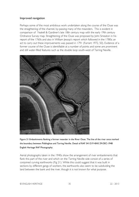
Improved navigationPerhaps some of the most ambitious work undertaken along the course of the Ouse wasthe straightening of the channel, by-passing many of the me<strong>and</strong>ers. This is evident incomparison of Yeakell & Gardiner’s late 18th century map with the early 19th centuryOrdnance Survey map. Straightening of the Ouse was proposed by John Smeaton in hisreport of the 1760s <strong>and</strong> also in William Jessop’s report which followed in the 1780s; anact to carry out these improvements was passed in 1791 (Farrant 1972, 50). Evidence of aformer course of the Ouse is identifiable at a number of points <strong>and</strong> some are prominent<strong>and</strong> still water-filled features such as the double loop south-west of Tarring Neville.Figure 21 Embankments flanking a former me<strong>and</strong>er in the River Ouse. The line of the river once markedthe boundary between Piddinghoe <strong>and</strong> Tarring Neville. Detail of RAF 541/219 4043 29-DEC-1948<strong>English</strong> <strong>Heritage</strong> RAF Photography.<strong>Aerial</strong> photographs taken in the 1940s show the arrangement of river embankments thatflank this part of the river <strong>and</strong> which on the Tarring Neville side consist of a series ofconjoined curving earthworks (Fig 21). While this could suggest that it was built insections by different gangs of workers, the earthworks also seem to be subdividing thel<strong>and</strong> between the bank <strong>and</strong> the river, though it is not known for what purpose.© ENGLISH HERITAGE 35 22 - 2013


