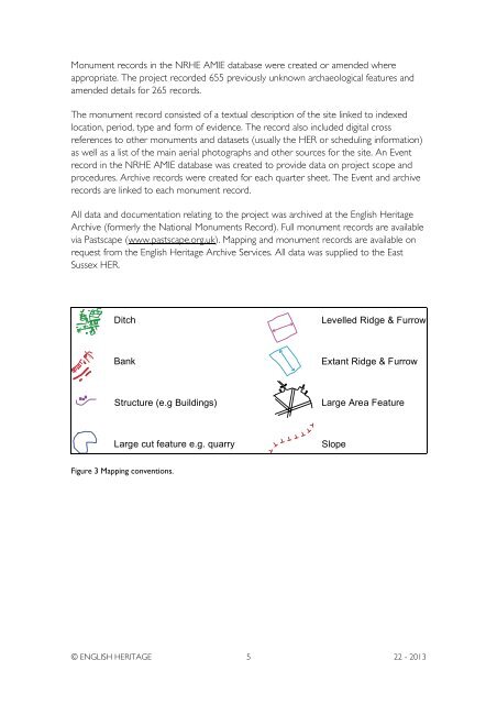
Monument records in the NRHE AMIE database were created or amended whereappropriate. The project recorded 655 previously unknown archaeological features <strong>and</strong>amended details for 265 records.The monument record consisted of a textual description of the site linked to indexedlocation, period, type <strong>and</strong> form of evidence. The record also included digital crossreferences to other monuments <strong>and</strong> datasets (usually the HER or scheduling information)as well as a list of the main aerial photographs <strong>and</strong> other sources for the site. An Eventrecord in the NRHE AMIE database was created to provide data on project scope <strong>and</strong>procedures. Archive records were created for each quarter sheet. The Event <strong>and</strong> archiverecords are linked to each monument record.All data <strong>and</strong> documentation relating to the project was archived at the <strong>English</strong> <strong>Heritage</strong>Archive (formerly the National Monuments Record). Full monument records are availablevia Pastscape (www.pastscape.org.uk). <strong>Mapping</strong> <strong>and</strong> monument records are available onrequest from the <strong>English</strong> <strong>Heritage</strong> Archive Services. All data was supplied to the EastSussex HER.DitchLevelled Ridge & FurrowBankExtant Ridge & FurrowStructure (e.g Buildings)Large Area FeatureLarge cut feature e.g. quarrySlopeFigure 3 <strong>Mapping</strong> conventions.© ENGLISH HERITAGE 5 22 - 2013
NEOLITHIC LONG BARROWSIn the absence of either causewayed enclosures or flint mines from the project area, theearliest monuments encountered are a series of probable or possible Neolithic longbarrows: Money Burgh (AMIE: 406246), Camel’s Humps (406570), Windover Hill(408708), Hunter’s Burgh (408732), Litlington (408791), <strong>and</strong> Exceat (470226). A possiblenew discovery was seen as cropmarks at Rathfinny Farm (1568872). Further long barrowslie just outside the project area, for example: Long Burgh (408646); Alfriston (408685);<strong>and</strong> Firle Beacon (405738).Although the Sussex long barrows featured prominently in explanatory models for thedevelopment of the Neolithic across the South Downs (For example Drewett 1978,2003; Russell 2001, 2002), there has been surprisingly little fieldwork undertaken on them.Sussex’s causewayed enclosures <strong>and</strong> flint mines, many of which were discovered duringthe inter-war years, have seen many episodes of investigation during the 20 th century.However, the only East Sussex long barrow to be excavated was the mound at Alfriston(Drewett 1975), located just outside the project area.The first publication dealing specifically with Sussex long barrows was by Herbert Toms,curator of Brighton Museum <strong>and</strong>, in the 1890s, assistant to Pitt Rivers during some of hiskey excavations on his Cranborne Chase estate. Toms’ 1922 paper on the Sussexmounds featured measured surveys of all 5 long barrows known at the time, 3 of them –Money Burgh, Camel’s Humps, <strong>and</strong> Windover Hill (which he discovered shortly aftersurveying the other 4) – located within the project area. Another, Hunter’s Burgh, wasnoted soon after on aerial photographs. The number has risen gradually since then, ofcourse, but one principal feature of long barrow distribution on the Sussex Downs hasremained relatively constant – most lie in the area of downl<strong>and</strong> between Brighton <strong>and</strong>Eastbourne.Perhaps the key development of recent decades was Drewett’s (1975, 1978, 1986 etc)efforts to distinguish a class of ‘oval barrow’ in the wake of his excavations at Alfriston.These, he argued, were shorter than long barrows generally, their mounds – as the namesuggests – more oval than long (or trapezoidal), <strong>and</strong> – on the basis of his excavations atthe Alfriston example <strong>and</strong>, subsequently, North Marden in West Sussex – later in datethan the larger long barrows. Consequently they could be seen as an intermediate stagebetween the long mounds of the earlier Neolithic <strong>and</strong> the round mounds of the BronzeAge. The idea of a distinct class of oval barrows within Sussex has come in for severecriticism (For example Kinnes 1992; Russell 2001, 2002; Field 2006 etc) – barrows ofsimilar dimensions <strong>and</strong> morphology are quite widespread across southern Britain (Forexample the so-called ‘Cranborne Chase Type’), <strong>and</strong> there is no evidence for them beingmarkedly later, either individually or as a class, than any other kind of long barrow.The recent project focusing primarily on the dating of causewayed enclosures, usingBayesian analysis (Whittle et al 2011), noted of long <strong>and</strong> oval barrows in Sussex that© ENGLISH HERITAGE 6 22 - 2013
- Page 1 and 2: RESEARCH REPORT SERIES no. 22-2013S
- Page 3 and 4: Cover Photograph: Cuckmere Haven, t
- Page 5: ARCHIVE LOCATIONEnglish Heritage,Th
- Page 8 and 9: Figure 1 Revised project area......
- Page 10 and 11: INTRODUCTIONThis report describes t
- Page 12 and 13: Weald cut through the Downs forming
- Page 16 and 17: ‘Although there are up to 20…,
- Page 18 and 19: Figure 5 Toms’ 1920 survey (left)
- Page 20 and 21: Subsequent survey by the Ordnance S
- Page 22 and 23: The evidence from aerial photograph
- Page 24: on aerial photographs as differenti
- Page 27 and 28: Although just outside the project a
- Page 29 and 30: Figure 12 General view of the easte
- Page 31 and 32: large sub-rectangular field that is
- Page 33 and 34: cultivators of these lynchets’ (i
- Page 35 and 36: Forest and Lullington Heath - 37 ly
- Page 37 and 38: SHEEP AND THE DEVIL’S BOOKFrom th
- Page 39 and 40: ‘Celtic’ fields immediately to
- Page 41 and 42: The 1835 reference to the earthwork
- Page 43 and 44: Figure 20 Medieval and post medieva
- Page 45 and 46: Figure 22 An early example of by-pa
- Page 47 and 48: absence of a winch on earlier maps
- Page 49 and 50: Figure 23 Extents of South Camp, ba
- Page 51 and 52: 1988, 234). The grouping of 40 huts
- Page 53 and 54: indicating probable re-use for mili
- Page 55 and 56: 30th January 1943. The wind velocit
- Page 57 and 58: the town appeared to be rendered in
- Page 59 and 60: Movement upriver was hindered by pi
- Page 61 and 62: ground surface. A Diver site was lo
- Page 63 and 64: mouth with lines of pontoons and
- Page 65 and 66:
Figure 33 Trenches aligned approxim
- Page 67 and 68:
The aerial photographs taken by the
- Page 69 and 70:
However, for his painting Coastal D
- Page 71 and 72:
war aerial photographs show a group
- Page 73 and 74:
Figure 40 Camouflage netting over t
- Page 75 and 76:
Description of the current Long Man
- Page 77 and 78:
which would certainly fit with sugg
- Page 79 and 80:
separate from it. The toes of the t
- Page 81 and 82:
other parts of the body, and indeed
- Page 83 and 84:
lip of a large chalk quarry, was, a
- Page 85 and 86:
something for which the likes of Pe
- Page 87:
Hill and the Lavant Caves, both nea
- Page 90 and 91:
to the present day…’ (Butler &
- Page 92 and 93:
least was unsupported by evidence f
- Page 94 and 95:
CONCLUSION AND RECOMMENDATIONS FOR
- Page 96 and 97:
documentary sources or fieldwork. N
- Page 98 and 99:
Barber M, Wickstead, H in press Dam
- Page 100 and 101:
Drewett, P 1978 Neolithic Sussex, i
- Page 102 and 103:
Lowry, B (eds) 2001 20 th Century D
- Page 104:
ENGLISH HERITAGE RESEARCH AND THE H