

Aerial Investigation and Mapping Report - English Heritage
Aerial Investigation and Mapping Report - English Heritage
Aerial Investigation and Mapping Report - English Heritage

You also want an ePaper? Increase the reach of your titles
YUMPU automatically turns print PDFs into web optimized ePapers that Google loves.
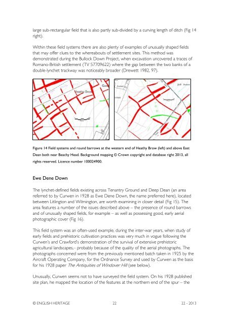
large sub-rectangular field that is also partly sub-divided by a curving length of ditch (Fig 14right).Within these field systems there are also plenty of examples of unusually shaped fieldsthat may offer clues to the whereabouts of settlement sites. This method wasdemonstrated during the Bullock Down Project, when excavation uncovered a traces ofRomano-British settlement (TV 57709622) where the gap between the two banks of adouble-lynchet trackway was noticeably broader (Drewett 1982, 97).Figure 14 Field systems <strong>and</strong> round barrows at the western end of Heathy Brow (left) <strong>and</strong> above EastDean both near Beachy Head. Background mapping © Crown copyright <strong>and</strong> database right 2013, allrights reserved. Licence number 100024900.Ewe Dene DownThe lynchet-defined fields existing across Tenantry Ground <strong>and</strong> Deep Dean (an areareferred to by Curwen in 1928 as Ewe Dene Down, the name preferred here), locatedbetween Litlington <strong>and</strong> Wilmington, are worth examining in closer detail (Fig 15). Thearea features a number of the issues described above – the presence of round barrows<strong>and</strong> of unusually shaped fields, for example – as well as possessing good, early aerialphotographic cover (Fig 16).This field system was an often-used example, during the inter-war years, when study ofearly fields <strong>and</strong> prehistoric cultivation practices was very much in vogue following theCurwen’s <strong>and</strong> Crawford’s demonstration of the survival of extensive prehistoricagricultural l<strong>and</strong>scapes,– probably because of the quality of the aerial photographs. Thephotographs concerned were from the previously mentioned batch taken in 1925 by theAircraft Operating Company, for the Ordnance Survey <strong>and</strong> used by Curwen as the basisfor his 1928 paper The Antiquities of Windover Hill (see below).Unusually, Curwen seems not to have surveyed the field system. On his 1928 publishedsite plan, he mapped the location of the features at the northern end of the spur – the© ENGLISH HERITAGE 22 22 - 2013


