

Aerial Investigation and Mapping Report - English Heritage
Aerial Investigation and Mapping Report - English Heritage
Aerial Investigation and Mapping Report - English Heritage

You also want an ePaper? Increase the reach of your titles
YUMPU automatically turns print PDFs into web optimized ePapers that Google loves.
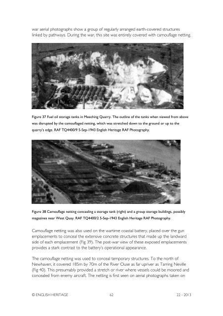
war aerial photographs show a group of regularly arranged earth-covered structureslinked by pathways. During the war, this site was entirely covered with camouflage netting.Figure 37 Fuel oil storage tanks in Meeching Quarry. The outline of the tanks when viewed from abovewas disrupted by the camouflaged netting, which was stretched down to the ground or up to thequarry’s edge. RAF TQ4400/9 5-Sep-1943 <strong>English</strong> <strong>Heritage</strong> RAF Photography.Figure 38 Camouflage netting concealing a storage tank (right) <strong>and</strong> a group storage buildings, possiblymagazines near West Quay. RAF TQ4400/2 5-Sep-1943 <strong>English</strong> <strong>Heritage</strong> RAF Photography.Camouflage netting was also used on the wartime coastal battery, placed over the gunemplacements to conceal the extensive concrete structures that made up the l<strong>and</strong>wardside of each emplacement (Fig 39). The post-war view of these exposed emplacementsprovides a stark contrast to the battery’s operational appearance.The camouflage netting was used to conceal temporary structures. To the north ofNewhaven, it covered 185m by 70m of the River Ouse as far upriver as Tarring Neville(Fig 40). This presumably provided a stretch or river where vessels could be moored <strong>and</strong>concealed from enemy aircraft. The netting is first seen on aerial photographs taken on© ENGLISH HERITAGE 62 22 - 2013


