Bentley Map v8i (SELECTseries 2)
Bentley Map v8i (SELECTseries 2)
Bentley Map v8i (SELECTseries 2)

Create successful ePaper yourself
Turn your PDF publications into a flip-book with our unique Google optimized e-Paper software.
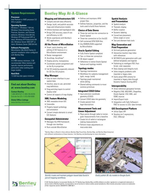
System RequirementsProcessor:Intel Pentium or AMD processor 3.0GHz or greaterOperating Systems:Windows 7, Windows 7 (64 bit),Windows Vista (including HomePremium, Business, and Ultimateeditions), Windows Vista (64-bit),Windows XP Professional (SP2 orlater), Windows XP Professional (64bit), Windows Server 2003 (SP1 orlater), Windows Server 2003 (64 bit)Software Prerequisite:MicroStation V8i (<strong>SELECTseries</strong> 2),optional installation when configuredwith <strong>Bentley</strong> <strong>Map</strong>RAM:512 MB memory minimum, 2 GBrecommended. More memory willtypically improve performance,particularly when working withlarger models.Hard Disk:1.5 GB free disk space minimumFind out about <strong>Bentley</strong>at: www.bentley.comContact <strong>Bentley</strong>1-800-BENTLEY (1-800-236-8539)Outside the US +1 610-458-5000Global Office Listingswww.bentley.com/contact<strong>Bentley</strong> <strong>Map</strong> At-A-Glance<strong>Map</strong>ping and Infrastructure GIS• Compile and edit data efficiently• Design, build, and publish accuratemaps and infrastructure models• Enforce business and topological rules• Brings CAD accuracy, ease-of-useand efficiency to GIS• Works seamlessly with <strong>Bentley</strong>’sAEC applicationsAll the Power of MicroStation• Smart, quick drawing, andediting of GIS features in aMicroStation environment• Raster management• AccuSnap, AccuDraw ®• Display priority, transparency• Coordinate system assignment andon the fly re-projection• Full 3D modeling especially relevantfor 3D City GIS projects<strong>Map</strong> Manager• Easy-to-learn interface to yourspatial data• Intuitive, easy-to-use, persistedmap definitions• Drag-and-drop layers to controldisplay order• Control all aspects of map displayXML Feature Modeling• XML metadata-driven GIS• Extensible• Property-based symbologyand annotation• Convert simple elements to smartGIS featuresGeospatial Administrator• Manages the XFM frameworkthrough one interface• Runs outside MicroStation• Defines and maintains XFMproject files• Defines features, properties, and thetools used to build those featuresChoice of Data Stores• Three-tier and two-tier connection toOracle Spatial• Three-tier connection to Esri ArcGIS• Self-contained XFM DGN files• Any RDBMS/DGN supportedby MicroStationOracle Spatial Editing• Fully Oracle Spatial compliant• Two- or three-tier connection• 3D object support• Adherence to native Oracle Spatialfeature and topology modelsTopology modes• Topology maintenance• Workflows for cadastre management(split, merge, build)• Topology graph maintainedwhile editing• Shared editing commands to movecommon primitivesIntegrated COGO Editor• Input precision coordinategeometry (COGO)• Convert COGO data into geometry• Create parcels fromlegal descriptionsMeasurement Tools andLinear Adjustment• Place points through radial or rectangularmeasurements from a baseline• Create list of radial or rectangularstaking measurements• Perform linear adjustments oninaccurate dataSpatial Analysisand Presentation• Spatial analysis• Thematic display• Buffer creation• Dynamic labeling• Curved text placement,follow angle or curve• Text and element halo tools<strong>Map</strong> Generation andPrint Preparation• Grid and graticule generation• Interactive location map indexwith references• WYSIWYG plot generation with userdefined templates and legends• Publishing to intelligent PDF, Post-Script, color separates• Data cleanup and integrity tools• Solve integrity problems withimported or legacy data• Easily adopt XFM schema forimported or legacy data throughDynamic Feature Scoring (DFS)Interoperability• Direct reference geospatial formats• <strong>Map</strong>Info (TAB, MID/MIF), Shapefiles,Oracle Spatial, CSV, GML, andODBC sources• Import/Export tools• Integration with Safe Software’sFME for access to 225+ data formatsGIS Development Platform• Utilize Open API• Develop via C expressions,XSLT, VBScript*<strong>Bentley</strong> <strong>Map</strong> is offered in three editions (<strong>Bentley</strong> <strong>Map</strong> PowerView, <strong>Bentley</strong> <strong>Map</strong>, and <strong>Bentley</strong> <strong>Map</strong> Enterprise)with different combinations of these features. Visit <strong>Bentley</strong>.com/bentleymap for more information.Quickly create and maintain polygon-based data found inparcel mapping workflows.Easily publish 3D city models to Google Earth.© 2011 <strong>Bentley</strong> Systems, Incorporated. <strong>Bentley</strong>, the “B” <strong>Bentley</strong> logo, <strong>Bentley</strong> <strong>Map</strong>, and MicroStation are either registered or unregistered trademarks orservice marks of <strong>Bentley</strong> Systems, Incorporated or one of its direct or indirect wholly owned subsidiaries. Other brands and product names are trademarksof their respective owners. BAA018710-1/0001 06/11