

Plynlimon (central) - Royal Commission on the Ancient and ...
Plynlimon (central) - Royal Commission on the Ancient and ...
Plynlimon (central) - Royal Commission on the Ancient and ...

Create successful ePaper yourself
Turn your PDF publications into a flip-book with our unique Google optimized e-Paper software.
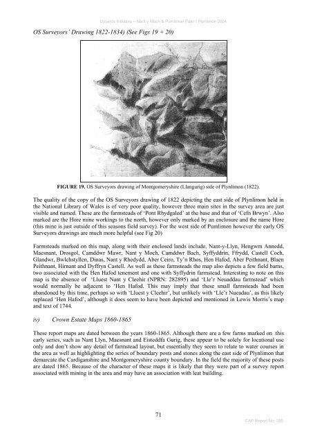
Upl<strong>and</strong>s Initiative – Nant y Moch & Pumlim<strong>on</strong> Fawr / <str<strong>on</strong>g>Plynlim<strong>on</strong></str<strong>on</strong>g> 2004OS Surveyors’ Drawing 1822-1834) (See Figs 19 + 20)FIGURE 19. OS Surveyors drawing of M<strong>on</strong>tgomeryshire (Llangurig) side of <str<strong>on</strong>g>Plynlim<strong>on</strong></str<strong>on</strong>g> (1822).The quality of <strong>the</strong> copy of <strong>the</strong> OS Surveyors drawing of 1822 depicting <strong>the</strong> east side of <str<strong>on</strong>g>Plynlim<strong>on</strong></str<strong>on</strong>g> held in<strong>the</strong> Nati<strong>on</strong>al Library of Wales is of very poor quality, however three main sites in <strong>the</strong> survey area are justvisible <strong>and</strong> named. These are <strong>the</strong> farmsteads of ‗P<strong>on</strong>t Rhydgaled‘ at <strong>the</strong> base <strong>and</strong> that of ‗Cefn Brwyn‘. Alsomarked are <strong>the</strong> Hore mine workings to <strong>the</strong> north, however <strong>on</strong>ly marked by an enclosure <strong>and</strong> <strong>the</strong> name Hore(this mine is just outside of this seas<strong>on</strong>s field survey). For <strong>the</strong> west side of Pumlim<strong>on</strong> however <strong>the</strong> early OSSurveyors drawings are much more helpful (see Fig 20)Farmsteads marked <strong>on</strong> this map, al<strong>on</strong>g with <strong>the</strong>ir enclosed l<strong>and</strong>s include, Nant-y-Llyn, Hengwm Annedd,Maesnant, Drosgol, Camddwr Mawr, Nant y Moch, Camddwr Bach, Syffyddrin, Ffrydd, Castell Coch,Gl<strong>and</strong>wr, Bwlchstyllen, Dinas, Nant y Rhedydd, Aber Ceiro, Ty‘n Rhos, Hen Hafod, Aber Peithnant, BlaenPeithnant, Hirnant <strong>and</strong> Dyffryn Castell. As well as <strong>the</strong>se farmsteads <strong>the</strong> map also depicts a few field barns,two associated with <strong>the</strong> Hen Hafod tenement <strong>and</strong> <strong>on</strong>e with Syffydrin farmstead. Interesting to note <strong>on</strong> thismap is <strong>the</strong> absence of ‗Lluest Nant y Cleehir (NPRN: 282895) <strong>and</strong> ‗Lle‘r Neuaddau farmstead‘ whichwould normally be adjacent to ‗Hen Hafod. This may imply that <strong>the</strong>se small farmsteads had beenab<strong>and</strong><strong>on</strong>ed by this time, perhaps so with ‗Lluest y Cleehir‘, but unlikely with ‗Lle‘r Nueadau‘, as this likelyreplaced ‗Hen Hafod‘, although it does seem to have been depicted <strong>and</strong> menti<strong>on</strong>ed in Lewis Morris‘s map<strong>and</strong> text of 1744.iv) Crown Estate Maps 1860-1865These report maps are dated between <strong>the</strong> years 1860-1865. Although <strong>the</strong>re are a few farms marked <strong>on</strong> thisearly series, such as Nant Llyn, Maesnant <strong>and</strong> Eisteddfa Gurig, <strong>the</strong>se appear to be solely for locati<strong>on</strong>al use<strong>on</strong>ly <strong>and</strong> d<strong>on</strong>‘t show any detail of farmstead layout, but essentially <strong>the</strong>y seem to relate to water courses in<strong>the</strong> area as well as highlighting <strong>the</strong> series of boundary posts <strong>and</strong> st<strong>on</strong>es al<strong>on</strong>g <strong>the</strong> east side of <str<strong>on</strong>g>Plynlim<strong>on</strong></str<strong>on</strong>g> thatdemarcate <strong>the</strong> Cardiganshire <strong>and</strong> M<strong>on</strong>tgomeryshire county boundary. In <strong>the</strong> field <strong>the</strong> majority of <strong>the</strong>se postsare dated 1865. Because of <strong>the</strong> character of <strong>the</strong>se maps it is likely that <strong>the</strong>y were part of a survey reportassociated with mining in <strong>the</strong> area <strong>and</strong> may have an associati<strong>on</strong> with leat building.71CAP Report No: 355


![The Source of the Usk Walk [2012 PDF]](https://img.yumpu.com/49285699/1/190x245/the-source-of-the-usk-walk-2012-pdf.jpg?quality=85)


