LAND 4- Maps 01-10.pdf - Middle Fork American River Project ...
LAND 4- Maps 01-10.pdf - Middle Fork American River Project ...
LAND 4- Maps 01-10.pdf - Middle Fork American River Project ...

Create successful ePaper yourself
Turn your PDF publications into a flip-book with our unique Google optimized e-Paper software.
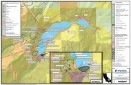
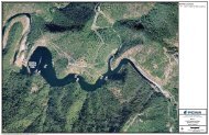
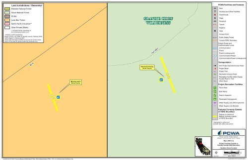
B168BBLand Jurisdictions / Ownership*Eldorado National ForestTahoe National ForestPCWALone Star TimberSierra Pacific Industries**Other Private (Blank)GRANITE CHIEFWILDERNESSPCWA Facilities and FeaturesDamAncillary and Other FacilitiesPowerhouseGagePenstockTunnelPipeline** Includes former properties ofR.H. Emmerson & Son, LLC* PARCEL DATA SOURCES:Placer County, July 2006, El Dorado County, February 2007,USFS Region 5, February 2007.Some data has been modified to account for known errorsand is to be used for general planning purposes only.Trail 15E17GateAccess PointPublic Safety FenceCurrent FERC Boundary<strong>Project</strong> Power andCommunication Lines:CommunicationPowerPower (underground)Communication/PowerCommunication/Power (underground)48.14Diamond CrossingSnow CourseTransportationNon-<strong>Project</strong> General Access Road<strong>Project</strong> Road<strong>Project</strong> TrailRecreation Access RoadMiranda CabinSnow CourseRecreation Facility Water SupplyAccess Road or TrailOther Road<strong>Project</strong> Recreation FacilitiesPicnic AreaBoat RampScenic ViewpointDeveloped CampgroundWater Supply Line (Above ground)Water Supply Line (Buried)Features Currently Outsideof FERC BoundaryFeature or portion offeature currently outsideof FERC Boundary**Highlighted in yellow anddenoted with yellow call-out boxPlacer County Water Agency<strong>Middle</strong> <strong>Fork</strong> <strong>American</strong> <strong>River</strong> <strong>Project</strong>Map <strong>LAND</strong> 4-7j<strong>Project</strong> Facilities Outside orPartially Outside FERC BoundarySouthern Snow Courses0 100 200FeetDate: 4/1/09<strong>Project</strong>ion: Ca. Stateplane, Zone 2Datum: NAD 83Z:\GIS\Entrix\31165<strong>01</strong>\map\Land<strong>Maps</strong>\<strong>LAND</strong>4 <strong>Maps</strong>\PCWA_ProjFacilitiesOutside_FERC_17i11i_<strong>01</strong>_SnowCourses_Southern.mxdCopyright 2009 by Placer County Water Agency