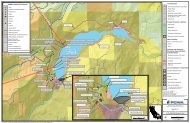
LAND 4- Maps 01-10.pdf - Middle Fork American River Project ...
LAND 4- Maps 01-10.pdf - Middle Fork American River Project ...
LAND 4- Maps 01-10.pdf - Middle Fork American River Project ...

You also want an ePaper? Increase the reach of your titles
YUMPU automatically turns print PDFs into web optimized ePapers that Google loves.
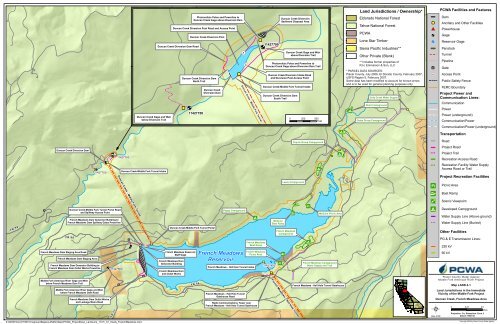
B168BBDuncan Creek Gage and Weirbelow Diversion TrailPhotovoltaic Poles and Powerline toDuncan Creek Gage above Diversion DamDuncan Creek Diversion Pool Road and Access PointDuncan Creek Diversion Dam RoadDuncan Creek Diversion PoolDuncan Creek Diversion DamNorth Trail11427750Duncan CreekDiversion DamDuncan Creek - <strong>Middle</strong> <strong>Fork</strong> Tunnel11427700Duncan Creek DiversionSediment Disposal AreaDuncan Creek-<strong>Middle</strong> <strong>Fork</strong> Tunnel IntakeDuncan Creek Diversion DamSouth TrailDuncan Creek Gage and Weirabove Diversion TrailPhotovoltaic Poles and Powerline toDuncan Creek Gage above Diversion Dam TrailDuncan Creek Diversion Intake Roadand Diversion Pool Access Point0 250 500FeetLand Jurisdictions / Ownership*Eldorado National ForestTahoe National ForestPCWALone Star TimberSierra Pacific Industries**Other Private (Blank)** Includes former properties ofR.H. Emmerson & Son, LLC* PARCEL DATA SOURCES:Placer County, July 2006, El Dorado County, February 2007,USFS Region 5, February 2007.Some data has been modified to account for known errorsand is to be used for general planning purposes only.Dolly Creek Water SupplyAhart CampgroundGates Group CampgroundPCWA Facilities and FeaturesDamAncillary and Other FacilitiesPowerhouseGageReservoir GagePenstockTunnelPipelineGateAccess PointPublic Safety FenceFERC Boundary<strong>Project</strong> Power andCommunication Lines:CommunicationPowerPower (underground)Communication/PowerCommunication/Power (underground)TransportationCoyote Group CampgroundRoadDuncan Creek Diversion Dam11427700<strong>Project</strong> Road<strong>Project</strong> TrailRecreation Access Road11427750Duncan Creek-<strong>Middle</strong> <strong>Fork</strong> Tunnel IntakeRecreation Facility Water SupplyAccess Road or Trail<strong>Project</strong> Recreation FacilitiesLewis CampgroundPicnic AreaBoat RampScenic ViewpointFR 96Duncan Creek-<strong>Middle</strong> <strong>Fork</strong> Tunnel Portal Roadand Spillway Access PointFrench Meadows Dam Generator Building toFrench Meadows Dam Spillway Gates PowerlineFR 96Duncan Creek - <strong>Middle</strong> <strong>Fork</strong> TunnelDuncan Creek-<strong>Middle</strong> <strong>Fork</strong> Tunnel PortalPoppy CampgroundFrench MeadowsBoat RampMcGuireBoat RampFrench MeadowsCampgroundMcGuire Picnic AreaDeveloped CampgroundWater Supply Line (Above ground)Water Supply Line (Buried)Other FacilitiesPG & E Transmission Lines:230 kVFrench Meadows Dam Staging Area RoadFrench Meadows Dam Staging AreaFrench Meadows Dam Generator Building toFrench Meadows Dam Outlet Works Powerline<strong>Middle</strong> <strong>Fork</strong> <strong>American</strong> <strong>River</strong> Gage and Weirbelow French Meadows Dam Trail11427500French Meadows ReservoirStaff GageFrench Meadows DamGenerator BuildingFrench Meadows Damand Outlet WorksFR 96French MeadowsReservoirFrench Meadows - Hell Hole Tunnel IntakeFrench MeadowsPicnic Area11427400French Meadows CampgroundWater Supply and TrailFrench Meadows - Hell Hole Tunnel Gatehouse60 kVPlacer County Water Agency<strong>Middle</strong> <strong>Fork</strong> <strong>American</strong> <strong>River</strong> <strong>Project</strong>Map <strong>LAND</strong> 4-1French Meadows - Hell Hole Tunnel<strong>Middle</strong> <strong>Fork</strong> <strong>American</strong> <strong>River</strong> Gage and Weirbelow French Meadows Dam RoadFrench Meadows Dam Outlet Worksand Leakage Weirs RoadFR 22French Meadows - Hell Hole TunnelGatehouse RoadRadio Communications Tower nearFrench Meadows - Hell Hole Tunnel GatehouseDate: 4/1/09Land Jurisdictions in the ImmediateVicinity of the <strong>Middle</strong> <strong>Fork</strong> <strong>Project</strong>Duncan Creek, French Meadows Area0 0.250.5<strong>Project</strong>ion: Ca. Stateplane, Zone 2Datum: NAD 83MilesZ:\GIS\Entrix\31165<strong>01</strong>\map\Land<strong>Maps</strong>\<strong>LAND</strong>4 <strong>Maps</strong>\PCWA_<strong>Project</strong>Desc_LandJuris_17i11i_<strong>01</strong>_Insets_FrenchMeadows.mxdCopyright 2009 by Placer County Water Agency
B168BBFrench Meadows - Hell Hole TunnelPCWA Facilities and FeaturesDamAncillary and Other FacilitiesPowerhouseGageReservoir GagePenstockTunnelPipelineGateAccess PointPublic Safety FenceFrench Meadows - Hell Hole Tunnel Portal Road14N09French Meadows Powerhouse to French Meadows Powerhouse Penstockand Butterfly Valve House Communication Line / PowerlineFrench Meadows-Hell Hole Tunnel Removable SectionFrench Meadows Powerhouse Penstock and Butterfly Valve House11427200French Meadows Powerhouse and SwitchyardHell HoleReservoirUpper Hell HoleCampgroundFERC Boundary<strong>Project</strong> Power andCommunication Lines:CommunicationPowerPower (underground)Communication/PowerCommunication/Power (underground)Hell Hole VistaHell Hole SubstationTransportationBig Meadows Campground Water Supply and TrailBig Meadows Campground14N43French Meadows Powerhouse and Switchyard to Hell Hole-<strong>Middle</strong> <strong>Fork</strong> Tunnel Gatehouse,Dormitory Facility, Operator Cottages and Hell Hole Powerhouse Communication Line / PowerlineRoad<strong>Project</strong> RoadFrench Meadows Powerhouse Road<strong>Project</strong> TrailFR 2Hell Hole CampgroundDormitory and CottagesWater Supply Tank PowerlineFR 2Hell Hole - <strong>Middle</strong> <strong>Fork</strong> Tunnel GatehouseHell Hole - <strong>Middle</strong> <strong>Fork</strong> Tunnel IntakeHell Hole - <strong>Middle</strong> <strong>Fork</strong> Tunnel Gatehouse RoadRecreation Access RoadRecreation Facility Water SupplyAccess Road or Trail<strong>Project</strong> Recreation FacilitiesDormitory and CottagesWater Supply Tank11428700Hell Hole Dam and Powerhouse Road andSpillway Southern Access PointPicnic AreaHell Hole-<strong>Middle</strong> <strong>Fork</strong> TunnelFR 21Land Jurisdictions / Ownership*Eldorado National ForestTahoe National ForestDormitory FacilityOperator Cottages and ShopHell Hole Dam SpillwayDischarge Channel Road11428800Hell Hole Damand Outlet WorksHell Hole P.H.Hell Hole Reservoir Staff GageHell Hole General Parking AreaDormitory and CottagesWater Supply Tank PowerlineDormitory and CottagesWater Supply TankDormitory Facility RoadHell Hole Boat RampHell Hole Boat Ramp Parking AreaHell Hole Dam Spillway Northern Access PointHell Hole Dam General Parking Area Barrier FenceDormitory FacilityDormitory FacilityBarrier FenceHell Hole Dam and Powerhouse Road andSpillway Southern Access PointHell Hole Dam Leakage WeirBoat RampScenic ViewpointDeveloped CampgroundWater Supply Line (Above ground)Water Supply Line (Buried)Other FacilitiesPG & E Transmission Lines:230 kV60 kVPCWALone Star TimberOperator Cottages and ShopHell Hole Dam Leakage Weir RoadSierra Pacific Industries**Placer County Water Agency<strong>Middle</strong> <strong>Fork</strong> <strong>American</strong> <strong>River</strong> <strong>Project</strong>Other Private (Blank)** Includes former properties ofR.H. Emmerson & Son, LLC* PARCEL DATA SOURCES:Placer County, July 2006, El Dorado County, February 2007,USFS Region 5, February 2007.Some data has been modified to account for known errorsand is to be used for general planning purposes only.Hell Hole Staging AreasHell Hole Dam SpillwayDischarge Channel RoadHell Hole Powerhouse to Rubicon <strong>River</strong> Gage and Weirbelow Hell Hole Dam Communication Line / Powerline11428800Hell Hole PowerhouseRubicon <strong>River</strong> Gage and Weirbelow Hell Hole Dam Road0 500 1,000FeetDate: 4/1/09Map <strong>LAND</strong> 4-2Land Jurisdictions in the ImmediateVicinity of the <strong>Middle</strong> <strong>Fork</strong> <strong>Project</strong>Hell Hole Area0 0.250.5<strong>Project</strong>ion: Ca. Stateplane, Zone 2Datum: NAD 83MilesZ:\GIS\Entrix\31165<strong>01</strong>\map\Land<strong>Maps</strong>\<strong>LAND</strong>4 <strong>Maps</strong>\PCWA_<strong>Project</strong>Desc_LandJuris_17i11i_<strong>01</strong>_Insets_HellHole.mxdCopyright 2009 by Placer County Water Agency
B168BBPCWA Facilities and Features11433080DamNorth <strong>Fork</strong> Long Canyon Diversion Dam and Pool11433085Ancillary and Other FacilitiesNorth <strong>Fork</strong> Long Canyon DiversionNorth RoadNorth <strong>Fork</strong> Long CanyonDiversion PipePowerhouseGageReservoir GagePenstockTunnelNorth <strong>Fork</strong> Long Canyon DiversionSouth RoadPipelineGateAccess PointPublic Safety FenceFERC BoundarySouth <strong>Fork</strong> Long CanyonDiversion Dam<strong>Project</strong> Power andCommunication Lines:North <strong>Fork</strong> Long Canyon DiversionDrop InletNorth <strong>Fork</strong> Long Canyon DiversionDrop Inlet Road0 500 1,000FeetNorth <strong>Fork</strong> Long CanyonDiversion Dam1143308<strong>01</strong>14330851143306<strong>01</strong>1433065<strong>Middle</strong> MeadowsGroup Campground<strong>Middle</strong> Meadows Group CampgroundWater Supply and TrailCommunicationPowerPower (underground)Communication/PowerCommunication/Power (underground)TransportationFR 22RoadFR 2<strong>Project</strong> Road<strong>Project</strong> TrailRecreation Access RoadRecreation Facility Water SupplyAccess Road or Trail<strong>Project</strong> Recreation FacilitiesFR 2<strong>Middle</strong> Meadows Group CampgroundPicnic AreaNorth <strong>Fork</strong> Long Canyon Crossing Removable SectionNorth Road and Parking AreaNorth <strong>Fork</strong> Long Canyon CrossingRemovable Section Barrier FenceBoat RampScenic ViewpointSouth <strong>Fork</strong> Long Canyon Diversion andDrop Inlet RoadDeveloped CampgroundFR 25Land Jurisdictions / Ownership*Eldorado National ForestTahoe National ForestPCWALone Star TimberHell Hole - <strong>Middle</strong> <strong>Fork</strong> TunnelFR 23FR 2North <strong>Fork</strong> Long Canyon Crossing Removable SectionNorth <strong>Fork</strong> Long Canyon CrossingRemovable Section South RoadNorth <strong>Fork</strong> Long Canyon CrossingSediment Disposal AreaSouth <strong>Fork</strong> Long Canyon DiversionDrop Inlet1143306<strong>01</strong>1433065South <strong>Fork</strong> Long Canyon Diversion Damand PoolSouth <strong>Fork</strong> Long Canyon Diversion Pipe0 250 500FeetWater Supply Line (Above ground)Water Supply Line (Buried)Other FacilitiesPG & E Transmission Lines:230 kV60 kVSierra Pacific Industries**Placer County Water Agency<strong>Middle</strong> <strong>Fork</strong> <strong>American</strong> <strong>River</strong> <strong>Project</strong>Other Private (Blank)** Includes former properties ofR.H. Emmerson & Son, LLC* PARCEL DATA SOURCES:Placer County, July 2006, El Dorado County, February 2007,USFS Region 5, February 2007.Some data has been modified to account for known errorsand is to be used for general planning purposes only.Date: 4/1/09Map <strong>LAND</strong> 4-3Land Jurisdictions in the ImmediateVicinity of the <strong>Middle</strong> <strong>Fork</strong> <strong>Project</strong>Long Canyon Area0 0.250.5<strong>Project</strong>ion: Ca. Stateplane, Zone 2Datum: NAD 83MilesZ:\GIS\Entrix\31165<strong>01</strong>\map\Land<strong>Maps</strong>\<strong>LAND</strong>4 <strong>Maps</strong>\PCWA_<strong>Project</strong>Desc_LandJuris_17i11i_<strong>01</strong>_Insets_LongCanyon.mxdCopyright 2009 by Placer County Water Agency
B168BB<strong>Middle</strong> <strong>Fork</strong> Interbay Dam14N3<strong>01</strong>1427770<strong>Middle</strong> <strong>Fork</strong>-Ralston Tunnel<strong>Middle</strong> <strong>Fork</strong>-Ralston TunnelIntake and Gatehouse<strong>Middle</strong> <strong>Fork</strong> Powerhouse to <strong>Middle</strong> <strong>Fork</strong> <strong>American</strong> <strong>River</strong>Gage above <strong>Middle</strong> <strong>Fork</strong> PowerhouseCommunication Line / PowerlineBrushy Canyon Adit<strong>Middle</strong> <strong>Fork</strong> Powerhouse andUpper and Lower Switchyards<strong>Middle</strong> <strong>Fork</strong> Interbay Damand Powerhouse Roadand Interbay Access Points<strong>Middle</strong> <strong>Fork</strong> Powerhouse to <strong>Middle</strong> <strong>Fork</strong>-Ralston Tunnel Intakeand Gatehouse Communication Line / Powerline<strong>Middle</strong> <strong>Fork</strong> Powerhouse Upper Switchyard Road<strong>Middle</strong> <strong>Fork</strong> <strong>American</strong> <strong>River</strong> Gageabove <strong>Middle</strong> <strong>Fork</strong> Powerhouse TrailBrushy Canyon Adit Road1142860<strong>01</strong>1427760<strong>Middle</strong> <strong>Fork</strong> Powerhouse Penstockand Butterfly Valve House Road<strong>Middle</strong> <strong>Fork</strong> Powerhouse to<strong>Middle</strong> <strong>Fork</strong> PowerhouseButterfly Valve HouseCommunication Line / Powerline0 500 1,000Feet<strong>Middle</strong> <strong>Fork</strong>-Ralston TunnelFR 96<strong>Middle</strong> <strong>Fork</strong>-Ralston TunnelIntake and Gatehouse<strong>Middle</strong> <strong>Fork</strong> InterbaySediment Disposal Area11427770<strong>Middle</strong> <strong>Fork</strong>Interbay11428600<strong>Middle</strong> <strong>Fork</strong> Powerhouse to <strong>Middle</strong> <strong>Fork</strong> PowerhouseButterfly Valve House Communication Line / Powerline<strong>Middle</strong> <strong>Fork</strong> PowerhouseButterfly Valve House Road<strong>Middle</strong> <strong>Fork</strong> Interbay Dam and Powerhouse Roadand Interbay Access Points14N5 5Passive Microwave Reflector Stationabove <strong>Middle</strong> <strong>Fork</strong> Interbay<strong>Middle</strong> <strong>Fork</strong> Interbay Dam11427760<strong>Middle</strong> <strong>Fork</strong> Powerhouseand Upper and Lower Switchyards14N5614N31<strong>Middle</strong> <strong>Fork</strong> Powerhouse Penstock and Butterfly Valve House Road<strong>Middle</strong> <strong>Fork</strong> Powerhouse Penstock and Butterfly Valve HouseHell Hole -<strong>Middle</strong> <strong>Fork</strong> Tunnel Removable Section<strong>Middle</strong> <strong>Fork</strong> Powerhouse Butterfly Valve House to Radio Repeater nearHell Hole-<strong>Middle</strong> <strong>Fork</strong> Tunnel Surge Tank (underground) Communication Line / PowerlineRadio Communications Tower and Repeater nearHell Hole-<strong>Middle</strong> <strong>Fork</strong> Tunnel Surge Shaft and TankHell Hole - <strong>Middle</strong> <strong>Fork</strong> TunnelSurge Shaft and TankPassive Microwave Reflector Stationabove <strong>Middle</strong> <strong>Fork</strong> Interbay TrailHell Hole-<strong>Middle</strong> <strong>Fork</strong> TunnelLand Jurisdictions / Ownership*Eldorado National ForestTahoe National ForestPCWALone Star TimberSierra Pacific Industries**Other Private (Blank)** Includes former properties ofR.H. Emmerson & Son, LLC* PARCEL DATA SOURCES:Placer County, July 2006, El Dorado County, February 2007,USFS Region 5, February 2007.Some data has been modified to account for known errorsand is to be used for general planning purposes only.PCWA Facilities and FeaturesDamAncillary and Other FacilitiesPowerhouseGageReservoir GagePenstockTunnelPipelineGateAccess PointPublic Safety FenceFERC Boundary<strong>Project</strong> Power andCommunication Lines:CommunicationPowerPower (underground)Communication/PowerCommunication/Power (underground)TransportationRoad<strong>Project</strong> Road<strong>Project</strong> TrailRecreation Access RoadRecreation Facility Water SupplyAccess Road or Trail<strong>Project</strong> Recreation FacilitiesHell Hole - <strong>Middle</strong> <strong>Fork</strong> TunnelPicnic AreaBoat RampScenic ViewpointDeveloped CampgroundWater Supply Line (Above ground)Water Supply Line (Buried)Other FacilitiesPG & E Transmission Lines:230 kV60 kVPlacer County Water Agency<strong>Middle</strong> <strong>Fork</strong> <strong>American</strong> <strong>River</strong> <strong>Project</strong>Map <strong>LAND</strong> 4-4Land Jurisdictions in the ImmediateVicinity of the <strong>Middle</strong> <strong>Fork</strong> <strong>Project</strong>FR 25<strong>Middle</strong> <strong>Fork</strong> Interbay AreaDate: 4/1/090 0.250.5<strong>Project</strong>ion: Ca. Stateplane, Zone 2Datum: NAD 83MilesZ:\GIS\Entrix\31165<strong>01</strong>\map\Land<strong>Maps</strong>\<strong>LAND</strong>4 <strong>Maps</strong>\PCWA_<strong>Project</strong>Desc_LandJuris_17i11i_<strong>01</strong>_Insets_Interbay.mxdCopyright 2009 by Placer County Water Agency
B168BBLand Jurisdictions / Ownership*PCWA Facilities and FeaturesOxbow Powerhouse and SwitchyardRalston-Oxbow Tunnel Intake toRalston Powerhouse Communication LineEldorado National ForestTahoe National ForestPCWALone Star TimberDamAncillary and Other FacilitiesPowerhouseGageReservoir GageIndian Bar Rafting Accessand General ParkingIndian Bar Sediment Disposal AreaOxbow Powerhouse toRalston Afterbay Dam Generator BuildingCommunication Line / PowerlineOxbow Powerhouse Road11433212Ralston-Oxbow TunnelRalston-Oxbow Tunnel IntakeRalston Afterbay Dam Generator Building toRalston-Oxbow Tunnel Intake Communication/PowerlineRalston-Oxbow Tunnel Intake RoadRalston Afterbay Road and Boat RampMosquito Rid g e RoadFR 96Sierra Pacific Industries**Other Private (Blank)** Includes former properties ofR.H. Emmerson & Son, LLC* PARCEL DATA SOURCES:Placer County, July 2006, El Dorado County, February 2007,USFS Region 5, February 2007.Some data has been modified to account for known errorsand is to be used for general planning purposes only.PenstockTunnelPipelineGateAccess PointPublic Safety FenceFERC Boundary<strong>Project</strong> Power andCommunication Lines:CommunicationPowerPower (underground)Ralston Afterbay Dam Generator BuildingRalstonAfterbayCommunication/PowerCommunication/Power (underground)TransportationRalston Afterbay DamRalston Afterbay Dam Roadand Afterbay Access PointRoad<strong>Project</strong> Road0 250 500Feet<strong>Project</strong> TrailRecreation Access RoadBrushy Canyon AditRecreation Facility Water SupplyAccess Road or Trail<strong>Middle</strong> <strong>Fork</strong> <strong>American</strong> <strong>River</strong> Gagebelow Oxbow Powerhouse Trail11433300Oxbow Powerhouse and SwitchyardRalston Afterbay Dam11433212RalstonAfterbayRalston-Oxbow TunnelRalston AfterbaySediment Removal Access PointRalston-Oxbow Tunnel IntakeRalston Powerhouse Butterfly Valve House RoadRalston Powerhouseand SwitchyardFR 96Ralston-Oxbow Tunnel Intake toRalston Powerhouse Communication LineRalston Picnic Areaand Cartop Boat Ramp11427765Ralston Ridge Sediment Disposal Area<strong>Middle</strong> <strong>Fork</strong> - Ralston TunnelSurge Shaft, Tank and Storage Building<strong>Middle</strong> <strong>Fork</strong>-Ralston TunnelRemovable SectionRalston Powerhouse Penstockand Butterfly Valve HouseRalston Powerhouse to Ralston PowerhouseButterfly Valve House Communication Line / PowerlineFR 23<strong>Middle</strong> <strong>Fork</strong> - Ralston TunnelBrushy Canyon Adit Road14N3 0<strong>Project</strong> Recreation FacilitiesPicnic AreaBoat RampScenic ViewpointDeveloped CampgroundWater Supply Line (Above ground)Water Supply Line (Buried)Other FacilitiesPG & E Transmission Lines:230 kV60 kVPassive Microwave Reflector Stationabove Ralston Afterbay TrailPassive Microwave Reflector Stationabove Ralston AfterbayPlacer County Water Agency<strong>Middle</strong> <strong>Fork</strong> <strong>American</strong> <strong>River</strong> <strong>Project</strong>Map <strong>LAND</strong> 4-5Land Jurisdictions in the ImmediateVicinity of the <strong>Middle</strong> <strong>Fork</strong> <strong>Project</strong>Ralston, Oxbow AreaDate: 4/1/090 0.250.5<strong>Project</strong>ion: Ca. Stateplane, Zone 2Datum: NAD 83MilesZ:\GIS\Entrix\31165<strong>01</strong>\map\Land<strong>Maps</strong>\<strong>LAND</strong>4 <strong>Maps</strong>\PCWA_<strong>Project</strong>Desc_LandJuris_17i11i_<strong>01</strong>_Insets_Ralston.mxdCopyright 2009 by Placer County Water Agency
B168BBLand Jurisdictions / Ownership*Eldorado National ForestTahoe National ForestPCWALone Star TimberFR 96Duncan Creek-<strong>Middle</strong> <strong>Fork</strong>Tunnel PortalPCWA Facilities and FeaturesDamAncillary and Other FacilitiesPowerhouseGagePenstockSierra Pacific Industries**TunnelOther Private (Blank)Pipeline** Includes former properties ofR.H. Emmerson & Son, LLC* PARCEL DATA SOURCES:Placer County, July 2006, El Dorado County, February 2007,USFS Region 5, February 2007.Some data has been modified to account for known errorsand is to be used for general planning purposes only.French Meadows Damand Outlet WorksGateAccess PointPublic Safety FenceCurrent FERC Boundary<strong>Project</strong> Power andCommunication Lines:CommunicationPowerPower (underground)Communication/PowerCommunication/Power (underground)TransportationNon-<strong>Project</strong> General Access Road<strong>Project</strong> Road11427500French MeadowsReservoir<strong>Project</strong> TrailRecreation Access RoadRecreation Facility Water SupplyAccess Road or TrailOther Road<strong>Project</strong> Recreation FacilitiesPicnic AreaBoat Ramp<strong>Middle</strong> <strong>Fork</strong> <strong>American</strong> <strong>River</strong> Gage and Weirand Photovoltaic Pole and Powerlinebelow French Meadows Dam and TrailScenic ViewpointDeveloped CampgroundWater Supply Line (Above ground)Water Supply Line (Buried)Features Currently Outsideof FERC BoundaryFR 96Feature or portion offeature currently outsideof FERC Boundary*FR 22*Highlighted in yellow anddenoted with yellow call-out boxPlacer County Water Agency<strong>Middle</strong> <strong>Fork</strong> <strong>American</strong> <strong>River</strong> <strong>Project</strong>Map <strong>LAND</strong> 4-7b<strong>Project</strong> Facilities Outside orPartially Outside FERC BoundaryWest French Meadows Area0 250 500FeetDate: 4/2/09<strong>Project</strong>ion: Ca. Stateplane, Zone 2Datum: NAD 83Z:\GIS\Entrix\31165<strong>01</strong>\map\Land<strong>Maps</strong>\<strong>LAND</strong>4 <strong>Maps</strong>\PCWA_ProjFacilitiesOutside_FERC_17i11i_<strong>01</strong>_FrenchMeadows.mxdCopyright 2009 by Placer County Water Agency
B168BBLand Jurisdictions / Ownership*PCWA Facilities and FeaturesEldorado National ForestDamTahoe National ForestPCWALone Star TimberSierra Pacific Industries**Other Private (Blank)** Includes former properties ofR.H. Emmerson & Son, LLC* PARCEL DATA SOURCES:Placer County, July 2006, El Dorado County, February 2007,USFS Region 5, February 2007.Some data has been modified to account for known errorsand is to be used for general planning purposes only.FR 2Hell Hole - <strong>Middle</strong> <strong>Fork</strong> TunnelAncillary and Other FacilitiesPowerhouseGagePenstockTunnelPipelineGateAccess PointPublic Safety FenceCurrent FERC Boundary<strong>Project</strong> Power andCommunication Lines:CommunicationPowerPower (underground)North <strong>Fork</strong> Long Canyon CrossingRemovable Section North Roadand Parking AreaNorth <strong>Fork</strong> Long Canyon CrossingRemovable SectionCommunication/PowerCommunication/Power (underground)TransportationNon-<strong>Project</strong> General Access Road<strong>Project</strong> Road<strong>Project</strong> TrailRecreation Access RoadRecreation Facility Water SupplyAccess Road or TrailNorth <strong>Fork</strong> Long Canyon CrossingRemovable Section South RoadOther Road<strong>Project</strong> Recreation FacilitiesPicnic AreaBoat RampScenic ViewpointDeveloped CampgroundWater Supply Line (Above ground)Water Supply Line (Buried)Features Currently Outsideof FERC BoundaryFeature or portion offeature currently outsideof FERC Boundary**Highlighted in yellow anddenoted with yellow call-out boxFR 2314N16North <strong>Fork</strong> Long Canyon CrossingSediment Disposal AreaPlacer County Water Agency<strong>Middle</strong> <strong>Fork</strong> <strong>American</strong> <strong>River</strong> <strong>Project</strong>Map <strong>LAND</strong> 4-7e<strong>Project</strong> Facilities Outside orPartially Outside FERC BoundaryNorth <strong>Fork</strong> Long Canyon Crossing Area0 250 500FeetDate: 4/2/09<strong>Project</strong>ion: Ca. Stateplane, Zone 2Datum: NAD 83Z:\GIS\Entrix\31165<strong>01</strong>\map\Land<strong>Maps</strong>\<strong>LAND</strong>4 <strong>Maps</strong>\PCWA_ProjFacilitiesOutside_FERC_17i11i_<strong>01</strong>_LongCanyon.mxdCopyright 2009 by Placer County Water Agency
B168BBFR 96PCWA Facilities and FeaturesDam96.17<strong>Middle</strong> <strong>Fork</strong> Interbay Sediment Disposal AreaAncillary and Other FacilitiesPowerhouseGagePenstockTunnelPipelineGateAccess PointPublic Safety FenceCurrent FERC Boundary<strong>Project</strong> Power andCommunication Lines:CommunicationPowerPower (underground)Communication/PowerCommunication/Power (underground)TransportationPassive Microwave Reflector Stationabove <strong>Middle</strong> <strong>Fork</strong> Interbay and TrailNon-<strong>Project</strong> General Access Road<strong>Project</strong> Road<strong>Project</strong> Trail<strong>Middle</strong> <strong>Fork</strong> Interbay Dam and Powerhouse Roadand Interbay Access PointRecreation Access RoadRecreation Facility Water SupplyAccess Road or TrailOther Road<strong>Project</strong> Recreation FacilitiesPicnic AreaBoat Ramp1142777<strong>01</strong>1427760Scenic Viewpoint<strong>Middle</strong> <strong>Fork</strong> Interbay Dam<strong>Middle</strong> <strong>Fork</strong> Powerhouse Penstockand Butterfly Valve House RoadDeveloped CampgroundWater Supply Line (Above ground)<strong>Middle</strong> <strong>Fork</strong> Powerhouseand Upper and Lower SwitchyardsWater Supply Line (Buried)Features Currently Outsideof FERC BoundaryLand Jurisdictions / Ownership*Feature or portion offeature currently outsideof FERC Boundary*Eldorado National Forest*Highlighted in yellow anddenoted with yellow call-out boxTahoe National ForestPCWALone Star TimberSierra Pacific Industries**<strong>Middle</strong> <strong>Fork</strong> Powerhouse Butterfly Valve House RoadHell Hole - <strong>Middle</strong> <strong>Fork</strong> TunnelPlacer County Water Agency<strong>Middle</strong> <strong>Fork</strong> <strong>American</strong> <strong>River</strong> <strong>Project</strong>Other Private (Blank)** Includes former properties ofR.H. Emmerson & Son, LLC14N5514N56Map <strong>LAND</strong> 4-7f<strong>Project</strong> Facilities Outside orPartially Outside FERC Boundary* PARCEL DATA SOURCES:Placer County, July 2006, El Dorado County, February 2007,USFS Region 5, February 2007.Some data has been modified to account for known errorsand is to be used for general planning purposes only.14N31Date: 4/1/09<strong>Middle</strong> <strong>Fork</strong> Interbay Area0 1,0002,000Feet<strong>Project</strong>ion: Ca. Stateplane, Zone 2Datum: NAD 83Z:\GIS\Entrix\31165<strong>01</strong>\map\Land<strong>Maps</strong>\<strong>LAND</strong>4 <strong>Maps</strong>\PCWA_ProjFacilitiesOutside_FERC_17i11i_<strong>01</strong>_Interbay.mxdCopyright 2009 by Placer County Water Agency
B168BBLand Jurisdictions / Ownership*Eldorado National ForestTahoe National ForestPCWALone Star TimberSierra Pacific Industries**Other Private (Blank)** Includes former properties ofR.H. Emmerson & Son, LLC* PARCEL DATA SOURCES:Placer County, July 2006, El Dorado County, February 2007,USFS Region 5, February 2007.Some data has been modified to account for known errorsand is to be used for general planning purposes only.Brushy Canyon Adit RoadBrushy Canyon Adit<strong>Middle</strong> <strong>Fork</strong> - Ralston TunnelPCWA Facilities and FeaturesDamAncillary and Other FacilitiesPowerhouseGagePenstockTunnelPipelineGateAccess PointPublic Safety FenceCurrent FERC Boundary<strong>Project</strong> Power andCommunication Lines:CommunicationPowerPower (underground)Communication/PowerCommunication/Power (underground)TransportationNon-<strong>Project</strong> General Access Road<strong>Project</strong> Road<strong>Project</strong> TrailRecreation Access RoadRecreation Facility Water SupplyAccess Road or TrailOther Road<strong>Project</strong> Recreation FacilitiesPicnic AreaBoat RampScenic ViewpointDeveloped CampgroundWater Supply Line (Above ground)Water Supply Line (Buried)Features Currently Outsideof FERC BoundaryFeature or portion offeature currently outsideof FERC Boundary**Highlighted in yellow anddenoted with yellow call-out boxPlacer County Water Agency<strong>Middle</strong> <strong>Fork</strong> <strong>American</strong> <strong>River</strong> <strong>Project</strong>FR 2314N30Map <strong>LAND</strong> 4-7g<strong>Project</strong> Facilities Outside orPartially Outside FERC BoundaryBrushy Canyon Area0 250 500FeetDate: 4/1/09<strong>Project</strong>ion: Ca. Stateplane, Zone 2Datum: NAD 83Z:\GIS\Entrix\31165<strong>01</strong>\map\Land<strong>Maps</strong>\<strong>LAND</strong>4 <strong>Maps</strong>\PCWA_ProjFacilitiesOutside_FERC_17i11i_<strong>01</strong>_BrushyCanyon.mxdCopyright 2009 by Placer County Water Agency
B168BBPCWA Facilities and FeaturesDamFR 96Ancillary and Other FacilitiesPowerhouseGageFR 96PenstockTunnelPipelineGateAccess Point96.6Public Safety FenceCurrent FERC Boundary<strong>Project</strong> Power andCommunication Lines:11433300Oxbow Powerhouseand SwitchyardRalston – Oxbow Tunnel Intake toRalston Powerhouse Communication LineRalston Ridge Sediment Disposal AreaFR 23CommunicationPowerPower (underground)Communication/Power<strong>Middle</strong> <strong>Fork</strong> <strong>American</strong> <strong>River</strong> Gageand Photovoltaic Polebelow Oxbow Powerhouse and TrailRalstonAfterbay23.2FR 23<strong>Middle</strong> <strong>Fork</strong> - Ralston TunnelCommunication/Power (underground)TransportationNon-<strong>Project</strong> General Access Road<strong>Project</strong> Road<strong>Project</strong> TrailRecreation Access RoadRalston Afterbay Dam11427765Recreation Facility Water SupplyAccess Road or TrailOther Road<strong>Project</strong> Recreation FacilitiesRalston Powerhouseand SwitchyardPicnic AreaBoat RampScenic ViewpointDeveloped CampgroundWater Supply Line (Above ground)Land Jurisdictions / Ownership*Eldorado National ForestTahoe National ForestPCWALone Star TimberSierra Pacific Industries**Passive Microwave Reflector Stationabove Ralston Afterbay and TrailWater Supply Line (Buried)Features Currently Outsideof FERC BoundaryFeature or portion offeature currently outsideof FERC Boundary**Highlighted in yellow anddenoted with yellow call-out boxPlacer County Water Agency<strong>Middle</strong> <strong>Fork</strong> <strong>American</strong> <strong>River</strong> <strong>Project</strong>Other Private (Blank)Map <strong>LAND</strong> 4-7h** Includes former properties ofR.H. Emmerson & Son, LLC<strong>Project</strong> Facilities Outside orPartially Outside FERC Boundary* PARCEL DATA SOURCES:Placer County, July 2006, El Dorado County, February 2007,USFS Region 5, February 2007.Some data has been modified to account for known errorsand is to be used for general planning purposes only.Date: 4/2/09Ralston, Oxbow Area0 500 1,000Feet<strong>Project</strong>ion: Ca. Stateplane, Zone 2Datum: NAD 83Z:\GIS\Entrix\31165<strong>01</strong>\map\Land<strong>Maps</strong>\<strong>LAND</strong>4 <strong>Maps</strong>\PCWA_ProjFacilitiesOutside_FERC_17i11i_<strong>01</strong>_Ralston.mxdCopyright 2009 by Placer County Water Agency
B168BBLand Jurisdictions / Ownership*Eldorado National ForestTahoe National ForestPCWALone Star TimberSierra Pacific Industries**Other Private (Blank)** Includes former properties ofR.H. Emmerson & Son, LLC* PARCEL DATA SOURCES:Placer County, July 2006, El Dorado County, February 2007,USFS Region 5, February 2007.Some data has been modified to account for known errorsand is to be used for general planning purposes only.PCWA Facilities and FeaturesDamAncillary and Other FacilitiesPowerhouseGagePenstockTunnelPipelineGateAccess PointPublic Safety FenceCurrent FERC Boundary<strong>Project</strong> Power andCommunication Lines:CommunicationPowerPower (underground)Communication/PowerCommunication/Power (underground)TransportationWabena MeadowsSnow CourseNon-<strong>Project</strong> General Access Road<strong>Project</strong> Road<strong>Project</strong> TrailRecreation Access RoadRecreation Facility Water SupplyAccess Road or TrailOther Road<strong>Project</strong> Recreation FacilitiesPicnic AreaTalbot CampSnow CourseBoat RampScenic ViewpointBaker Ranch - Soda Springs Road16E10Developed CampgroundWater Supply Line (Above ground)Water Supply Line (Buried)Features Currently Outsideof FERC BoundaryFeature or portion offeature currently outsideof FERC Boundary**Highlighted in yellow anddenoted with yellow call-out boxPlacer County Water Agency<strong>Middle</strong> <strong>Fork</strong> <strong>American</strong> <strong>River</strong> <strong>Project</strong>Map <strong>LAND</strong> 4-7i<strong>Project</strong> Facilities Outside orPartially Outside FERC BoundaryNorthern Snow Courses0 100 200FeetDate: 4/1/09<strong>Project</strong>ion: Ca. Stateplane, Zone 2Datum: NAD 83Z:\GIS\Entrix\31165<strong>01</strong>\map\Land<strong>Maps</strong>\<strong>LAND</strong>4 <strong>Maps</strong>\PCWA_ProjFacilitiesOutside_FERC_17i11i_<strong>01</strong>_SnowCourses_Northern.mxdCopyright 2009 by Placer County Water Agency
B168BBLand Jurisdictions / Ownership*Eldorado National ForestTahoe National ForestPCWALone Star TimberSierra Pacific Industries**Other Private (Blank)GRANITE CHIEFWILDERNESSPCWA Facilities and FeaturesDamAncillary and Other FacilitiesPowerhouseGagePenstockTunnelPipeline** Includes former properties ofR.H. Emmerson & Son, LLC* PARCEL DATA SOURCES:Placer County, July 2006, El Dorado County, February 2007,USFS Region 5, February 2007.Some data has been modified to account for known errorsand is to be used for general planning purposes only.Trail 15E17GateAccess PointPublic Safety FenceCurrent FERC Boundary<strong>Project</strong> Power andCommunication Lines:CommunicationPowerPower (underground)Communication/PowerCommunication/Power (underground)48.14Diamond CrossingSnow CourseTransportationNon-<strong>Project</strong> General Access Road<strong>Project</strong> Road<strong>Project</strong> TrailRecreation Access RoadMiranda CabinSnow CourseRecreation Facility Water SupplyAccess Road or TrailOther Road<strong>Project</strong> Recreation FacilitiesPicnic AreaBoat RampScenic ViewpointDeveloped CampgroundWater Supply Line (Above ground)Water Supply Line (Buried)Features Currently Outsideof FERC BoundaryFeature or portion offeature currently outsideof FERC Boundary**Highlighted in yellow anddenoted with yellow call-out boxPlacer County Water Agency<strong>Middle</strong> <strong>Fork</strong> <strong>American</strong> <strong>River</strong> <strong>Project</strong>Map <strong>LAND</strong> 4-7j<strong>Project</strong> Facilities Outside orPartially Outside FERC BoundarySouthern Snow Courses0 100 200FeetDate: 4/1/09<strong>Project</strong>ion: Ca. Stateplane, Zone 2Datum: NAD 83Z:\GIS\Entrix\31165<strong>01</strong>\map\Land<strong>Maps</strong>\<strong>LAND</strong>4 <strong>Maps</strong>\PCWA_ProjFacilitiesOutside_FERC_17i11i_<strong>01</strong>_SnowCourses_Southern.mxdCopyright 2009 by Placer County Water Agency
B168BBLand Jurisdictions / Ownership*Eldorado National ForestTahoe National ForestPCWALone Star TimberSierra Pacific Industries**Other Private (Blank)Dolly Creek Water SupplyPCWA Facilities and FeaturesDamAncillary and Other FacilitiesPowerhouseGagePenstockTunnelPipeline** Includes former properties ofR.H. Emmerson & Son, LLC* PARCEL DATA SOURCES:Placer County, July 2006, El Dorado County, February 2007,USFS Region 5, February 2007.Some data has been modified to account for known errorsand is to be used for general planning purposes only.FR 96Gates Group CampgroundAhart CampgroundGateAccess PointPublic Safety FenceCurrent FERC Boundary<strong>Project</strong> Power andCommunication Lines:CommunicationPowerPower (underground)Communication/PowerCommunication/Power (underground)TransportationNon-<strong>Project</strong> General Access Road<strong>Project</strong> Road<strong>Project</strong> TrailFR 68Recreation Access RoadRecreation Facility Water SupplyAccess Road or TrailOther Road<strong>Project</strong> Recreation FacilitiesPicnic AreaBoat RampScenic ViewpointDeveloped CampgroundRecreation Facility FootprintWater Supply Line (Above ground)Coyote Group CampgroundWater Supply Line (Buried)Features Currently Outsideof FERC BoundaryFeature or portion offeature currently outsideof FERC Boundary**Highlighted in yellow anddenoted with yellow call-out boxPlacer County Water Agency<strong>Middle</strong> <strong>Fork</strong> <strong>American</strong> <strong>River</strong> <strong>Project</strong>Map <strong>LAND</strong> 4-8a<strong>Project</strong> Recreation Facilities Outsideor Partially Outside FERC BoundaryEast French Meadows Area0 250 500FeetDate: 3/3/09<strong>Project</strong>ion: Ca. Stateplane, Zone 2Datum: NAD 83Z:\GIS\Entrix\31165<strong>01</strong>\map\Land<strong>Maps</strong>\<strong>LAND</strong>4 <strong>Maps</strong>\PCWA_RecreationFacilitiesOutside_FERC_17i11i_<strong>01</strong>_FrenchMeadows.mxdCopyright 2009 by Placer County Water Agency
B168BBLand Jurisdictions / Ownership*Eldorado National ForestTahoe National ForestPCWALone Star TimberSierra Pacific Industries**Other Private (Blank)** Includes former properties ofR.H. Emmerson & Son, LLC* PARCEL DATA SOURCES:Placer County, July 2006, El Dorado County, February 2007,USFS Region 5, February 2007.Some data has been modified to account for known errorsand is to be used for general planning purposes only.Lewis CampgroundPCWA Facilities and FeaturesDamAncillary and Other FacilitiesPowerhouseGagePenstockTunnelPipelineGateAccess PointPublic Safety FenceCurrent FERC Boundary<strong>Project</strong> Power andCommunication Lines:CommunicationPowerPower (underground)Communication/PowerCommunication/Power (underground)TransportationNon-<strong>Project</strong> General Access Road<strong>Project</strong> Road<strong>Project</strong> TrailRecreation Access RoadRecreation Facility Water SupplyAccess Road or TrailOther Road<strong>Project</strong> Recreation FacilitiesPicnic AreaBoat RampScenic ViewpointDeveloped CampgroundFrench MeadowsReservoirFR 96Recreation Facility FootprintWater Supply Line (Above ground)Water Supply Line (Buried)Features Currently Outsideof FERC BoundaryFeature or portion offeature currently outsideof FERC Boundary*McGuire Picnic Area*Highlighted in yellow anddenoted with yellow call-out boxPlacer County Water Agency<strong>Middle</strong> <strong>Fork</strong> <strong>American</strong> <strong>River</strong> <strong>Project</strong>Map <strong>LAND</strong> 4-8b<strong>Project</strong> Recreation Facilities Outsideor Partially Outside FERC BoundaryMcGuire Boat RampNorth French Meadows Area0 250 500FeetDate: 4/2/09<strong>Project</strong>ion: Ca. Stateplane, Zone 2Datum: NAD 83Z:\GIS\Entrix\31165<strong>01</strong>\map\Land<strong>Maps</strong>\<strong>LAND</strong>4 <strong>Maps</strong>\PCWA_RecreationFacilitiesOutside_FERC_17i11i_<strong>01</strong>_FrenchMeadows.mxdCopyright 2009 by Placer County Water Agency
B168BBLand Jurisdictions / Ownership*Eldorado National ForestTahoe National ForestPCWALone Star TimberSierra Pacific Industries**Other Private (Blank)** Includes former properties ofR.H. Emmerson & Son, LLC* PARCEL DATA SOURCES:Placer County, July 2006, El Dorado County, February 2007,USFS Region 5, February 2007.Some data has been modified to account for known errorsand is to be used for general planning purposes only.French MeadowsReservoirFrench Meadows Boat RampFrench Meadows CampgroundPCWA Facilities and FeaturesDamAncillary and Other FacilitiesPowerhouseGagePenstockTunnelPipelineGateAccess PointPublic Safety FenceCurrent FERC Boundary<strong>Project</strong> Power andCommunication Lines:CommunicationPowerPower (underground)Communication/PowerCommunication/Power (underground)French Meadows Picnic Area11427400French Meadows CampgroundWater Supply LineFrench Meadows CampgroundWater Supply and TrailTransportationNon-<strong>Project</strong> General Access Road<strong>Project</strong> Road<strong>Project</strong> TrailRecreation Access RoadRecreation Facility Water SupplyAccess Road or TrailOther Road<strong>Project</strong> Recreation FacilitiesPicnic AreaBoat RampScenic ViewpointDeveloped CampgroundFR 96Recreation Facility FootprintWater Supply Line (Above ground)Water Supply Line (Buried)Features Currently Outsideof FERC BoundaryFeature or portion offeature currently outsideof FERC Boundary**Highlighted in yellow anddenoted with yellow call-out boxPlacer County Water Agency<strong>Middle</strong> <strong>Fork</strong> <strong>American</strong> <strong>River</strong> <strong>Project</strong>Map <strong>LAND</strong> 4-8c<strong>Project</strong> Recreation Facilities Outsideor Partially Outside FERC BoundarySouth French Meadows Area0 250 500FeetDate: 4/1/09<strong>Project</strong>ion: Ca. Stateplane, Zone 2Datum: NAD 83Z:\GIS\Entrix\31165<strong>01</strong>\map\Land<strong>Maps</strong>\<strong>LAND</strong>4 <strong>Maps</strong>\PCWA_RecreationFacilitiesOutside_FERC_17i11i_<strong>01</strong>_FrenchMeadows.mxdCopyright 2009 by Placer County Water Agency
B168BBLand Jurisdictions / Ownership*PCWA Facilities and FeaturesEldorado National ForestTahoe National ForestPCWALone Star TimberSierra Pacific Industries**Other Private (Blank)FR 24Hell HoleReservoirUpper Hell Hole CampgroundDamAncillary and Other FacilitiesPowerhouseGagePenstockTunnelPipeline** Includes former properties ofR.H. Emmerson & Son, LLC* PARCEL DATA SOURCES:Placer County, July 2006, El Dorado County, February 2007,USFS Region 5, February 2007.Some data has been modified to account for known errorsand is to be used for general planning purposes only.Big Meadows CampgroundWater Supply and TrailBig Meadows CampgroundHell Hole VistaFrench MeadowsPowerhouse and SwitchyardGateAccess PointPublic Safety FenceCurrent FERC Boundary<strong>Project</strong> Power andCommunication Lines:CommunicationPowerPower (underground)Communication/PowerCommunication/Power (underground)Big Meadows CampgroundWater SupplyTransportationNon-<strong>Project</strong> General Access Road<strong>Project</strong> Road<strong>Project</strong> TrailFR 2Recreation Access RoadHell Hole CampgroundRecreation Facility Water SupplyAccess Road or TrailOther Road<strong>Project</strong> Recreation FacilitiesPicnic AreaBoat RampScenic Viewpoint11428700Hell HoleReservoirDeveloped CampgroundRecreation Facility FootprintWater Supply Line (Above ground)Hell Hole - <strong>Middle</strong> <strong>Fork</strong> TunnelFR 2Water Supply Line (Buried)Features Currently Outsideof FERC BoundaryFeature or portion offeature currently outsideof FERC Boundary**Highlighted in yellow anddenoted with yellow call-out boxPlacer County Water Agency<strong>Middle</strong> <strong>Fork</strong> <strong>American</strong> <strong>River</strong> <strong>Project</strong>Map <strong>LAND</strong> 4-8dHell Hole Damand Outlet Works<strong>Project</strong> Recreation Facilities Outsideor Partially Outside FERC BoundaryHell Hole Area11428800Hell Hole Powerhouse0 500 1,000FeetDate: 4/1/09<strong>Project</strong>ion: Ca. Stateplane, Zone 2Datum: NAD 83Z:\GIS\Entrix\31165<strong>01</strong>\map\Land<strong>Maps</strong>\<strong>LAND</strong>4 <strong>Maps</strong>\PCWA_RecreationFacilitiesOutside_FERC_17i11i_<strong>01</strong>_HellHole.mxdCopyright 2009 by Placer County Water Agency
B168BBLand Jurisdictions / Ownership*Eldorado National ForestTahoe National ForestPCWALone Star TimberSierra Pacific Industries**Other Private (Blank)** Includes former properties ofR.H. Emmerson & Son, LLC* PARCEL DATA SOURCES:Placer County, July 2006, El Dorado County, February 2007,USFS Region 5, February 2007.Some data has been modified to account for known errorsand is to be used for general planning purposes only.<strong>Middle</strong> Meadows Group CampgroundWater Supply and TrailPCWA Facilities and FeaturesDamAncillary and Other FacilitiesPowerhouseGagePenstockTunnelPipelineGateAccess PointPublic Safety FenceCurrent FERC Boundary<strong>Project</strong> Power andCommunication Lines:CommunicationPowerPower (underground)Communication/PowerCommunication/Power (underground)TransportationFR 2Non-<strong>Project</strong> General Access Road<strong>Project</strong> Road<strong>Project</strong> TrailRecreation Access RoadRecreation Facility Water SupplyAccess Road or TrailOther Road<strong>Project</strong> Recreation FacilitiesPicnic Area1443306<strong>01</strong>4433065Boat RampScenic Viewpoint<strong>Middle</strong> MeadowsGroup CampgroundDeveloped CampgroundRecreation Facility FootprintWater Supply Line (Above ground)South <strong>Fork</strong> Long Canyon Diversion DamWater Supply Line (Buried)Features Currently Outsideof FERC BoundaryFeature or portion offeature currently outsideof FERC Boundary**Highlighted in yellow anddenoted with yellow call-out boxPlacer County Water Agency<strong>Middle</strong> <strong>Fork</strong> <strong>American</strong> <strong>River</strong> <strong>Project</strong>Map <strong>LAND</strong> 4-8e<strong>Project</strong> Recreation Facilities Outsideor Partially Outside FERC BoundaryLong Canyon Area0 250500FeetDate: 3/3/09<strong>Project</strong>ion: Ca. Stateplane, Zone 2Datum: NAD 83Z:\GIS\Entrix\31165<strong>01</strong>\map\Land<strong>Maps</strong>\<strong>LAND</strong>4 <strong>Maps</strong>\PCWA_RecreationFacilitiesOutside_FERC_17i11i_<strong>01</strong>_LongCanyon.mxdCopyright 2009 by Placer County Water Agency
B168BBFR 96French Meadows - Hell Hole TunnelIntake Trash RackFrench MeadowsReservoirFrench Meadows - Hell Hole TunnelIntake Trash Rack Construction RoadLand Jurisdictions / Ownership*Eldorado National ForestTahoe National ForestPCWALone Star TimberSierra Pacific Industries**PCWA Facilities and FeaturesDamAncillary and Other FacilitiesPowerhouseGagePenstockTunnelGateOther Private (Blank)Access PointFrench Meadows - Hell Hole Tunnel** Includes former properties ofR.H. Emmerson & Son, LLC* PARCEL DATA SOURCES:Placer County, July 2006, El Dorado County, February 2007,USFS Region 5, February 2007.Some data has been modified to account for known errorsand is to be used for general planning purposes only.FERC BoundaryTransportationRoad<strong>Project</strong> Road<strong>Project</strong> TrailRecreation Access RoadRecreation Facility Water SupplyAccess Road or Trail<strong>Project</strong> Recreation FacilitiesPicnic AreaBoat RampScenic ViewpointRalston PowerhouseRALSTON AFTERBAY AREAFrench Meadows - Hell Hole Tunnel Surge Shaft or Pipeline RoadFrench Meadows - Hell Hole Tunnel Surge Shaft/TankFrench Meadows - Hell Hole Tunnel Surge PipelineFrench Meadows Powerhouse SwitchyardFrench Meadows Powerhouse SwitchyardFrench Meadows PowerhouseForest Road 14N09ADeveloped CampgroundOther FacilitiesPG & E Transmission Lines:230 kV60 kVPotential <strong>Project</strong> BettermentsAccess RoadNon-<strong>Project</strong> RoadConstruction Stagingand/or Work AreaControl BuildingIntake StructureParapetPenstockOutlet PipeHell Hole - <strong>Middle</strong> <strong>Fork</strong> TunnelGatehouse Parapet WallSurge PipelinePowerlineHell HoleReservoirSouth <strong>Fork</strong> Diversion DamCrest Gates Generator BuildingPowerhouseSurge ShaftHell Hole - <strong>Middle</strong> <strong>Fork</strong> TunnelHell Hole Dam Spillway Crest GatesSouth <strong>Fork</strong> Diversion DamCrest GatesCrest GatesPlacer County Water Agency<strong>Middle</strong> <strong>Fork</strong> <strong>American</strong> <strong>River</strong> <strong>Project</strong>Map <strong>LAND</strong> 4-9Hell Hole Dam Parapet WallLand Jurisdictions in the Immediate Vicinityof Proposed <strong>Middle</strong> <strong>Fork</strong> <strong>Project</strong>Betterment FacilitiesHell Hole Dam Spillway Crest GatesControl Building and PowerlineSOUTH FORK LONG CANYON AREADate: 4/2/090 0.250.5<strong>Project</strong>ion: Ca. Stateplane, Zone 2Datum: NAD 83MilesZ:\GIS\Entrix\31165<strong>01</strong>\map\Land<strong>Maps</strong>\<strong>LAND</strong>4 <strong>Maps</strong>\PCWA_<strong>Project</strong>Betterments_LandJuris_17i11i_<strong>01</strong>_Overview.mxdCopyright 2009 by Placer County Water Agency
B168BBPotential <strong>Project</strong> BettermentsPCWA Facilities and FeaturesAccess RoadDamFrench Meadows - Hell Hole TunnelIntake Trash Rack Construction RoadFrench Meadows - Hell Hole TunnelIntake Trash RackFrench Meadows - Hell Hole TunnelIntake Trash Rack Construction Work AreaFrench Meadows - Hell Hole TunnelIntake Trash Rack Construction Staging AreaNon-<strong>Project</strong> RoadConstruction Stagingand/or Work AreaControl BuildingIntake StructureParapetPenstockOutlet PipeSurge PipelinePowerlinePowerhouseSurge ShaftAncillary and Other FacilitiesPowerhouseGagePenstockTunnelGateAccess PointPublic Safety FenceFERC Boundary<strong>Project</strong> Power andCommunication Lines:CommunicationFrench Meadows - Hell Hole TunnelCrest GatesPowerPower (underground)Communication/PowerCommunication/Power (underground)TransportationRoad<strong>Project</strong> Road<strong>Project</strong> TrailForest Road 14N09AConstruction Staging and Work AreaHell HoleReservoirRecreation Access RoadRecreation Facility Water SupplyAccess Road or Trail<strong>Project</strong> Recreation FacilitiesLand Jurisdictions / Ownership*Eldorado National ForestTahoe National ForestPCWAFrench Meadows- Hell Hole TunnelSurge Shaft / Tank or PipelineConstruction Staging AreaForest Road 14N09AConstruction Staging and Work AreaFrench Meadows- Hell Hole TunnelSurge Shaft / Tank or PipelineConstruction Staging AreaFrench Meadows - Hell Hole Tunnel Surge Shaft / TankConstruction Work AreaForest Road 14N09AFrench Meadows PowerhousePenstock Construction Staging AreaFrench Meadows PowerhousePenstock Construction Staging AreaFrench Meadows PowerhousePenstock Construction Work AreaFrench Meadows- Hell Hole TunnelSurge Shaft or Pipeline RoadFrench Meadows- Hell Hole TunnelSurge Shaft or Pipeline Road ConstructionStaging and Work AreaFrench Meadows - Hell Hole Tunnel Surge Shaft / TankFrench Meadows- Hell Hole Tunnel Surge PipelineConstruction Work AreaFrench Meadows - Hell Hole Tunnel Surge PipelineFrench Meadows Powerhouse PenstockFrench Meadows Powerhouse SwitchyardFrench Meadows Powerhouse / SwitchyardConstruction Staging AreaPicnic AreaBoat RampScenic ViewpointDeveloped CampgroundOther FacilitiesPG & E Transmission Lines:230 kV60 kVProposed Betterment FeaturesOutside of FERC BoundaryFeature or portion ofproposed feature outsideof FERC Boundary**Highlighted in yellow anddenoted with yellow call-out boxLone Star TimberSierra Pacific Industries**Other Private (Blank)** Includes former properties ofR.H. Emmerson & Son, LLC* PARCEL DATA SOURCES:Placer County, July 2006, El Dorado County, February 2007,USFS Region 5, February 2007.Some data has been modified to account for known errorsand is to be used for general planning purposes only.French Meadows Powerhouse / SwitchyardConstruction Staging AreaFrench Meadows PowerhouseFrench Meadows Powerhouse / SwitchyardConstruction Work AreaDate: 4/1/09Placer County Water Agency<strong>Middle</strong> <strong>Fork</strong> <strong>American</strong> <strong>River</strong> <strong>Project</strong>Map <strong>LAND</strong> 4-10Proposed <strong>Middle</strong> <strong>Fork</strong> <strong>Project</strong>Betterment Facilities Outside orPartially Outside FERC BoundaryFrench MeadowsPowerhouse Capacity Upgrade0 0.250.5<strong>Project</strong>ion: Ca. Stateplane, Zone 2Datum: NAD 83MilesZ:\GIS\Entrix\31165<strong>01</strong>\map\Land<strong>Maps</strong>\<strong>LAND</strong>4 <strong>Maps</strong>\PCWA_<strong>Project</strong>BettermentsOutside_FERC_17i11i_<strong>01</strong>_PHupgrade_FM.mxdCopyright 2009 by Placer County Water Agency