Leica TDRA6000 Product Brochure - GeoWILD
Leica TDRA6000 Product Brochure - GeoWILD
Leica TDRA6000 Product Brochure - GeoWILD

You also want an ePaper? Increase the reach of your titles
YUMPU automatically turns print PDFs into web optimized ePapers that Google loves.
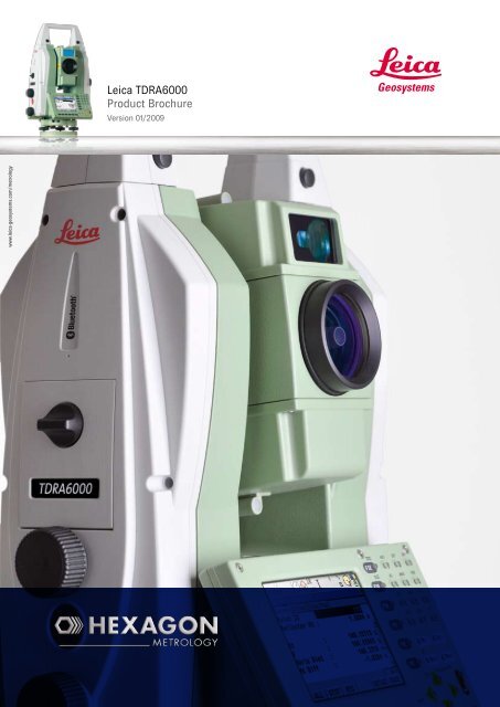
<strong>Leica</strong> <strong>TDRA6000</strong><strong>Product</strong> <strong>Brochure</strong>Version 01/2009www.leica-geosystems.com/metrology
The Laser Station<strong>Leica</strong> <strong>TDRA6000</strong>The <strong>Leica</strong> <strong>TDRA6000</strong> Laser Station is a portableinspection system designed for precision measurementson extremely large structures. It has an operationalvolume of 600 meters measuring 3d coordinatesboth with standard reflectors, and non-contact(reflectorless). The <strong>Leica</strong> <strong>TDRA6000</strong> sets a newstandard for ultra large scale metrology.<strong>Leica</strong> Geosystems introduced the world to Industrial TotalStations in 1983 with the legendary TC2002. In 1995 weintroduced the TPS5000 series as the world’s first fullyautomated tracking Industrial Total Station. For decades,<strong>Leica</strong> Geosystems has supplied thousands of IndustrialTheodolites and Total Stations worldwide – many in thetoughest industrial environments imaginable, indoorsand outdoors. Their ease of use and one-man operationcapability make them the obvious choice for a large varietyof metrology tasks in aerospace and shipbuilding as wellas general precision applications. We have spent the last25 years perfecting the Total Station for use in industrialenvironments, and the latest <strong>Leica</strong> Geosystems LaserStation incorporates everything that we have learned alongthe way.
A new level of speed andperformanceThe all new <strong>Leica</strong> Geosystems proprietary direct drivetechnology has been designed from the ground up for thissensor. Based on piezo technology, these new direct drivesenable high speed motorization and acceleration, at up to4x our previous generation, but still allow sub micron levelfine positioning. This revolutionary piezo technology hasvery low power consumption and because there are nogears, the drives require almost no maintenance, and arenear silent.A new high speed absolute angle encoder paired withour 4th generation Automatic Target Recognition (ATR)technology give the <strong>Leica</strong> <strong>TDRA6000</strong> Laser Station thebest tracking performance in its class. This new quadrupleangle detection system is accurate to 0.5 Arc Seconds (1σ)and is capable of 5000 measurements per second. TheATR and encoder feedback loop has been optimized for usewith 1.5” corner cube reflectors and is specially tuned foruse in a 600m volume.Light source (LED)coded glass circleCCD-arrayThe PinPoint Reflectorless Distance Meter allows noncontactmeasurements within the full 600 m volume,and has a very small visible beam that allows precisionmeasurements on difficult surfaces. This new EDM is basedon our proven System Analyzer technology that takesadvantage of both phase and time-of-flight information. TheSystem Analyzer accuracy is further enhanced (specificallyon corner cube reflectors) by passing the laser beamthrough a new anamorphic lens. This lens reshapes thebeam with an optimized profile and footprint allowing theinhomogeneous peripheral light to be cut off from the laserbeam completely.
Industrial grade measurementsWith a typical 3D point uncertainty of 0.25 mm in a30 meter volume, the new Laser Station <strong>Leica</strong> <strong>TDRA6000</strong>is the most accurate Total Station ever designed forindustrial use. Automatic Target Recognition allowsthe sensor to perform automated deformation studies,as well as track a reflector for single man operations.While the PowerSearch module makes re-locking on toan interrupted reflector as easy as standing still.Ship BuildingWith a measurement volume of up to 600m with anoncontact distance meter, the Laser Station <strong>Leica</strong><strong>TDRA6000</strong> is positioned for any challenge, even thegigantic ship building industry. When paired withmetrology focused software solutions designed tomaximize the measurement throughput, no other sensorcan compare to the <strong>Leica</strong> Laser Station’s range or accuracy.Machinery and Roller Alignment<strong>Leica</strong> Industrial Total Stations have been used for decadesfor accurate positioning and inspection of industrialmachinery like tire building machines, and processassembly machines. Our sensors have also been thecornerstone of precision roller alignment applications foreaqually as long. Whether you are inspecting or aligningsteel mills or paper mills the Laser Station <strong>Leica</strong> TDRA600is the sensor for you.
Railway ManufacturingThe process of manufacturing and routine inspection fortoday’s modern trains is not as simple as it used to be.The railway industry has tighter tolerances and higherthroughput than ever before. With functions like noncontactmeasurements (reflectorless) and the highestspeed automation on the market, there is no better railwayperformer than the Laser Station <strong>Leica</strong> <strong>TDRA6000</strong>.Power GenerationWind, Solar and Nuclear power all rely on high accuracylarge volume measurements to make sure that theequipment performs at its maximum potential. Whetheryou are erecting towers or inspecting blades for windturbines, laying out solar mirror fields, or inspectingNuclear reactor retrofits, the precision and flexibility of theLaser Station will be welcome changes to your daily work.Aerospace and Accelerator AlignmentThe tightest tolerances require the most precise sensors,and the Laser Station <strong>Leica</strong> <strong>TDRA6000</strong> is the most accurateof its kind. This is not just a surveying Total Station usedfor metrology applications, it is an Industrial Laser Stationdesigned for the most demanding and highest accuracyjobs.
Targets and AccessoriesWith a collection of different metrology grade reflectors, adaptersand accessories, the Laser Station <strong>Leica</strong> <strong>TDRA6000</strong> can beequipped to measure almost anything.Tripods and StandsWhether you work indoors or out, the stability of your setup isparamount. Therefore <strong>Leica</strong> Geosystems has a selection of tripodsto make sure that your specific job needs can be fulfilled.
<strong>Leica</strong> <strong>TDRA6000</strong> Laser Station AccuraciesAll measurements are performed under stable indoor environmentalconditions with the target squarely aligned. Distance measurementsare verified against a laser interferometer over 120 m. Unless statedotherwise, all accuracies are Maximum Permissible Error (≈ ±3 σ),with typical accuracies being ½ MPE (or approximately ±1.5 σ).3D Point AccuracyThe measurement uncertainty of a coordinate “U xyz” is defined as thedeviation between a measured coordinate and the nominal coordinateof that point. This measurement uncertainty is specified as a functionof the distance between the Laser Station and the measured point.The accuracy specified below is achieved with <strong>Leica</strong> Geosystems1.5” Red Ring reflectors and the “Precise” measurement mode. Specificationsare stated in Maximum Permissible Error (MPE). Typical resultsare ½ MPE.U xyz≤ 30 m volumeU xyz> 30 m volume± 0.5 mm ± 0.3 mm + 13 µm/m3D Point ReproducibilityThe 3D Point Reproducibility “P re” is defined as the standard deviationbetween multiple measurements of a 3D point and is specified as afunction of the distance between the LaserStation and the measuredpoint. The accuracy specified below is achieved with <strong>Leica</strong> Geosystems0.5” TBR and/or RFI reflectors using the “Precise” measurement mode.P re≤ 30 m volume ± 0.2 mmEDM PerformanceEDM Performance 1.5” 0.5” Reflective NonRRR & BRR 2 TBR & RFI 2 Tape 3 Contact (RL) 4Max Volume 600 m 600 m 600 m 600 mMin Distance 2.0 m 2.0 m 5.0 m 2.0 mAccuracy (MPE) 1 0.5 mm 0.5 mm 1.0 mm 2.0 mm1Accuracy shown is Maximum Permissible Error (MPE). Typical results are 1/2 MPE.2The 1.5” RRR is measured on the laser rail as standard.320 mm x 20 mm target from 5 m to 60 m.4RL measurements are done against the laser rail from 2 to 60 mPower Search PerformancePower Search PerformanceMax VolumeMin DistancePositioning time 11 200 gon to full ATR Lock1.5” RRR & BRR100 m2.0 m< 5 secondsATR PerformanceATR 1.5” 0.5” ReflectivePerformance RRR & BRR TBR & RFI 2 TapeMax Volume 600 m 400 m 40 mMin Distance 2.0 m 2.0 m 5.0 mAccuracy (MPE) 1 ± 0.3 mm + 13 µm/m N/A ± 2.0 mm1Accuracy shown is Maximum Permissible Error (MPE). Typical results are 1/2 MPE.2TBR & RFI reflectors can be used for point reproducibility (i.e. deformation studies).General InformationTelescope MagnificationFocusing range30 x1.7 m to infinityKeyboard and Display Display: ¼ VGA, color, touch, both facesKeyboard: 34 keys, illuminatedData storage Internal memory: 256 MBMemory card: CompactFlash card 256 MB or 1 GBInterfacesOperationRS232, Bluetooth ® WirelessThree endless drives for one ortwo hand operation Precisiontrigger key for manualmeasurementsPower Management Internal: lithium-ion batteryExternal: AC power supplyWeight Laser Station incl. battery7.6 kgEnvironmental specificationsOperating temperatureDust/waterHumidity–20° C to +50° C(IEC 60529) IP5495%, non-condensing
Whether building the fastest car, the biggestplane, or the most precise tooling, you needexact measurements to improve qualityand productivity. So when it has to beright, professionals trust <strong>Leica</strong> GeosystemsMetrology to help collect, analyze, andpresent 3-dimensional (3D) data for industrialmeasurement.<strong>Leica</strong> Geosystems Metrology is best knownfor its broad array of control and industrialmeasurement products including laser trackers,Local Positioning Technology (LPT) basedsystems, hand-held scanners, 3D software andhigh-precision total stations. Those who use<strong>Leica</strong> Metrology products every day trust themfor their dependability, the value they deliver,and the world-class service & support that’ssecond to none.Precision, reliability and service from <strong>Leica</strong>Geosystems Metrology.<strong>Leica</strong> GeosystemsMetrology <strong>Product</strong>sMoenchmattweg 5CH-5035 UnterentfeldenSwitzerlandPhone +41 62 737 67 67Fax +41 62 737 68 68www.leica-geosystems.com/metrologywww.hexagonmetrology.com© 2009 Hexagon ABAll rights reserved.774870Due to continuing product development, HexagonMetrology reserves the right to change productspecifications without prior notice.Printed in Switzerland. July 2009