delayed. Efforts to conduct interviews and theinformation gathered in the interviews should bedocumented in the heritage assessment report.Under O. Reg. 359/09, the municipality in whichthe renewable energy project is to be located isrequired to identify any heritage or archaeologicalresources at the project location on theirMunicipal Consultation Form, which is submittedto MOE in keeping with the consultationrequirements for REA. The person conducting theheritage assessment should make a best practice<strong>of</strong> reviewing this document to ensure that allheritage resources indicated by the municipalityhave been addressed in the heritage assessmentreport.For more information please refer to MOE’sTechnical Guide to Renewable Energy Approvalswhich provides guidance on preparing theconsultation report, and MOE’s Draft AboriginalConsultation Guide.3) Screening and Inventory:Conducting a screening and preparing a culturalheritage inventory is an important step in theheritage assessment process. The principleobjective <strong>of</strong> the screening is to take stock <strong>of</strong> allknown and potential heritage resources and toidentify the number, type, and location <strong>of</strong>buildings, structures, landscapes and/or featuresthat could be considered to be <strong>of</strong> potential culturalheritage value.The heritage assessment report should clearlyoutline the methodology used for conducting thescreening and identify preliminary screeningcriteria such as age, theme, or category (e.g., thenumber and location <strong>of</strong> farm complexes, rivers,roads or settlements).There are two types <strong>of</strong> surveys that should beconducted during the screening phase: the first isa desktop survey, which involves conductingpreliminary research using readily availablesources, such as Illustrated Historical Atlases andpublished histories. The second is a windshieldsurvey, where a large area is observed by drivingand noting particular landscapes, views, buildingsand structures within the study area.Once potential heritage resources have beenidentified, the information should be organized intoan inventory. The inventory should includephotographs and preliminary historical informationdetermined during the screening. Further researchand evaluation against O. Reg. 9/06 under theOntario <strong>Heritage</strong> Act (“Criteria for Determining<strong>Cultural</strong> <strong>Heritage</strong> Value or Interest”) is required todistinguish which <strong>of</strong> the inventoried resources areheritage resources that should be consideredfurther in the heritage assessment (see section2.3: Evaluation). A summary <strong>of</strong> all heritageresources identified at this stage should beprovided in the heritage assessment report alongwith a rationale for those resources screened outduring this step.4) Site Visit:The purpose <strong>of</strong> the site visit or windshield surveyis to record and analyze the physicalcharacteristics <strong>of</strong> the project location and todevelop knowledge <strong>of</strong> the landscape and context<strong>of</strong> the heritage resources.The qualified person should make a visual andwritten record <strong>of</strong> each building, structure orlandscape in sufficient detail to clearly illustratesignificant features. Descriptions should be clearand concise and touch on all significant features,and photographs should accompany a brief writtenpr<strong>of</strong>ile <strong>of</strong> each heritage resource. Photographsshould be cross-referenced to vantage pointsmarked on plans and should include compasspoint references for each view.Photographs <strong>of</strong> buildings and structures shouldprovide information on massing, materials,architectural features such as wall design, ro<strong>of</strong>shape, windows, property layout, principle viewsand the setting <strong>of</strong> the building and relationshipbetween the building or structure and thesurrounding landscape. For example, photographsshould show: principle elevation and at least one sideelevationperspective views <strong>of</strong> rear, front and sidegeneral view from a distance sufficient toshow setting, landscape and adjacentbuildingsif relevant, detailed views <strong>of</strong> importantcomponents such as entrances, windows,structural components, and/or technologicalfeatures such as machinery and equipmentFor landscapes, multiple views and perspectivesshould be recorded and photographed.Topography, elevations, and any significant manmadeor natural features which may provide cluesto the historical development and character <strong>of</strong> the8
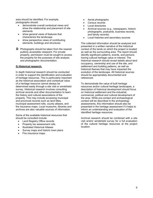
area should be identified. For example,photographs should: demonstrate overall contextual views andshow the relationship and placement <strong>of</strong> siteelements show general views <strong>of</strong> features thatcharacterize the landscape show perspective views <strong>of</strong> contributingelements, buildings and structures Photographs should be taken from the nearestpublicly accessible viewpoint. For privateproperty, permission must be sought to accessthe property for the purposes <strong>of</strong> site analysisand photographic documentation.5) Historical research:In depth historical research should be conductedin order to support the identification and evaluation<strong>of</strong> heritage resources. This is particularly importantas the historical association and contextual value<strong>of</strong> a heritage resource cannot always bedetermined easily through a site visit or windshieldsurvey. Historical research involves consultingarchival records and other documentation to learnthe history and cultural associations <strong>of</strong> theproperty. This may include accessing municipaland provincial records such as land titles,municipal assessment rolls, county atlases, andfire insurance maps. Local museums, libraries andarchives are also valuable sources <strong>of</strong> information.Some <strong>of</strong> the available historical resources thatshould be consulted include: Land Registry Office records Property tax assessment rolls Illustrated Historical Atlases Survey maps and historic town plans Fire insurance mapsAerial photographsCensus recordsLocal directoriesArchival sources (e.g., newspapers, historicphotographs, postcards, business records,and family records)Local histories and secondary sourcesThe collected information should be analyzed andpresented in a written narrative <strong>of</strong> the historicalcontext <strong>of</strong> the lands on which the project is locatedas well as the surrounding area. The report shouldidentify significant patterns, events, and personshaving cultural heritage value or interest. Thehistorical research should reveal details about landoccupancy, ownership and use <strong>of</strong> the site, andsettlement and building patterns, as well ashistorical themes that may have impacted theevolution <strong>of</strong> the landscape. All historical sourcesshould be appropriately documented andreferenced.To demonstrate the value <strong>of</strong> built heritageresources and/or cultural heritage landscapes, adescription <strong>of</strong> historical development should focuson historical settlement and the industrial,commercial, political and cultural development <strong>of</strong>the area. While pre-contact and archaeologicalcontext will be described in the archaeologyassessments, this information should also bepresented in the heritage assessment if it helps toinform an understanding and evaluation <strong>of</strong> theidentified heritage resources.Archival research should be combined with a sitevisit and/or windshield survey for a full evaluation<strong>of</strong> the cultural heritage resources at the projectlocation.9


![THIS AGREEMENT made this [date], between [name of owner] (the ...](https://img.yumpu.com/49827605/1/158x260/this-agreement-made-this-date-between-name-of-owner-the-.jpg?quality=85)