KETCHIKAN GATEWAY BOROUGH PLANNING COMMISSION ...
KETCHIKAN GATEWAY BOROUGH PLANNING COMMISSION ...
KETCHIKAN GATEWAY BOROUGH PLANNING COMMISSION ...

You also want an ePaper? Increase the reach of your titles
YUMPU automatically turns print PDFs into web optimized ePapers that Google loves.
<strong>KETCHIKAN</strong> <strong>GATEWAY</strong> <strong>BOROUGH</strong><strong>PLANNING</strong> <strong>COMMISSION</strong>/PLATTING BOARD6:00 p.m. MEETING DOCKET October 9, 2012A COMPLETE AGENDA PACKET WILL BE AVAILABLE ON THE <strong>BOROUGH</strong> WEBSITE AThttp://www.kgbak.us ON THE FRIDAY PRECEDING THE <strong>PLANNING</strong> <strong>COMMISSION</strong> MEETINGComments or concerns regarding a proposal may be emailed to planning@kgbak.us.Please cite the case number.To be included in the staff report, your comments must be received by October 1, 2012. Commentsreceived after this date will be given to the Planning Commission at the meeting.Case 12-043 is a Request for a Major Variance to Allow an Existing Detached Accessory Dwelling Unit(DADU) to be Expanded to Exceed the Maximum Gross Floor Area of 720 Square Feet by 288 SquareFeet and to Exceed the Maximum Height Limit of One Story by One Story to Create a 1008 Square Foot,Two Story DADU at 8476 South Tongass Hwy. (Resolution No. 3552)SUMMARYThe applicant has an existing, permitted DADU on his property. The existing DADU is one story in heightand contains 240 square feet of gross floor area. The applicant wants to make the DADU larger byincreasing the footprint of the building and adding a second story to it. The foundation footprint of theproposed DADU will not exceed the maximum size allowed, but combing the floor area of the ground floorwith that of the second story is what will create the need for a variance to the maximum square footage.Adding the second story will also increase the height of the DADU above the maximum one story andcreate the need for a variance to that dimension also. This case was originally heard at the June 12,2012Planning Commission meeting where it was continued to the October 9, 2012 meeting.Case 12-083 is a Petition by the Ketchikan Gateway Borough to Vacate a Portion of Narrows Lane. Theadjoining properties that are party to this vacation are known as Lots 18, 19, 20, 24, 25, and 26, USS1417, along Narrows Lane, City of Ketchikan.SUMMARYThe request is to vacate a portion of Narrows Lane located near the 6 mile marker of North TongassHighway. The request will be heard by the Planning Commission then if approved by the City Council.If the City Council does not veto the request, the vacation will be followed up by a plat alteration,amending the adjacent properties' boundaries to coincide with the vacation.Case 12-084 is a request by Olson Marine Inc. for a three year Conditional Use Permit to allow a mobilebuilding to be used as an office at 5569 N. Tongass Highway on Tract A of Alaska Tidelands Survey 78.SUMMARYOlson Marine Inc. has a mobile building on their property that they want to use as an office. The mobilewas used as an office at their former location in the Ward Cove area. The structure will be used forcommercial purposes only and will contain no residential use.Case 12-085 is a request by Richard and Hillary Robbins for a Major Variance to allow an existing single
Case 12-085 is a request by Richard and Hillary Robbins for a Major Variance to allow an existing singlefamily dwelling and attached accessory garage and recreation room to remain and encroach up to twelve(12) feet into the required fifteen (15) foot side yard setback along the northwest property line, and toallow the accessory structures to be increased in height from one to two stories, and to allow the foot printof the recreation room to be expanded from 18 feet by 20 feet to 40 feet by 22 feet, at 504 Sunset Drive onU. S. Survey 2343, Tract I, Lot 1A-1.SUMMARYThe Robbins own a home with an attached garage and recreation room that a previous owner built tooclose to the property line. The walls of the encroaching structures run parallel to the northwest propertyline. The requested variance will bring the existing home into compliance. The applicant also wants toexpand the size of the recreation room by adding a 22' x 22' addition that will extend the encroaching wallan additional 22' parallel to the northwest lot line. The addition will also increase the height of both thegarage and the recreation room by a second story. The purpose of the addition is to create a separatedwelling unit the applicant can use as a separate residence when he works graveyard shifts.Case 12-087 is a request by the Ketchikan Gateway Borough for a Major Variance to allow a municipaltransit bus shelter to be constructed an encroach ten (10) feet into the required ten (10) foot front yardsetback at 1200 Woodside Drive; Tract A of the Bear Valley Addition to U.S. Mineral Survey 769.SUMMARYThe Ketchikan Gateway Borough Transit Department wants to build a bus shelter in front of theWoodside Village apartment complex. There is not enough room in the Schoenbar ROW to build theshelter, so a portion of it needs to be placed on the adjacent private property. The shelter will straddle theproperty boundary between the ROW and the private property, thereby creating an encroachment andrequiring a variance.Case 12-088 is a request by the Ketchikan Gateway Borough for a Major Variance to allow a municipaltransit bus shelter to be constructed an encroach ten (10) feet into the required ten (10) foot front yardsetback at 3221 Baranof Ave.; U.S. Survey 1591, Block 15, Lot 4.SUMMARYThe Ketchikan Gateway Borough Transit Department wants to build a bus shelter in front of the TlingitHaida senior housing complex. There is not enough room in the Baranof ROW to build the shelter, so aportion of it needs to be placed on the adjacent private property. The shelter will straddle the propertyboundary between the ROW and the private property, thereby creating an encroachment and requiring avariance.The Planning Commission will Review Title 55 and Title 60, now Title 17 and Title 18 of, the RevisedProof of the Reorganized KGB Code, Including Title 55 Subdivisions and Title 60 Zoning, as Drafted byCode Publishing Inc.The Complete Revised Proof of the Reorganized KGB Code may be viewed at:http://www.codepublishing.com/downloads/kgb.htmlThe Planning Commission will hold a Work Session for a Text Amendment to Title 60 to Allow Float PlaneOperations as a Conditional Use Permit in the General Commercial (CG) Zone and Light Industrial (IL)Zone.
3ACKNOWLEDGMENTSThis work has been funded by a grant (6D016-081841/001/SS) from the Public Health Agency of Canada.The following institutions (in alphabetical order) and representatives contributed to this study:• Alberta Institute of Health Economics—Phil Jacobs• Canada Northwest Fetal Alcohol Spectrum Disorder Partnership (CNFASDP) Research Network—JanLutke• Correctional Service Canada, Addictions Research Centre—Patricia Macpherson• First Nations and Inuit Health Branch—Tanya Churchill• Justice Canada, Research and Statistics Division—Charlotte Fraser• National Center on Birth Defects and Developmental Disabilities, Centers for Disease Control andPrevention—Louise Floyd• National Institute on Alcohol Abuse and Alcoholism—Kenneth Warren• Public Health Agency of Canada—Alan Diener, Mary Johnston, Holly MacKay and Heather Caughey• University of Manitoba—Don Fuchs• World Health Organization, Department of Mental Health and Substance Abuse—Vladimir PoznyakThe authors are grateful to these organizations for their generous support and contributions; however,any errors or omissions in this report are the sole responsibility of the authors.© 2012 CAMH
Staff reportNotice Area MapPON List
Upon roll call the vote on the MOTIONYES:PAINTER, PHILLIPSNO:BAILEY, MORAN, ROTECKI, SAMOTION DECLARED FAILEDUpon roll call the vote on the AMENDYES:BAILEY, ROTECKI, SALAZAR, PNO:MORAN, PHILLIPS, THOMPSOMOTION DECLARED CARRIED
Assemblymember Thompson requestand one roof was one sale, but withde- facto subdivision. He wanted to sAssemblymember Rotecki believed thwas not in favor of the low- density rthat something between medium- denUpon roll call the vote on the MOTIONYES:ROTECKI, THOMPSON, MORAMOTION DECLARED CARRIEDScheduled Informational Reports abudgets, audits, and reports or planning docume
K E T C H I K A N G A T E W A Y B O R O U G HPlanning Commission/Platting Board Meeting Minutes June 12, 2012The regular meeting of the Ketchikan Gateway Borough Planning Commission/Platting Boardwas called to order at 6:00p.m., Tuesday, June 12, 2012, by Gregg Poppen, Chair, and roll wascalled.CALL TO ORDER - ROLL CALL – PLEDGE OF ALLEGIANCE.PRESENT: DEAL, POPPEN, MECK, DOHERTY, MEDFORD, HARRINGTON…Case 12-043 is a Request for a Major Variance to Allow an Existing Detached AccessoryDwelling Unit (DADU) to be Expanded to Exceed the Maximum Gross Floor Area of 720 SquareFeet by 288 Square Feet and to Exceed the Maximum Height Limit of One Story by One Storyto Create a 1008 Square Foot, Two Story DADU at 8476 South Tongass Hwy. (Resolution No.3552)Principal Planner French summarized the written staff report.Member Harrington asked the size of the lot. Principal Planner French replied over two acres.Member Deal asked if there was a road to the DADU. Principal Planner French said there wasonly a path to the dwelling.The applicant, Sharon Geldaker, explained that when her husband bought the property, therewere two structures on the property, the house and the DADU. The house was a small singlestory cabin to which he added a second story. Even with the addition, the primary home was stillsmall. Because he kept the original footprint, the size of the primary dwelling was limiting thesize of the DADU. Ms. Geldaker said she and her husband traveled extensively, so they rentedout the main house and stayed in the DADU when they were in Ketchikan. She stated that theywere not adding any bedrooms to the DADU, but they were trying to expand the size of thebuilding to make their living quarters less cramped.M/S HARRINGTON/MEDFORD to adopt Resolution 3552ANo findings were proposedMotion WITHDRAWNM/S DEAL/MEDFORD to adopt Resolution 3552 B as presented.Member Harrington said because of the size of the lot, what they were planning made sense.Director Williams explained that staff agreed that the proposal was fine, but it would be verydifficult if not impossible to write findings in support of the request because of text in the Codeon CUP review and DADU standards.Member Deal asked Ms. Geldaker how much of a hardship it would be to the couple if they hadto wait until the Borough cleaned up the Code to allow the Commission to approve thePlanning Commission/Platting BoardJune 12, 2012 1
expansion they were seeking. She said it would not be a financial hardship, but they would liketo continue to work on site preparation. If continued site prep was possible, it would be okay todelay the decision.Principal Planner French mentioned that the reason staff recommended denial of the variance,but approval on the CUP, was to deny the variance for area and height, so that the PlanningCommission could give staff direction on a text amendment to Title 60. The recommendedapproval of the CUP on the following case by the same applicants was to allow them someability to prepare the site while they wait for a change in the code.Member Deal said he would rather see the Planning Commission change something in the KGBCode than make an exception for the variance as presented.The Commission asked staff to research and develop a text amendment to address detachedduplexes and the current design standards for DADUs and bring to the Commission at theregular July meeting.Upon roll call, the vote on the MOTION was:YES: DEALNO: DOHERTY, HARRINGTON, MECK, MEDFORD, POPPENMOTION DECLARED FAILEDM/S HARRINGTON/MEDFORD to reconsider Resolution 3552 B.Upon roll call, the vote on the MOTION was:YES: DEAL, DOHERTY, MEDFORD, MECK, HARRINGTON, POPPENMOTION DECLARED CARRIEDM/S HARRINGTON/MECK to table the motion until the regular meeting in October.Upon roll call, the vote on the MOTION was:YES: DEAL, POPPEN, MECK, DOHERTY, MEDFORD, HARRINGTONMOTION DECLARED CARRIEDADJOURNMENT…The meeting adjourned at 9:23p.m.__________________________Alethea JohnsonPlatting/Zoning Clerk_____________________________Gregg Poppen, ChairPlanning Commission/Platting BoardPlanning Commission/Platting BoardJune 12, 2012 2
K E T C H I K A N G A T E W A Y B O R O U G H<strong>PLANNING</strong> <strong>COMMISSION</strong>/PLATTING BOARDRESOLUTION NO. 3552 BA Resolution of the Ketchikan Gateway Borough Planning Commission Denying aRequest by Stan Berntson and Sharon Geldaker for a Major Variance to Allow anExisting Detached Accessory Dwelling Unit (DADU) to be Expanded to Exceed theMaximum Gross Floor Area of 720 Square Feet by 288 Square Feet and to Exceed theMaximum Height Limit of One Story by One Story to Create a 1008 Square Foot, TwoStory DADU at 8476 South Tongass Hwy. (Case 12-043)FINDINGS1. The Planning Commission found that this request is not in the best interests of theresidents of the Ketchikan Gateway Borough.2. The conditions requiring the variance being sought are created by the applicant.3. The subject parcel is not subject to greater hardship or burden as compared tosurrounding properties.4. The requested variance is not the minimum required.NOW, THEREFORE, IN CONSIDERATION OF THE ABOVE FINDINGS, IT ISRESOLVED BY THE <strong>PLANNING</strong> <strong>COMMISSION</strong>/PLATTING BOARD OF THE <strong>KETCHIKAN</strong><strong>GATEWAY</strong> <strong>BOROUGH</strong>, ALASKA, as follows:SECTION 1: That the request for a Major Variance to allow an existing detached accessorydwelling unit to be expanded to exceed the maximum gross floor area of 720 square feet by288 square feet and to exceed the maximum height limit of one story by one story to create a1008 square foot, two story Detached Accessory Dwelling Unit (DADU), be DENIED, subject tothe findings of fact contained herein.
RESOLUTION 3552 B PAGE 2 OF 2PASSED AND ADOPTED this 12th of June, 2012.EFFECTIVE DATE: June 12, 2012ROLL CALL Yes No AbsentGregg Poppen, ChairmanPlanning Commission/Platting BoardDEALDOHERTYHARRINGTONATTEST:Alethea Johnson, Platting/Zoning ClerkKetchikan Gateway BoroughMECKMEDFORDPOPPEN[VACANT]MOTION DECLARED CARRIED
Part I.GENERAL INFORMATIONMeeting Date: 6/12/12Case Number: 12-043Requested Action:Applicant/Owner(s):Survey/Address:Request for a Major Variance to allow an existing detachedaccessory dwelling unit to be expanded to exceed the maximumgross floor area of 720 square feet by 288 square feet and toexceed the maximum height limit of one story by one story to createa 1008 square foot, two story Detached Accessory Dwelling Unit(DADU).Stan Bernston and Sharon GeldakerU.S. Survey 2403, Tract A, Lot 91B / 8476 S. Tongass Hwy.Parcel No.: 70-2430-004-000Zoning:Low Density Residential ZoneApplicable Regulations:Section 60.10.035 Low Density Residential ZoneSection 60.10.116 Standards for Detached Accessory Dwelling UnitsSection 60.10.120 VariancesA. Interested Individuals Comments:1. NoneB. Agency Comments1. NoneSummary: Case 12-043 is request for a Major Variance to allow an existing detachedaccessory dwelling unit to be expanded to exceed the maximum gross floor area of 720square feet by 288 square feet and to exceed the maximum height limit of one story by onestory to create a 1008 square foot, two story DADU. Staff recommends denial of Case 12-043.
Part II.BACKGROUNDThe applicant requests a major variance to allow an existing 240 square foot DADU to be expandedto be larger than the maximum allowed size by 288 square feet and to be more than one story inheight. The existing DADU was permitted by a CUP and built by the applicant. An application for aCUP to allow the addition has also been submitted and will be considered concurrently with thisvariance. The property is located within the low density residential zone (RL).According to the applicants, they primarily live in the DADU and rent the main house. After living withthis arrangement for several years, the applicants have realized that 240 square feet is simply notlarge enough to be comfortable. In order for the applicants to have a living area of adequate size fornow and in the future, they would like the DADU to have a gross floor area of 978 square feet and beone and a half stories tall. A DADU is limited in size to 800 square feet or 40% of the gross floor areaof the principal dwelling, and can only be one story in height unless it is on top of another accessorybuilding such as a garage. The principal dwelling on the property is 1,800 square feet in gross floorarea, which would allow a DADU to be 720 square feet. The proposed DADU would exceed themaximum gross floor area by 288 square feet and exceed the height limit by one story.The second story is actually what is commonly referred to as a half story as the outside walls will bethe roof. In addition to adding more living area to the DADU, the applicant wants the second floor tomake the building more architecturally similar to the principal dwelling. The principal dwelling is oneand a half stories tall and contains roof dormers. The proposed addition would incorporate roofdormers into the design. The zoning code does not contain provisions for half stories, so even thoughthe proposed addition is one and a half stories in height, it must be considered two stories for thepurpose of requesting a variance.The foundation of the proposed addition would have a foot print of 16’ by 24’, or 384 square feet.Combined with the existing DADU, the foundation of the structure would cover 624 square feet. The978 square feet of gross floor area of the proposed DADU results from the two floors of the additionbeing 384 square feet each, for a total of 768 square feet, and the existing DADU being 240 squarefeet.The applicant admittedly could build an addition to the existing DADU that conforms to the size andheight limits. They are asking for variances to the development standards in part to make the DADUmore aesthetically pleasing. A conforming structure would be long and narrow because of thedevelopment constraints of the subject parcel. The narrow dimensions of the foot print for the additionare caused by a relatively narrow building area that is constrained by a rock slope on the upland side,and a seawall on the water side. When the applicant first approached Planning staff with the idea ofsubmitting a variance, Planning staff was clear that their request could not be supported because theapplicant is creating the need for the variance. In response, the applicant submitted drawings toreflect two other potential configurations for the DADU. Option A, shown in the “Application” section,shows the preferred alternative that is described above. Option B shows the DADU with an addition
that exceeds one story in height, but does not exceed the gross floor area limit. For the CUPapplication, another option was submitted that does not exceed either the height or square footagelimits. The applicants submitted this last drawing in the event the Commission chose to deny thevariance request.The Option B version would be two stories, with the second story having the sloped walls of the roof,and a 16’ by 15’ (240 square feet) footprint. The gross floor area of the addition would be 480 squarefeet (2 floors at 240 square feet each), combined with the existing 240 square foot DADU would resultin 720 square feet of gross floor area. An unheated storage area for firewood would be constructedon the side that would not be calculated in the gross floor area of the DADU.The applicant is creating the need for this variance through their desire to build a structure larger andtaller than the code allows. For that reason, staff cannot support the proposed variance. TheCommission has the authority to interpret the more subjective standards for granting variances aswell as to consider factors such as aesthetics and impact that Planning staff cannot when evaluatingcases. The Commission can also grant portions of the applicant’s request such as allowing the heightvariance, but not the square footage.Summary & RecommendationPlanning staff recommends denial of this request for a major variance to allow an existing DADU tobe expanded to exceed the height and gross floor area limits contained in 60.10.116. The need forthe proposed variance is caused by the applicant, and the requested variance is not the minimumnecessary to provide substantial relief.Part III.REVIEW OF APPLICABLE CRITERIAA. A variance from a quantifiable standard may be granted in accordance with the reviewprocedures provided in subsection 60.10.120(C)(6) provided the applicant providesevidence that the following standards are met:A.1:Special conditions that require the variance are not caused by the person seeking thevariance;The need for the variance is created by the applicant’s desire to construct a larger and tallerstructure than is permittable.Finding A.1: The conditions requiring the variance being sought are created by the applicant.A.2:The variance will not permit a land use in a district in which that use is prohibited;The DADU is a permitted accessory use to the primary use of the site as a single familyresidence that is permitted within the RL zone.Finding A.2: The variance will not permit a land use that is prohibited.
A.3:The variance will not solely relieve a pecuniary hardship or inconvenience.Finding A.3: The variance is to allow the current accessory structure to be expanded into aform that is architecturally consistent with the principal dwelling.A.4:When compared with other properties in the surrounding area, the property is subject to agreater hardship or burden resulting from the strict application of the zoning ordinance;The subject parcel is much larger than most of the adjacent parcels, which have similartopographical constraints.Finding A.4: The subject parcel is not subject to greater hardship or burden as compared tosurrounding properties.A.5:The requested variance is the minimum reduction of development requirements necessaryto give substantial relief to the property involved.At the applicant’s admission, an addition could be made to the DADU that would not requirea variance to size or height requirements.Finding A.5: The requested variance is not the minimum required.Part IV.STAFF RECOMMENDATIONStaff recommends for denial of Case 12-043; major variance to allow an existing detached accessorydwelling unit to be expanded to exceed the maximum gross floor area of 720 square feet by 288square feet and to exceed the maximum height limit of one story by one story to create a 1008 squarefoot, two story DADU.Part V.ATTACHMENTS
B. APPLICATION
Option A- Preferred alternative
Option B – exceeds height, but not square footage.
Conforming alternative submitted for CUP.
C. MAPS
D. PHOTOSThe existing principal dwelling and DADU as seen from the tide flats.
Owner_Name Address CITY STATEZIPBERALDI SALVATORE L & JOAN P 8381 S TONGASS HWY <strong>KETCHIKAN</strong> AK 99901BERNTSON ANDREW D 5643 S TONGASS HWY <strong>KETCHIKAN</strong> AK 99901BERNTSON STANLEY L & GELDAKER SHARO PO BOX 8416 <strong>KETCHIKAN</strong> AK 99901BOWER CURTIS & LOUISE A PO BOX 9163 <strong>KETCHIKAN</strong> AK 99901BRAME JAMES P JR PO BOX 7303 <strong>KETCHIKAN</strong> AK 99901BRAND DENNIS A & JANET A 8230 S TONGASS HWY <strong>KETCHIKAN</strong> AK 99901CASKEY ROBERT S PO BOX 1364 WARD COVE AK 99928CLARK COY S & EILEEN M 8366 S TONGASS HWY <strong>KETCHIKAN</strong> AK 99901CLIFTON JOHN 8400 S TONGASS HWY <strong>KETCHIKAN</strong> AK 99901FERNBACH ROBERT B PO BOX 6316 <strong>KETCHIKAN</strong> AK 99901JAUSORO MICHAEL L & DENISE M PO BOX 5125 <strong>KETCHIKAN</strong> AK 99901JURCZAK MICHAEL & PAULA 10 POWERHOUSE RD <strong>KETCHIKAN</strong> AK 99901KENOYER DONALD D & MARCIA D 6167 S TONGASS HWY <strong>KETCHIKAN</strong> AK 99901MCELROY PHILLIP G & JANIS L 1261 RIVERBEND LOOP RD CUSICK WA 99119O'CONNELL ANNETTE PO BOX 3187 KENAI AK 99611PFLAUM DAVID R & DEBRA JEAN 8256A S TONGASS HWY <strong>KETCHIKAN</strong> AK 99901RAUWOLF ANDREW B & PEGGY J 7942 S TONGASS HWY <strong>KETCHIKAN</strong> AK 99901RIDGEWAY JAMES A & SHIRLEY 6901 TANAINA RD ANCHORAGE AK 99502ROTTSCHAFER JANIS 8316 S TONGASS HWY <strong>KETCHIKAN</strong> AK 99901SCHELIN BRIAN L PO BOX 9176 <strong>KETCHIKAN</strong> AK 99901SCHROEDER RUSSELL D & REYNALDA C 114 WHITE MARLIN DR PORT ALTO TX 77979TOWNSEND GUY HOWARD 830 PETERSON ST <strong>KETCHIKAN</strong> AK 99901WEGMAN EDITH TRUSTEE 8630 S TONGASS HWY <strong>KETCHIKAN</strong> AK 99901WHALEN KIMBERLY S PO BOX 23298 <strong>KETCHIKAN</strong> AK 99901WHITESIDES DALE R 6716 ROOSEVELT DR <strong>KETCHIKAN</strong> AK 99901WOLF ALAN & ROSE LIVING TRUST PO BOX 791 KODIAK AK 99615
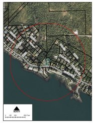
<strong>PLANNING</strong> <strong>COMMISSION</strong> DOCKETMeeting Date: 10/09/2012Case Number:InformationCase 12-083 is a Petition by the Ketchikan Gateway Borough to Vacate a Portion of Narrows Lane. Theadjoining properties that are party to this vacation are known as Lots 18, 19, 20, 24, 25, and 26, USS1417, along Narrows Lane, City of Ketchikan.SUMMARYThe request is to vacate a portion of Narrows Lane located near the 6 mile marker of North TongassHighway. The request will be heard by the Planning Commission then if approved by the City Council.If the City Council does not veto the request, the vacation will be followed up by a plat alteration,amending the adjacent properties' boundaries to coincide with the vacation.Public Comment:Comments or concerns regarding a proposal may be emailed to planning@kgbak.usPlease include the case number in your comment.12-083 Application12-083 Draft PlatAttachments
<strong>PLANNING</strong> <strong>COMMISSION</strong> DOCKETMeeting Date: 10/09/2012Case Number:InformationCase 12-084 is a request by Olson Marine Inc. for a three year Conditional Use Permit to allow a mobilebuilding to be used as an office at 5569 N. Tongass Highway on Tract A of Alaska Tidelands Survey 78.SUMMARYOlson Marine Inc. has a mobile building on their property that they want to use as an office. The mobilewas used as an office at their former location in the Ward Cove area. The structure will be used forcommercial purposes only and will contain no residential use.Public Comment:Comments or concerns regarding a proposal may be emailed to planning@kgbak.usPlease include the case number in your comment.12-084 ApplicationAttachments
607983Customer Number12‐084Permit NumberKetchikan Gateway Borough 2012‐09‐21Permit ApplicationApproved ByNEW ELECTRIC METERApplicant InformationOwnerOLSON MARINE INCSecond OwnerMailing Address PO BOX 1417; WARD COVE AK; 99928Applicant OLSON MARINE INC RelationshipPhone NumberWork NumberPreferred ContactEmail AddressContact By Email PreferredExisting Property InformationProperty Address N TONGASS HWY 5569ZoningNo DataLegal Description Tract A, of Alaska Tidelands Survey No. 78, according to the plat thereof recorded April 9, 1962 in Volume 1 of Plats at Packet No. 38,Ketchikan Recording District, First Judicial District, State of Alaska.Assessor's Parcel Number013230047100ATS1Proposed Project InformationPermit ExpiresLand UseDescriptionCase 12‐084 is a request by Olson Marine Inc. for a three year Conditional Use Permit to allow a mobile building to be usedas an office at 5569 N. Tongass Highway on Tract A of Alaska Tidelands Survey 78.TOTALPARKINGSPACESPROVIDED0ConditionsZPNRZONING PERMIT:NEW BUILDINGZONING PERMIT:NEW USE ONLYZONING PERMIT:MOBILE BUILDINGCORRESPONDENCETEMPORARY ZONING PERMITSIGN PERMITTHE BELOW APPLICATION(S) ARE REQUIRED:WATERCITY BUILDINGPERMITADEC APPROVALADOT DRIVEWAYPERMITKGB UTILITY HOOKUPSEWERSDC FEE
<strong>PLANNING</strong> <strong>COMMISSION</strong> DOCKETMeeting Date: 10/09/2012Case Number:InformationCase 12-085 is a request by Richard and Hillary Robbins for a Major Variance to allow an existing singlefamily dwelling and attached accessory garage and recreation room to remain and encroach up to twelve(12) feet into the required fifteen (15) foot side yard setback along the northwest property line, and toallow the accessory structures to be increased in height from one to two stories, and to allow the foot printof the recreation room to be expanded from 18 feet by 20 feet to 40 feet by 22 feet, at 504 Sunset Driveon U. S. Survey 2343, Tract I, Lot 1A-1.SUMMARYThe Robbins own a home with an attached garage and recreation room that a previous owner built tooclose to the property line. The walls of the encroaching structures run parallel to the northwest propertyline. The requested variance will bring the existing home into compliance. The applicant also wants toexpand the size of the recreation room by adding a 22' x 22' addition that will extend the encroaching wallan additional 22' parallel to the northwest lot line. The addition will also increase the height of both thegarage and the recreation room by a second story. The purpose of the addition is to create a separatedwelling unit the applicant can use as a separate residence when he works graveyard shifts.Public Comment:Comments or concerns regarding a proposal may be emailed to planning@kgbak.usPlease include the case number in your comment.12-085 ApplicationAttachments
601364Customer Number12‐085Permit NumberKetchikan Gateway Borough 2012‐09‐21Permit ApplicationApproved ByNEW ELECTRIC METERApplicant InformationOwnerROBBINS RICHARD T & HILLARYSecond OwnerMailing Address 504 SUNSET DR ; <strong>KETCHIKAN</strong> AK; 99901Applicant ROBBINS RICHARD T & HILLARY RelationshipPhone NumberWork NumberPreferred ContactEmail AddressContact By Email PreferredExisting Property InformationProperty Address SUNSET DR 504ZoningRLLegal DescriptionLot 1A‐1, Resubdivision of Lot 1, Tract I, U.S. Survey 2343, according to the plat thereof recorded as Plat No. 73‐9, Ketchikan RecordingDistrict, First Judicial District, State of Alaska.Assessor's Parcel Number 313440056000Proposed Project InformationPermit ExpiresLand UseDescriptionCase 12‐085 is a request by Richard and Hillary Robbins for a Major Variance to allow an existing single family dwelling andattached accessory garage and recreation room to remain and encroach up to twelve (12) feet into the required fifteen (15)foot side yard setback along the northwest property line, and to allow the accessory structures to be increased in heightfrom one to two stories, and to allow the foot print of the recreation room to be expanded from 18 feet by 20 feet to 40 feetby 22 feet, at 504 Sunset Drive on U. S. Survey 2343, Tract I, Lot 1A‐1.TOTALPARKINGSPACESPROVIDED0ConditionsZPNRZONING PERMIT:NEW BUILDINGZONING PERMIT:NEW USE ONLYZONING PERMIT:MOBILE BUILDINGCORRESPONDENCETEMPORARY ZONING PERMITSIGN PERMITTHE BELOW APPLICATION(S) ARE REQUIRED:WATERCITY BUILDINGPERMITADEC APPROVALADOT DRIVEWAYPERMITKGB UTILITY HOOKUPSEWERSDC FEE
<strong>PLANNING</strong> <strong>COMMISSION</strong> DOCKETMeeting Date: 10/09/2012Case Number:InformationCase 12-087 is a request by the Ketchikan Gateway Borough for a Major Variance to allow a municipaltransit bus shelter to be constructed an encroach ten (10) feet into the required ten (10) foot front yardsetback at 1200 Woodside Drive; Tract A of the Bear Valley Addition to U.S. Mineral Survey 769.SUMMARYThe Ketchikan Gateway Borough Transit Department wants to build a bus shelter in front of theWoodside Village apartment complex. There is not enough room in the Schoenbar ROW to build theshelter, so a portion of it needs to be placed on the adjacent private property. The shelter will straddle theproperty boundary between the ROW and the private property, thereby creating an encroachment andrequiring a variance.Public Comment:Comments or concerns regarding a proposal may be emailed to planning@kgbak.usPlease include the case number in your comment.12-087 ApplicationAttachments
607242Customer Number12‐087Permit NumberKetchikan Gateway Borough 2012‐09‐21Permit ApplicationApproved ByNEW ELECTRIC METERApplicant InformationOwnerBOSHOWSKI PROPERTIES LLCSecond OwnerMailing Address 2050 SEA LEVEL DR SUITE 107; <strong>KETCHIKAN</strong> AK; 99901Applicant BOSHOWSKI PROPERTIES LLC RelationshipPhone NumberWork NumberPreferred ContactEmail AddressContact By Email PreferredExisting Property InformationProperty Address WOODSIDE DR 1200ZoningRMLegal DescriptionTract A, Bear Valley Addition to U.S. Mineral Survey 769, according to the plat thereof filed March 17, 1973, as Plat No. 73‐8, KetchikanRecording District, First Judicial District, State of Alaska.Assessor's Parcel Number 011424000200Proposed Project InformationPermit ExpiresLand UseDescriptionCase 12‐087 is a request by the Ketchikan Gateway Borough for a Major Variance to allow a municipal transit bus shelter tobe constructed an encroach ten (10) feet into the required ten (10) foot front yard setback at 1200 Woodside Drive; Tract Aof the Bear Valley Addition to U.S. Mineral Survey 769TOTALPARKINGSPACESPROVIDED0ConditionsZPNRZONING PERMIT:NEW BUILDINGZONING PERMIT:NEW USE ONLYZONING PERMIT:MOBILE BUILDINGCORRESPONDENCETEMPORARY ZONING PERMITSIGN PERMITTHE BELOW APPLICATION(S) ARE REQUIRED:WATERCITY BUILDINGPERMITADEC APPROVALADOT DRIVEWAYPERMITKGB UTILITY HOOKUPSEWERSDC FEE
<strong>PLANNING</strong> <strong>COMMISSION</strong> DOCKETMeeting Date: 10/09/2012Case Number:InformationCase 12-088 is a request by the Ketchikan Gateway Borough for a Major Variance to allow a municipaltransit bus shelter to be constructed an encroach ten (10) feet into the required ten (10) foot front yardsetback at 3221 Baranof Ave.; U.S. Survey 1591, Block 15, Lot 4.SUMMARYThe Ketchikan Gateway Borough Transit Department wants to build a bus shelter in front of the TlingitHaida senior housing complex. There is not enough room in the Baranof ROW to build the shelter, so aportion of it needs to be placed on the adjacent private property. The shelter will straddle the propertyboundary between the ROW and the private property, thereby creating an encroachment and requiring avariance.Public Comment:Comments or concerns regarding a proposal may be emailed to planning@kgbak.usPlease include the case number in your comment.12-088 ApplicationAttachments
602776Customer Number12‐088Permit NumberKetchikan Gateway Borough 2012‐09‐21Permit ApplicationApproved ByNEW ELECTRIC METERApplicant InformationOwner<strong>KETCHIKAN</strong> INDIAN CORPORATIONSecond OwnerMailing Address 2960 TONGASS AVE ; <strong>KETCHIKAN</strong> AK; 99901Applicant <strong>KETCHIKAN</strong> INDIAN CORPORATION RelationshipPhone NumberWork NumberPreferred ContactEmail AddressContact By Email PreferredExisting Property InformationProperty Address BARANOF AVE 3221ZoningRHLegal DescriptionLot 4, Block 15, U.S. Survey 1591, according to the plat thereof recorded in the Ketchikan Recording District, First Judicial District, State ofAlaska.Assessor's Parcel Number 011224012500Proposed Project InformationPermit ExpiresLand UseDescriptionCase 12‐088 is a request by the Ketchikan Gateway Borough for a Major Variance to allow a municipal transit bus shelter tobe constructed an encroach ten (10) feet into the required ten (10) foot front yard setback at 3221 Baranof Ave.; U.S. Survey1591, Block 15, Lot 4.TOTALPARKINGSPACESPROVIDED0ConditionsZPNRZONING PERMIT:NEW BUILDINGZONING PERMIT:NEW USE ONLYZONING PERMIT:MOBILE BUILDINGCORRESPONDENCETEMPORARY ZONING PERMITSIGN PERMITTHE BELOW APPLICATION(S) ARE REQUIRED:WATERCITY BUILDINGPERMITADEC APPROVALADOT DRIVEWAYPERMITKGB UTILITY HOOKUPSEWERSDC FEE
TABLE OF CONTENTSPrefaceTable of Revised PagesTitle 1 General ProvisionsTitle 2 AdministrationTitle 3 PersonnelTitle 4 Revenue and FinanceTitle 5 ElectionsTitle 6 AnimalsTitle 7 (Reserved)Title 8 Health and SafetyTitle 9 (Reserved)Title 10 AirportTitle 11 (Reserved)Title 12 Streets, Sidewalks, and Public PlacesTitle 13 Water and SewersTitle 14 Service AreasTitle 15 (Reserved)Title 16 Buildings and ConstructionTitle 17 SubdivisionsTitle 18 Planning and ZoningTablesIndex
Title 17SUBDIVISIONSChapters:17.05 General Provisions and Requirements17.10 Platting Procedures and Requirements – In General17.15 Platting Procedures and Requirements – Preliminary Plat17.20 Platting Procedures and Requirements – Final Plat17.25 Design Principles and Standards – In General17.30 Design Principles and Standards – Streets17.35 Design Principles and Standards – Easements17.40 Design Principles and Standards – Lots17.45 Design Principles and Standards – Nonresidential Subdivisions17.50 Required Improvements – Standards17.55 Required Improvements – Installation17.60 Cluster Subdivisions – In General17.65 Cluster Subdivisions – Development Requirements17.70 Cluster Subdivisions – Open Space17.75 Cluster Subdivisions – Play Area17.80 Cluster Subdivisions – Platting Procedure17.85 Cluster Subdivisions – Review Criteria17.90 Penalties, Effective Date and ApplicationPrior Legislation – Ord. No. 100.Cross References – Department of Planning and Community Development, Chapter 2.105 KGBC; Planning and Zoning, KGBC Title18.State Law Reference – Planning, platting and zoning, AS 29.40; Subdivisions and dedications, AS 40.15.17-1
<strong>KETCHIKAN</strong> <strong>GATEWAY</strong> <strong>BOROUGH</strong> CODE 17.05.010Sections:Chapter 17.05GENERAL PROVISIONS AND REQUIREMENTSGeneral Provisions17.05.010 General provisions.17.05.020 Definitions.17.05.030 Subdivisions within flood management area.17.05.040 Existing substandard lots.17.05.050 Variances.17.05.060 Compliance.17.05.070 Conformity.17.05.080 Plats required.Abbreviated Plats and Plat Alterations17.05.090 Intent and authorization.17.05.100 Eligible plats.17.05.110 Abbreviated plat and plat alteration submission requirements.17.05.120 Procedures.17.05.130 Action on plat.Right-of-Way Plat17.05.140 Generally.17.05.150 Approval required.17.05.160 Preliminary right-of-way plat submission requirements.17.05.170 Action on preliminary right-of-way plats.17.05.180 Engineering plans and approval.17.05.190 Final right-of-way plat submission requirements.17.05.200 Action on final right-of-way plats.17.05.210 Final plat recording.17.05.220 Effect of approval of plats or requiring dedication.General Provisions17.05.010 General provisions.(a) In their interpretation and application, the provisions of this title shall be held to be the minimum requirementsadopted for the protection of the public health, safety and welfare. To protect the public, among other purposes,such provisions are intended to provide for a permanently wholesome community environment, adequate services,a circulation system that is safe, efficient and coordinated and to promote, as well as encourage, the bestuse of land throughout the borough.(b) This title is adopted under the authority of AS 29.33 and 40.15.(c)This title shall govern the subdivision, resubdivision or dedications of all land within the borough. It is notintended by this title to repeal, abrogate, annul or in any way impair or interfere with existing provisions ofother laws or ordinances, except those specifically repealed by this title, or with private restrictions placedupon property by deed, covenant or other private agreement, or with restrictive covenants running with theland to which the borough is a party. Where this title imposes a greater restriction upon land than is imposedor required by such existing provisions of law, ordinances, contract or deed, the provisions of this title shallcontrol.17-3
17.05.020 GENERAL PROVISIONS AND REQUIREMENTS(d)(e)(f)No subdivision of land shall be made, and no land in any subdivision shall be sold or offered for sale, until aplat of subdivision, prepared in accordance with the requirements of this title and state law, has been approvedby the planning commission serving as the platting authority and has been filed in the office of the staterecorder, Ketchikan Recording District.This title shall be known as the “Subdivision Ordinance,” and may be cited as such.All existing provisions, sections, subsections, paragraphs, and other divisions of this title that refer to “plattingboard” hereafter shall mean “planning commission.” [Ord. No. 1068, §1, 6-15-98; Ord. No. 350, §1, 4-7-80.Code 1974 §55.10.005.]17.05.020 Definitions.For purposes of this title the following terms, phrases, words and their derivations shall have the following meanings:“Abbreviated plat” means any minor subdivision of a single tract into four or fewer lots that does not require extensionof utilities or platting of rights-of-way.“Block” means a tract of land bounded by streets, or by a combination of streets and public parks, cemeteries, railroads,rights-of-way, shorelines of waterways, or boundary lines of municipalities.“Board” means the Ketchikan Gateway Borough planning commission serving as the platting authority.“Bond” means a form of surety bond in such amount and form as required and permitted by this title.“Borough” means the Ketchikan Gateway Borough, Alaska.“Borough clerk” means that person appointed to keep a record of the actions of the borough assembly.“Borough engineer” or “engineer of the borough” means a professional engineer licensed to practice within the stateof Alaska and designated by the borough manager.“Borough planning and zoning clerk” means an employee of the Ketchikan Gateway Borough whose duties includekeeping a record of the actions of the planning commission serving as the platting authority and planning commission.“Buffer yard” means a unit of land, together with a specified type and amount of planting thereon, and any fences,walls or berms which may be required by the planning commission serving as the platting authority to minimizeconflicts between a cluster subdivision and adjoining property.“City engineer” or “engineer of the city” means a professional engineer licensed to practice within the state ofAlaska and designated by the city manager.“Commission” means the Ketchikan Gateway Borough planning and zoning commission.“Comprehensive plan” means that document of text, charts, graphics or maps or any combination thereof designedto portray general long-range proposals and policies regarding the arrangement of land uses which is intended primarilyto guide governmental policy toward achievement of orderly and coordinated development of the entirecommunity, provided such document is adopted by ordinance by the legislative body and including any part of suchplan separately adopted and any amendment to such plan or parts thereof.“Corner lot” means a lot located at the intersection of two (2) or more access rights-of-way or easements.“Dedication” means the deliberate appropriation of land by an owner for any public use, reserving to himself noother rights than such as are compatible with the full exercise and enjoyment of the public uses to which the propertyhas been devoted. The intention of the owner to dedicate such property shall be evidenced by the submission of afinal plat showing the dedication thereon, and as provided in AS Title 40.17-4
<strong>KETCHIKAN</strong> <strong>GATEWAY</strong> <strong>BOROUGH</strong> CODE 17.05.020“Dwelling, townhouse” means a building designed exclusively for occupancy by one (1) family and containing one(1) dwelling unit, occupying space from the ground to the roof and not lying vertically under or over adjacent units,and attached to a series of two (2) or more, but not exceeding seven (7) additional similar dwelling units, each ofwhich is located on a separate lot, and each of which shares a common wall, located on a side lot line, with anothersimilar dwelling unit.“Dwelling, twinhouse” means a building, located on a separate lot, designed exclusively for occupancy by one (1)family and containing one (1) dwelling unit, which is attached by a common wall located on a side lot line to a similarbuilding on an adjacent lot containing one (1) dwelling unit.“Easement” means a grant of the use of the land by the owner of the property to the public or to a person or a corporationfor specific and designated purposes and includes a right-of-way for such purposes.“Final plat” means the final drawing of the proposed subdivision prepared, drawn, and submitted in accordance withthe requirements of this title and state law, which shall be deemed to incorporate all the conditions upon which thepreliminary plat was approved by the planning commission serving as the platting authority and which, uponapproval, is recorded in the Recorder’s Office, Ketchikan Recording District, Ketchikan, Alaska.“Flood management area” means those areas designated and depicted as “Special Flood Hazard Areas” and “OtherFlood Areas” on the official flood insurance rate map (FIRM) of the city of Ketchikan, Alaska, dated April 16, 1990,prepared by the Federal Emergency Management Agency, which flood insurance rate map, and the flood insurancestudy, are on file in the office of the borough clerk as document No. 90-14 and in the borough department of planningand community development, 1900 First Avenue, Ketchikan, AK 99901, and are available for public inspectionand copying and are incorporated herein by reference thereto.“Improvements” means any construction incident to servicing or furnishing facilities for a subdivision including,but not limited to, grading, streets, street surfacing, curbs, gutters, driveway approaches, sidewalks, crosswalks,water mains and lines, sanitary sewers, culverts, drains, bridges, utilities, and any other items which are appurtenantto construction, or which constitute any part of a physical betterment to real property.“Lot” means a tract, plot, or portion of a subdivision or other parcel of land intended as a unit for the purpose,whether immediate or future, of transfer of ownership or for building development.“Lot lines” means the fixed boundaries of a lot shown on a preliminary plat or on a final plat.“Monument” means a permanent survey control point.“Official map” means the map established by the planning and zoning commission showing the streets, highways,and parks theretofore laid out, adopted and established by law and any duly adopted amendments thereto, resultingfrom the approval of subdivision plats by the planning commission serving as the platting authority and the subsequentfiling and recording of such approved plats.“Owner” means the person or persons, firm, corporation, association, or other legal entity holding title to the land,or vendees under a land sales contract, or holding other title or interest in land whether said interest is equitable,legal, joint, reputed, record, or otherwise.“Person” means any natural individual, firm, partnership, association, joint stock company, joint venture, public orprivate corporation, or a receiver, executor, trustee, conservator or other representative appointed by order of anycourt or in any other manner.“Planning official” means that person designated by the borough manager charged with enforcement and administrationof this title.“Plat alteration” means a movement or elimination of lot lines on a plat.17-5
17.05.020 GENERAL PROVISIONS AND REQUIREMENTS“Platting authority” means the Ketchikan Gateway Borough planning commission serving as the platting authorityunless another entity is specifically designated. For the review of abbreviated plats and plat alterations, the planningdirector is the designated platting authority.“Preliminary plan” means a plan denoting the improvements to the undeveloped land, such as surface and stormwater drainage control; wastewater collection, distribution and treatment; road and street improvements, includinggradients, horizontal alignment and typical section of roadway improvements; and other matters required by thistitle.“Preliminary plat” means the preliminary plan drawn in conformance with the requirements of this title and submittedto the planning official and planning commission serving as the platting authority for review.“Private drive” means a private road providing access from a public street or way to a building on abutting grounds.“Public utility” means a person, firm, corporation, or municipal or public authority certified as a public utility bythe state of Alaska and which provides gas, electricity, water, telephone, telegraph, storm sewers, sanitary sewers,or services of a similar nature.“Resubdivision” means the redivision of an existing lot, block or tract of land in a previously recorded subdivisionor legally recorded plan involving a change in property lines or a change in the area of one (1) or more lots, blocksor tracts but shall not include the vacation of a public right-of-way or public area.“Right-of-way” means an area acquired, dedicated, granted or conveyed for the development of transportation facilities.“Right-of-way plat” means a plat prepared by a government agency for an area acquired, dedicated, granted, or conveyed,whether in fee or easement, to or by a government body for the development of transportation facilities.“Sidewalk” means an improved surface within a public right-of-way intended for pedestrian circulation.“Street” means an improved roadway within a public right-of-way or easement intended for vehicular and pedestrianaccess whether designated as a street, highway, thoroughfare, parkway, road, roadway, avenue, boulevard,lane, place or however otherwise designated.(1) “Alley” is a minor way which is used primarily for vehicular service access to the back or the side of propertiesotherwise abutting on a street.(2) “Arterial street” means a fast, or heavy-traffic street of considerable continuity and used primarily as atraffic artery for intercommunication among large areas.(3) “Collector street” means a street which carries traffic from minor streets to arterial streets, including theprincipal entrance streets of a residential development and streets for circulation within such a development.(4) “Cul-de-sac” means a short minor street having one (1) end permanently terminating in and including avehicular turning area.(5) “Local street” means a street used primarily for access to property abutting the public right-of-way.“Subdivider” means any person, group, corporation, municipality, or other entity acting as a unit, or any agentthereof, dividing or proposing to divide lands so as to constitute a subdivision as defined herein.“Subdivision” means the division of a tract or parcel of land into two (2) or more lots, sites or other divisions forthe purpose, whether immediate or future, of sale, or other conveyance or development, and includes resubdivisionand, when appropriate to the context, relates to the process of subdividing or to the land or areas subdivided, or ifa new street is involved, any division of a parcel of land. A designation of boundaries of a portion of a lot or tractfor the purpose of a lease is not a subdivision.17-6
<strong>KETCHIKAN</strong> <strong>GATEWAY</strong> <strong>BOROUGH</strong> CODE 17.05.030“Submission date” means the date on which a proposed preliminary or final plat is received by the planning department.“Surveyor” means a registered professional surveyor licensed by the state of Alaska.“Thread of a stream” means the line equidistant from the edge of the water on the two (2) sides of the stream atordinary low water.“Tidelands” means land seaward of the line of mean high tide.“Topographic map” means a plat of the surveyed subdivision or property showing the contours of the ground.“Tract” means an area of land within a subdivision which has been defined, but has not been designated by lot andblock numbers.“Vacation” means the act of making legally void any street, right-of-way, easement, public area or other area inwhich the public has an interest. [Ord. No. 1541, §6, 11-23-09; Ord. No. 1266, §1, 6-2-03; Ord. No. 1210, §§1.1,1.2, 4-15-02; Ord. No. 1103, §§1, 2, 6-21-99; Ord. No. 1068, §2, 6-15-98; Ord. No. 1032, §1, 5-19-97; Ord. No.987, §2, 3-4-96; Ord. No. 738, §1, 4-23-90; Ord. No. 711, §3, 9-18-89; Ord. No. 496, §4, 4-16-84; Ord. No. 350,§1, 4-7-80. Code 1974 §55.10.010.]17.05.030 Subdivisions within flood management area.(a) The planning commission serving as the platting authority shall deny permission to subdivide or develop landwithin those areas designated and depicted on the official flood insurance rate map as “special flood hazardareas” and “other flood areas,” hereinafter referred to collectively as “flood management area,” and as requiredin KGBC 17.15.050, unless and until the following requirements have been met:(1) The subdivision and development of the land is consistent with the need to minimize flood damages;(2) All public utilities and facilities, such as sewers, gas, electrical, and water systems are located, elevated,or constructed in such manner as to minimize or eliminate flood damage;(3) Adequate drainage is provided to reduce the exposure of structures, utilities, and facilities, to flood hazards;(4) The preliminary and final plats shall include the ground elevation at convenient reference points.(b)(c)(d)All new, replacement, or supplemental water supply systems and sanitary sewage systems, including on-sitesystems, shall be designed to minimize or eliminate infiltration of floodwaters into the systems or dischargesfrom the systems into floodwaters.All new, replacement, or supplemental public utilities, such as gas, electrical and telephone systems, shall bedesigned or constructed to eliminate disruptions due to flooding and associated hazards.In determining if the requirements of this section have been or are being fulfilled, the planning commissionserving as the platting authority shall consider the expressed intent of this title and state law as well as:(1) The danger of life and property due to the increased flood heights or velocities caused by subdivision fill,roads, and intended uses;(2) The danger that intended improvements, facilities, or uses may be swept onto other lands or downstreamto the injury of others;(3) The adequacy of proposed water supply and sanitation systems and the ability of these systems to preventdisease, contamination, and unsanitary conditions under flood conditions;17-7
17.05.040 GENERAL PROVISIONS AND REQUIREMENTS(4) The susceptibility of the proposed improvements, facilities or use and its contents to flood damage andthe effect of such damage on the individual owner;(5) The importance of the services, if any, provided by the proposed improvements, facilities, or uses to thecommunity;(6) The requirements of the subdivision for a waterfront location;(7) The availability of alternative locations not subject to flooding for the proposed subdivision and landuses;(8) The compatibility of the proposed uses with existing uses and anticipated development in the foreseeablefuture;(9) The relationship of the proposed subdivision to the comprehensive plan and floodplain management programfor the area;(10) The safety and access to the property for emergency vehicles in times of flood;(11) The expected heights, velocity, duration, rate of rise and sediment transport of floodwaters expected atthe site;(12) The cost of providing governmental services during and after flood conditions, including maintenanceand repair of public utilities and facilities, such as sewers, gas, electrical and water systems, and streetsand bridges;(13) The installation or existence of valves or controls on sanitary and storm drains which permit the drains tobe closed to prevent backup of sewage and storm waters into buildings or structures;(14) The general health, safety and welfare of the occupants, owners and public. [Ord. No. 738, §2, 4-23-90;Ord. No. 350, §1, 4-7-80. Code 1974 §55.10.015.]17.05.040 Existing substandard lots.(a) Conveyance Restricted. If two (2) or more lots or combinations of lots with continuous frontage in single ownershipare of record at the time of passage or amendment of borough zoning ordinance No. 20, effective dateAugust 7, 1969, and if all or part of the lots do not meet the requirements for lot width and area as establishedby the zoning ordinance, this land involved shall be considered to be an undivided parcel for the purposes ofthis title, and no portion of said parcel shall be used or sold which does not meet lot width and area requirementsestablished by this title, nor shall any division of the parcel be made which leaves remaining any lot withwidth or area below the requirements stated in this title. Variances pertaining to area, width and yard requirementsso specified in the zoning ordinance shall be obtained as specified in Chapter 18.150 KGBC.(b)Determination of Ownership. For the purposes of this section, lots and property shall be considered in the sameownership when owned by the same individual or corporation, or by husband and wife as tenants by theentirety, joint tenancy, or tenants in common. [Ord. No. 350, §1, 4-7-80. Code 1974 §55.10.020.]17.05.050 Variances.(a) Intent. When, in the judgment of the planning commission serving as the platting authority, it would be detrimentalto future growth and development, or contrary to sound planning principles, to apply literally a provisionof this title because extraordinary hardship would result, the borough assembly, after recommendationfrom the planning commission serving as the platting authority, may waive or vary such provisions, subject tosuch conditions as deemed appropriate, so that substantial justice may be done and the public interest secured;provided, that in no event shall the requirement of filing and recording the plat or survey be waived, except asprovided by AS 29.33.170.17-8
<strong>KETCHIKAN</strong> <strong>GATEWAY</strong> <strong>BOROUGH</strong> CODE 17.05.070(b)(c)Planning Commission Serving as the Platting Authority – Public Hearing Notification and Publication. Theplanning commission serving as the platting authority shall hold a hearing on all subdivision variance requestswhich hearing, notification and publication shall be concurrent with the preliminary plat hearing as providedin KGBC 17.15.030.Planning Commission Serving as the Platting Authority – Findings of Fact. In making its findings, as requiredbelow, the planning commission serving as the platting authority shall take into account the nature of the proposeduse of land and the existing use of land in the vicinity, the number of persons to reside or work in theproposed subdivision, and the probable effect of the proposed subdivision upon traffic conditions in the vicinity.The planning commission serving as the platting authority shall not recommend a variance of this title tothe borough assembly unless the board finds:(1) That there are special physical circumstances or conditions affecting said property; or(2) That the strict application of the provisions of this title would deprive the applicant of the reasonable useof his land.(d)(e)Planning Commission Serving as the Platting Authority – Report and Recommendation. Within seven (7) daysafter the planning commission serving as the platting authority has acted favorably on a request for a subdivisionvariance in accordance with the foregoing provisions, a report and recommendation shall be submitted tothe borough clerk. Such recommendation of the planning commission serving as the platting authority shall beadvisory only, and shall not be binding on the assembly. If the planning commission serving as the plattingauthority denies the request for a subdivision variance, its action shall be final.Borough Assembly – Public Hearing, Notification and Publication. Before the assembly may take any actionon the planning commission serving as the platting authority recommendation to grant a subdivision variancerequest, a public hearing shall be held at which time all interested parties shall have an opportunity to be heard.The public hearing shall be held at the first regular assembly meeting allowing time for publication followingtransmittal of the report and recommendation from the planning commission serving as the platting authority.Public notice shall be given in a newspaper of general circulation in the borough stating the date, time, placeand purpose of the hearing. The notice shall generally describe the variance sought. The notice shall be publishedat least ten (10) days prior to the date of the hearing. The borough clerk shall notify the same owners ofproperty as provided in KGBC 17.15.030. [Ord. No. 350, §1, 4-7-80. Code 1974 §55.10.025.]17.05.060 Compliance.No zoning permit shall be issued for a new building on a lot which did not exist as a described and recorded parcelprior to the effective date of this title or was not created by a recorded subdivision pursuant to provisions of thistitle. [Ord. No. 350, §1, 4-7-80. Code 1974 §55.10.030.]17.05.070 Conformity.All subdivisions shall conform to local, state and federal law, rules and regulations, including but not limited to:(a) All provisions of AS 40.15;(b)(c)(d)(e)All applicable ordinances of the borough, including the zoning ordinance;The comprehensive plan;All applicable rules and regulations of the State of Alaska Department of Natural Resources and the Departmentof Environmental Conservation;All rules of the State of Alaska Department of Transportation and Public Facilities relating to safety of accessand preservation of the public interest and investment in streets and highways, if the subdivision or any lotcontained therein abuts on a state trunk highway or connecting street;17-9
17.05.080 GENERAL PROVISIONS AND REQUIREMENTS(f) All other applicable rules, regulations and laws of the state of Alaska and the United States. [Ord. No. 350, §1,4-7-80. Code 1974 §55.10.035.]17.05.080 Plats required.(a) No subdivision of land shall be made, and no land in any subdivision shall be sold or offered for sale, until aplat of the subdivision has been prepared in accordance with the requirements of this title and has beenapproved by the planning commission serving as the platting authority or the designated platting authority, andfiled and recorded in the office of the State Recorder, Ketchikan Recording District, Ketchikan, Alaska.(b)No street or utility construction shall be commenced in any subdivision until a preliminary plat of such subdivisionhas been prepared in accordance with this title and has been reviewed and approved by the planningcommission serving as the platting authority. [Ord. No. 1210, §1 – 3, 4-15-02; Ord. No. 350, §1, 4-7-80. Code1974 §55.10.040.]Abbreviated Plats and Plat Alterations17.05.090 Intent and authorization.It is the intent of KGBC 17.05.090 through 17.05.130 to expedite the platting process for alteration of property linesand minor subdivisions of land so that minor projects can be handled administratively within the department ofplanning and community development. The plats described in KGBC 17.05.100 are subject to approval under theprocedure in KGBC 17.05.110 through 17.05.130 instead of the procedures in Chapters 17.15 and 17.20 KGBC.[Ord. No. 1228, §1, 9-3-02; Ord. No. 1210, §1.4, 4-15-02. Code 1974 §55.10.045(a).]17.05.100 Eligible plats.Eligible plats are as follows:(a)Plat Alterations. Eligible plat alterations require a movement or elimination of lot lines which do not:(1) Create a net increase in the number of lots.(2) Create a substandard lot.(3) Create nonconforming existing structures in relation to minimum setbacks, lot coverage, and otherrequirements listed under KGBC Title 18.(4) Deny adequate vehicle and utility access to and from any lots or tracts affected by the alteration or adjacentto it.(b)Abbreviated Plats. Eligible plats are simple subdivisions involving creation of no more than four (4) lots; provided,that the subdivision does not:(1) Create nonconforming existing structures in relation to minimum setbacks, lot coverage and otherrequirements listed under KGBC Title 18.(2) Deny adequate vehicle and utility access to and from all lots or tracts created by the subdivision or thoseadjacent to it.(3) Require the installation of utility improvements or an agreement to construct and install improvements(see KGBC 17.55.130).(4) Alter a dedicated street or other right-of-way or require additional dedication.(5) Deviate from the easement and lot design standards outlined in Chapters 17.35 and 17.40 KGBC.(6) Require an amendment of zone boundaries on the official zoning map. [Ord. No. 1228, §1, 9-3-02; Ord.No. 1210, §1.4, 4-15-02. Code 1974 §55.10.045(b).]17-10
<strong>KETCHIKAN</strong> <strong>GATEWAY</strong> <strong>BOROUGH</strong> CODE 17.05.11017.05.110 Abbreviated plat and plat alteration submission requirements.(a) A subdivider shall prepare a plat of the proposed subdivision which shall comply with all the requirements ofthis title and Alaska Statutes. To expedite processing of this application, the subdivider must furnish all informationessential to determine the character and general acceptability of the proposal.(b)The following shall be submitted to the planning official:(1) The application fee as established by the borough assembly.(2) Ten (10) copies of the plat consistent with subsection (f) of this section, and the plat application formsigned by all parties having interest in the property, including lienholders.(3) One (1) copy of a topographic map of the area being subdivided showing ten (10) foot contours, as wellas the location and identification of all existing structures.(c)(d)Upon receipt, said plat shall be reviewed for conformance with current zoning and subdivision regulations.Within ten (10) working days it will be either: (1) accepted for further review, subject to KGBC 17.05.120; (2)returned to the applicant noting the deficiencies in writing of said plat; or (3) be scheduled for review by theplanning commission serving as the platting authority at the discretion of the planning director, depending onthe complexity of the plat due to topography, easements, access, utility or sewer access, or other issues.The clerk of the planning commission serving as the platting authority shall transmit copies of the proposedplat to the following review agencies fourteen (14) days prior to platting authority action on such subdivision.Reviewer’s comments, recommendations and/or approvals regarding the proposed subdivision shall berequested from the:(1) Borough assessor.(2) Borough engineer and/or city engineer.(3) Ketchikan fire department if within the city limits, or appropriate fire department in the borough.(4) Ketchikan Public Utilities.(5) Alaska Department of Environmental Conservation, Ketchikan office.(6) Alaska Department of Transportation, driveway division, as appropriate.(e)A plat submitted under KGBC 17.05.090 through 17.05.130 must contain the following information:(1) Subdivision name.(2) Survey number, block, and lot.(3) The name and address of the owner and subdivider of the land.(4) Name and address of the land surveyor preparing the plat.(5) The date of preparation.(6) The scale of the drawing and north arrow.(7) The number of lots, tracts or parcels to be created.(8) The names of the property owners of affected and adjoining properties identified by parcel.(9) The layout, with all lot lines, dimensions and square footage of each lot and the total number of lots. Lotsshall be numbered consecutively using borough methodology.17-11
17.05.120 GENERAL PROVISIONS AND REQUIREMENTS(10) The proposed land use and zoning of each lot.(11) The location of existing and proposed easements of any kind and their intended use.(12) Location, street name, and centerline of all adjacent highways, roads, and rights-of-way.(13) Square footage of affected area.(14) Certificates of ownership and consent to subdivision, and to the preparation and recording of the plat, andto any dedications shown thereon, signed by all parties having any interest of record in the real propertyto be platted, including leinholders.(15) Certification by the registered land surveyor who prepared the plat verifying that it is accurate and thatmonuments are located as described.(16) Certificate of approval by the borough finance director and a statement that all taxes have been paid.(17) Certificate of approval by the borough assessor.(18) Certificate of approval by the borough engineer, or the city engineer if the property is within, or is to beannexed to, the city of Ketchikan.(19) Certificate of approval of the designated borough platting official.(20) A vicinity map at a scale of not more than one (1) inch equals one (1) mile on a USGS quadrangle. Thevicinity sketch shall show the location of the subdivision in relation to existing roadways, physical features,landmarks and section lines.(f)(g)The plat shall be clear and legible black or blue line print. The size of the plat shall not be greater than twentyfour(24) inches by thirty-six (36) inches. If the plat consists of more than one (1) sheet, all sheets shall be thesame size and scale. The mapped data for the plat shall be drawn to a scale of not more than one (1) inch equalsone hundred (100) feet, unless otherwise approved by the borough. The plat must be accompanied by a boroughapplication form incorporating the information required by this title. Any information required by thistitle and not included on the plat or application form shall be attached in letter form. Plats that do not conformto this title shall be rejected.A title report or certificate to plat prepared by a title company licensed to do business in the state of Alaskashall be submitted with a date of issue not more than ten (10) days prior to recording of the plat showing allowners of any legal or equitable interest of record in or to the land to be platted, plus all grants, reservations,covenants, restrictions, easements, liens and encumbrances of record. [Ord. No. 1228, §1, 9-3-02; Ord. No.1210, §1.4, 4-15-02. Code 1974 §55.10.045(c).]17.05.120 Procedures.(a) At least fourteen (14) days before acting on a plat application under KGBC 17.05.090 through 17.05.130, theplanning director shall publish notice of the application in a newspaper of general circulation in the municipality.The notice shall state the names of the applicants, the proposed action, and the legal description of theland subject to the application. The clerk of the planning commission serving as the platting authority shallmail a copy of said notice to owners of property as shown on the last equalized assessment roll as follows:(1) Within the corporate limits of the city of Ketchikan, Alaska: owners of property located six hundred (600)feet from any point on the outside perimeter of the proposed subdivision.(2) Outside the corporate limits of the city of Ketchikan, Alaska: owners of property located one thousandtwo hundred (1,200) feet from any point on the outside perimeter of the proposed subdivision.(3) The owner or owners and leinholders of the proposed subdivision.17-12
<strong>KETCHIKAN</strong> <strong>GATEWAY</strong> <strong>BOROUGH</strong> CODE 17.05.160(b)(c)In a time period of not less than fifteen (15) days from the publication and notice of the proposed action, theplanning director may grant final approval of the plat and any conditions thereto. The planning director has theoption of forwarding the plat to the next scheduled planning commission meeting if it is found that the proposedplat is sufficiently complex or if any comments or objections are not satisfactorily resolved within seven(7) days of the deadline for comments.Once a plat has been approved and the appeal period has passed, a Mylar plat must be submitted for administrativesignatures subject to consistency with the approved plat within sixty (60) days. Failure to comply withthis section shall render the plat null and void. [Ord. No. 1622, §1, 4-2-12; Ord. No. 1228, §1, 9-3-02; Ord.No. 1210, §1.4, 4-15-02. Code 1974 §55.10.045(d).]17.05.130 Action on plat.(a) Platting Authority. The planning director, or their designee, shall act as the administrative platting authority.(b)(c)Variances. The platting authority under KGBC 17.05.090 through 17.05.130 may not grant variances from theprovisions of Chapter 17.05 KGBC. All exceptions to the provisions of the subdivision ordinance shall bebrought before the planning commission and approved subject to the requirements of KGBC 17.05.050.Appeals. Decisions of the platting authority made under KGBC 17.05.090 through 17.05.130 are final unlessappealed within fifteen (15) days in writing to the planning commission serving as the platting authority. Anappeal shall be treated as an original application for preliminary plat approval under Chapter 17.15 KGBC.[Ord. No. 1228, §1, 9-3-02; Ord. No. 1210, §1.4, 4-15-02. Code 1974 §55.10.045(e).]Right-of-Way Plat17.05.140 Generally.A plat required for the acquisition or dedication of right-of-way and property subdivision for the development oftransportation facilities may be applied for by a government agency and granted by the platting authority under theprovisions of KGBC 17.05.140 through 17.05.220 in lieu of submission under the other provisions of this title.[Ord. No. 1228, §1, 9-3-02; Ord. No. 1103, §3, 6-21-99; Ord. No. 1068, §3, 6-15-98. Code 1974 §55.10.050(a).]17.05.150 Approval required.No parcel, or portion thereof, may be acquired by government agency for the development of transportation relatedfacilities until a preliminary plat of the parcel and right-of-way has received planning commission serving as theplatting authority approval. [Ord. No. 1228, §1, 9-3-02; Ord. No. 1103, §3, 6-21-99; Ord. No. 1068, §3, 6-15-98.Code 1974 §55.10.050(b).]17.05.160 Preliminary right-of-way plat submission requirements.(a) A right-of-way acquisition or dedication preliminary plat submitted under KGBC 17.05.140 through17.05.220 must contain the following information:(1) Project name.(2) Survey number, block, and lot.(3) The name and address of the government agency submitting the plat.(4) The date of preparation.(5) The scale of the drawing and north arrow.(6) The number of lots, tracts or parcels to be created.(7) The names of the property owners identified by parcel.(8) The dimensions and area of the parent parcel, proposed right-of-way and the remainder parcels.17-13
17.05.170 GENERAL PROVISIONS AND REQUIREMENTS(9) The location of all structures on a remainder parcel that will encroach into the minimum yards requiredin the zoning district.(10) The preliminary plat shall be clear and legible black or blue line print. The size of the plat shall not begreater than twenty-four (24) inches by thirty-six (36) inches. If the plat consists of more than one (1)sheet, all sheets shall be the same size and scale. The mapped data for the plat shall be drawn to a scaleof not more than one (1) inch equals one hundred (100) feet, unless otherwise approved by the borough.The preliminary plat must be accompanied by an application form incorporating the information requiredby this title. Any information required by this title and not included on the preliminary plat or applicationform shall be attached in letter form.(11) A vicinity map shall be provided at a scale of not more than one (1) inch equals one (1) mile on a USGSquadrangle. The vicinity sketch shall show the location of the subdivision in relation to existing roadways,physical features, landmarks and section lines.(b)A title report or certificate to plat prepared by a title company licensed to do business in the state of Alaskashall be submitted with a date of issue not more than sixty (60) days prior to submittal showing all owners ofany legal or equitable interest of record in or to the land to be platted, plus all grants, reservations, covenants,restrictions, easements, liens and encumbrances of record. [Ord. No. 1228, §1, 9-3-02; Ord. No. 1103, §3, 6-21-99; Ord. No. 1068, §3, 6-15-98. Code 1974 §55.10.050(c).]17.05.170 Action on preliminary right-of-way plats.(a) Completeness Review. The planning director, or their designee, shall review the preliminary right-of-wayacquisition or dedication plat for completeness prior to consideration by the planning commission serving asthe platting authority. If the plat does not meet the requirements of KGBC 17.05.140 through 17.05.220, itshall be returned to the submitting agency with an explanation of the deficiencies.(b)(c)(d)Platting Authority. The planning commission serving as the platting authority shall be the platting authorityfor review and approval of preliminary right-of-way plats.Public Hearing. The planning commission serving as the platting authority shall hold a hearing on all preliminaryright-of-way plats not more than sixty (60) days after the filing of a complete application unless extendedwith the written consent of the applicant.Public Notice. Public notice shall be provided in the following form:(1) Content. Public notices shall state when and by whom the right-of-way application is filed, its purpose,and the time and place of the hearing. The notice shall generally describe the area for which the plat issought.(2) Newspaper Publication. The notice shall be published once a week for two (2) consecutive weeks in anewspaper of general circulation in the borough. The first notice shall be published at least fifteen (15)days prior to the day of the hearing at which the preliminary plat is to be considered.(3) Property Owner Notice. Except as provided in subsection (d)(4) of this section, the clerk of the planningcommission serving as the platting authority shall also mail a copy of said notice to owners of propertyas shown on the last equalized assessment roll as follows:a. Within the corporate limits of the city of Ketchikan, Alaska: owners of property located six hundred(600) feet from any point on the outside perimeter of the proposed subdivision.b. Outside the corporate limits of the city of Ketchikan, Alaska: owners of property located one thousandtwo hundred (1,200) feet from any point on the outside perimeter of the proposed subdivision.c. The owner or owners of affected lots.17-14
<strong>KETCHIKAN</strong> <strong>GATEWAY</strong> <strong>BOROUGH</strong> CODE 17.05.190(4) If the right-of-way acquisition does not result in the creation of a new lot and less than twenty-five (25)percent of the total lot area is affected by the acquisition, the clerk of the planning commission serving asthe platting authority shall mail a copy of the notice to the owners of the affected property. Notice publicationin a newspaper as required by subsection (d)(2) of this section shall be provided.Such notifications are complete upon publication and upon mailing.(e)Review Criteria. In considering the proposed right-of-way plat, the planning commission serving as the plattingauthority shall consider the recommendations of the planning department and comments and recommendationsof review agencies. At the public hearing, the planning commission serving as the platting authorityshall consider all relevant evidence to determine whether the plat should be approved, disapproved, orapproved with conditions. In approving the plat, the planning commission serving as the platting authorityshall ensure conformance of the plat to the following standards or set such conditions as required to ensurethese standards are met:(1) That the preliminary plat conforms to the purposes and requirements of this title except for Chapters17.50 and 17.55 KGBC, the Ketchikan Gateway Borough comprehensive plan policies, this code and theAlaska Statutes; and(2) That the proposed streets and rights-of-way will be aligned and built in such a way as to best facilitate themovement of vehicular and pedestrian traffic and reduce the possibility of congestion and accidents; and(3) Consideration shall be given to the physical characteristics of the proposed right-of-way and remainderparcels which are subject to flood inundation, wetlands, slope conditions or other physical characteristicswhich may be hazardous to development if approved. The planning commission serving as the plattingauthority may require protective improvements which will mitigate dangerous or undesirable physicalcharacteristics.(f)(g)Conditions. The planning commission serving as the platting authority may require as a condition of final platapproval any action it finds appropriate under the circumstances of the proposed plat or project including, butnot limited to, requiring the acquisition of remainder parcels that will not meet the applicable minimumrequirements for lot size or dimensions, or alternatively, placing a note on the plat identifying the remainderas a nonconforming lot on which damages have been paid. The planning commission serving as the plattingauthority may also require the realignment or reconstruction of any abutting or intersecting road or street rightof-wayadversely affected by the acquisition or project.Expiration. Approval shall be valid for a period of twenty-four (24) months from the date of planning commissionserving as the platting authority action approving the preliminary plat and may be extended once for aperiod not to exceed twelve (12) months at the discretion of the director upon the written request by the applicant.[Ord. No. 1622, §2, 4-2-12; Ord. No. 1228, §1, 9-3-02; Ord. No. 1103, §3, 6-21-99; Ord. No. 1068, §3,6-15-98. Code 1974 §55.10.050(d).]17.05.180 Engineering plans and approval.Prior to final plat approval, the applicant shall furnish engineering plans and profiles for improvements proposedwithin the right-of-way as specified in KGBC 17.15.060(a)(1) for review and approval by the borough or city. [Ord.No. 1228, §1, 9-3-02; Ord. No. 1103, §3, 6-21-99; Ord. No. 1068, §3, 6-15-98. Code 1974 §55.10.050(d).]17.05.190 Final right-of-way plat submission requirements.A final right-of-way plat submitted under KGBC 17.05.140 through 17.05.220 shall be prepared in accordance withthe following standards:17-15
17.05.190 GENERAL PROVISIONS AND REQUIREMENTS(a)Form.(1) The final plat shall be clearly and legibly drawn in india ink on reproducible linen cloth or Mylar at leastthree (3) mils thick. The size of the map(s) may not be less than twelve (12) inches by eighteen (18) inchesnor exceed twenty-four (24) inches by thirty-six (36) inches. All sheets shall be the same size and scale.(2) The map shall be drawn at a scale of not more than one (1) inch equals one hundred (100) feet unlessotherwise required or approved by the board.(3) A copy of the final plat on Mylar shall be provided to and become the property of the borough and maybe reproduced and copies thereof sold.(b)Identification Data.(1) Project name.(2) Survey number, block and lot.(3) Name and address of the government agency submitting the plat.(4) The date of plat preparation.(5) The scale of drawing and north arrow.(6) Seal of a surveyor registered in the state of Alaska.(7) Total area of the proposed right-of-way and remainder parcels.(8) Number of lots, tracts or parcels to be created.(9) A vicinity map shall be located in the upper right corner of the first sheet of the final plat drawn at a scaleof not more than one (1) inch equals one (1) mile showing the project location in relation to existing roadways,physical features, landmarks, and section lines.(c)Survey Data.(1) All boundaries controlling the limits of acquisition shall be fully balanced and closed to an accuracy ofat least third order, showing all bearings and distances, determined by an accurate survey in the field, alldimensions expressed in feet and decimals thereof.(2) The plat shall indicate that subdivision control monuments, aliquot part section corner monuments andgovernment survey control monuments disturbed, destroyed or lost as a result of the proposed projecthave been remonumented. The plat shall show that the centerline has been monumented at the centerlineof intersecting streets, at all points of curvature and at all points of tangency, and all affected subdivisioncontrol and lot corners are referenced to the centerline monuments, making it possible to reestablish anysubdivision corners within the construction limits. The plat shall clearly show the relationship betweenadjoining property lines and the centerline monuments of the right-of-way.(3) The final plat shall show the bearings and distances of all lot lines, boundary lines, easement lines, rightof-waylines, and centerline of the proposed right-of-way. The basis of bearings shall be shown with a tie(bearing and distance) to a monument shown on the plat. The plat shall show the lengths, tangents anddimensions of areas dedicated to public streets, rights-of-way, easements, and other public reservationsand the width of all easements, rights-of-way, and streets each way from the project centerline. All dimensionsand distances shall be expressed in feet and decimals thereof to the nearest one hundredth (1/100)of a foot. Easement boundaries shall be shown by broken lines.17-16
<strong>KETCHIKAN</strong> <strong>GATEWAY</strong> <strong>BOROUGH</strong> CODE 17.05.190(d)Descriptive Data.(1) Names, right-of-way lines, courses, lengths, and widths of all streets; radii, points of tangency and centralangles of all curvilinear streets; and the radii of all rounded street line intersections.(2) All drainageways designated as such and dedicated to the public.(3) All existing and proposed utility and public service easements including water, sewer, power, telephoneand drainage showing any limitations of easements and whether dedicated to the public.(4) Lots shall be numbered consecutively throughout the plat; exceptions for tracts and private parks shall beso designated and dimensioned and identified by letter or number.(5) Location and names of adjacent subdivisions.(6) If the subdivision borders a lake, perpetual stream or tidewater, the elevations, distances and bearings ona meander line of record established along the ordinary high water mark of the lake, perpetual stream ortidewater shall be shown.(e)Dedication and Acknowledgment.(1) The subdivider shall comply with all state and local laws and ordinances concerning the acquisition ordedication of all rights-of-way for transportation facilities. Certificates of ownership and consents to thepreparation and recording of the final plat and to the dedications and subdivision shall be obtained as providedin subsection (f) of this section, and such land dedicated shall be deemed to be dedicated free andclear of any interests, liens or claims. The right to install utilities in the street rights-of-way or easementsshall be reserved for public utilities.(2) A dedication and acknowledgment thereof shall be shown on the face of the plat containing any dedicationto the public.(3) Upon recordation of the final plat, all rights-of-way and other public areas shown on the plat are deemedto have been dedicated to public use. Any such areas not dedicated to public use must be clearly markedas not dedicated on the face of the plat.(f)Certificates. Before the final plat may be recorded, the following certificates must be obtained and affixed:(1) Certification by a land surveyor, registered in the state of Alaska, that the plat is correct and accurate andthat the monuments described in it have been located as described.(2) Certificate of approval by the borough engineer, or the city engineer if the property is within, or is to beannexed to, the city of Ketchikan.(3) Certificate of approval by the borough assessor.(4) Certificate of approval by the borough finance director stating that all taxes have been paid for the landacquired.(5) Certificate of approval of the designated borough planning official.(6) Certificates of ownership and consents to subdivision, and to the preparation and recording of the finalplat, and to any dedications shown thereon, signed by all parties having any interest of record in the realproperty to be platted including, but not limited to, fee owners, spouses, mortgagees, sellers and buyersunder a contract of purchase, trustees and beneficiaries under a deed of trust. Rights-of-way and easementsmay be referenced on the plat and recorded as a separate document; provided, that no changes inthe dimensions or area on the plat may be made affecting the property owner after the date of signature17-17
17.05.200 GENERAL PROVISIONS AND REQUIREMENTSunless a new signature is obtained. Signatures of parties owning or claiming the following types of interestsmay, at the option of the planning commission serving as the platting authority, be omitted:a. State, borough or municipal tax liens; special assessments, beneficial interest under trust deeds, trustinterest under bond indentures, and mechanics liens;b. Rights-of-way, easements or other interests that cannot ripen into fee;c. Rights-of-way, easements or reversions which by reason of changed conditions, long disuse orlaches appear to be no longer of practical use or value and signatures are impossible or impracticableto obtain. A statement of the circumstances preventing the procurement of the signatures shall bestated on the final plat;d. Interests in or rights to minerals including, but not limited to, oil, gas, or other hydrocarbon substances,if the ownership of such interests or rights does not include a right of entry on the surfaceof the land;e. Interests of the United States or state of Alaska reserved by such entities in the original patent of suchreal property by such entities. [Ord. No. 1228, §1, 9-3-02; Ord. No. 1103, §3, 6-21-99; Ord. No.1068, §3, 6-15-98. Code 1974 §55.10.050(e).]17.05.200 Action on final right-of-way plats.(a) Platting Authority. The director of planning and community development, or their designee, shall act as theadministrative platting authority.(b)Review and Action. The platting authority shall review and approve final plats that are substantially consistentwith the approved preliminary plat, and the provisions of KGBC 17.05.140 through 17.05.220. No publicnotice or hearing shall be required. Unless otherwise agreed to in writing by the platting authority, all monumentation,remonumentation, right-of-way alignment, construction and reconstruction and other requirementsof the planning commission serving as the platting authority or of this title must be met before approval of thefinal plat unless it is clearly impractical or legally impossible to accomplish prior to final plat approval. Anyaction required as a condition of final plat approval but not to be accomplished prior to such approval must becompleted under such terms and conditions as are set out in writing by the platting authority. [Ord. No. 1228,§1, 9-3-02; Ord. No. 1103, §3, 6-21-99; Ord. No. 1068, §3, 6-15-98. Code 1974 §55.10.050(f).]17.05.210 Final plat recording.(a) The applicant shall submit an updated title report or certificate to plat that was issued on the date of acquisition.If the right-of-way has not been acquired a title report issued no more than fifteen (15) days prior to the datethe final plat is submitted for recording.(b)(c)The planning commission serving as the platting authority clerk, within three (3) working days after obtainingall certificates of approval of the final plat, shall, in compliance with AS 40.15.010 through 40.15.020, file thefinal plat in the Ketchikan Recording District.After said plat is filed and recorded, the planning commission serving as the platting authority clerk will providea paper copy of said plat to the following:(1) Applicant.(2) Owners of affected property.(3) City engineer or borough engineer as appropriate.(4) Borough assessor. [Ord. No. 1228, §1, 9-3-02; Ord. No. 1103, §3, 6-21-99; Ord. No. 1068, §3, 6-15-98.Code 1974 §55.10.050(g).]17-18
<strong>KETCHIKAN</strong> <strong>GATEWAY</strong> <strong>BOROUGH</strong> CODE 17.05.22017.05.220 Effect of approval of plats or requiring dedication.Approval of a preliminary or final right-of-way or subdivision plat requiring, as a condition of approval of the plat,the dedication of any streets, public areas, easements, rights-of-way, or improvements, or requiring the constructionor installation of any roads, streets, or other public improvements, shall not obligate the borough to inspect, maintainor repair, or constitute an agreement or assumption by the borough of any duty or responsibility to inspect,maintain or repair any of such rights-of-way, easements or other public areas or the improvements constructed orinstalled. The platting authority may require the subdivision plat to be endorsed with appropriate notes to this effect.[Ord. No. 1228, §1, 9-3-02; Ord. No. 1103, §3, 6-21-99; Ord. No. 1068, §3, 6-15-98. Code 1974 §55.10.050(h).]17-19
17.10.010 PLATTING PROCEDURES AND REQUIREMENTS – IN GENERALSections:17.10.010 Outline of procedures.17.10.020 Preapplication.17.10.030 Platting fees.Chapter 17.10PLATTING PROCEDURES AND REQUIREMENTS – IN GENERAL17.10.010 Outline of procedures.The preparation, submission, review and official action concerning all subdivision plats located within the limits ofthe borough shall proceed through the following progressive stages:(a)(b)Preapplication;Preliminary plat;(c) Final plat. [Ord. No. 350, §1, 4-7-80. Code 1974 §55.31.005.]17.10.020 Preapplication.Preapplication comprises an investigatory period which precedes actual preparation of the preliminary plat. Duringthis stage, the subdivider makes known his intentions to the planning commission serving as the platting authorityor planning official and is advised of specific public objectives related to development of the subject tract, and toplatting procedures and requirements. If requested, the applicant shall submit a preliminary sketch plat for considerationby the planning official, which may be drawn in pencil, containing all the information required for a subdivisionplat, except that bearings, angles and curve data may be approximate, and the layout of proposed streets andlots may be tentative. During this stage, it may be determined that a change in zoning would be required for all orpart of the subject tract, whereupon the subdivider shall immediately initiate the necessary zoning application.Nothing herein shall be construed to mean that said rezoning or subdivision will be mandatory or automaticallyapproved. [Ord. No. 350, §1, 4-7-80. Code 1974 §55.31.010.]17.10.030 Platting fees.Application fees for preliminary plats, plat alterations, and final plats shall be as provided for in KGBC 2.105.030.[Ord. No. 671, §2, 12-5-88. Code 1974 §55.31.015.]17-20
<strong>KETCHIKAN</strong> <strong>GATEWAY</strong> <strong>BOROUGH</strong> CODE 17.15.020Chapter 17.15PLATTING PROCEDURES AND REQUIREMENTS – PRELIMINARY PLATSections:17.15.010 Generally.17.15.020 Submission and review.17.15.030 Public hearing and action.17.15.040 Preliminary plat approval.17.15.050 Required information.17.15.060 Engineering plans and approval.17.15.010 Generally.The preliminary plat stage includes preliminary subdivision planning and submission, review and approval of thepreliminary plat. To expedite processing of this application, the subdivider should carefully furnish all informationessential to determine the character and general acceptability of his proposal. [Ord. No. 350, §1, 4-7-80. Code 1974§55.33.005.]17.15.020 Submission and review.(a) A subdivider shall prepare a preliminary plat of his proposed subdivision which shall comply with all therequirements of this title and Alaska Statutes.(b)The following shall be submitted to the planning official:(1) The application fee as established by resolution;(2) Ten (10) copies of the preliminary plat and plat application form;(3) A topographic map of the area being subdivided showing ten (10) foot contour intervals.(c)(d)(e)Upon receipt of the plat, said plat shall be reviewed for conformance with current zoning and subdivision regulationsand within twenty-one (21) working days after receipt of the plat it will be returned to the applicantnoting the deficiencies in writing of said plat, or shall be scheduled for review by the planning commissionserving as the platting authority. The filing fee will be held on deposit by the planning and zoning clerk untilthe application and preliminary plat is accepted or withdrawn.In cases where a change in zone classification is necessary to cause the plat to conform to zoning regulations,said zone change shall be applied for and initiated by the owner at the same time as the preliminary plat is filedand approval of the preliminary map shall be subject to the borough assembly approval of the rezone and finalplat approval of such a subdivision shall not be granted until any rezone has been finalized.Copies of the preliminary plat shall be submitted to the following review agencies twenty (20) days prior toplanning commission serving as the platting authority hearing on such subdivision. Reviewer’s comments, recommendationsand/or approvals regarding the proposed subdivision shall be requested:(1) Borough assessor;(2) Borough engineer and/or city engineer;(3) Ketchikan police department, if within the city limits;(4) Ketchikan fire department, if within the city limits;(5) Ketchikan Public Utilities;(6) Environmental field officer, Alaska Department of Environmental Conservation;17-21
17.15.030 PLATTING PROCEDURES AND REQUIREMENTS – PRELIMINARY PLAT(7) Superintendent of schools, borough School District.(f)In cases where a lot proposed to be created and developed with either a twinhouse or a townhouse dwellingunit does not conform to the zoning regulations relating to lot size and lot width for the zone in which the propertyis located, approval of the preliminary plat shall be subject to prior approval of a zoning permit for constructionof the proposed twinhouse or townhouse dwellings. Final plat approval of such a subdivision shallnot be granted until construction of the proposed twinhouse or townhouse dwelling units has been completed.[Ord. No. 496, §1, 4-16-84; Ord. No. 350, §1, 4-7-80. Code 1974 §55.33.010.]17.15.030 Public hearing and action.(a) The planning commission serving as the platting authority shall hold a hearing on all subdivision plats whichhearing shall be not more than sixty (60) days after the filing of the preliminary subdivision plat applicationunless extended with the written consent of the applicant. Public notice shall be given stating when and bywhom the subdivision application is filed, its purpose, and the time and place of the hearing. The notice shallgenerally describe the area for which the plat is sought. The notice shall be published once a week for two (2)consecutive weeks in a newspaper of general circulation in the borough. The first notice shall be published atleast fifteen (15) days prior to the day of the hearing at which the preliminary plat is to be considered. The clerkof the planning commission serving as the platting authority shall also mail a copy of said notice to owners ofproperty as shown on the last equalized assessment roll as follows:(1) Within the corporate limits of the city of Ketchikan, Alaska: owners of property located six hundred (600)feet from any point on the outside perimeter of the proposed subdivision;(2) Outside the corporate limits of the city of Ketchikan, Alaska: owners of property located one thousandtwo hundred (1,200) feet from any point on the outside perimeter of the proposed subdivision; and(3) The owner or owners of the proposed subdivision.Such notifications are complete upon publication and upon mailing.(b)In considering the proposed subdivision the planning commission serving as the platting authority shall requestand consider the recommendations of the staff of the planning department and comments and recommendationsof review agencies. At the public hearing the planning commission serving as the platting authority shallconsider all relevant evidence to determine whether the plat should be approved, disapproved or approved subjectto certain conditions imposed by the board. In approving the plat the planning commission serving as theplatting authority shall ensure conformance of the plat to the following standards or set such conditions asrequired to ensure these standards are met:(1) That the proposed subdivision conforms to the purposes and requirements of this title, the Ketchikan comprehensiveplan policies and the ordinances of the Ketchikan Gateway Borough and Alaska Statutes; and(2) That the proposed subdivision serves the public use, health, safety and interest and that proper provisionsare made for, but not limited to, the following:a. Adequate Traffic Circulation. Proposed streets and rights-of-way must be aligned and built in sucha way as to best facilitate the movement of vehicular and pedestrian traffic and reduce the possibilityof congestion and accidents and to serve adjacent properties.b. Consideration shall be given to the physical characteristics of the land in relation to the number ofpersons, buildings or sites to be located thereon, and also to the availability of public facilities,including but not limited to water supply systems, sewage collection and waste water treatment facilities,surface water drainage systems, schools, streets and access, parks and police and fire protection.c. The planning commission serving as the platting authority must consider the physical characteristicsof the subdivision and may disapprove a subdivision of property which is subject to flood, inunda-17-22
<strong>KETCHIKAN</strong> <strong>GATEWAY</strong> <strong>BOROUGH</strong> CODE 17.15.040tion, swamp conditions, slope conditions or other physical characteristics which may be hazardousto the future inhabitants if the subdivision is approved. The planning commission serving as the plattingauthority may require protective improvements which will mitigate dangerous or undesirablephysical characteristics. Such improvements, if required, shall be provided by the subdivider priorto approval of the final plat at no expense to the borough or city of Ketchikan or suitable andapproved security in lieu thereof shall be posted as provided in Chapter 17.55 KGBC. [Ord. No.1622, §3, 4-2-12; Ord. No. 350, §1, 4-7-80. Code 1974 §55.33.020.]17.15.040 Preliminary plat approval.(a) If satisfied that all objectives of this title have been met, the board shall approve the preliminary plat by resolutionand the chairman of the planning commission serving as the platting authority shall stamp a notation ofapproval on four (4) copies of the plat, one (1) being returned to the subdivider, one (1) retained for the boardfiles, one (1) held for review by utility companies and one (1) held for review by the borough or city engineer.(b)(c)(d)(e)Where the planning commission serving as the platting authority approves or conditionally approves a preliminaryplat it shall prescribe, pursuant to the provisions of this title, the kind, nature and extent of the improvementsto be constructed or installed in, or to serve, the subdivision for which such preliminary plat is filed;provided, however, where the planning commission serving as the platting authority does not prescribe thekind, nature or extent of the improvements to be constructed or installed, improvements shall be constructedand installed in accordance with the Ketchikan Gateway Borough standards, or if the property is located in thecity of Ketchikan, the city of Ketchikan standards.If the preliminary plat is generally acceptable but requires minor revisions before preparation of the final plat,the board shall give conditional approval and note the required revisions in its resolution and in writing to thesubdivider. The board may empower the planning official to receive, review and approve the plat when it hasbeen revised according to board requirements.If the board determines that the preliminary plat requires major revisions, the application may be continued orheld over pending revision, resubmission, reprocessing and rescheduling for hearing, or such plat may berejected. Reasons for the board action shall be recorded in the minutes, and a copy thereof or a written statementof such reasons shall be supplied the subdivider by mail within thirty (30) days following the date ofboard review. If a plat has been rejected, a new filing of a plat for the same tract or any part thereof shall followthe normal process and be subject to a new filing fee.Approval of a preliminary plat constitutes authorization for the subdivider to proceed with preparation of thefinal plat and engineering plans. Preliminary approval is based upon the following terms:(1) Approval shall be valid for a period of twenty-four (24) months from date of planning commission servingas the platting authority action and may be extended once for a period not to exceed twelve (12)months at the discretion of the board.(2) Prior to approval of the final plat all required and elected improvements shall be completed by the subdivideror suitable and approved security in lieu thereof shall be posted as provided in Chapter 17.55KGBC.(3) The subdivider may submit the plat or any part thereof as a final plat on or before the expiration date ofthe preliminary plat. If approval of the preliminary plat expires prior to filing of the application forapproval of the final plat, the preliminary plat shall be resubmitted for approval as a new case, and a newfee paid. If board review of a resubmitted plat reveals no substantial change from the previously approvedpreliminary plat or that conditions under which previous approval was granted have not changed, the filingfee shall be refunded and the resubmitted plat scheduled for hearing by the board at its first regularmeeting thereafter. [Ord. No. 350, §1, 4-7-80. Code 1974 §55.33.025.]17-23
17.15.050 PLATTING PROCEDURES AND REQUIREMENTS – PRELIMINARY PLAT17.15.050 Required information.(a) Form and Scale. The preliminary plat shall be clear and legible black or blue line print. The size of the platshall not be greater than twenty-four (24) inches by thirty-six (36) inches. If more than one (1) sheet, all sheetsshall be the same size and scale. The mapped data for the plat shall be drawn to a scale of not less than one (1)inch equals one hundred (100) feet or not less than one (1) inch equals fifty (50) feet if the subdivision containsfour (4) lots or less. The preliminary plat must be accompanied by an application form incorporating the informationrequired by this title. Any information required by this title and not included on the preliminary platplan or application form shall be attached in letter form.(b)Identification Data. Title block shall contain the following information:(1) Name of proposed subdivision;(2) Lot, block and survey number and general descriptive location of land to be subdivided;(3) Name and address of the owner and subdivider of the land;(4) Name and address of the land surveyor preparing the plat;(5) Scale of drawing, north arrow and date of preparation.(c)(d)(e)Vicinity Map. A vicinity plan at a scale of one (1) inch equals fifteen hundred (1,500) feet or greater on a USGSquadrangle vicinity plan shall be provided. The vicinity sketch shall show the location of the subdivision inrelation to surrounding countryside and existing rights-of-way, roadways, structures, physical features, landmarksand U.S. Survey boundaries.Boundaries and Flood Elevation Data. All subdivisions of land located within the areas designated as specialflood hazard areas or other flood areas on the flood insurance rate map (FIRM) shall depict the exterior boundariesof such land located within such classifications on the preliminary plat, and shall also depict the baseflood elevations derived from the flood insurance rate map. Subdivisions of fifty (50) or more lots, or occupyingan area of five (5) or more acres, shall develop and depict base flood elevation data if such information isnot available from the official flood insurance rate map.Proposed Conditions Data.(1) Street layout, including location, width, grade and proposed names of all streets, alleys and other rightsof-waywith designation as to whether such are to be private or dedicated to the public.(2) Proposed easements and rights-of-way of any kind and their intended use. Proposed structures or areasreserved or intended for specific public or private purposes with designation as to whether such are to beprivate or dedicated to the public.(3) The layout, with all lot lines, the dimensions and square footage, of each lot and the total number of lots.Lots shall be numbered consecutively.(4) The proposed land use and zoning of each lot shall be indicated.(5) The location dimensions and use of all property proposed for reservations.(f)Proposed Utility Methods.(1) The proposed method of providing water supply and sewage disposal for the lots shall be indicated,including such data as necessary to satisfy the Department of Environmental Conservation. If such systemsare proposed to serve more than one (1) lot the following information must be submitted:17-24
<strong>KETCHIKAN</strong> <strong>GATEWAY</strong> <strong>BOROUGH</strong> CODE 17.15.060a. The plans and profiles of the sewage disposal system and/or water distribution system includingdetails of easements and the rights-of-way provided in sufficient detail to determine compliance withcity of Ketchikan, borough and state regulations for such systems.(2) Storm water disposal including description of proposed drainage; i.e., surface and underground, includinglocations of outlets and details of easements and rights-of-way provided.(3) The proposed methods of providing power, heating, cable television and other services that will be supplied.(g)Supporting Information. Supporting information shall be in written form and shall accompany the preliminaryplat and shall include, but not be limited to, copies of current vesting deed, copies of any existing or proposedprotective covenants or deed restrictions encumbering the property, and a title report or certificate to plat preparedby a title company licensed to do business in the state of Alaska with a date of issue not more than thirty(30) days prior to submittal showing all owners of any legal or equitable interest of record in or to the land tobe platted, plus all grants, reservations, covenants, restrictions, easements, liens and encumbrances of record.Prior to the recording of the final plat, such title report or certificate of plat shall also be updated to a date notmore than fifteen (15) days prior to submission of the final plat to the planning commission serving as the plattingauthority clerk for recording. [Ord. No. 738, §3, 4-23-90; Ord. No. 387, §1, 6-1-81; Ord. No. 350, §1, 4-7-80. Code 1974 §55.33.030.]17.15.060 Engineering plans and approval.(a) Following approval of the preliminary plat and prior to submittal of a final plat, the subdivider shall furnish tothe borough engineer or city engineer the following engineering plans in conformance with the provisions ofthis title, applicable borough or city of Ketchikan engineering standards and accepted engineering practices:(1) Plans and profiles showing existing and established grades for all streets, alleys, public easements orrights-of-way and proposed buildings.(2) Plans and profiles of all storm sewers, culverts and surface water drainage facilities.(3) Plans and profiles of all sanitary sewers, including one (1) sanitary sewer lateral per lot to run to lot lines,or plan and profile of individual sewage disposal system where sanitary sewer lines are not available.(4) Plans and profiles of all water distribution lines including stop boxes and appurtenances, including one(1) water lateral per lot to run to lot line, or plan and profile of individual water supply systems wherewater lines are not available.(b)The plans and profiles specified in this section shall be approved by the borough engineer or city engineer ifthe property is located within, or is to be annexed to, the city of Ketchikan, before the final plat shall be deemedacceptable for filing. If disapproved, a statement in writing describing the deficiencies shall be forwarded tothe planning commission serving as the platting authority and the subdivider within thirty (30) days from dateof submission. [Ord. No. 350, §1, 4-7-80. Code 1974 §55.33.035.]17-25
17.20.010 PLATTING PROCEDURES AND REQUIREMENTS – FINAL PLATSections:17.20.010 Generally.17.20.020 Submission and review.17.20.030 Approval.17.20.040 Required information.Chapter 17.20PLATTING PROCEDURES AND REQUIREMENTS – FINAL PLAT17.20.010 Generally.The final plat stage includes final design of the subdivision, engineering of public improvements, and submissionof the plans by the subdivider. It also includes final plat review by the planning official, borough engineer, city engineer,and other state and local officials. [Ord. No. 350, §1, 4-7-80. Code 1974 §55.35.005.]17.20.020 Submission and review.(a) The final plat and five (5) copies thereof, shall be submitted to the planning official at least fifteen (15) daysprior to the regular meeting of the board at which the case will be heard. The designated planning official shallrecord the date of filing and immediately transmit the submittal to:(1) Borough assessor;(2) City or borough engineer;(3) Environmental field officer, Alaska Department of Environmental Conservation.(b)The final plat shall be reviewed for conformance to the comprehensive plan and the following:(1) The requirements of this title and the zoning ordinance;(2) All conditions imposed at time of preliminary plat approval;(3) Substantial conformance to the preliminary plat originally proposed;(4) That all required improvements have been installed and completed or a satisfactory guarantee of completionof improvements has been provided as provided in this title;(5) That all property taxes, local improvement district indebtedness, other indebtedness owing to the KetchikanGateway Borough or the city of Ketchikan have been satisfied which shall be evidenced by certificationof the same by the borough revenue collector or city of Ketchikan director of revenue; and(6) Certificates of approval by affected agencies for all proposed utility easements.(c)Within ten (10) working days after receipt of a final plat, if such plat does not comply with requirements ofthis title, it shall be returned to the applicant for amendment or, if found to comply with all applicable requirements,it shall be scheduled for consideration by the planning commission serving as the platting authority forits next regular meeting, whereupon the board shall approve or reject the plat. [Ord. No. 350, §1, 4-7-80. Code1974 §55.35.010.]17.20.030 Approval.(a) The planning commission serving as the platting authority shall not approve a final plat if the subdivision ofland as proposed constitutes or shows the existence of or would result in one (1) or more of the following:(1) The subdivision is contrary to the provisions of the comprehensive plan;17-26
<strong>KETCHIKAN</strong> <strong>GATEWAY</strong> <strong>BOROUGH</strong> CODE 17.20.040(2) The subdivision as proposed does not conform to requirements of this title, current zoning regulations, orstate law;(3) One (1) or more conditions of preliminary plat approval has not been met or complied with;(4) The improvements required to be constructed and installed prior to review of the final plat have not beenconstructed or installed or a satisfactory guarantee of completion of improvements in lieu of such constructionhas not been provided as provided by this title; and(5) An unsatisfied debt would be incurred by the Ketchikan Gateway Borough or city of Ketchikan.(b)(c)If the property taxes for the year in which the plat is considered for approval have not been either (1) leviedand paid or (2) voluntarily submitted as a prepayment under KGBC 4.45.600(a), then the taxes associated withthe parcel(s) existing prior to the replat may be assessed and collected as provided in KGBC 4.45.600(b).If the planning commission serving as the platting authority rejects the plat for any reason whatsoever, the reasonstherefor shall be recorded in the minutes and a copy of the reasons supplied to the subdivider. If the planningcommission serving as the platting authority approves the plat, the clerk of the planning commissionserving as the platting authority shall affix a certificate of approval upon the plat after obtaining all otherrequired certificates. [Ord. No. 985, §2, 3-18-95; Ord. No. 984, §2, 12-4-95; Ord. No. 350, §1, 4-7-80. Code1974 §55.35.015.]17.20.040 Required information.The area for which the following data is to be shown shall extend beyond the boundaries of actual property beingplatted such distance as will adequately relate the plat to its surroundings.(a)Form.(1) The final plat shall be clearly and legibly drawn in india ink on reproducible linen cloth, polyester filmor Mylar on a sheet or sheets. The size of the map may not be less than twelve (12) inches by eighteen(18) inches nor shall it exceed twenty-four (24) inches by thirty-six (36) inches. All sheets shall be thesame size and scale.(2) The map of a subdivision containing four (4) lots or less shall be drawn at a scale of not less than one (1)inch equals fifty (50) feet. All other subdivisions shall be drawn at a scale of not less than one (1) inchequals one hundred (100) feet unless otherwise required by the board.(3) A copy of the final plat shall be retained by and become the property of the borough and may be reproducedand copies thereof sold.(b)Identification Data.(1) A title block shall be located in the lower right hand corner of each sheet of the final plat and the titleblock shall contain the following information:a. Name of subdivision;b. Date of plat preparation;c. Names and addresses of all owners of property within the subdivision and the name and address ofthe surveyor preparing the plat;d. Lot, block, and survey number and general descriptive location of the area to be subdivided.(2) There shall be notes on the plat giving the following information:a. Total acreage of the subdivision;17-27
17.20.040 PLATTING PROCEDURES AND REQUIREMENTS – FINAL PLATb. Number of lots, tracts or parcels of ground to be created.(3) A north arrow and the scale of the drawing shall be shown on the plat.(4) A vicinity map, no less than four (4) inches by four (4) inches in size, shall be located in the upper rightcorner of the first sheet of the final plat, drawn at a scale of no greater than one (1) inch equals one (1)mile, showing the proposed subdivision in relation to existing physical features, landmarks and sectionlines. The vicinity map shall show the township, range and section number where the proposed subdivisionis located.(c)Survey Data.(1) Boundaries of the tract shall be fully balanced and closed to an accuracy of at least third order, showingall bearings and distances, determined by an accurate survey in the field, all dimensions expressed in feetand decimals thereof.(2) The plat shall indicate that all exterior corners of the subdivision are permanently monumented with abrass or aluminum cap set in concrete in the ground or affixed to an iron rod not less than five-eighths(5/8) inch in diameter or an iron pipe not less than one (1) inch in diameter, driven to refusal or a minimumpenetration of three (3) feet in solid ground. The plat shall indicate that all lot corners have been monumentedwith an iron rod not less than five-eighths (5/8) inch in diameter which has been permanentlyidentified with the surveyor’s license number, driven to refusal or a minimum penetration of three (3) feetin solid ground.(3) The final plat shall show the bearings and distances of all lot lines, boundary lines, easement lines, rightof-waylines, centerlines of existing and proposed easements and existing and proposed rights-of-way.The plat shall show the lengths, tangents and dimensions of areas dedicated to public streets, rights-ofway,easements, and other public reservations and the width of all easements, rights-of-way, and streetseach way from the centerline. The basis of bearings shall be shown with a tie (bearing and distance) to amonument shown on the plat. All dimensions and distances shall be expressed in feet and decimalsthereof to the nearest one hundredth (1/100) of a foot. Easement boundaries shall be shown by brokenlines.(4) Location and description of all physical encroachments upon the boundaries of the tract.(d)Descriptive Data.(1) Names, right-of-way lines, courses, lengths, and widths of all public or private streets, alleys, crosswalksand utility easements; radii, points of tangency and central angles of all curvilinear streets and alleys; radiiof all rounded street line intersections; and designation of whether such streets or other matters are to beprivate or dedicated to the public.(2) All drainageways designated as such and dedicated to the public.(3) All utility and public service easements including water, sewer, power, telephone and drainage showingany limitations of easements and whether dedicated to the public.(4) Location and all dimensions of all lots.(5) All lots shall be numbered consecutively throughout the plat; exceptions for tracts and private parks shallbe so designated and dimensioned and identified by letter or number.(6) Location, dimensions, bearings, radii, arcs and central angles of all sites to be dedicated to the public andsuch designation specified.(7) Location and names of adjacent subdivisions and the owners of adjoining parcels of unsubdivided land.17-28
<strong>KETCHIKAN</strong> <strong>GATEWAY</strong> <strong>BOROUGH</strong> CODE 17.20.040(8) Copies of any private deed or other restrictions or covenants pertaining to the use of land to be imposedupon the land shown on the plat, or any part thereof, shall be typewritten and attached to the plat and toeach copy thereof.(9) If the subdivision borders a lake, perpetual stream or tidewater, the distances and bearings on a meanderline established not more than twenty (20) feet back from the ordinary high water mark of the lake, perpetualstream or tideland shall be shown. If the area between the high water line and the property is dedicatedto public use, reasonable public access to the lake, perpetual stream or tidewater must be providedand shown.(10) The water elevation of adjoining lakes or streams as of the date of the survey of the area for plat purposes,and the approximate high water elevation of such lakes or streams shall be shown.(11) Plats, deeds, record of survey drawings, and record of monument documents referenced in preparing theplat shall be noted on the final plat by recordation number.(e)Dedication and Acknowledgment.(1) The subdivider shall comply with all state and local laws and ordinances concerning dedication of allstreets, alleys, crosswalks, open spaces, drainageways, easements and rights-of-way for public purposes.Certificates of ownership and consents to the preparation and recording of the final plat and to the dedicationsand subdivision shall be obtained as provided in subsection (f) of this section, and such land dedicatedshall be deemed to be dedicated free and clear of any such interests, liens or claims. The right toinstall utilities in the street rights-of-way or easements shall be reserved for public utilities.(2) A dedication and acknowledgment thereof shall be shown on the face of the plat of any subdivision containingany dedication to the public.(3) Upon recordation of the final plat, all streets, alleys, thoroughfares, parks and other public areas, easements,or rights-of-way shown on the plat shall be, and are deemed to have been, dedicated to public use.Any such areas not dedicated to public use must be clearly marked as not dedicated on the face of the plat.(f)Certificates. Before the final map may be recorded, the following certificates must be obtained and affixed:(1) Certification by a registered land surveyor making the plat that it is correct and accurate and that the monumentsdescribed in it have been located as described.a. Registered Surveyor. The survey shall be performed and a map prepared by a surveyor registered inthe state of Alaska. Such map shall describe the entire ownership involved in the process of division.(2) Certificate of approval by the borough engineer, or the city engineer if the property is within, or is to beannexed to, the city of Ketchikan.(3) Certificate of approval by the State Department of Environmental Conservation of sewer and water plans.(4) Certificate of approval by the borough assessor.(5) Certificate of approval by the borough revenue collector and a statement that all taxes have been paid.(6) Certificate of approval of the planning commission serving as the platting authority chairperson.(7) Certificate of approval of the designated borough planning official.(8) Certificates of ownership and consents to subdivision, and to the preparation and recording of the finalplat, and to any dedications shown thereon, signed by all parties having any interest of record in the realproperty to be platted including, but not limited to, fee owners, spouses, mortgagees, sellers and buyersunder a contract of purchase, trustees and beneficiaries under a deed of trust, rights-of-way and ease-17-29
17.20.040 PLATTING PROCEDURES AND REQUIREMENTS – FINAL PLATments, except that signatures of parties owning or claiming the following types of interests may, at theoption of the planning commission serving as the platting authority, be omitted:a. State, borough or municipal tax liens; special assessments, beneficial interest under trust deeds, trustinterest under bond indentures, mechanics liens;b. Rights-of-way, easements or other interests that cannot ripen into fee;c. Rights-of-way, easements or reversions which by reason of changed conditions, long disuse orlaches appear to be no longer of practical use or value and signatures are impossible or impracticableto obtain. A statement of the circumstances preventing the procurement of the signatures shall bestated on the final plat;d. Interests in or rights to minerals including, but not limited to, oil, gas, or other hydrocarbon substances,if the ownership of such interests or rights does not include a right of entry on the surfaceof the land;e. Interests of the United States or state of Alaska reserved by such entities in the original patent of suchreal property by such entities.(g)Final Plat Recording.(1) The planning commission serving as the platting authority secretary, within three (3) working days afterobtaining all certificates of approval of the final plat shall, in compliance with AS 40.15.010 through40.15.020, file the final plat in the Ketchikan Recording District.(2) After said plat is filed and recorded, the planning commission serving as the platting authority secretarywill provide a paper copy of said plat to the following:a. Borough assessor;b. City engineer or borough engineer as appropriate;c. Environmental field officer, Alaska Department of Environmental Conservation;d. The owners and subdivider of the property within the subdivision.(h)Effect of Approval of Plats or Requiring Dedication. Approval of a preliminary or final subdivision plat orrequiring, as a condition of approval of a subdivision plat, the dedication of any roads, streets, alleys, thoroughfaresor other public areas, easements, rights-of-way, or improvements, or requiring the construction or installationof any roads, streets, or other public improvements, shall not obligate the borough to inspect, maintainor repair, or constitute an agreement or assumption by the borough of any duty or responsibility to inspect,maintain or repair, any of such rights-of-way, easements or other public areas or the improvements constructedor installed. The planning commission serving as the platting authority may require the subdivision plat to beendorsed with appropriate notes to this effect. [Ord. No. 1085, §§1 – 8, 1-18-99; Ord. No. 387, §§2, 3, 6-1-81;Ord. No. 350, §1, 4-7-80. Code 1974 §55.35.020.]17-30
<strong>KETCHIKAN</strong> <strong>GATEWAY</strong> <strong>BOROUGH</strong> CODE 17.25.040Sections:17.25.010 Compliance.17.25.020 Names.17.25.030 Debris and waste.17.25.040 Blocks.Chapter 17.25DESIGN PRINCIPLES AND STANDARDS – IN GENERAL17.25.010 Compliance.The proposed subdivision shall conform to the comprehensive plan and official map. [Ord. No. 350, §1, 4-7-80.Code 1974 §55.41.005.]17.25.020 Names.All subdivisions over fifty (50) lots shall be named. Subdivisions fifty (50) lots or under may be named at the discretionof the planning commission serving as the platting authority or subdivider. The proposed name of the subdivisionshall not duplicate, or too closely approximate phonetically the name of, any other subdivision in the area.The planning commission serving as the platting authority has final authority to designate the name of the subdivisionand shall do so before final plat approval. [Ord. No. 350, §1, 4-7-80. Code 1974 §55.41.010.]17.25.030 Debris and waste.No cut trees, timber debris, earth, rock, stones, junk, rubbish, or other waste material of any kind created by developmentof the subdivision shall be left or deposited on any lot or street at the time of approval of the final plat, norshall any be left or deposited in any area of the subdivision at the time of final approval of the required improvements.[Ord. No. 350, §1, 4-7-80. Code 1974 §55.41.015.]17.25.040 Blocks.(a) The lengths, widths, and shapes of blocks shall be such as are appropriate for the locality and the type of developmentcontemplated.(b)(c)Blocks shall generally be of sufficient width to provide for two (2) tiers of lots of standard depth. Exceptionsmay be permitted in blocks adjacent to major streets, waterways, and water bodies or other land featuresrestrictive to further development.For blocks greater than two thousand two hundred (2,200) feet in length or depth the planning commissionserving as the platting authority may require easements and rights-of-way through the block to accommodateutilities, drainage and pedestrian traffic. [Ord. No. 350, §1, 4-7-80. Code 1974 §55.41.020.]17-31
17.30.010 DESIGN PRINCIPLES AND STANDARDS – STREETSSections:17.30.010 Generally.17.30.020 Street arrangement.17.30.030 Access to primary roads.17.30.040 Reserve strips.17.30.050 Street design standards.17.30.060 Rights-of-way.17.30.070 Alleys.Chapter 17.30DESIGN PRINCIPLES AND STANDARDS – STREETS17.30.010 Generally.(a) Standards. The arrangement, character, extent, width, grade and location of all streets shall conform to thecomprehensive plan and shall be considered in their relation to existing and planned streets, to topographicalconditions, to public convenience and safety, and in their appropriate relation to the proposed uses of the landto be served by such streets. Generally, and where not shown in the comprehensive plan, the arrangement andother design standards of streets shall conform to the provisions of this title.(b)Improvements. Roads shall be graded and improved to conform to applicable standards and specifications ofthis title and the standards adopted by the borough assembly and city of Ketchikan council and shall beapproved as to design and specifications by the borough or city engineer in accordance with the approved constructionplans. [Ord. No. 350, §1, 4-7-80. Code 1974 §55.43.005.]17.30.020 Street arrangement.(a) All streets shall be properly integrated with the existing and proposed system of thoroughfares and dedicatedeasements and rights-of-way as established in the comprehensive plan.(b)(c)(d)(e)(f)(g)(h)The arrangement of streets in new subdivisions shall make provision for the continuation of the existing streetsin adjoining areas and where these adjoining areas are not subdivided the proper projection of streets shall beprovided for.Proposed streets shall be extended to the boundary lines of the tract to be subdivided, unless prevented by topographicor other physical conditions or designed as permanent deadend streets.A gridiron street pattern need not necessarily be adhered to and the use of curvilinear streets, cul-de-sacs andloop streets shall be encouraged where such use will result in a more desirable layout.Where a half-street is adjacent to the subdivision, the other half of the street shall be dedicated by the subdivider.Major streets shall be properly integrated with the existing and proposed systems of major streets and highways.Collector streets shall be properly related to the public transit system, to special traffic generating from facilitiessuch as schools, churches, and shopping centers, to population densities and to major streets in which theyfeed.Minor streets, which include local access and/or cul-de-sac streets, shall be laid out to conform as much aspossible to topography, to discourage use by through traffic, to permit efficient drainage and sewer systems,and to require the minimum amount of street necessary to provide convenient safe access to property. [Ord.No. 350, §1, 4-7-80. Code 1974 §55.43.010.]17-32
<strong>KETCHIKAN</strong> <strong>GATEWAY</strong> <strong>BOROUGH</strong> CODE 17.30.05017.30.030 Access to primary roads.Where a subdivision borders on or contains a limited access highway right-of-way or easement or an existing orproposed major street, the planning commission serving as the platting authority may require that access to suchstreets be limited by one (1) of the following means:(a)(b)(c)The subdivision of lots so as to back onto the primary arterial street and front onto a parallel local street; noaccess shall be provided from the primary arterial, and screening and/or a corridor of land shall be providedalong the rear property line of such lots.A series of cul-de-sacs, U-shaped streets, or short loops entered from and designed generally at right angles tosuch a parallel street, with the rear lines of their terminal lots backing onto the major arterial.A marginal access or service road separated from the arterial by a corridor of land and having access theretoat suitable points. [Ord. No. 350, §1, 4-7-80. Code 1974 §55.43.015.]17.30.040 Reserve strips.Reserve strips controlling access shall be prohibited except where their control is definitely placed in the boroughunder conditions approved by the planning commission serving as the platting authority. [Ord. No. 350, §1, 4-7-80.Code 1974 §55.43.020.]17.30.050 Street design standards.(a) Cul-de-sacs. Streets designed to have one (1) end permanently closed shall be not longer than ten (10) timesthe minimum lot width as determined by the zoning ordinance for residential zones and six hundred (600) feetfor other zones, and shall be provided at the closed end with a circular turnaround having a turning radius notless than the right-of-way width of the cul-de-sac. Offset or T-shaped turnarounds providing an equivalentturning radius may be substituted.(b)(c)(d)Grade. The grade of streets shall not exceed fifteen (15) percent unless necessitated by exceptional topographyand approved by the planning commission serving as the platting authority except public stairways and pedestriantrails which shall have no maximum grade. The minimum grade of all streets shall be not less than one(1) percent.Curves. The minimum sight distance with clear visibility, measured along the centerline, shall be at least onehundred thirty-five (135) feet on major streets, seventy-five (75) feet for collector streets and fifty (50) feet onminor streets. All changes in street grades shall be connected by vertical curves of a minimum length equivalentto four (4) times the algebraic difference in the rate of grade change in percent for major streets and collectorstreets and one-half (1/2) of the minimum length for all other streets.Intersections.(1) Streets shall be laid out so as to intersect as nearly as possible at right angles. The intersection of two (2)new streets at an angle of less than seventy (70) degrees shall not be permitted except when necessitatedby topography. An oblique street shall be curved approaching an intersection and should be approximatelyat right angles for at least one hundred (100) feet therefrom. Not more than two (2) streets shallintersect at any one (1) point unless specifically approved by the planning commission serving as the plattingauthority.(2) Proposed new intersections along one (1) side of an existing street shall, wherever practicable, coincidewith any existing intersections on the opposite side of such street. Street jogs with centerline offsets ofless than one hundred fifty (150) feet shall not be permitted, except where the intersected street has separateddual drives without median breaks at either intersection. Where streets intersect major streets, theiralignment shall be continuous.(3) Minimum curb radius at the intersection of two (2) local streets shall be at least twenty (20) feet; and minimumcurb radius at an intersection involving a collector street shall be at least twenty-five (25) feet.17-33
17.30.060 DESIGN PRINCIPLES AND STANDARDS – STREETS(4) Intersections shall be designed with a minimum grade. In hilly or rolling areas, at the approach to an intersection,a leveling area shall be provided to ensure adequate traffic safety as determined by the boroughor city engineer.(5) Where any street intersection will involve earth banks or existing vegetation inside any lot corner thatwould create a traffic hazard by limiting visibility, the developer shall cut such ground and/or vegetation(including trees) in connection with the grading of the public right-of-way or easement to the extentdeemed necessary to provide an adequate sight distance.(6) The cross-slopes on all streets, including intersections, shall be three (3) percent or less. [Ord. No. 350,§1, 4-7-80. Code 1974 §55.43.030.]17.30.060 Rights-of-way.(a) The right-of-way of all streets shall be of the width specified in the comprehensive plan, or, if no width is specifiedtherein, such rights-of-way shall be not less than the width specified below, unless necessitated byunusual topographic, physical or design features as determined by the planning commission serving as the plattingauthority.Right-of-Way(1) Pedestrian Ten (10) feet(2) Alleys Twenty (20) feet(3) Arterials Eighty (80) feet(4) Collectors Fifty (50) feet(5) Locala. Local access Forty (40) feetb. Cul-de-sac:Lengths up to five hundred (500) feetThirty (30) feetLengths greater than five hundred (500) feetForty (40) feetc. Marginal access Forty (40) feet(b)Excess Right-of-Way. Right-of-way widths in excess of the standards designated in this title shall be requiredwhenever, due to topography, additional width is necessary to provide adequate earth slopes. Such slopes shallnot be in excess of three-to-one (3:1). [Ord. No. 350, §1, 4-7-80. Code 1974 §55.43.035.]17.30.070 Alleys.(a) Commercial and Industrial. Alleys shall be provided in all commercial and industrial districts, except that theplanning commission serving as the platting authority may waive this requirement when other definite andassured provisions are made for service access, such as off-street loading and parking of adequate size, number,and design dimensions for the uses proposed are provided.(b)(c)Residential. Alleys shall be discouraged in residential areas unless necessary because of topography or otherexceptional circumstances.Dead End. Dead-end alleys are prohibited except under unusual circumstances, and crooked and “T” alleysshall be discouraged. Where dead-end alleys are unavoidable, they shall be provided with adequate turnaroundfacilities at the dead end. [Ord. No. 350, §1, 4-7-80. Code 1974 §55.43.040.]17-34
<strong>KETCHIKAN</strong> <strong>GATEWAY</strong> <strong>BOROUGH</strong> CODE 17.35.030Sections:17.35.010 Generally.17.35.020 Temporary easements.17.35.030 Drainage easements.Chapter 17.35DESIGN PRINCIPLES AND STANDARDS – EASEMENTS17.35.010 Generally.(a) Easements and rights-of-way centered on rear lot lines shall be provided for utilities and other purposes whererequired by the planning commission serving as the platting authority and shall be at least ten (10) feet wide.(b)Where topographical or other conditions are such as to make impractical the inclusion of utilities within therear lot lines, utilities shall be accommodated in the road rights-of-way or easements, or in permanent unobstructedeasements at least ten (10) feet in width provided along front lot lines. All easements and rights-ofwayshall be indicated on the plat. [Ord. No. 350, §1, 4-7-80. Code 1974 §55.45.005.]17.35.020 Temporary easements.An additional five (5) foot temporary easement, on each side of the existing easement, shall be granted for initialinstallation of utility systems when necessary. Said temporary easement shall be for a term not to exceed sixty (60)consecutive days from the date of beginning of construction unless otherwise required by the planning commissionserving as the platting authority. [Ord. No. 350, §1, 4-7-80. Code 1974 §55.45.010.]17.35.030 Drainage easements.(a) Where a subdivision is traversed by a watercourse, drainageway, channel or stream there shall be provided astorm water or drainage easement or right-of-way conforming substantially with the exterior boundaries ofsuch watercourse, drainageway, channel or stream, and which may be of such additional width or construction,or both, as will be adequate as determined by the borough or city engineer. Wherever possible it is desirablethat the drainage be maintained by an open channel with landscaped banks and adequate width for maximumpotential volume of flow.(b)(c)(d)Where topography or other conditions are such as to make impractical the inclusion of drainage facilitieswithin road rights-of-way, perpetual unobstructed easements at least fifteen (15) feet in width for such drainagefacilities shall be provided across property outside the road right-of-way lines and with satisfactory accessto the road. All easements shall be indicated on the plat. Drainage easements shall be carried from any road toa natural watercourse or to other drainage facilities.When a proposed drainage system will carry water across private land outside the subdivision, appropriatedrainage easements or other rights must be secured by the subdivider and indicated on the application.Low-lying lands along watercourses subject to flooding or overflowing during storm periods, whether or notincluded in areas designated for dedication, shall be preserved and retained in their natural state as drainageways.[Ord. No. 350, §1, 4-7-80. Code 1974 §55.45.015.]17-35
17.40.010 DESIGN PRINCIPLES AND STANDARDS – LOTSSections:17.40.010 Generally.17.40.020 Lot dimensions and arrangement.17.40.030 Lot access.17.40.040 Twinhouse dwelling unit lots.17.40.050 Townhouse dwelling unit lots.Chapter 17.40DESIGN PRINCIPLES AND STANDARDS – LOTS17.40.010 Generally.The size, shape, and orientation of lots shall be appropriate for the location of the subdivision and for the type ofdevelopment and use contemplated. The lot arrangement shall be such that there will be no foreseeable difficultiesby reason of topography, or other conditions, in building on all lots in compliance with the zoning ordinance andAlaska Department of Environmental Conservation regulations and in providing driveway or stairway access tobuildings on such lots from an approved street. [Ord. No. 350, §1, 4-7-80. Code 1974 §55.47.005.]17.40.020 Lot dimensions and arrangement.(a) Lot dimensions shall not be less than the requirements of the zoning ordinance.(b)(c)(d)(e)(f)(g)(h)(i)(j)(k)Depth and width of properties reserved or laid out for commercial and industrial purposes shall be adequate toprovide for off-street parking and loading facilities required for the type of use and development contemplated,as established by the zoning ordinance.Residential lots abutting on major streets and highways shall be platted with sufficient depth to permit adequateseparation between the buildings and such traffic ways.Residential lots should be designed with a suitable proportion between width and depth. Neither long and narrow,or wide and shallow lots are normally desirable. A two-to-three (2:3) ratio of width to depth is desirable.All remnants of lots below minimum size left over after subdividing of a larger tract must be added to adjacentlots, rather than allowed to remain as nonconforming parcels.Corner lots should be subdivided to permit full front yard setbacks on both streets as required by the applicablezoning requirements.Lots at right angles to each other shall be avoided wherever possible.Side lot lines shall be at right angles or radial to curving street lines whenever possible.Where lots are created of a size larger than the minimum required area for the applicable zoning, the planningcommission serving as the platting authority may require that such lots be arranged so as to allow further resubdivisionand the opening of future streets where they would be necessary to serve such potential lots, all incompliance with the zoning and subdivision ordinances.Lots shall follow municipal boundary lines wherever practicable, rather than crossing them.Double frontage lots shall be avoided except where necessary to provide separation of residential developmentfrom traffic arterials or to overcome specific disadvantages of topography and orientation. [Ord. No. 350, §1,4-7-80. Code 1974 §55.47.010.]17.40.030 Lot access.(a) Every lot shall front on or abut on a public street except where in the opinion of the planning commission servingas the platting authority adequate access by public stairways or pedestrian trails, public waterways or tidelands,or private drives is available.17-36
<strong>KETCHIKAN</strong> <strong>GATEWAY</strong> <strong>BOROUGH</strong> CODE 17.40.050(b)(c)(d)Lots shall not, except when no other option is possible, derive access exclusively from a major or secondaryarterial street.Where driveway access from a major or secondary arterial street may be necessary for several adjoining lotsthe planning commission serving as the platting authority may require that such lots be served by a combinedaccess drive in order to limit possible traffic hazard.Where possible, driveways should be designed and arranged so as to avoid requiring vehicles to back into trafficon a major or secondary arterial street. [Ord. No. 350, §1, 4-7-80. Code 1974 §55.47.015.]17.40.040 Twinhouse dwelling unit lots.Any lot proposed to be developed with a twinhouse dwelling unit shall be designated on the plat as a twinhousedwelling unit lot. No plat shall be approved which contains any designated twinhouse dwelling unit lot not connectedto an adjacent designated twinhouse dwelling unit lot. No designated twinhouse dwelling unit lot may beresubdivided except in conjunction with its paired lot. [Ord. No. 496, §2, 4-16-84. Code 1974 §55.47.020.]17.40.050 Townhouse dwelling unit lots.Any lot proposed to be developed with a townhouse dwelling unit shall be designated on the plat as a townhousedwelling unit lot. No plat shall be approved which contains any designated townhouse dwelling unit lot not connectedto a series of two (2) or more, but not exceeding seven (7) adjoining designated townhouse dwelling unitlots. No designated townhouse dwelling unit lot may be resubdivided and no lot lines may be relocated or modified,except upon the prior review by the planning commission serving as the platting authority of the effect, if any, ofsuch resubdivision or modification on adjacent or other townhouse dwelling unit lots, and compliance with suchrequirements or conditions as may be imposed by the planning commission serving as the platting authority to protectadjacent or other townhouse dwelling unit lots from the effects of such resubdivision or lot line modifications,including requiring adjustment of lot lines of adjacent or other townhouse dwelling unit lots. [Ord. No. 496, §3, 4-16-84. Code 1974 §55.47.025.]17-37
17.45.010 DESIGN PRINCIPLES AND STANDARDS – NONRESIDENTIAL SUBDIVISIONSChapter 17.45DESIGN PRINCIPLES AND STANDARDS – NONRESIDENTIAL SUBDIVISIONSSections:17.45.010 Standards.17.45.010 Standards.In addition to the principles and standards in this title and Alaska Statutes, which are appropriate to the planning ofall subdivisions, the applicant shall demonstrate to the satisfaction of the planning commission serving as the plattingauthority that the street, parcel, and block pattern proposed is specifically adapted to the uses anticipated andtakes into consideration other uses in the vicinity. The following principles and standards shall be observed:(a)(b)(c)(d)(e)(f)Proposed industrial parcels shall be suitable in area and dimensions for the types of industrial developmentanticipated.Street rights-of-way, easements, and surfaces shall be adequate to accommodate the type and volume of trafficanticipated to be generated thereupon.Special requirements may be imposed by the planning commission serving as the platting authority based uponborough or city of Ketchikan engineering standards with respect to street, curb, gutter, and sidewalk designand construction.Special requirements may be imposed by the planning commission serving as the platting authority based uponborough or city of Ketchikan engineering standards with respect to the installation of public utilities, includingwater, sewer, and storm water drainage.Every effort shall be made to protect adjacent residential areas from potential nuisance from a proposed commercialor industrial subdivision, including the provision of extra depth in parcels backing up on existing orpotential residential development and provisions for a permanently landscaped buffer strip when necessary.Streets carrying nonresidential traffic, especially truck traffic, shall not normally be extended to the boundariesof adjacent existing or potential residential areas. [Ord. No. 350, §1, 4-7-80. Code 1974 §55.49.010.]17-38
<strong>KETCHIKAN</strong> <strong>GATEWAY</strong> <strong>BOROUGH</strong> CODE 17.50.030Sections:17.50.010 Monuments.17.50.020 Streets.17.50.030 Drainage.17.50.040 Water.17.50.050 Electric power and telephone service.17.50.060 Sewage disposal.Chapter 17.50REQUIRED IMPROVEMENTS – STANDARDS17.50.010 Monuments.All exterior corners of the subdivision shall be permanently monumented with a brass cap set in concrete in theground or affixed to a metal rod or pipe driven to refusal or a minimum penetration of three (3) feet in the groundexcept where permanent monuments from previous subdivisions or surveys exist and are of good condition. All lotcorners shall be monumented with an iron rod, a minimum of one-half (1/2) inch in diameter, driven to three (3)feet or to refusal. [Ord. No. 350, §1, 4-7-80. Code 1974 §55.51.010.]17.50.020 Streets.(a) The subdivider shall, along a dedicated street or right-of-way or easement proposed for dedication, grade, provideadequate drainage, and surface a roadway consistent with borough or city of Ketchikan standards to provideaccess to any property he wishes to sell or otherwise convey to another person where the intent is todevelop the property, before such property may be sold or otherwise conveyed. The planning commissionserving as the platting authority may specify that streets of greater widths be constructed by the subdividerwhen it becomes apparent that minimum requirements will not be sufficient to carry safely and adequatelypotential future traffic computed on the basis of land to be served and population density based on zoningrequirements.(b)(c)(d)After required sewer, water, and other utilities have been installed, the subdivider shall surface or cause roadwaysto be surfaced to the widths prescribed by borough or city of Ketchikan standards.All road surfaces, shoulders, drainage improvements and structures, curbs, turnarounds, sidewalks and bridgesrequired by plat approval shall conform to all construction standards and specifications adopted by the boroughand the city of Ketchikan and shall be incorporated into the construction plans required to be submitted by thesubdivider for plat approval and shall be sufficient to service the anticipated uses of the land being subdivided.Private drives, when required by plat approval, shall be constructed of suitable fill material. Rock and graveloverlay sufficient to be stable under intermittent vehicular use is desirable. [Ord. No. 350, §1, 4-7-80. Code1974 §55.51.020.]17.50.030 Drainage.(a) Storm Drainage. The planning commission serving as the platting authority shall not approve any plat of subdivisionwhich does not make adequate provision for storm or floodwater runoff channels or basins sufficientto service the anticipated uses of the land being subdivided. The storm water drainage system shall be separatefrom any sanitary sewer system if such a system is required.(b)(c)Accommodation of Upstream Drainage Areas. A culvert or other drainage facility shall in each case be largeenough to accommodate potential runoff from its entire upstream drainage area, whether inside or outside thesubdivision. The borough or city engineer shall approve the facility based on approved construction standardsand specifications assuming conditions of maximum potential watershed development permitted by the zoningordinance.Effect on Downstream Drainage Areas. The borough or city engineer shall also study the effect of each subdivisionon existing downstream drainage facilities outside the area of the subdivision. Where it is anticipated17-39
17.50.040 REQUIRED IMPROVEMENTS – STANDARDSthat the runoff incident to the development of the subdivision will overload an existing drainage facility, orotherwise change existing drainage patterns, the planning commission serving as the platting authority shallrequire the subdivider to demonstrate the means by which changes will be accommodated. No subdivisionshall be approved unless adequate drainage will be provided to an adequate watercourse or facility. [Ord. No.350, §1, 4-7-80. Code 1974 §55.51.030.]17.50.040 Water.In subdivisions to which water can be furnished from a public source, owned and operated by a city, service districtor borough, all necessary mains, service lines to each lot and fire hydrants shall be installed by the subdivider asspecified by the applicable ordinances and standards of the borough and the city of Ketchikan, and without expenseto the borough or the city of Ketchikan and shall be sufficient to service the anticipated uses of the land being subdivided.If a public water system is unavailable or deemed unnecessary the planning commission serving as the plattingauthority must be satisfied that the subdivision facilitates individual water collection systems. Individual watercollection systems shall be installed at the expense of the individual properties. [Ord. No. 350, §1, 4-7-80. Code1974 §55.51.040.]17.50.050 Electric power and telephone service.In subdivisions to which electrical power and telephone service can be furnished from a public source owned andoperated by a city, service area, borough, or other public agency or public utility, all necessary lines, poles and otherfacilities shall be constructed and installed by the subdivider as specified and in accordance with any applicablecity, borough, state, or federal laws, ordinances, rules, regulations or standards, and all necessary easements andrights-of-way therefor shall be dedicated, at no cost or expense to the city, service area, borough or other publicagency or public utility, and such facilities shall be designed, constructed, and installed in such manner as to besufficient to service the anticipated uses of the land being subdivided. [Ord. No. 512, §1, 8-20-84; Ord. No. 350,§1, 4-7-80. Code 1974 §55.51.050.]17.50.060 Sewage disposal.(a) All sewage disposal systems, whether public, central or on site, shall comply with regulations of the AlaskaDepartment of Environmental Conservation and with the applicable ordinances and standards of the boroughor city of Ketchikan and shall be sufficient to service the anticipated uses of the land being subdivided.(b)(c)(d)For subdivisions within, adjacent to, or to be annexed to the city of Ketchikan, the subdivider shall provideconnections to public sewage systems, owned and operated by a city, service district, or borough, at no cost tothe city of Ketchikan or borough. Sewers shall be installed to service each lot and to grades and sizes requiredby standards established by the city of Ketchikan. No individual disposal system or treatment plants shall bepermitted.If a public sanitary sewer, owned and operated by a city, service district, or borough, is accessible and a sanitarysewer is placed in a street, alley, easement or right-of-way abutting upon property, the subdivider thereofshall be required to connect to said sewer for the purpose of disposing of waste, and it shall be unlawful forany such owner or occupant to maintain upon any such property an individual sewage disposal system.Where public sanitary sewerage systems, owned and operated by a city, service district, or borough, are notreasonably or practicably accessible but will become available within the immediate future and the land hassufficient carrying capacity for on-lot sewage disposal in compliance with the regulations of the AlaskaDepartment of Environmental Conservation, the subdivider may choose one (1) of the following alternatives:(1) A central sewerage system, the maintenance cost to be assessed against each property benefited. Whereplans for future public sanitary sewerage systems exist, the subdivider shall install the sewer lines, laterals,and mains to be in permanent conformance with such plans and ready for connection to such publicsewer mains; or(2) Individual disposal systems, provided the applicant shall install sanitary sewer lines, laterals, and mainsfrom street curb to a point in the subdivision boundary where a future connection with the public sewermain shall be made. Such sewer systems shall be capped until ready for use and shall conform to all plans17-40
<strong>KETCHIKAN</strong> <strong>GATEWAY</strong> <strong>BOROUGH</strong> CODE 17.50.060for installation of the public sewer system, where such exist, and shall be ready for connection to suchpublic sewer main. Individual systems shall be installed at the expense of the individual properties.(e)Where public sanitary sewer systems, owned and operated by a city, service district, or borough, are not reasonablyor practicably accessible and will not become available in the immediate future, and provided the landhas sufficient carrying capacity for on-lot sewage disposal in compliance with the regulations of AlaskaDepartment of Environmental Conservation, the subdivider may choose one (1) of the following alternatives:(1) A central sewage system, the maintenance costs to be assessed against each property benefited; or(2) Individual on-lot disposal systems to be installed at the cost of the individual property.(f)(g)If public sewer facilities, owned and operated by a city, service district, or borough, are not available, will notbecome available in the immediate future and the land does not have sufficient carrying capacity for on-lotsewage disposal in compliance with the regulations of Alaska Department of Environmental Conservation, acentral sewerage system shall be required.If public sewer facilities, owned and operated by a city, service district, or borough, are not available and individualdisposal systems are proposed, minimum lot areas and subdivision design shall be such that the subdividedland is capable of absorbing all sewerage on individual lots in compliance with the regulations of theAlaska Department of Environmental Conservation. The subdivider shall bear the cost of any required tests orsurveys to determine the capacity of the land. [Ord. No. 350, §1, 4-7-80. Code 1974 §55.51.060.]17-41
17.55.010 REQUIRED IMPROVEMENTS – INSTALLATIONSections:17.55.010 Completion of improvements.17.55.020 Agreement to improve.17.55.030 Improvement plans.17.55.040 Completion date.17.55.050 Cost of required public improvements.17.55.060 Improvement security.17.55.070 Release of guarantee.17.55.080 Effect of final approval by the borough.17.55.090 Warranty.17.55.100 Exemption from claims.17.55.110 Default.17.55.120 Enforcement.17.55.130 Waiver of improvements.Chapter 17.55REQUIRED IMPROVEMENTS – INSTALLATION17.55.010 Completion of improvements.Before a final plat of subdivision may be approved by the planning commission serving as the platting authority,all subdividers shall complete, in accordance with the decision of the planning commission serving as the plattingauthority and to the satisfaction of the borough or city engineer, all street, sanitary, and other improvements requiredas a condition of planning commission serving as the platting authority approval, or conditional approval, of thepreliminary plat, or otherwise required by this title or law, and to dedicate the same free and clear of any and allliens and encumbrances on the property and public improvements so dedicated. [Ord. No. 350, §1, 4-7-80. Code1974 §55.52.010.]17.55.020 Agreement to improve.The planning commission serving as the platting authority, in its sole discretion, may waive the requirement thatthe subdivider complete and dedicate all improvements prior to the approval of the final subdivision plat providedthe subdivider enters into one (1) of the agreements to improve provided in subsection (a) or (b) of this section anddeposits the improvement security provided in KGBC 17.55.060:(a)A written agreement with the borough to thereafter construct and to install all such improvements at the subdivider’sexpense. Such agreement shall include, but not be limited to, the following provisions:(1) Designation of the required public improvements to be constructed;(2) Any performance or other schedule of completion required by the planning commission serving as theplatting authority;(3) A provision providing the borough with an adequate guarantee for the completion of required publicimprovements and for warranties of all improvements for a period of one (1) year from date of approval;(4) A warranty that the subdivider has title to the subdivision property and the authority to execute the subdivisionagreement.(b)(c)A written agreement with the borough to thereafter initiate and consummate local improvement district proceedingsfor the financing and completion of all such improvements, and if not completed under such localimprovement district proceedings, to complete such improvements at the subdivider’s expense not later thanthe date required for improvements to be installed as provided in this title.To assure the installation of required public improvements which are not completed and approved at the timethe final plat is approved and recorded, the planning commission serving as the platting authority, and the17-42
<strong>KETCHIKAN</strong> <strong>GATEWAY</strong> <strong>BOROUGH</strong> CODE 17.55.050agreement to improve, shall require the subdivider to guarantee the completion of all such improvements byone (1) or more of the methods specified in KGBC 17.55.060. The means of guarantee may be changed duringthe guarantee period through a written modification of the agreement to substitute another approved form ofimprovement security upon the mutual agreement of the borough and the subdivider. The amount of guaranteeshall be determined on the basis of the subdivider’s cost estimate as approved by the borough or city engineer.The guarantee shall remain in effect until final approval of the improvements and the posting of an acceptablesecurity for the warranty period.(d)Cost Estimates. The subdivider’s cost estimate provided for in subsection (c) of this section shall state the estimatedcost of completion for each required public improvement. Cost estimates for each required improvementmust be approved by the borough or city engineer. For the purposes of establishing the amount necessaryfor the guarantee of completion of public improvements, a percentage for overrun allowance, including inflation,shall be added to the total estimated cost of public improvements as follows:Total Estimated Cost of ImprovementsPercentage for Overrun Allowance$0 – $500,000 20%$500,000 – $1,000,000 15%$1,000,000 and over 10%[Ord. No. 350, §1, 4-7-80. Code 1974 §55.52.020.]17.55.030 Improvement plans.In the event the subdivider enters into an agreement to construct and install improvements pursuant to KGBC17.55.020, the subdivider shall prepare and deposit with the clerk of the borough detailed plans and specificationsof the improvements to be constructed and such plans and specifications shall be made a part of any such agreementand of the improvement security. [Ord. No. 350, §1, 4-7-80. Code 1974 §55.52.030.]17.55.040 Completion date.The improvements required under the terms of the subdivision agreement shall be fully completed for final approvalwithin two (2) years of the date of approval of the final plat by the planning commission serving as the plattingauthority unless upon a showing of good cause the date of completion is extended by the planning commission servingas the platting authority for an additional period not to exceed one (1) year. [Ord. No. 350, §1, 4-7-80. Code1974 §55.52.040.]17.55.050 Cost of required public improvements.The cost of any improvements shall be defined to include the cost of design, engineering, contract administration,inspection, testing and surveillance as well as all work, labor and materials furnished for the construction of theimprovements.The agreement to improve shall provide for payment of the cost of required improvements as provided below:(a)(b)Administrative and Recording Costs Relating to Public Improvement Guarantees. The subdivider shall payone hundred (100) percent of all costs incurred in supplying and administering any method of public improvementsecurity and guarantee.Inspection, Surveillance and Testing. The subdivider shall pay one hundred (100) percent of all costs relatingto any inspection, surveillance and testing by the borough or city of Ketchikan necessary for final approval ofany required public improvement or during the warranty period. Surveillance shall be performed by the boroughor city of Ketchikan during the course of construction and up to the point of final approval of the completedproject. Inspection shall be performed by the borough or city of Ketchikan during the warranty period.[Ord. No. 350, §1, 4-7-80. Code 1974 §55.52.050.]17-43
17.55.060 REQUIRED IMPROVEMENTS – INSTALLATION17.55.060 Improvement security.The agreement to improve shall include and be secured by one (1) or more of the following methods to guaranteethe construction and installation of required public improvements:(a)(b)(c)Performance and Payment Bonds. The subdivider may elect to provide a performance and payment bond, orbonds, from a surety company authorized to do such business in the state of Alaska guaranteeing the construction,installation and payment for all required improvements, including monuments, and for all labor and materialsfor the construction and installation thereof. The bond or bonds shall be in an amount equal to theestimated cost of all required public improvements plus an overrun allowance as provided in KGBC 17.55.020.The performance bond shall be payable to the municipality in the event that any required public improvementsare not finally approved in accordance with the provisions of this title. The payment bond shall inure to thebenefit of all persons who provide labor or materials for the construction or installation of the public improvements.Cash or Cashier’s Check. The subdivider may elect to deposit with the borough clerk money, or cashier’scheck payable to the borough equal to the amounts referred to in subsection (a) of this section.Certificate of Deposit. The subdivider may elect to provide a certificate of deposit from a bank or other responsiblefinancial institution authorized to do such business in Alaska, and acceptable to the borough financedirector, in the amount referred to in subsection (a) of this section. Such certificate of deposit shall be filedwith the borough with the following provision:(1) That in the case of failure on the part of the subdivider to complete or pay for any specified improvementswithin the required time period, the certificate of deposit will be cashed on the bank or financialinstitution from which it was issued to pay to the borough immediately and without furtheraction such funds as are necessary to finance the completion of those improvements.(2) The agreement to construct and install improvements, and the improvement security referred to inthis chapter, shall comply with all statutory requirements and shall be satisfactory to the municipalattorney as to form, sufficiency, and manner of execution.(3) The borough shall be under no obligation to deposit any improvement security into an interest bearingaccount; however, in the event of such deposit, any interest accrued thereon shall be added tosuch security and may be used as additional security, and shall be returned to the subdivider in thesame manner as the security. [Ord. No. 1228, §1, 9-3-02; Ord. No. 1085, §9, 1-18-99; Ord. No. 350,§1, 4-7-80. Code 1974 §55.52.060.]17.55.070 Release of guarantee.The borough shall release the obligation for performance guarantees upon the final approval of all the improvementscovered by the agreement to improve and improvement security together with the posting of adequate securityfor warranty. [Ord. No. 350, §1, 4-7-80. Code 1974 §55.52.070.]17.55.080 Effect of final approval by the borough.Final approval by the borough of the construction and installation of required public improvements shall not obligatethe borough thereafter to inspect, maintain or repair, or constitute an agreement or assumption by the boroughof any duty or responsibility to thereafter inspect, maintain or repair any such improvements. [Ord. No. 350, §1, 4-7-80. Code 1974 §55.52.080.]17.55.090 Warranty.(a) Required. The subdivider shall warrant and guarantee for a period of one (1) year after final approval that therequired improvements constructed under the agreement will remain in good condition and will meet operatingspecifications for the warranty period. Such warranty includes defects in design, workmanship, materials andany damage to improvements caused by the subdivider, his agents or others engaged in work to be performedunder the agreement to improve.17-44
<strong>KETCHIKAN</strong> <strong>GATEWAY</strong> <strong>BOROUGH</strong> CODE 17.55.110(b)Term – Security. To secure the warranty, the guarantee of performance provided in KGBC 17.55.060 shallremain in effect until:(1) The end of the warranty period; or(2) The subdivider furnishes the borough with a corporate surety bond, cash deposit or irrevocable letter ofcredit in an amount equal to the percentage of the total construction costs as set forth below. This securityshall guarantee the payment of any reconstruction or repair costs which may be undertaken due to failuresoccurring during the warranty period. Responsibility for identifying the necessity of repairs or reconstructionof the improvements shall rest with the borough or, if the property is within the city of Ketchikan,the city engineer.Total Construction CostPercent to Secure Warranty$0 – $500,000 10%$500,000 – $1,000,000 7.5%$1,000,000 and higher 5%(c)(d)Correction of Deficiencies. Within thirty (30) days (or a reasonable extension at the sole discretion of the boroughor city engineer) of notification by the borough of the need for repair or reconstruction, the subdividershall correct the deficiencies, satisfactory to the borough. Such notification shall be made by certified mail. Ifthe subdivider fails to repair or reconstruct the deficiency within the time specified above, the borough willmake the repairs at the subdivider’s and surety’s sole expense. The borough may declare the bond, deposit orother security forfeited and use such security to make repairs or may proceed to make the repairs and then billthe subdivider and surety for the cost thereof and bring suit and recover the same from the subdivider and thesurety, jointly and severally, and the security; provided, however, the borough shall not be required to proceedfirst against the subdivider and may proceed directly against any surety or guarantor of the subdivider or bankor other person issuing any letter of credit, or holder of any security.Release of Warranty. Inspection will be made by the borough at the end of the warranty period and prior to therelease of guarantees. All known deficiencies shall be corrected by the subdivider prior to release of the warrantysecurity. Upon satisfactory correction of all deficiencies, the borough will release the remaining security.[Ord. No. 350, §1, 4-7-80. Code 1974 §55.52.085.]17.55.100 Exemption from claims.Any money, instrument or letter of credit or other improvement security deposited or held as provided in this titleshall not be subject to levy or attachment by any creditors of the depositor until the obligation secured thereby isperformed to the satisfaction of the borough. [Ord. No. 350, §1, 4-7-80. Code 1974 §55.52.090.]17.55.110 Default.In the event that the subdivider defaults on any obligation to construct and pay for all required public improvementsor the obligation to warrant and repair such improvements, the borough shall demand immediate payment on theperformance or warranty guarantee. In the case of a performance bond, deposits in escrow, or letter of credit, theborough shall demand immediate payment of all or any portion of all sums obligated for the performance or warrantyof any improvement. All funds received by the borough shall be used for any construction, repair or reconstructionnecessary to ensure:(a)That all required improvements are built to specifications as necessary to receive final approval; and(b) The improvements remain in good condition for the completion of the warranty period. [Ord. No. 350, §1, 4-7-80. Code 1974 §55.52.100.]17-45
17.55.120 REQUIRED IMPROVEMENTS – INSTALLATION17.55.120 Enforcement.All provisions of this chapter are mandatory and may not be altered by the subdivision improvement agreement.The obligations contained in this chapter shall be enforceable by methods of enforcement of ordinance as well ascontract. [Ord. No. 350, §1, 4-7-80. Code 1974 §55.52.110.]17.55.130 Waiver of improvements.Any or all of the provisions of this chapter requiring certain improvements be made or suitable security posted maybe waived provided the planning commission serving as the platting authority makes written findings that all theconditions of either subsection (a), (b), or (c) of this section exist:(a)The gross area of the proposed subdivision is less than two (2) acres, and each of the following conditions arecomplied with:(1) Five (5) or fewer lots are created; and(2) Sewage disposal and water can be provided by individual systems and are approved by applicable stateagencies; and(3) Access roads are less than five hundred (500) feet in total length and intersect with a developed right-ofway.(b)The subdivision is such that no more than five (5) parcels of five (5) acres or more each are created and eachof the following circumstances apply:(1) The size, use, zoning or location of the parcels are such that the parcels are not immediately developable;(2) The parcels can be reasonably expected to be resubdivided;(3) Installation of improvements would prejudice the future developability of the land.(c)The subdivision is such that the installation of an improvement or improvements will have no practical valueand said improvements will be unusable for their normal purposes due to:(1) Remoteness and inaccessibility of the property resulting from its location, topography, bodies of waterand other geographical barriers; and(2) Inadequacy or lack of connecting service facilities required to make the improvements functional. [Ord.No. 387, §5, 6-1-81; Ord. No. 350, §1, 4-7-80. Code 1974 §55.52.130.]17-46
<strong>KETCHIKAN</strong> <strong>GATEWAY</strong> <strong>BOROUGH</strong> CODE 17.60.010Sections:17.60.010 Optional subdivision development.Chapter 17.60CLUSTER SUBDIVISIONS – IN GENERALCross Reference – Cluster Subdivision, Chapter 18.130 KGBC.17.60.010 Optional subdivision development.The intent of Chapters 17.60 through 17.85 KGBC is to allow for an option in the development of subdivisions andis intended to encourage greater flexibility in the design and layout of residential subdivisions. Clustering will permitthe size of residential lots within a subdivision to be reduced below the minimum lot size required by the zoningdistrict within which the property is located; provided, that the average dwelling density of the entire subdivisiondoes not exceed the density permitted by the applicable zoning classification. Advantages of the cluster subdivisioninclude a larger amount of open space for use by residents, protection and conservation of drainage channels, steepslopes, and other environmentally sensitive areas within the subdivision, and a reduction in road and utility installationand maintenance costs. [Ord. No. 711, §2, 9-18-89. Code 1974 §55.61.010.]17-47
17.65.010 CLUSTER SUBDIVISIONS – DEVELOPMENT REQUIREMENTSChapter 17.65CLUSTER SUBDIVISIONS – DEVELOPMENT REQUIREMENTSSections:17.65.010 Method for determining site area.17.65.020 Required minimum net site area.17.65.030 Maximum number of permitted residential lots.17.65.040 Required buffer yard.Cross Reference – Cluster Subdivision, Chapter 18.130 KGBC.17.65.010 Method for determining site area.The area to be subdivided is the gross site area. The net site area is determined by subtracting the area devoted toexisting or proposed rights-of-way, including, but not limited to, street or utility rights-of-way, from the gross sitearea. [Ord. No. 711, §2, 9-18-89. Code 1974 §55.62.010.]17.65.020 Required minimum net site area.The required minimum net site area shall not be less than:(a)(b)RL zone: thirty thousand (30,000) square feet.RS zone: fifty thousand (50,000) square feet.(c) RR zone: one hundred thousand (100,000) square feet. [Ord. No. 711, §2, 9-18-89. Code 1974 §55.62.020.]17.65.030 Maximum number of permitted residential lots.The maximum number of permitted residential lots within a cluster subdivision shall be determined by dividing thenet site area by the minimum lot size permitted by the zoning district within which the subdivision is located. Anyfractional remainder shall be disregarded. The number of permitted residential lots may be increased by one (1) foreach pair of attached twinhouse dwellings to be constructed within the subdivision in accordance with the requirementslisted in KGBC 18.125.010. [Ord. No. 711, §2, 9-18-89. Code 1974 §55.62.030.]17.65.040 Required buffer yard.Where a cluster subdivision directly abuts property with the same or a more restrictive zoning classification, abuffer yard shall be provided along that portion of the cluster subdivision boundary abutting such property in accordancewith the following requirements:(a)(b)(c)The buffer yard shall be composed of undisturbed or restored indigenous vegetation or other material approvedby the planning commission serving as the platting authority.The buffer yard shall be a minimum of thirty (30) feet wide unless modified by the planning commission servingas the platting authority. The planning commission serving as the platting authority may increase the bufferyard where necessary to protect adjacent property owners from adverse effects such as traffic or noise due tothe increased density in portions of the cluster subdivision. In cases where existing topography or screeningmethods, such as earth berms, fences, walls, or a combination of materials proposed by the subdivider, willprovide an adequate buffer, in the judgment of the planning commission serving as the platting authority, therequired buffer yard may be reduced by the planning commission serving as the platting authority.The land devoted to the buffer yard may be included in the calculation of cluster open space required withinthe subdivision in accordance with Chapter 17.70 KGBC. [Ord. No. 711, §2, 9-18-89. Code 1974 §55.62.040.]17-48
<strong>KETCHIKAN</strong> <strong>GATEWAY</strong> <strong>BOROUGH</strong> CODE 17.70.040Chapter 17.70CLUSTER SUBDIVISIONS – OPEN SPACESections:17.70.010 Generally.17.70.020 Permitted buildings and structures.17.70.030 Mandatory cluster open space land.17.70.040 Optional cluster open space land.17.70.050 General requirements.17.70.060 Ownership and administration of cluster open space.Cross Reference – Cluster Subdivision, Chapter 18.130 KGBC.17.70.010 Generally.Those areas within a cluster subdivision that are not devoted to individual dwelling unit lots, streets, or play areasshall remain as cluster open space in perpetuity. A minimum of twenty (20) percent of the net site area shall bedevoted to cluster open space. Cluster open space shall be used for conservation or for outdoor recreation purposesthat do not require structures, such as hiking or berry picking. No portion of any dwelling unit lot, street, or playarea shall be considered as cluster open space. [Ord. No. 711, §2, 9-18-89. Code 1974 §55.63.010.]17.70.020 Permitted buildings and structures.No buildings or structures shall be permitted within the cluster open space except:(a) Essential services as defined in KGBC 18.05.070.(b)(c)Streets, pedestrian paths, or bike paths.Required buffer yards developed in accordance with the requirements listed in Chapter 17.65 KGBC.(d) Fences. [Ord. No. 711, §2, 9-18-89. Code 1974 §55.63.020.]17.70.030 Mandatory cluster open space land.A minimum ten (10) foot strip of undisturbed land encompassing each side of the natural floodplain of Ketchikan,Carlanna, Hoadley and Whipple Creeks, measured from the one hundred (100) year floodplain mark, shall remainas cluster open space. Where the planning commission serving as the platting authority determines that a ten (10)foot strip is inadequate to provide for public safety or to preserve the aesthetic value of any of the aforementionedcreeks, a wider strip may be designated. The area encompassed by a creek buffer strip may be included in the calculationof required cluster open space. [Ord. No. 711, §2, 9-18-89. Code 1974 §55.63.030.]17.70.040 Optional cluster open space land.Land devoted to any of the following purposes may be included in the calculation of required cluster open space,subject to planning commission serving as the platting authority approval:(a)(b)(c)(d)Undisturbed land within three hundred thirty (330) feet of active eagle nesting trees identified by the U.S. Fishand Wildlife Service.Buffer yards between groups of residences within the cluster subdivision or between the subdivision and adjacentdevelopment.Greenbelt access corridors between the subdivision and the shoreline for both subdivision residents and wildlife.Preservation of scenic areas within the subdivision.17-49
17.70.050 CLUSTER SUBDIVISIONS – OPEN SPACE(e)Preservation of marginal building areas, including but not limited to drainage channels, steep slopes or floodplains.(f) Provision of area for pedestrian and bike paths. [Ord. No. 711, §2, 9-18-89. Code 1974 §55.63.040.]17.70.050 General requirements.(a) Required cluster open space shall not be used for the computation of the number of lots permitted in anothersubdivision.(b)(c)Required cluster open space shall be located within the subdivision and shall be designed for public accessalong one (1) or more of the subdivision boundary lines when such open space is dedicated to the public, oraccessible to all subdivision residents if such open space is not dedicated.All portions of the cluster open space not devoted to fences, pedestrian or bike paths, essential services orbuffer yards shall be covered by one (1) or more of the following materials: lawn grass, shrubbery, trees, undisturbedor restored indigenous vegetation or other similar material approved by the planning commission servingas the platting authority. [Ord. No. 711, §2, 9-18-89. Code 1974 §55.63.050.]17.70.060 Ownership and administration of cluster open space.(a) Administrative Options. A combination of one (1) or both of the two (2) options listed in subsections (b) and(c) of this section shall be used to administer the cluster open space. All open space shall be placed under andencumbered with a covenant running with the land or an easement, including but not limited to a conservationor public use easement, to prohibit development of the open space in a manner inconsistent with the requirementsof Chapters 17.60 through 17.85 KGBC, and as determined by the planning commission serving as theplatting authority. The planning commission serving as the platting authority shall approve the proposedmethod of protection, ownership, and administration of the cluster open space.(b)(c)Public Ownership. Cluster open space shall be dedicated to the public unless the planning commission servingas the platting authority determines that the size, location, cost of maintenance of such cluster open space orother considerations would make dedication to the public undesirable. The planning commission serving asthe platting authority may require the dedication of some or all of the cluster open space. For cluster subdivisionslocated within the city of Ketchikan or the city of Saxman, the city manager must recommend any proposeddedication to the public, in writing, to the planning commission serving as the platting authority priorto approval of the preliminary plat for subdivision providing for such dedication.Private Ownership. The following requirements shall apply to cluster open space not dedicated to the public:(1) A homeowners’ association (HOA) shall be formed by the subdivider, who shall convey ownership of thecluster open space to the HOA. The HOA shall thereafter own, administer, inspect, maintain and beresponsible for the open space and any structures thereon. The HOA shall have, and the organizationaldocuments shall so provide, the power to levy and assess a fee on each dwelling unit or dwelling unit lotin order to pay the costs incurred by the HOA in meeting its responsibilities.(2) Membership in the HOA shall be mandatory for any buyer of property within the subdivision. The subdividershall be responsible for paying the assessment fee for any unsold property.(3) Proposed covenants, or legal arrangements providing for the formation and responsibilities of the HOA,as approved by the planning commission serving as the platting authority, shall be recorded with the finalsubdivision plat. [Ord. No. 711, §2, 9-18-89. Code 1974 §55.63.060.]17-50
<strong>KETCHIKAN</strong> <strong>GATEWAY</strong> <strong>BOROUGH</strong> CODE 17.75.040Sections:17.75.010 When required.17.75.020 Minimum play area size.17.75.030 Play area development standards.17.75.040 Dedication of play area.Chapter 17.75CLUSTER SUBDIVISIONS – PLAY AREACross Reference – Cluster Subdivision, Chapter 18.130 KGBC.17.75.010 When required.A play area shall be developed by the subdivider in all cluster subdivisions containing six (6) or more lots. [Ord.No. 711, §2, 9-18-89. Code 1974 §55.64.010.]17.75.020 Minimum play area size.A minimum of five (5) percent of the net site area of cluster subdivisions located within an RS or RL zone and aminimum of two and one-half (2-1/2) percent of the net site area of cluster subdivisions located within an RR zoneshall be developed as a play area in accordance with the standards listed in KGBC 17.75.030; provided, however,that no play area shall be less than twenty five hundred (2,500) square feet. Play areas may be developed in one (1)or more locations within the subdivision; provided, that each play area meets all required standards. [Ord. No. 711,§2, 9-18-89. Code 1974 §55.64.020.]17.75.030 Play area development standards.Play area shall meet the following standards:(a)The play area shall be a minimum of twenty five hundred (2,500) square feet, and not less than thirty (30) feetin its smallest dimension.(b) Length to width ratio shall not exceed two-to-one (2:1).(c)(d)(e)(f)Maximum slope of finished surface shall be five (5) percent.Drainage shall be so designed and provided that there will be no standing water.All surfaces shall be of grass, sand, asphalt, wood, gravel, bark or any combination thereof, or other similarmaterial approved by the planning commission serving as the platting authority.Optional children’s play equipment, such as slides, swings, jungle-gyms, and similar items and picnic facilitiesand benches, may be permitted by the planning commission serving as the platting authority at time of platapproval. [Ord. No. 711, §2, 9-18-89. Code 1974 §55.64.030.]17.75.040 Dedication of play area.Within the city of Ketchikan the neighborhood play area may be dedicated to public use provided the city parks andrecreation department recommends the proposed dedication, in writing, to the planning commission serving as theplatting authority prior to approval of the preliminary plat for subdivision, and provided further, the planning commissionserving as the platting authority approves such dedication. [Ord. No. 711, §2, 9-18-89. Code 1974§55.64.040.]17-51
17.80.010 CLUSTER SUBDIVISIONS – PLATTING PROCEDUREChapter 17.80CLUSTER SUBDIVISIONS – PLATTING PROCEDURESections:17.80.010 Generally.17.80.020 Preapplication.17.80.030 Required submittals for preapplication conference.17.80.040 Preapplication report.Cross Reference – Cluster Subdivision, Chapter 18.130 KGBC.17.80.010 Generally.The preparation, submission, review, and official action concerning all cluster subdivision plats shall be as providedin Chapters 17.10 through 17.20 KGBC in addition to the requirements listed hereinafter. [Ord. No. 711, §2, 9-18-89. Code 1974 §55.65.010.]17.80.020 Preapplication.The preapplication procedure provided in KGBC 17.10.020 shall be mandatory for all cluster subdivisions. At thepreapplication conference the planning official shall review the proposed subdivision and advise the subdividerconcerning the compatibility of the subdivision with the intent and requirements of this title and other applicableregulations, including but not limited to the zoning ordinance and comprehensive plan. [Ord. No. 711, §2, 9-18-89.Code 1974 §55.65.020.]17.80.030 Required submittals for preapplication conference.(a) Mapped Submittals. A sketch plat drawn to a scale of not less than one (1) inch equals one hundred (100) feetand containing the following information:(1) Topography of the proposed subdivision with contour intervals that meet the following specifications:a. Two (2) foot contour intervals for slopes of zero (0) to twenty-five (25) percent.b. Five (5) foot contour intervals for slopes of twenty-five (25) percent to fifty (50) percent.c. Ten (10) foot contour intervals for slopes of fifty (50) percent and over.(2) The location of all water wells, laterals and private ditches, water bodies, washes, streams, lakes or saltwateron or within two hundred (200) feet of the boundaries of the proposed subdivision with directionof flow; and location and extent of areas subject to inundation. Such features shall be labeled accordingly.(3) Existing and proposed streets, pedestrian paths and bike paths.(4) Location of proposed buffer yards.(5) Location of proposed lots.(6) Proposed building locations.(7) Location of proposed cluster open space and proposed play areas with an indication as to whether thecluster open space or play area is proposed to be dedicated to the public or conveyed to a home owner’sassociation.(8) Approximate dimensions and square footage of each dwelling unit lot, play area, and cluster open space.17-52
<strong>KETCHIKAN</strong> <strong>GATEWAY</strong> <strong>BOROUGH</strong> CODE 17.80.040(b)Written Submittals.(1) Existing zoning of the proposed subdivision and adjacent parcels.(2) Calculations regarding the maximum number of permitted lots pursuant to KGBC 17.65.030.(3) Proposed covenants or other legal arrangements providing for the formation and responsibilities of thehome owner’s association, if applicable.(4) Proposed covenants, easements, or other legal arrangements providing for protection of the cluster openspace.(5) Proposed methods of water supply and sewage disposal. [Ord. No. 711, §2, 9-18-89. Code 1974§55.65.030.]17.80.040 Preapplication report.The planning official shall notify the subdivider in writing of any changes required to bring the proposed clustersubdivision into conformance with this title, including but not limited to the zoning ordinance, subsequent to thepreapplication conference. [Ord. No. 711, §2, 9-18-89. Code 1974 §55.65.040.]17-53
17.85.010 CLUSTER SUBDIVISIONS – REVIEW CRITERIASections:17.85.010 Development criteria.Chapter 17.85CLUSTER SUBDIVISIONS – REVIEW CRITERIACross Reference – Cluster Subdivision, Chapter 18.130 KGBC.17.85.010 Development criteria.In acting on a proposed cluster subdivision, the planning commission serving as the platting authority shall giveparticular consideration to the criteria listed below. If, in the opinion of the planning commission serving as the plattingauthority, the proposed subdivision could be improved with respect to the criteria listed below by the reasonablemodification of the location of cluster open space or configurations of lots, streets, or parking areas, theproposed subdivision shall be so modified or approval of such subdivision may be denied.(a)(b)(c)(d)(e)(f)(g)(h)(i)The proposed subdivision shall comply with all applicable regulations and policies, including but not limitedto those contained in the zoning ordinance, the comprehensive plan, and the coastal management plan.Cluster open space intended for recreational use shall be easily accessible to the intended users.Cluster open space shall include irreplaceable natural topographical features located within the subdivision,including, but not limited to, stream beds, rock outcroppings, areas of rough terrain, and beachfront areas, tothe extent feasible.Lots, streets and other improvements shall be designed to minimize alteration of the existing topography, tothe extent feasible.Diversity and originality in subdivision layout shall be encouraged to achieve the best possible relationshipbetween development and the land.The internal circulation system of the subdivision shall be designed to minimize access to primary streets.Individual lots shall be arranged to minimize the area devoted to streets and driveways.Individual lots shall be situated to avoid the adverse effects of shadows, noise, and traffic on the residents ofthe site and residents of adjacent properties.The width of the proposed buffer yard shall be adequate to protect adjacent properties from increased clusterdensity and associated adverse impacts (traffic, noise, glare, etc.) to the extent feasible. [Ord. No. 711, §2, 9-18-89. Code 1974 §55.66.010.]17-54
<strong>KETCHIKAN</strong> <strong>GATEWAY</strong> <strong>BOROUGH</strong> CODE 17.90.030Sections:17.90.010 Penalties for title violations.17.90.020 Effective date.17.90.030 Application.Chapter 17.90PENALTIES, EFFECTIVE DATE AND APPLICATION17.90.010 Penalties for title violations.Any owner or agent of an owner of land located within a subdivision who offers, transfers, sells or agrees or entersinto a contract to sell land in a subdivision before a plat of the subdivision has been prepared, approved and recordedin compliance with this title, is guilty of a violation and upon conviction thereof shall be punished by a fine of notmore than five hundred dollars ($500.00). Each act of violation and every day upon which any such violation shalloccur shall constitute a separate offense. The remedy provided herein shall not be construed to be in lieu of any civilremedies available to the borough or other person to effect compliance with the enforcement of this title or state lawor regulation. [Ord. No. 1607, §17, 10-3-11; Ord. No. 711, §1, 9-18-89; Ord. No. 350, §1, 4-7-80. Code 1974§55.90.010.]17.90.020 Effective date.This title shall become effective as provided in KGBC 1.15.040 and shall thereupon become applicable to all land,and all divisions, subdivisions, and resubdivisions or applications for such divisions of land except as otherwiseprovided in KGBC 17.90.030. [Ord. No. 711, §1, 9-18-89; Ord. No. 350, §1, 4-7-80. Code 1974 §55.90.020.]17.90.030 Application.The provisions of this title shall not apply to any division of land for which a preliminary plat has been approvedby the planning commission serving as the platting authority prior to the effective date of this title, and such divisionsof land shall be governed by the provisions of KGBC Title 17 as in existence immediately prior to the effectivedate of this title. [Ord. No. 711, §1, 9-18-89; Ord. No. 350, §1, 4-7-80. Code 1974 §55.90.030.]17-55
Title 18<strong>PLANNING</strong> AND ZONINGChapters:18.05 General Provisions18.10 Zoning District Designations18.15 Future Development (FD) Zone18.20 Rural Residential (RR) Zone18.25 Suburban Residential (RS) Zone18.30 Low Density Residential (RL) Zone18.35 Neighborhood Residential (RN) Zone18.40 Medium Density Residential (RM) Zone18.45 High Density Residential (RH) Zone18.50 Commercial Development (CD) Zone18.55 Central Commercial (CC) Zone18.60 General Commercial (CG) Zone18.65 Light Industrial (IL) Zone18.70 Heavy Industrial (IH) Zone18.75 Public Lands and Institutions (PLI) Zone18.80 Airport Development (AD) Zone18.85 Cottage Industry (CI) Zone18.90 Creek Street Historic District (HD) Zone18.95 Mobile Building Unrestricted (MBU) Zone18.100 Mobile Building Restricted (MBR) Zone18.105 Supplementary Zone Regulations18.110 Off-Street Parking and Loading Requirements18.115 Signs and Advertising Devices18.120 Home Occupations18.125 Twinhouse Dwellings and Accessory Uses18.130 Cluster Subdivision18.135 Modular Buildings and Transportable Dwellings18.140 Nonconforming Uses18.145 Temporary Uses18.150 Variances18.155 Conditional Uses18.160 Kennels18.165 Asphalt and Concrete Batch Plants18.170 Accessory Dwelling Units18.175 Conditional Use Standards – Telecommunications Towers, Facilities andAntennas18.180 ConcessionsPrior Legislation – Ord. No. 7; Ord. No. 20.O.B.A. – Status of double-wide mobile homes under zoning ordinance, 73-12; effect of private restrictive covenants upon official actsof planning and zoning commission, 73-20; applicability of zoning ordinance to lands of state, 73-34.Cross References – Department of Planning and Community Development, Chapter 2.105 KGBC; Service Areas, KGBC Title 14;Subdivisions, KGBC Title 17.State Law Reference – Planning, platting and zoning, AS 29.33.070 through 29.33.245.18-1
<strong>KETCHIKAN</strong> <strong>GATEWAY</strong> <strong>BOROUGH</strong> CODE 18.05.040Chapter 18.05GENERAL PROVISIONSSections:18.05.010 Ketchikan Gateway Borough Comprehensive Plan 2020 – Adopted.18.05.020 Periodic comprehensive plan review.18.05.030 Saxman development plan – Adopted.18.05.040 Saxman development plan – Periodic review.18.05.050 Review of official zoning map.18.05.060 Application of zone regulations.18.05.070 Definitions.18.05.080 Administration, enforcement and penalties.18.05.090 Board of adjustment (appeals).18.05.010 Ketchikan Gateway Borough Comprehensive Plan 2020 – Adopted.That document entitled “Ketchikan Gateway Borough Year 2020 Comprehensive Plan” is hereby adopted as theofficial comprehensive plan of the Ketchikan Gateway Borough. This plan is divided into two (2) volumes: A policydocument and a map atlas. Additionally, the most recent version of the plans listed in subsections (a) through (e) ofthis section which have been adopted by ordinance of the assembly are recognized as subunits of the comprehensiveplan:(a)(b)(c)(d)(e)The coastal management program;The North Gravina area plan;The Central Gravina and Airport Reserve area plan;The Clam Cove and Blank Inlet area plan;The Ketchikan Gateway Borough parks and recreation master plan. [Ord. No. 1520, §2, 06-01-09; Ord. No.1365, §2, 9-6-05; Ord. No. 997, §2, 8-19-96; Ord. No. 564, §2, 4-21-86. Code 1974 §35.10.005.]18.05.020 Periodic comprehensive plan review.The planning commission shall periodically undertake and complete an overall review of the current comprehensiveplan, and shall present recommendations, based on such review, to the assembly. [Ord. No. 564, §2, 4-21-86. Code1974 §35.10.010.]18.05.030 Saxman development plan – Adopted.The document consisting of text, maps and charts, entitled “Saxman Neighborhood Development Plan,” dated1967, is hereby adopted as the Saxman neighborhood development plan. [Code 1974 §35.10.020; Code 1969§49.10.030.]18.05.040 Saxman development plan – Periodic review.In order that the Saxman neighborhood development plan shall be at all times current with the needs of the city ofSaxman and the borough, and shall represent the best thinking of the city of Saxman and the borough assembly, theborough planning and zoning commission and the boards, commissions and departments within the borough in thelight of changing conditions, the planning commission shall annually review the Saxman neighborhood developmentplan and recommend to the assembly and the Saxman city council extensions, changes or additions to the planwhich the planning and zoning commission considers necessary. Should the commission find that no changes arenecessary, this finding should be reported. This review procedure should be timed so that any necessary amendmentsto the plan may be adopted by the council prior to the commencement of any major improvements. [Code1974 §35.10.025; Code 1969 §49.10.030.]18-3
18.05.050 GENERAL PROVISIONS18.05.050 Review of official zoning map.The department of planning and community development shall annually submit to the planning commission forreview and comment a report regarding the status of zoning within the borough and any changes in zoning made bythe assembly during the prior year. [Ord. No. 680, §1, 3-20-89. Code 1974 §35.10.035.]Cross Reference – Department of planning and community development, KGBC 2.105.010 and 2.105.020.18.05.060 Application of zone regulations.This title establishes minimum regulations within each zone that apply uniformly to each class or kind of structureor land, except as herein provided:(a)(b)No building, structure or land shall hereafter be used or occupied, and no building or structure or part thereofshall hereafter be erected, constructed, reconstructed, moved or structurally altered unless in conformity withall of the regulations herein specified for the zone in which it is located.No building or other structure shall hereafter be erected or altered:(1) To exceed the height;(2) To accommodate or house a greater number of families;(3) To occupy a greater percentage of lot area;(4) To have narrower or smaller rear yards, front yards, side yards or other open spaces;than herein required; or in any other manner contrary to the provisions of this title.(c)(d)(e)(f)No part of a yard, or other open space, or off-street parking or loading space required about or in connectionwith any building for the purpose of complying with this title, shall be included as part of a yard, open spaceor off-street parking or loading space similarly required for any other building.No yard or lot existing at the time of passage of the ordinance codified in this title shall be reduced in size orarea below the minimum requirements set forth herein. Yards or lots created after the effective date of the ordinancecodified in this title shall meet minimum requirements established by this title.Wherever there is a conflict between this title and other chapters pertaining to the regulation of property withinthe borough, the most restrictive regulation shall apply.Nothing in this section shall be construed to prevent the imposition of special limitations as defined in KGBC18.05.070. [Ord. No. 786, §1, 2-19-91. Code 1974 §60.10.015; Code 1969 §49.15.030.]18.05.070 Definitions.(a) General Interpretation, as Used in This Title.(1) Words used in the present tense include the future tense.(2) The singular number includes the plural.(3) The word “person” includes a corporation as well as an individual.(4) The word “lot” includes the word “plot” or “parcel.”(5) The term “shall” is always mandatory.(6) The word “used” or “occupied,” as applied to any land or building, shall be construed to include the words“intended, arranged or designed to be used or occupied.”18-4
<strong>KETCHIKAN</strong> <strong>GATEWAY</strong> <strong>BOROUGH</strong> CODE 18.05.070(b)Specific Definitions.“Accessory building” means a detached building, the use of which is appropriate, subordinate and customarilyincidental to that of the main building or to the main use of the land and which is located on the same lot asthe main building or use. An accessory building shall be considered to be a part of the main building whenjoined to the main building by a common wall or when any accessory building and the main building are connectedby a breezeway.“Accessory dwelling unit (ADU)” means an ancillary (i.e., secondary) living unit existing either within thesame structure, or on the same lot, as the primary dwelling unit. An ADU is distinguishable from a two-familydwelling (duplex) in that it is clearly subordinate to the primary dwelling unit, both in use and appearance.Detached accessory dwelling units (DADU) require a conditional use permit subject to the developmentrequirements listed under KGBC 18.170.010 where allowed.“Accessory use” means a use customarily incidental and subordinate to the principal use of the land, buildingor structure and located on the same lot or parcel of land.“Administrative official” means the person charged with the administration and enforcement of this title.“Alley” means a public way designed and intended to provide only a secondary means of access to any propertyabutting thereon.“Alteration” means any change, addition or modification in the construction, location or use classification.“Antenna” means any structure or device used for the purpose of collecting, receiving, transmitting or radiatingelectromagnetic waves, including but not limited to directional antennas, such as panels, microwavedishes, satellite dishes, and omnidirectional antennas, such as whip antennas.Apartment house: See “Dwelling, multiple-family.”“Appurtenance” means an accessory, auxiliary or support structure that is attached to another structure or tothe property (examples are: decks to houses; carports to garages; and docks to uplands).“Area, building” means the total of areas taken on a horizontal plane at the main grade level of the principalbuilding and all accessory buildings, exclusive of steps.“Arterial street” means a street with usual average daily traffic over three thousand (3,000) trips per day, alsocalled a highway.“Automobile wrecking” means the dismantling of used motor vehicles or trailers or the storage or sale of partsfrom dismantled or partially dismantled, obsolete or wrecked vehicles.“A-weighted sound level” means the sound pressure level in decibels as measured on a sound level meter usingthe A-weighting network. The level so read is designated dB(A) or dBA.“Bed and breakfast” means a use that is subordinate to the principal use of a single-family dwelling unit inwhich transient guests are provided a sleeping room and board in return for payment. Continuous occupancyof a bed and breakfast for a length of stay greater than three (3) weeks by a guest is no longer considered atransient use. Bed and breakfast operations do not include accessory commercial uses such as gift shops, retailsales of any kind to the transient guest, serving meals to non-bed and breakfast guests or the hosting of banquetsor wedding receptions.“Boardinghouse” means a building other than a hotel where lodging, with or without meals, is provided forcompensation for three (3) or more persons, on other than a day-to-day basis and which is not open to transientguests.18-5
18.05.070 GENERAL PROVISIONS“Buffer” means an area of land which is either left undisturbed with native vegetation or is planted and maintainedin shrubs, bushes, trees, and/or other landscaping material, which will obscure visibility from adjoiningproperties and within which no structure is permitted except a fence.“Building” means any structure built for the support, shelter or enclosure of persons, animals or property ofany kind.“Building code” means the building code and/or other building regulations applicable in the city and/or borough.“Building, existing” means a building erected prior to the adoption of the ordinance codified in this title or onefor which a legal building permit has been issued.“Building, principal or main” means a building in which is conducted the principal or main use of the lot onwhich said building is situated. Attached garages, porches and carports shall be considered to be part of theprincipal building.“Collector street” means a street with usual average daily traffic of one thousand (1,000) to three thousand(3,000) trips per day.“Co-location” means the provisions of multiple antennas or more than one (1) commercial wireless communicationservice provider or government entity on a single tower or structure.“Commercial shopping center” means a structure designed for use for a store or stores offering frequentlyneeded goods and services for retail sale, which either (1) contains fifty thousand (50,000) or more square feetof gross floor area, or (2) applying the standards in the Trip Generation Manual of the Institute of TransportationEngineers (ITE), would be anticipated to generate a number of vehicle trips per day equal to or greaterthan the following:(1) For developments with access off of an arterial street: three thousand (3,000) trips.(2) For developments with access off of a collector street: two thousand (2,000) trips.(3) For developments with access off of a local street: six hundred (600) trips.(4) For developments with access off of a lane: one hundred fifty (150) trips.(5) For developments with access off of a place: fifty (50) trips.“Commission” means the Ketchikan Gateway Borough planning and zoning commission.“Common wall” means a wall with no openings located along a side lot line and forming the division betweentwo (2) independent but attached dwelling units located on adjoining lots. A garage or carport wall may formthe common wall, provided the garage or carport is attached to a dwelling unit.“Community character” means those indices of the composite nature of an area which are described as keepingwith the general theme or concept of a traditional design and/or construction consistent with the desires of thecommunity. Examples of consistency would be facades and exteriors constructed with materials found to bedesirable to those within boundaries of a defined area such as Ketchikan Gateway Borough.“Concessionaire’s stand” means any movable structure of any size which is not on a permanent foundation,constructed of any material, which is used for commercial purposes (sales and/or services) for a period of ten(10) days or more. A concessionaire’s stand as used in this title is a type of concession as that term is definedin Chapter 18.180 KGBC.“Cottage industry” means a small-scale home-based business involving the on-site manufacture and/or sale ofgoods or services or the retailing, wholesaling, and renting of real or personal property provided such activities18-6
<strong>KETCHIKAN</strong> <strong>GATEWAY</strong> <strong>BOROUGH</strong> CODE 18.05.070are permitted uses and are not, in the determination of the planning commission, detrimental to surroundingproperties. Cottage industries are intended to provide economic support for households located in the outlyingportions of the borough not served by the roaded system. Cottage industries are subordinate to the principalresidential use of property and, in general, are a more intensive use of property than a home occupation and aless intense use of property than permitted in commercial and industrial zones. Restrictions to protect surroundingproperties are determined by the planning commission on a case-by-case basis according to therequirements of Chapter 18.85 KGBC.“Coverage” means that percentage of the total lot area covered by principal and accessory buildings.“Day care, commercial” means a facility licensed by the state providing care for hire of five (5) or more childrenwho are unrelated to the caregiver (“relative” means an individual who is related to another by marriage,blood relationship, or court decree; “relative” includes a parent, child, grandparent, great grandparent, brother,sister, stepparent, stepsister, stepbrother, aunt, uncle, great-aunt, great-uncle or step-grandparent), primarilyduring the daytime hours but who do not stay overnight; may include instruction.Day Care for Hire, Residential. Any home regularly used or maintained to provide care for hire of four (4) orfewer children (up to age twelve (12)), not counting any children who are related to the caregiver (“relative”means an individual who is related to another by marriage, blood relationship, or court decree; “relative”includes a parent, child, grandparent, great grandparent, brother, sister, stepparent, stepsister, stepbrother,aunt, uncle, great-aunt, great-uncle or step-grandparent) shall meet all requirements for home occupations.This definition does not apply to babysitting or occasional day care for hire that is less than twenty (20) daysin a three (3) month period.“Decibel (dB)” means a unit for measuring the volume of a sound equal to twenty (20) times the logarithm tothe base ten (10) of the ratio of the pressure of the sound measured to the reference pressure, which is twenty(20) micropascals (twenty (20) micronewtons per square meter).“Design standards” means a set of regulatory guides addressing characteristics such as materials, quality, generalappearance, architectural motif, historical character, color schemes and the like which are applied to astructure constructed on a parcel or parcels of real property to which design standards apply.“Dwelling” means a building or any portion thereof designed or used exclusively for residential occupancyincluding one (1) family, two (2) family and multiple-family dwellings, but not including any other buildingwherein human beings may be housed.“Dwelling, multiple-family” means any building located on a single lot and containing three (3) or more dwellingunits.“Dwelling, one (1) family” means any detached building containing only one (1) dwelling unit.“Dwelling, townhouse” means a building designed exclusively for occupancy by one (1) family and containingone (1) dwelling unit, occupying space from the ground to the roof and not lying vertically under or over adjacentunits, and attached to a series of two (2) or more, but not exceeding seven (7), additional similar dwellingunits, each of which is located on a separate lot, and each of which shares a common wall, located on a sidelot line, with another similar dwelling unit.“Dwelling, triplex” means a building containing three (3) individual dwellings. Detached accessory dwellingunits are not included in this definition. Triplex dwellings shall be either in a side-by-side or in an over-under(stacked) configuration. Side-by-side dwelling units shall share a common wall or be connected by a commonroof. The shared walls or roof shall not be those of a breezeway, or other accessory structure, but may includea carport or garage. Each dwelling unit must have direct access to the outside or to a common wall. Each dwellingunit is intended to be occupied by one (1) family.18-7
18.05.070 GENERAL PROVISIONS“Dwelling, twinhouse” means a building, located on a separate lot, designated exclusively for occupancy byone (1) family and containing one (1) dwelling unit, which is attached by a common wall located on a side lotline to a similar building on an adjacent lot containing one (1) dwelling unit.“Dwelling, two (2) family” means any building located on a single lot and containing only two (2) dwellingunits. Two (2) family dwelling units (duplexes) shall be either in a side-by-side or in an over-under (stacked)configuration. Side-by-side dwelling units shall share a common wall or be connected by a common roof. Theshared walls or roof shall not be those of a breezeway, or other accessory structure, but may include a carportor garage.“Dwelling unit” means one (1) or more rooms in a building designed as a unit for occupancy by one (1) familyfor living or sleeping purposes and having a kitchen or kitchenette.“End lot” means a lot in a townhouse development which has a common wall located on only one (1) of itstwo (2) side lot lines.“Essential service” means the erection, construction, alteration or maintenance by public utilities or municipaldepartments or commissions of underground or overhead gas, electrical, steam or water transmission or distributionsystems, collection, communication, supply or disposal systems, including poles, wires, mains, drains,sewers, pipes, conduits, cables, fire alarm boxes, traffic signals, hydrants and other similar equipment andaccessories in connection therewith, but not including buildings, reasonably necessary for the furnishing ofadequate service of such public utilities or borough departments or commissions or for the public health orsafety or general welfare.“Family” means any number of individuals living together as a single housekeeping unit in a dwelling unit.“Fence height” means the vertical distance between the ground directly under the fence and the highest pointof the fence.“Flood management area” means those areas designated and depicted as “special flood hazard areas” and“other flood areas” on the official flood insurance rate map (FIRM) of the city of Ketchikan, Alaska, datedApril 16, 1990, prepared by the Federal Emergency Management Agency, which flood insurance rate map,and the flood insurance study, are on file in the office of the borough clerk as document No. 90-14 and in theborough department of planning and community development, 1900 First Avenue, Ketchikan, Alaska 99901,and are available for public inspection and copying and are incorporated herein by reference thereto.“Floodway” means the channel of watercourse and those portions of adjoining floodplains which are reasonablyrequired to carry and discharge the main body of water within the flood management area, both withinthe city of Ketchikan and other areas of the borough.“Floor area” means the total of each floor of a building within the surrounding outer walls but excluding ventshafts, courts, stairways and elevators.“Floor, ground” means the floor of a building at or nearest the adjacent street, and which is accessible directlyfrom a front yard. On commercially zoned properties with multiple front yards on sloping sites with streetentrances at more than one (1) level, each floor accessible at street level shall be considered a ground floor.“Front building line” means a line parallel to the front lot line of the lot on which a building is located, that isdrawn through the point or vertical face of the building at grade level which is located nearest to the front lotline.“Frontage” means the lot width measured along the property line adjacent to the street right-of-way.“Fuel storage and distribution facility” means an area where flammable or combustible liquids are received bytank vessel, pipeline, tank car, or tank vehicle and are stored or blended in bulk for the purpose of distributingsuch liquids by tank vessel, pipeline, tank car, tank vehicle, portable tank, or container.18-8
<strong>KETCHIKAN</strong> <strong>GATEWAY</strong> <strong>BOROUGH</strong> CODE 18.05.070“Garage, private” means an accessory building or any portion of a main building used in connection with residentialpurposes for the storage of passenger motor vehicles.“Grade” means the lowest point of elevation of the adjoining sidewalk, paving or unfinished ground surfacewithin the area between the building and the property line, or when the property line is more than five (5) feetfrom the building, between the building and a line five (5) feet from the building.“Gross floor area” means the total of each floor of a building within the surrounding outer walls but excludingvent shafts and courts, stairways and elevators.“Guest room” means any room in a hotel, dormitory, boarding or lodging house used and maintained to providesleeping accommodations for not more than two (2) persons.Highway: See “arterial street.”“Home occupation” means an accessory use of a service character customarily conducted within a dwelling,by the residents, which does not involve the conduct of trade on the premises.“Hotel” means any building or group of buildings in which there are guest rooms used, designed or intendedto be used for the purpose of offering to the general public lodging on a day-to-day basis.“Household pet” means dogs, cats, birds and other animals which are customarily kept inside a house.“Indoor commercial recreational facility” means a facility which provides space for activities such as bingohalls, theaters, dances or other recreation activities which may attract large numbers of patrons at a single time.“Junked vehicle” means any abandoned, wrecked or inoperable vehicle.“Junkyard” means any space used for the storage or abandonment of junk or waste material including scrapmetals or other scrap materials, or for the dismantling, demolition or abandonment of automobiles, other vehicles,machinery or any parts thereof.“Kennel, boarding” means any lot or premises on which more than six (6) household pets are kept for compensation.“Kennel, residential” means any lot or premises on which not more than six (6) household pets are kept forcompensation.“Lane” means a street with usual average daily traffic of seventy-five (75) to two hundred (200) trips per day.“Loading space” means an off-street space or berth on the same lot with a building or structure to be used forthe temporary parking of commercial vehicles while loading or unloading merchandise or materials.“Local street” means a street with usual average daily traffic of two hundred (200) to one thousand (1,000)trips per day, also called a subcollector.“Lot” means a parcel of land occupied or to be occupied by a principal use and having frontage on, or accessto, a public street.“Lot, corner” means a lot situated at the junction of, and bordering on, two (2) intersecting streets. A cornerlot shall be considered to have two (2) front yards.“Lot depth” means the average horizontal distance between the front and rear lot lines measured in the meandirection of the side lot lines.“Lot line, front (corner lot)” means the lines separating the lot from the street.18-9
18.05.070 GENERAL PROVISIONS“Lot line, front (interior lot)” means a line separating the lot from the street.“Lot line, rear” means the line that is opposite and most distant from the front lot line, and in the case of anirregular triangular or gore-shaped lot, a line not less than ten (10) feet in length, within a lot, parallel to andat the maximum distance from the front lot line.“Lot line, side” means any lot boundary line not a front lot line or a rear lot line.“Lot width” means the average horizontal distance separating the side lot lines of a lot and at right angles toits depth.“Maximum building height” means the vertical distance above a reference datum measured to the highest pointof the coping of a flat roof, or to the deck line of a mansard roof, or to the average height of the highest gableof a pitched or hipped roof, as illustrated in Figures 1 and 2 in subsection (c) of this section, whichever is thegreater height. The reference datum shall be selected by either subsection (1), (2), (3), or (4) of this definitionas applicable:(1) The elevation of the highest point on an adjoining sidewalk, paving, or finished grade within a five (5)foot horizontal distance of the exterior wall of the building, when such point on the sidewalk, paving, orfinished ground surface is not more than ten (10) feet above the lowest grade; or(2) An elevation ten (10) feet above the lowest grade when the sidewalk, paving, or finished ground surfacedescribed in subsection (1) of this definition is more than ten (10) feet above the lowest grade.(3) The maximum building height of a stepped or terraced building shall not be greater than the maximumallowable height of the highest segment of such building. The height of each segment shall be computedseparately according to the procedures set forth in subsection (1), (2) or (4) of this definition, as applicable,and the maximum height of any one (1) segment shall not exceed the height allowed under subsections(1), (2) and (4) of this definition. Terraced or stepped buildings may only be constructed on slopesof twenty (20) degrees or greater.(4) Notwithstanding subsection (1) or (2) of this definition, the reference datum for establishing the maximumheight of a building that occupies a site with an average slope of fifty (50) degrees or greater, measuredfrom the upslope lot line to the downslope lot line, and where the only access to the lot from a publicright-of-way is provided on the upslope side of the lot, shall be the highest point on an adjoining sidewalk,paving, or finished grade located within five (5) feet horizontal distance of the exterior wall of the buildingon the upslope side of the building.Exceptions: The methods of measurement provided for in this definition and the height limitations setforth in this title shall not apply to church spires, belfries, fire and hose towers, chimneys, flagpoles, ventilators,elevator housings, masts, antennas, and other similar structures (except satellite dishes) that area part of or directly affixed to a building. Cupolas higher than the height limitations set forth in this titlemay be allowed if approved by the planning and zoning commission when they are determined to be compatiblewith adjacent structures and uses and do not substantially interfere with views from adjacent properties.Maximum Structure Height. Except for buildings and structures that are a part of or directly affixed to a buildingas provided for and described in the definition of “maximum building height,” the “maximum structureheight” is the vertical distance from the highest lot elevation abutting the structure to the highest point of thestructure.“Modular building” means a prefabricated transportable structure designed to be used by itself or to be combined,on site, with similar units to form a single building. Modular buildings include sectional buildings, residentialmobile buildings, commercial mobile buildings and travel trailers. The term is intended to apply tomajor assemblies and does not include prefabricated subelements which are to be incorporated into a structureat the site.18-10
<strong>KETCHIKAN</strong> <strong>GATEWAY</strong> <strong>BOROUGH</strong> CODE 18.05.070(1) “Campsite” means a plot of land within a travel trailer park designed for the use of a single travel trailer.(2) “Commercial mobile building” means a single modular building designed to be transported on its ownwheels and chassis and designed and used for nonresidential purposes with or without a permanent foundation.(3) “Mobile building” means a single modular building designed to be transported on its own wheels andchassis.(4) “Mobile building park” means a parcel of land and related structures and facilities used to locate morethan two (2) mobile buildings for long-term residential occupation.(5) “Mobile building sales lot” means a parcel of land upon which unoccupied mobile buildings and/or traveltrailers may be displayed for inspection and sale.(6) “Mobile building space” means a plot of land within a mobile building park designed for the use of a singlemobile building.(7) “Residential mobile building” means a single modular building designed to be transported on its ownwheels and chassis, and designed and used for long-term occupation as a residence with or without a permanentfoundation.(8) “Sectional building” means two (2) or more modular buildings designed to be combined on site and to beplaced on a permanent foundation. Sectional buildings are not subject to regulations of this title concerningmobile buildings.(9) “Travel trailer” means a portable dwelling designed and used for short-term occupation as a residencewithout a foundation. The term “travel trailer” includes, but is not limited to, motor homes, pickup campersand tent trailers. When used for long-term occupation, such dwelling shall be treated as a mobilebuilding.(10) “Travel trailer park” means a parcel of land and related structures and facilities used for short-term occupationby persons with travel trailers.“Motel” means a group of one (1) or more detached or semidetached buildings containing two (2) or more individualdwelling units and/or guest rooms designed for or used temporarily by automobile tourists or transients,with a garage attached or parking space conveniently located to each unit, including groups designated as autocourts, motor lodges or tourist courts.“Nonconforming building” means any building or structure or any portion thereof lawfully existing at the timethe ordinance codified in this chapter became effective, which was designed, erected or structurally altered fora use that does not conform to the use regulations of the zone in which it is located or a building or structurethat does not conform to all the height and area regulations of the zone in which it is located.“Official zoning map” means the official zoning map for the Ketchikan Gateway Borough is that set of documentsconsisting of seven (7) map books, as amended from time to time, covering the following areas:(1) Borough AreawideZoning MapMap Book AShowing the entire area within the corporate boundaries of theKetchikan Gateway Borough(2) Map Book 1000 City of Ketchikan(3) Map Book 2000 South Tongass to Herring Cove(4) Map Book 3000 North Tongass to Settler’s Cove(5) Map Book 4000 Pennock Island18-11
18.05.070 GENERAL PROVISIONS(6) Map Book 5000 Gravina Island from Vallenar Point to Gravina Point within theKetchikan Elimination Survey(7) Map Book 6000 Clover Passage area from Settler’s Cove north to Long Arm,including Deep Bay and Moser BayEach map book consists of a Mylar index sheet and Mylar sheets showing the zoning boundary lines, zoningdesignations and other data pertinent to zoning. The map pages in the map books have been computer generatedaccording to the specifications of the digital mapping program, which specifications are on file in thedepartment of planning and community development and available for public inspection and copying.“Open storage” means the unenclosed storage of property including but not limited to: appliances, equipment,gear machinery, material supplies, provisions, tools, goods and portions thereof for a period exceeding sixty(60) days. This definition does not include the display of merchandise associated with a bona fide retail business.Unenclosed, for the purposes of this definition, shall mean located outside a fully enclosed building.“Overlay district” means an area identified by boundaries determined by landmarks, streets, or other recognizablemonument within which additional provisions of development are required.“Person” means a natural person, his heirs, executors, administrators or assigns, and also including a firm, partnershipor corporation, its or their successors or assigns, trust or other legal entity, including the federal government,or the agent of any of the aforesaid.“Place” means a street with usual average daily traffic of zero (0) to one hundred (100) trips per day, usuallya dead-end street.“Preschool” means any home or institution used to provide day care for hire with educational services for childrenages three (3) to five (5) years, not yet reaching the age for enrollment in kindergarten.“Principal use” means the major or predominant use of a lot or parcel of land.“Service station” means any building, structure, premises or other space used primarily for the retail sale anddispensing of motor fuels, tires, batteries and other accessories; the installation and servicing of such lubricants,tires, batteries and other accessories; and such other services which do not customarily or usually requirethe services of a qualified automotive mechanic.“Sight obscuring enclosure” means a method of visually shielding or obscuring one (1) abutting or nearbystructure or use from another by a board or chain-link fence with slats, wall or berm, or by densely plantedvegetation that is at least eight (8) feet in height.“Sign” means any words, lights, letters, parts of letters, figures, numerals, phrases, sentences, emblems,devices, trade names or trademarks by which anything is made known, such as are used to designate an individual,a firm, an association, a corporation, a profession, a business or a commodity or product, which arevisible from any public area and used to attract attention.“Sign, abandoned” means any sign or sign structure identifying a use or activity that has ceased to occupy thesite for a period greater than six (6) months.Sign Area. The area of a sign face (which is also the sign area of a wall sign or other sign with only one (1)face) shall be computed by means of the smallest square, circle, rectangle, triangle, or combination thereof thatwill encompass the extreme limits of the writing, representation, emblem, or other display, together with anymaterial or color forming an integral part of the background of the display or used to differentiate the sign fromthe backdrop or structure against which it is placed, but not including any supporting framework, bracing, ordecorative fence or wall when such fence or wall otherwise meets zoning regulation and is clearly incidentalto the display itself.18-12
<strong>KETCHIKAN</strong> <strong>GATEWAY</strong> <strong>BOROUGH</strong> CODE 18.05.070“Sign, construction” means a sign placed at a construction site identifying the project or the name of the architect,engineer, contractors, financier or other involved parties.“Sign, hanging” means any sign hanging under a canopy or marquee mounted perpendicular to a store frontagetypically over a public right-of-way and designed to be viewed by pedestrians from the sidewalk.“Sign, permanent” means any sign built out of permanent, rigid materials, advertising the name of a business,category, location, type of product, or service provided. Non-rigid materials stretched taut over a rigid frameshall be considered permanent signs.“Sign, projecting” means any sign that protrudes from or is mounted perpendicularly to any flat surface on abuilding, including awning signs but not including hanging signs or signs mounted under a canopy or marquee.“Sign, roof” means a sign projecting over the coping of a flat roof, or over the ridge of a gable, hip or gambrelroof, and supported by or attached to said roof, or any sign that uses the roof for support.“Sign, temporary” means any banner, pennant, valance, or advertising display constructed of cloth, canvas,light fabric, cardboard, wallboard, vinyl, plastic, or other nonpermanent material, with or without frames,designed to be displayed for a short period of time advertising any sale, price, offer, event, or product. Thisterm shall also include any portable sign or portable sign display and any sign or sign display on a truck ormotor vehicle that has not moved upon a public street from 8:00 a.m. to 6:00 p.m. This term shall not includesigns advertising real property for sale or rent.“Sign, wall” means a sign applied to or mounted flush to the wall or surface of a building or structure, the displaysurface which does not project more than six (6) inches from the outside wall of such a building or structure.The total individual lettering on one (1) side of a building or structure shall constitute one (1) wall signunless the text groupings are separated by more than ten (10) feet of blank space.“Sign, window” means any sign painted on, placed in, or affixed to any window exclusive of merchandise ondisplay which is intended to be seen from the exterior.“Small scale food processing” means food and seafood processing operations which are exempt from therequirements of Corps of Engineers NPDES general permits. Seafood processing operations must submit aseafood processing permit application to ADEC. All food processing operations must operate in compliancewith ADEC regulations.“Sound level” means the weighted sound pressure level obtained by the use of a sound level meter and frequencyweighting network, such as A, B, or C as specified in American National Standards Institute specificationsfor sound level meters (ANSI S1.4-1971, or the latest approved revision thereof). If the frequencyweighting employed is not indicated, the A-weighting shall apply.“Sound level meter” means a sound level measuring device, either Type I or Type II as defined by AmericanNational Standards Institute specifications for sound level meters (ANSI S1.4-1971, or the latest approvedrevision thereof).“Special limitations” means restrictions of structures, or the use of land and/or structures to a greater degreethan otherwise provided for in the use district restrictions applicable to the property. A special limitation shalldo one (1) or more of the following:(1) Limit residential density or prohibit structures or uses of land and/or structures otherwise permitted in ause district;(2) Require compliance with design or development standards for structures and other site features; or(3) Impose time limits for taking subsequent development actions.18-13
18.05.070 GENERAL PROVISIONS“State highway” means a right-of-way classified by the state as a primary, secondary A or secondary B highway.“Street” means a public right-of-way used as a thoroughfare and which is designed and intended to provide theprimary means of access to property abutting thereon.“Street frontage, linear” means the linear width measured parallel to the street frontage of the heated andenclosed structure upon a premises, not including out-buildings or appurtenant structures, unless said structureshave no street frontage, in which case the street frontage shall be the structure’s side width of principalentrance. For multi-tenant buildings, street frontage shall be to the exterior edge of the area of leased space foreach tenant. Sides of a building with adjacent parking lots, public sidewalks, or marine access shall be consideredstreet frontage.“Street line” means the line of demarcation between a street and the lot or land abutting thereon.“Structure” means that which is built or constructed, a building of any kind, composed of parts joined togetherin some definite manner.Subcollector: See “local street.”“Telecommunication” means the technology which enables information to be exchanged through the transmissionof voice, video, or data signals by means of electrical or electromagnetic systems.“Telecommunication tower” means any structure that is designed and constructed for the purpose of supportingone (1) or more antennas for telephone, radio and similar communications purposes, including self-supportinglattice towers, microwave towers, common-carrier towers, wireless communication towers, andalternative tower structures and the like. The term includes the structure and support thereto.“Telecommunications facilities” means any cables, wires, lines, wave guides, antennas, and any other equipmentor facilities associated with the transmission or reception of communications a person seeks to locate orhave installed upon or near a tower or antenna support structure.“Transient” means any person who exercises occupancy or is entitled to occupancy by reason of concession,permit, right of access, license or other agreement for a period of not more than thirty (30) consecutive calendardays, counting portions of days as full days; provided, however, the day a transient checks out shall not beincluded in determining the thirty (30) day period if the transient is not charged rent for that day. Any personwho in fact exercises occupancy or in fact is entitled to occupancy for a period of more than thirty (30) consecutivedays shall be deemed not to have been a transient from the date of commencement of such consecutiveperiod for days of occupancy or entitlement to occupancy.“Transient use” means either a commercial or industrial transient use as found in a motel or hotel, and furtherdefined as:(1) “Commercial district transient use” means, in the central and general commercial districts, a commercialenterprise for the purpose of providing lodging on a daily basis, room(s) in a building with two (2) or moreunits. Transient units are not owner occupied. Transient uses may be permitted for tenancy longer thanthirty (30) consecutive days pursuant to the residential use requirements of each district.(2) “Industrial district transient use” means, in the light and heavy industrial districts, a commercial enterprisefor the purpose of providing lodging on a daily basis, room(s) in a building with two (2) or moreunits. Transient units are not owner occupied. Transient uses are not permitted for tenancy longer thanthirty (30) consecutive days; residential uses are not permitted in the industrial districts.“Usable yard area” means the minimum amount of square feet specified as “usable yard area” in a particularzone, which area shall comply with all of the following design criteria:18-14
<strong>KETCHIKAN</strong> <strong>GATEWAY</strong> <strong>BOROUGH</strong> CODE 18.05.070(1) Each dimension of the area allocated as usable yard area, at ground level, shall be not less than ten (10)lineal feet;(2) Length-to-width ratio shall not exceed two to one (2:1);(3) Maximum slope of surface shall be five (5) percent;(4) Drainage shall be so designed and provided that there will be no standing water;(5) All surfaces shall be of grass, sand, asphalt, wood, bark, or any combination thereof;(6) Adequate lighting shall be provided;(7) Planters, flower beds or permanently installed lawn furniture shall not be included in the calculation ofusable yard area;(8) Usable yard area calculations may not include any required setback, parking or walkway, and may not belocated under any unguttered roof overhang, nor closer than five (5) feet to a required window or a dooropening;(9) Fifty (50) percent of the usable yard area requirement may be satisfied through the use of balconies orroofs.“Use” means the purpose for which land or a building is arranged, designed or intended, or for which eitherland or a building is or may be occupied or maintained.“Yard” means an unoccupied space, unobstructed excepting eaves or overhangs of not more than twenty-four(24) inches in width or where otherwise specifically provided for by this title, from thirty (30) inches abovethe ground level to the sky on the same lot on which a building is situated; provided, however, fencing, customaryyard accessories, play structures without moving parts, ornaments and furniture, except for bleacherswhich are in excess of sixty (60) inches in height, are permitted in any yard, subject to such height limitationsand requirements limiting obstructions or visibility as are provided in KGBC 18.105.020 or are otherwise providedby the KGB Code.“Yard, front” means a yard extending across the full width of a lot measured between the front lot line of thelot and the front building line. A corner lot shall be considered to have two (2) front yards.“Yard, rear” means a yard extending across the full width of the lot between the most rear main building andthe rear lot line.“Yard, side” means a yard on each side of a main building and extending from the front lot line to the rear lotline. The width of the required side yard shall be measured horizontally from the nearest point of a side lot lineto the nearest part of the main building.“Zoning change” means the alteration or moving of a use district boundary; the reclassification of a lot or parcelof land from one (1) zone to another, the change of any of the regulations contained in this title.“Zoning ordinance” or “ordinance” means the Ketchikan Gateway Borough zoning ordinance (this title).(c)Illustrations.(1) Application. The illustrations set forth in Appendix A apply to the application of these definitions.18-15
18.05.070 GENERAL PROVISIONS[Ord. No. 1603S2, §15, 12-5-11; Ord. No. 1596S, §5, 10-17-11; Ord. No. 1589, §3, 6-20-11; Ord. No. 1484, §1, 5-19-08; Ord. No. 1478S, §3, 5-5-08; Ord. No. 1400, §2, 7-24-06; Ord. No. 1398, §14, 7-24-06; Ord. No. 1328A, §1,18-16
<strong>KETCHIKAN</strong> <strong>GATEWAY</strong> <strong>BOROUGH</strong> CODE 18.05.08011-15-04; Ord. No. 1261, §2, 11-17-03; Ord. No. 1222, §4, 8-19-02; Ord. No. 1121, §3, 11-15-99; Ord. No. 1093,§1, 5-17-99; Ord. No. 1091A, §1, 3-1-99; Ord. No. 1089, §§11 – 15, 2-16-99; Ord. No. 1079A, §18, 11-16-98; Ord.No. 1041, §3, 9-2-97; Ord. No. 1001, §4, 10-21-96; Ord. No. 921A, §1, 11-15-93; Ord. No. 786, §6, 2-19-91; Ord.No. 761, §§11 – 15, 9-4-90; Ord. No. 738, §§4 – 6, 4-23-90; Ord. No. 720, §1, 2-5-90; Ord. No. 680, §9, 3-20-89;Ord. No. 639, §2, 12-21-87; Ord. No. 638, §5, 12-21-87; Ord. No. 632, §1, 8-17-87; Ord. No. 496, §§10, 11, 4-16-84; Ord. No. 462, §2, 7-5-83; Ord. No. 452, §4, 3-21-83; Ord. No. 368A, §§1, 2, 7-21-80; Ord. No. 189, §3, 5-5-75. Code 1974 §60.10.140; Code 1969 §49.15.260.]18.05.080 Administration, enforcement and penalties.(a) Administrative Official. An administrative official designated by the borough manager shall administer andenforce this title. He may be provided with the assistance of such other persons as the borough assembly deemsnecessary. If the administrative official shall find that any of the provisions of this title are being violated, heshall notify in writing the person responsible for such violations, indicating the nature of the violation andordering the action necessary to correct it. He shall order discontinuance of illegal uses of land, buildings orstructures; removal of illegal buildings or structures or of additions, alterations or structural changes thereto;discontinuance of any illegal work being done; or shall take any other action authorized by this title to ensurecompliance with or to prevent violation of its provisions, consistent with Chapter 18.140 KGBC on nonconforminglots, structures, etc.(b)Zoning Permits.(1) A zoning permit must be obtained:a. Prior to the commencement of new construction, the erection, assemblage, or placement of a structureand/or appurtenances on a property except as specified in subsection (c) of this section.b. Prior to the commencement of an enlargement of enclosed space or the alteration, movement, or conversionof any existing structure and/or appurtenance, except as specified in subsection (b)(4) of thissection.c. Prior to the initiation of a new use or addition of a new activity that may be subject to different developmentrequirements or lot development standards.d. In order to utilize a variance in accordance with KGBC 18.150.020(f)(5) and 18.150.030(f)(6)and/or a conditional use permit in accordance with KGBC 18.155.110, that have been granted by theplanning commission.(2) An application for a zoning permit shall be filed on a form provided by the zoning official and be accompaniedby plans in duplicate, drawn to scale, showing the actual dimensions and shape of the lot to bebuilt upon; the exact sizes and location on the lot of structures already existing, if any; and the locationand dimensions of the proposed structure’s alteration, enlargement, movement, improvement assemblage,placement, or conversion.(3) The application and the accompanying plans shall contain sufficient information to determine complianceof the proposed use, construction or alteration with the provisions of this title. All applications for zoningpermits shall be accompanied by an application for a water permit required under KGBC 13.05.030 anda sewer permit required under KGBC 13.10.020, an approval by the appropriate agency, or certificationof the installation of a private sewer system.(4) The following structures, improvements, and appurtenances are exempt from requirements for zoningpermits:a. One (1) story detached accessory buildings used as tool and storage sheds, playhouses, and othersimilar type uses, provided the projected roof area does not exceed one hundred twenty (120) squarefeet.18-17
18.05.080 GENERAL PROVISIONSb. Fences of any height.c. The construction, alteration, replacement or repair of building systems and components within theexisting enclosed space of the structure, including interior partitions and finishes, cabinetry, andheating, electrical, or plumbing systems.d. Repair or replacement of exterior finishes, the replacement or installation of windows and doors, andthe repair of walkways and decks.e. The construction of decks, platforms, stairs, and walkways less than thirty (30) inches above grade,exclusive of handrails.(5) Application Authority. An application for a zoning permit must be signed by the owner(s) of record ofthe subject property, a contract purchaser, an agent legally designated by the owner, or any person witha demonstrated possessory interest in the subject property. Any person other than the owner of recordmust provide written evidence of their authority to file the application. In the case of a possessory interest,the owner of record shall also sign the application.(6) Decision on Permit Application.a. The zoning official shall render a decision within thirty (30) days of the filing of the application ofa zoning permit. This time limit may be extended for an additional thirty (30) days with an agreementsigned by both the applicant and the zoning official.b. The zoning official may impose stipulations and conditions on a zoning permit as may be necessaryto ensure compliance with requirements of this section and other provisions of this title. A zoningpermit shall not be issued for a proposed project on a property which has uses and/or structureswhich exist in violation of provisions of this title.c. One (1) copy of said plans shall be returned to the applicant by the zoning official. The zoning officialshall attach to the plans either a zoning permit or a statement providing the reasons for denyingthe zoning permit. The second copy of the plans, similarly marked, shall be retained by the zoningofficial.d. A decision of the zoning official on an application filed pursuant to this section is subject to appealpursuant to subsection (e) of this section.(7) Inspection Required. The applicant shall provide for an inspection of the footings and/or foundation priorto pouring concrete or installing piers.a. Except as provided in this section, the inspection shall be conducted by a professional land surveyor.An as-built survey of the location of the proposed improvements shall be prepared and immediatelysubmitted to the zoning official. The survey shall demonstrate compliance with plans submitted andapproved pursuant to this section.b. In cases of a proposed improvement, alteration or addition to an existing structure which is the subjectof an as-built survey prepared by a professional land surveyor, the applicant may request thezoning official conduct the required inspection. The request shall be accompanied by a fee establishedby resolution of the borough assembly. The zoning official shall determine compliance withplans submitted and approved pursuant to this section.(8) Verification and Remedies.a. Following the receipt of the sketch or survey, the zoning official shall verify compliance with thepermit issued under this section and other provisions of this title.18-18
<strong>KETCHIKAN</strong> <strong>GATEWAY</strong> <strong>BOROUGH</strong> CODE 18.05.080b. If the improvements comply with the approved permit, the zoning official shall indicate in writingand notify the applicant.c. If improvements do not conform to the approved permit, the zoning official shall cause the applicantto amend the permit; provided, that the improvements otherwise conform to the requirements of thistitle.d. If the improvements neither conform to the requirements of the permit nor the provisions of this title,the zoning official shall immediately issue by certified mail, return receipt requested, and post on theproperty an order requiring the applicant to cease the construction of improvements and remove ormodify the improvements as necessary to provide for compliance with this title.(9) Duration of a Zoning Permit. A zoning permit for property within the Ketchikan Gateway Borough, onceissued, expires two (2) years after the date it was issued unless the new use begins (for a change in use)or the actual construction is started and diligently continued to completion (for construction, remodelingor reconstruction). Where unusual circumstances may prevent compliance with the time requirement forstart of construction, the borough may, upon written request by the affected party, extend the time forrequired start of construction an additional six (6) months; provided the said request be filed in writingwith the borough planning department prior to the expiration of the said two (2) years. Excavation is notconsidered to be construction for the purpose of enforcing this section.(c)(d)(e)Complaints Regarding Violations. Whenever a violation occurs, any person may file a complaint in regardthereto. All such complaints shall be brought to the attention of the zoning official, who shall record such complaintand immediately investigate and report thereon to the borough manager.Penalties for Violations. For any and every violation of the provisions of this title, the owner, agent or contractorof a building or premises where such violations have been committed or shall exist, or any other personwho maintains any building or premises in which any violation shall exist, shall be guilty of a violation andupon conviction thereof shall be fined not more than five hundred dollars ($500.00). Each and every day thatsuch violation continues shall be deemed a separate and distinct violation. Any building or structure set up,erected, built, moved or maintained or any use of property contrary to the provisions of this title shall bedeclared to be unlawful and a public nuisance, and the borough manager shall immediately commence actionfor the removal thereof, in the manner provided by law, and shall apply to such court or courts as may havejurisdiction to remove such building, structure or use. All remedies provided for herein shall be cumulativeand not exclusive.Appeal to Planning Commission.(1) The owner of the property or any party with ownership or possessory interest in property located in theborough may file with the planning commission an appeal specifying in detail objections to a decisionmade by a borough administrative official in the enforcement, administration or application of a land useregulation adopted under this title. Grounds for granting such appeal shall be limited to the improperapplication of law by a borough administrative official. All such appeals shall be filed in writing with theplanning director within ten (10) days of the date of said decision.(2) Such appeals to the planning commission shall follow, to the extent applicable, the same procedure as setforth in KGBC 18.155.060, 18.155.070, and 18.155.090.(f)Fees. Application fees for zoning permits and appeals to the board of adjustment shall be as provided for inKGBC 2.105.030. [Ord. No. 1607, §18, 10-3-11; Ord. No. 1523, §1, 06-15-09; Ord. No. 1261, §1, 11-17-03;Ord. No. 1169, §1, 02-20-01; Ord. No. 928, §1, 3-7-94; Ord. No. 814, §1, 6-3-91; Ord. No. 792, §3, 6-3-91;Ord. No. 671, §5, 12-5-88; Ord. No. 327, §4, 3-19-79; Ord. No. 228, §§1, 2, 11-15-76. Code 1974 §60.10.105;Code 1969 §49.15.200.]18-19
18.05.090 GENERAL PROVISIONS18.05.090 Board of adjustment (appeals).(a) The board of adjustment shall hear and decide:(1) Appeals from decisions of the planning commission regarding administrative decisions of boroughemployees made in the enforcement, administration or application of a land use regulation adopted underthis title.(2) Appeals from decisions of the planning commission on requests for conditional uses.(3) Appeals from a decision of the planning commission on a request for a variance from the terms of landuse regulations when a literal enforcement would deprive a property owner of rights commonly enjoyedby other properties in the same district. A determination by the planning commission shall be upheld ifevidence shows that the variance was granted or denied consistent with the guidelines in KGBC18.150.030.(b)(c)In exercising the above-mentioned powers, the board of adjustment may reverse or affirm, wholly or partly,or may modify the order, requirement, decision or determination appealed from and may make such order,requirement, decision or determination as may be appropriate, and to that end shall have all the powers of thebody from whom the appeal is taken.Procedure of the Board of Adjustment.(1) The assembly is the board of adjustment. Meetings of the borough board are held at the call of the presidingofficer. The presiding officer may administer oaths and compel attendance of witnesses. Meetingsand hearings of the board shall be open to the public, and the board shall keep minutes of its proceedingsshowing its decision, the reasons for its decision, and the vote of each member upon each question. Saidminutes shall be public records.(2) The owner of the property, a municipal officer or any party with ownership or possessory interest in propertylocated within the borough may file with the board of adjustment a notice of appeal specifying indetail such person’s objections to the action appealed from. All such appeals shall be filed in writing withthe borough clerk, who is the clerk of the board of adjustment, on a form provided by the clerk, and shallcontain all of the following information:a. Name, address and telephone number of the appellant;b. A statement indicating the appellant’s standing in the matter;c. A description of the action appealed from, including property descriptions;d. A specific and detailed statement of the basis and grounds upon which the appeal is made; ande. A statement of the relief sought.Grounds upon which the board of adjustment may grant an appeal are (1) a procedural error, (2) an errorin the application of the pertinent law, (3) lack of evidence to support findings and conclusions, or (4)misrepresentation of a fact.All appeals shall be filed with the clerk no later than fifteen (15) days after the date of the decision; provided,however, if the clerk determines that a notice of appeal filed within such fifteen (15) day period isincomplete or lacking in sufficient detail, the clerk notify the appellant in writing at the address indicatedin the notice on appeal specifying the deficiencies. The appellant shall have an additional ten (10) daysfrom the date such notice is mailed to correct such deficiencies by filing a supplement to the notice ofappeal correcting such deficiencies or adding additional information. Any appeal filed after the time providedabove shall not be considered by the board of adjustment.18-20
<strong>KETCHIKAN</strong> <strong>GATEWAY</strong> <strong>BOROUGH</strong> CODE 18.05.090(3) Upon such notice of appeal having been duly filed, the clerk shall thereupon send a certified copy thereofto the zoning administrator, the planning commission secretary and the planning commission, togetherwith a written request for all pertinent records and transcripts, including the written decision and/or resolutionof the planning commission granting or denying the said application. The zoning administratorand planning commission secretary shall, within seven (7) days after having received said certified copyof the appeal and request, certify and deliver said records, transcripts and documents to the clerk of theboard of adjustment.(4) An appeal to the board stays enforcement proceedings unless the board or a court issues an enforcementorder based on a certificate of imminent peril to life or property made by the enforcement officer.(5) The board of adjustment shall hear and decide appeals on the record established by the planning commissionconsidering all pertinent records, transcripts, documents, testimony or other evidence certified to itby the zoning administrator and the planning commission secretary. The board of adjustment shall considerat a public meeting all appeals not later than thirty (30) days following the date the certified recordspecified in subsection (c)(3) of this section is delivered to the clerk of the board of adjustment; provided,however, the date for the public meeting may be continued for a period not to exceed an aggregate totalof thirty (30) additional days as follows:a. By the clerk upon the clerk’s determination there is a lack of a quorum, or upon receipt by the clerkof a written request from the appellant not less than three (3) days prior to the scheduled meeting; orb. By the board for purposes of securing additional information, or upon written request for a continuanceby the appellant, or for other reasons.(6) At least ten (10) days’ notice of the time and place of the public meeting shall be published in a newspaperof general circulation in the borough. In addition, at least ten (10) days’ written notice of the time andplace of said public meeting shall be given to the appellant(s) and affected property owners or possessors,as such is determined within this title.(7) The board of adjustment, after having received and considered the said appeal, the certified records, transcriptsand documents, at a duly held appeal hearing, shall forthwith render a decision as set forth in subsection(b) of this section. The board of adjustment may provide an opportunity to hear a limited summaryof the appeal and may question the appellant, the property owner and the planning commission’s representativeabout the appeal; however, evidence not previously before the planning commission will not beheard or made a part of the board of adjustment record. The decisions of the board of adjustment shall beby motion and the vote shall be taken by roll call. A majority vote in the affirmative by the memberspresent at a hearing in which a quorum is present adopts any motion. Following adoption of the motion,the members voting on the prevailing side of the motion shall, with the presiding officer, develop formalspecific findings of fact which support the decision and which shall be deemed part of the final decisionand permanently entered in the record of the appeal proceedings.(8) The adoption of the motion constitutes the final decision of the board of adjustment, and the date of theadoption of the motion constitutes the date of the final decision of the board of adjustment. The clerk ofthe board of adjustment shall, not later than ten (10) days of the date of the final decision, certify saidmotion to the zoning administrator, planning commission secretary and planning commission. In addition,a certified copy of the motion shall immediately be mailed to the appellant(s) by certified mail,return receipt requested. The appellant shall be informed of his further right of appeal as set forth in subsection(d) of this section.(9) If the board of adjustment fails within thirty (30) days after the date on which the hearing of the appeal isclosed, to affirmatively reverse, affirm, modify or remand the decision of the planning commission, thedecision of the administrative official or planning commission shall be deemed to be upheld and affirmed.18-21
18.05.090 GENERAL PROVISIONS(d)Judicial Review. The owner of the property, a municipal officer or any party with ownership or possessoryinterest in property located within the borough may appeal an action of the board of adjustment to the superiorcourt in the manner provided by Rule 602 of the Rules of Appellate Procedure of the state of Alaska.(e) Fees. Fees for appeals to the board of adjustment shall be as provided for in KGBC 2.105.030. [Ord. No. 792,§§11 – 18, 6-3-91; Ord. No. 671, §8, 12-5-88; Ord. No. 520, §1, 2-19-85; Ord. No. 475, §§1, 2, 10-3-83; Ord.No. 335, §§1, 2, 8-6-79; Ord. No. 327, §10, 3-19-79; Ord. No. 289, §2, 2-21-78; Ord. No. 279, §2, 12-9-77;Ord. No. 201, §§1, 3, 8-4-75; Ord. No. 149A, §3, 2-19-74. Code 1974 §60.10.125; Code 1969 §49.15.230.]18-22
<strong>KETCHIKAN</strong> <strong>GATEWAY</strong> <strong>BOROUGH</strong> CODE 18.10.010Chapter 18.10ZONING DISTRICT DESIGNATIONSSections:18.10.010 Establishment of zones and provision for official zoning map.18.10.020 Interpretation of zone boundaries.18.10.030 Classification of zones and statement of intent.18.10.040 Amendments.18.10.010 Establishment of zones and provision for official zoning map.(a) The Ketchikan Gateway Borough is hereby divided into the following zones, as shown on the official zoningmap which, together with all explanatory matter thereon, is hereby adopted by reference and declared to be apart of this chapter:FDRRRSRLRNRMRHCDCCCGILIHPLIADCIHDMBUMBRFuture Development ZoneRural Residential ZoneSuburban Residential ZoneLow Density Residential ZoneNeighborhood Residential ZoneMedium Density Residential ZoneHigh Density Residential ZoneCommercial Development ZoneCentral Commercial ZoneGeneral Commercial ZoneLight Industrial ZoneHeavy Industrial ZonePublic Lands and Institutions ZoneAirport Development ZoneSuperimposed Cottage Industry ZoneCreek Street Historic District ZoneMobile Building Unrestricted ZoneMobile Building Restricted Zone(b)(c)Regulations applying to each zone as set forth in the following sections of this title and all other requirementsof this title are hereby adopted.Public notice shall be given in a newspaper of general circulation in the borough stating the date, time, placeand purpose of the hearing. The notice shall be published at least ten (10) days prior to the date of the hearing.A copy of the proposed official zoning map shall be available in the department of planning and communitydevelopment for public inspection. The official zoning map, and any rezone resulting in a change thereto, shallbe adopted by the assembly by ordinance. After the official zoning map has been duly adopted as herein providedthe borough clerk shall cause the following certificate to be permanently and securely affixed to eachindex sheet of each book of the official zoning map:I, _________________________, Borough Clerk for the Ketchikan Gateway Borough, Alaska,certify that the zoning map to which this certificate is affixed is Map Book _________ of the seven(7) official zoning map books which comprise the official zoning map duly adopted by OrdinanceNo. ____________________, on the _________________ day of________________________, 20__.18-23
18.10.020 ZONING DISTRICT DESIGNATIONSTo this certificate, I have set my hand and the seal of the Ketchikan Gateway Borough, Alaska,this ___________________ day of ____________________, 20_____.___________________________Borough ClerkThe official zoning map shall be kept in the department of planning and community development. Regardlessof the existence of purported copies of the official zoning map which may from time to time be made or published,the copy of the official zoning map that is located in the department of planning and community developmentshall be the final official zoning map authority regarding the current zoning status of land and waterareas; provided, however, in the event of any discrepancy between the legal description or zoning of the propertyrezoned as set forth on the official zoning map and as described in the specific ordinance zoning or changingthe zone of such property or area, the description and zoning set forth in the amending ordinance shallcontrol and prevail over the official zoning map.(d)(e)Changes to the official zoning map resulting by reason of a rezone adopted by the assembly by ordinance shallbe entered on the official zoning map by the borough manager or designee in accordance with the provisionsof KGBC 18.10.040(b)(9).In the event the official zoning map, or any part thereof, becomes damaged, lost or destroyed the boroughassembly may adopt a new official zoning map as herein provided which shall be based upon and generatedfrom the most current digital zoning map computer tape, and upon adoption such new zoning map, or partthereof, shall supersede the prior official zoning map, or part thereof, and thereafter constitute the official zoningmap. [Ord. No. 1363, §2, 7-18-05; Ord. No. 851A, §1, 4-20-92; Ord. No. 738, §7, 4-23-90; Ord. No. 680,§§2, 3, 3-20-89; Ord. No. 263, §§2 – 4, 9-6-77. Code 1974 §60.10.005; Code 1969 §49.15.010.]18.10.020 Interpretation of zone boundaries.Where uncertainty exists as to the boundaries of zones as shown on the official zoning map, the following rulesshall apply:(a)(b)(c)(d)(e)(f)(g)(h)Boundaries indicated as approximately following the centerlines of streets, highways or alleys shall be construedto follow such centerlines.Boundaries indicated as approximately following platted lot lines shall be construed as following such lotlines.Boundaries indicated as approximately following borough limits shall be construed as following borough limits.Boundaries indicated as following shorelines shall be construed to follow such shorelines, and in the event ofchange in the shoreline shall be construed as moving with such shoreline.Boundaries indicated as parallel to or extensions of features indicated in subsections (a) through (d) of this sectionshall be so construed. Distances not specifically indicated on the official zoning map shall be determinedby the scale of the map.All areas within the corporate limit of the borough which are under water and are not shown as included withinany zone shall be subject to all of the regulations of the zone which immediately adjoins the water area.The zoning regulations shall apply equally to private and public property.Property which has not been specifically included within a zone shall be classified as RS until such classificationis changed by amendment of the zoning ordinances as provided by law.18-24
<strong>KETCHIKAN</strong> <strong>GATEWAY</strong> <strong>BOROUGH</strong> CODE 18.10.030(i)Where the street or property layout existing on the ground is at variance with that shown on the official zoningmap, or in other circumstances not covered by subsections (a) through (e) of this section, the planning commissionshall interpret the zone boundaries. [Ord. No. 341, §1, 9-4-79. Code 1974 §60.10.010; Code 1969§49.15.020.]18.10.030 Classification of zones and statement of intent.Zones in the Ketchikan Gateway Borough are classified as follows and the intent of each zone is stated herein:(a)(b)(c)FD Zone – Future Development Zone. The FD zone is established to apply to areas which should be preservedin a natural state to be used primarily as recreation areas and as watersheds and wildlife reserves. This zonealso applies to areas of natural resources which, where possible, should be conserved and extracted on a sustainedyield basis and should be developed in a manner which is not harmful to nearby recreational and residentialuses.RS Zone – Suburban Residential Zone. The RS zone is established to allow single-family and two (2) familyresidential structures in areas where larger lots are desirable. The RS zone is intended to encourage low densityresidential development while at the same time protecting the environmental features which add to the desirabilityof suburban residential living.RL Zone – Low Density Residential Zone. The RL zone is established to provide for residential developmentin outlying and rural areas in a form which creates a stable and satisfying environment which is suitable forfamily life. The specific intent in establishing this zone is:(1) To separate residential structures to an extent which will:a. Preserve the rural, open quality of the environment;b. Prevent health hazards in areas not served by public water and sewer.(2) To prohibit uses which would:a. Violate the residential character of the environment;b. Generate heavy traffic in predominantly residential areas.(d)(e)(f)(g)RN Zone – Neighborhood Residential Zone. The RN zone is established to provide for areas where a predominantlysuburban residential neighborhood development is desirable, and public sewer facilities or commonmarine outfalls are available, allowing for smaller lots than low density but still large enough to maintain theprivacy and extra yard space desirable for family-oriented residential development. This zone is intended fornew subdivisions of five (5) acres or more. Nonresidential uses are permitted or prohibited on the basis of theircompatibility with the residential character of the neighborhood. Accessory structures not subordinate or incharacter with residential use are prohibited.RM Zone – Medium Density Residential Zone. The RM zone is established to provide for areas where a predominantlymedium density residential development is desirable. Nonresidential uses are permitted or prohibitedon the basis of their compatibility with the residential character of the environment.RH Zone – High Density Residential Zone. The RH zone is established to provide for areas where a predominantlyhigh density residential development is desirable. Nonresidential uses are permitted or prohibited onthe basis of their compatibility with the residential character of the environment.CD Zone – Development Commercial Zone. The CD zone is established to provide for the development ofunified shopping centers providing frequently needed goods and services in outlying portions of the borough.This zone is designed to encourage development at a time when the market is adequately developed to supporta shopping center and to discourage scattered and premature commercial development.18-25
18.10.030 ZONING DISTRICT DESIGNATIONS(h)(i)(j)CC Zone – Central Commercial Zone. The CC zone is established to provide for the area of intensive land useand highly valued property in the core of the central business district. Uses are permitted and prohibited withthe intention of reserving this zone for commercial activities which are mutually beneficial if located togetherin an area of concentrated development. Ground floor frontage is generally limited to those uses requiring windowdisplay area or walk-in trade. To accomplish this intent, major manufacturing uses are prohibited andautomotive uses and other uses which would interfere with pedestrian and vehicular circulation are permittedonly under certain conditions.CG Zone – General Commercial Zone. The CG zone is established to provide for areas where a broad rangeof retail, wholesale and service establishments is desirable. Uses are regulated to concentrate commercialdevelopment as far as possible and to prevent any uses which would have an adverse effect upon adjoiningcommercial and nearby residential properties.IL Zone – Light Industrial Zone. The IL zone is designed to provide for the development of industrial and commercialuses which are mutually compatible and which either:(1) Are of a type which has no nuisance effect upon surrounding property; or(2) May be controlled to prevent any nuisance effects upon surrounding property.Some residential uses and other nonindustrial uses are excluded from this zone because an industrial area is apoor environment for such uses and because it is intended that land in this zone be reserved for industrial andcommercial uses.(k)(l)IH Zone – Heavy Industrial Zone. The IH zone is established to provide for a broad range of industrial usesand for commercial uses which are a beneficial part of such industrial development. Some residential uses andother nonindustrial uses are excluded from this zone because an industrial area is a poor environment for suchuses and because it is intended that land in this zone be reserved for industrial and commercial purposes. Thiszone is intended to be separated from other zones by railyards, open spaces or natural boundaries such as rivers,streams and bluffs.AD Zone – Airport Development Zone. The AD zone is established to provide for the development of commercialand industrial uses which are a part of or are compatible with the operation of a public airport. The ADzone is intended to encourage development of airport related businesses and industries while protecting thelimited land area from unrelated development.(m) HD Zone – Creek Street Historic District Zone. The HD zone is established to safeguard the late nineteenthcentury and early twentieth century Alaskan heritage of the HD zone of the borough, and to preserve thereinthe remaining architectural vestiges thereof which reflect the cultural, social, economic, political and architecturalhistory of southeast Alaska of that era. This zone is also established to stabilize and increase propertyvalues in this and other zones; to foster civic beauty and pride; and to promote the use of an historic and picturesquearea of the borough for the education, pleasure and welfare of the citizens of, and visitors to, the borough.(n)(o)MBU Zone – Mobile Building Unrestricted Zone. The MBU mobile building unrestricted zone is establishedas an addition to existing zoning classifications. It is intended that this zone overlay existing zones and that thezoning requirements of both zones coexist to promote the general health, safety and welfare of the community.Mobile buildings are allowed in this zone as a principal permitted use.MBR Zone – Mobile Building Restricted Zone. The MBR mobile building restricted zone is established as anaddition to existing zoning classifications. It is intended that this zone overlay existing zones and that the zoningrequirements of both zones coexist to promote the general health, safety and welfare of the community.Mobile buildings are a prohibited use in this zone, except that commercial mobile buildings on constructionsites and mobile buildings or travel trailers stored on industrial lots while in transit by a bona fide commercialshipper are allowed in this zone.18-26
<strong>KETCHIKAN</strong> <strong>GATEWAY</strong> <strong>BOROUGH</strong> CODE 18.10.040(p)(q)(r)RR Zone – Rural Residential Zone. The RR zone is established to provide borough residents with greater varietyin the sizes of lots available for residential development. The RR zone will provide for the retention of largelot sizes for residents who prefer the rural lifestyle associated with very low density residential development,as well as provide for more effective on-site sewage treatment. The principal use permitted in the RR zone islimited to a single one (1) family dwelling unit per lot.PLI Zone – Public Lands and Institutions Zone. The PLI zone is intended to reserve large or contiguous parcelsof land for a city, borough, state, or federal agency, public School District, or public utility, in order to developcompatible public service uses including, but not limited to, open space, recreational, administrative, and educationaluses. Certain public uses of an industrial or correctional nature may be permitted as conditional usesprovided they are compatible with surrounding development.CI Zone – Cottage Industry Zone. The CI Cottage Industry zone is established as an addition to existing zoningclassifications. It is intended that this zone overlay existing zones and that the requirements of both zones coexistto promote the general health, safety and welfare of the community. This zone is intended to encouragesmall-scale home-based businesses in outlying residential areas where the lack of roaded access to retail,wholesale, and service establishments has fostered a self-sufficient water-dependent lifestyle. The geographiclocation of the cottage industry overlay zone is described on map attachment(s) to the official zoning map. Alluses permitted by the CI Cottage Industry zone shall be subject to the permit requirements and standards asspecified in Chapter 18.155 KGBC, Conditional Uses. [Ord. No. 1363, §3, 7-18-05; Ord. No. 738, §9, 4-23-90; Ord. No. 639, §1, 12-21-87; Ord. No. 563, §1, 6-2-86; Ord. No. 513, §1, 9-4-84; Ord. No. 368A, §§4, 5,7-21-80; Ord. No. 278, §§6, 7, 2-6-78; Ord. No. 276A, §§1, 2, 1-6-78; Ord. No. 262, §§1, 2, 8-15-77; Ord. No.189, §1, 5-5-75; Ord. No. 137, §1, 9-22-73. Code 1974 §60.10.025; Code 1969 §49.15.050.]18.10.040 Amendments.(a) Intent. Whenever the public necessity, convenience or general welfare requires, the borough may, under thefollowing procedure and by ordinance, amend, supplement or change this chapter or the official zoning map.(b)Procedure for Zoning or Overlay Amendments.(1) A rezone or overlay (including the imposition of special limitations or design standards as defined inKGBC 18.05.070) or an amendment to the zoning ordinance text may be initiated by:a. The borough assembly on its own motion;b. The planning commission on its own motion;c. Any department or agency of a city or the borough;d. Any individual, corporation or agency, other than those listed above, subject to the following conditions:1. For a rezone: A petition signed by the owners of not less than fifty (50) percent of the area ofproperty proposed for rezoning as shown on the last equalized assessment roll or such other verificationof ownership acceptable to the designated planning official.For an overlay: A petition signed by the owners of not less than sixty-seven (67) percent of thearea of property proposed for an overlay as shown on the last equalized assessment roll or suchother verification of ownership acceptable to the designated planning official.In addition to the necessary signatures, the petition shall contain:i. A legibly written legal description of the property involved and the legal document referencefor that description. If the legal description is a metes and bounds description writtenfrom a survey or subdivision map, then that map showing the proposed rezone shallaccompany the legal description of the property involved;18-27
18.10.040 ZONING DISTRICT DESIGNATIONSii.Reasons for the proposed change and a statement describing the effect of the proposedchange on the objectives of the comprehensive plan;iii. Application fees for zoning amendments shall be as provided for in KGBC 2.105.030.2. For an amendment to the text of the zoning ordinance other than subsection (b)(1)(d)(1) of thissection: by petition of any owner of real property within Ketchikan Gateway Borough.(2) Any request or petition for a rezone or to change the zoning ordinance text shall be submitted in writingto the planning commission through the designated planning official. No special limitations shall beeffective unless specifically agreed to in writing by the owner(s) of the property proposed to be rezoned.(3) Planning Commission – Public Hearing, Notification and Publication. Before making any recommendationon a proposed amendment to the zoning ordinance text, a change in zoning, or a creation of an overlaydistrict, and within forty-five (45) days of the initiation thereof, the planning commission shall hold a publichearing thereon. Public notice shall be given in a newspaper of general circulation in the borough statingthe date, time, place and the purpose of the hearing. The notice shall generally describe the proposedamendment to the zoning ordinance text, rezone, or overlay. The notice shall be published at least ten (10)days prior to the date of the hearing. In the case of a rezone or overlay, the clerk of the planning commissionshall mail a copy of said notice to owners of property as shown on the most current assessmentrecords as follows:a. Within the corporate limits of the city of Ketchikan, Alaska: owners of property located within sixhundred (600) feet from any point on the outside perimeter of the property for which the rezone oroverlay has been requested;b. Outside the corporate limits of the city of Ketchikan, Alaska: owners of property located within onethousand two hundred (1,200) feet from any point on the outside perimeter of the property for whichthe rezone or overlay has been requested; andc. The owner or owners of the property for which the rezone or overlay has been requested.Such notifications are complete upon publication and mailing.(4) The planning commission shall study any request or petition for amendment to determine:a. The need and justification for any proposed change of the zoning ordinance or the zoning map;b. The effect of a rezone or overlay, if any, on the property and on surrounding properties;c. The amount of undeveloped land in the general area affected by an ordinance amendment or zoningmap amendment;d. The relationship of the proposed amendment to the comprehensive plan with appropriate considerationas to whether the proposed change will further the purposes of the zoning ordinance and thecomprehensive plan.(5) The planning commission may recommend, and the assembly may make modifications to, any proposedor recommended amendment; provided, that the commission and assembly find that such change wouldbe in the public interest, and provided further, that such modification shall not modify any property notincluded in the advertised proposal and shall not be less restrictive than the zoning applied for. Such modificationsmay include imposing special limitations or design standards (as defined in KGBC 18.05.070)that restrict structures, or the use of land or structures, to a greater degree than otherwise provided for inthe use district restrictions applicable to the property subject to the amendment.(6) Within seven (7) days after the planning commission has acted on a proposed amendment of the zoningordinance in accordance with the foregoing provisions, a report and recommendation shall be submitted18-28
<strong>KETCHIKAN</strong> <strong>GATEWAY</strong> <strong>BOROUGH</strong> CODE 18.10.040to the borough clerk. Such recommendation of the planning commission shall be advisory only, and shallnot be binding on the assembly.(7) Before the planning commission recommendation for amendment to the zoning ordinance is presented tothe assembly, the borough clerk shall cause an ordinance to be prepared setting forth the details of theproposed amendment. Such ordinance shall be subject to two public hearings, the first public hearingshall be scheduled at the meeting at which it is proposed to be introduced, and if it is introduced, the secondpublic hearing shall be held prior to adoption. Such ordinance shall be available for introduction at aregular meeting of the assembly within forty-five (45) days of receipt of the transmittal by the boroughclerk. For a rezone or overlay, notification and publication of the proposed introduction of the ordinanceshall be as set forth in subsection (b)(3) of this section.(8) An ordinance resulting in a change in the official zoning map shall identify by legal description the propertyrezoned. All changes to the official zoning map shall be made by the borough manager or designeeas required in the ordinance making change in zoning. Such official shall cause the digital zoning mapcomputer tape to be updated to reflect the authorized rezone, shall cause a new Mylar sheet to be producedwhich shall be reviewed by a second designated official to verify that each new Mylar sheet accuratelyshows and adheres to the authorized rezone. If the new Mylar sheet is found to be correct, the boroughmanager or designee, in the presence of the borough clerk or deputy clerk, shall make the following certificationon the original ordinance authorizing the rezone:Certificate“I,___________________,_____________________________ for the Ketchikan Gateway Borough,hereby certify that on this______day of__________, 20__, pursuant to the provisions ofKGBC 18.10.040, I have caused the Official Zoning Map to be changed in the manner and to theextent directed and authorized by Ordinance No._______, which ordinance rezoned certain propertymore particularly described in such ordinance from_____________to____________________.__________________________(Title)Subscribed and sworn to before me and witnessed by me, on this_____day of__________, 20__.ATTEST:__________________________Borough Clerk or Deputy ClerkThe borough clerk, or deputy clerk, shall be present at the time this certificate is signed and shall attestthe same.(9) Any area subject to special limitations shall be designated on the zoning map by the suffix “SL,” and thenumber of the ordinance applying the special limitations shall be printed on the zoning map within theboundaries of the use district where the property subject to the special limitation is located. Where a speciallimitation in a zoning map amendment conflicts with any less restrictive provisions of the KGB Code,the special limitation governs.18-29
18.10.040 ZONING DISTRICT DESIGNATIONS(c)Overlay Districts.(1) Establishment.a. Overlay districts will be established by the assembly by ordinance and shall be entered on the officialzoning map by the borough manager or designee in accordance with the provisions of subsection(b)(9) of this section.b. Interpretation of Overlay District Boundaries. Where uncertainty exists as to the boundaries of theoverlay district, the interpretation will follow the provisions of KGBC 18.10.020.c. Application of zone regulations will follow the provisions of KGBC 18.05.060.d. Fees, representation on applications, and other administrative elements of an overlay request is theresponsibility of the initiators of the proposed overlay district.(2) Administration and Enforcement.a. The planning director shall administer this section and make the determinations authorized hereunder.b. Applications for a zoning permit within the overlay district shall be made to the planning director asprovided for in KGBC 18.05.080. Such application shall include, as appropriate, official plans, elevations,sections, and site plans showing the proposed construction, alteration, demolition, materials,and otherwise compliance with the standards outlined by the overlay district. The plans and drawingsshall be in sufficient detail for the planning director to determine compliance with size, setback,and materials requirements.c. Noticing of application for a zoning permit within the overlay district will be provided by the placingof a planning department “Notice of Action” sign in a conspicuous place so as to be visible, such asa window or exterior wall. The sign will be issued by the planning department and in place for ten(10) working days to provide for public comment. Upon completion of the notice period and uponreturn of the “Notice of Action” sign to the planning department, the planning director will completereview of the zoning permit application.(3) Appeals to the Planning Commission.a. The owner of the property, a municipal office or any party with ownership or possessory interest inproperty located within the borough may file with the planning commission an appeal specifying indetail the objections to the grant or denial of a zoning permit application. All such appeals shall befiled in writing with the clerk of the planning commission within fifteen (15) days of the date of thesaid grant or denial of the zoning permit application.b. All appeals will follow, to the extent possible, the procedure as set forth in Chapter 18.155 KGBC.[Ord. No. 1633, §1, 7-16-12; Ord. No. 1622, §7, 4-2-12; Ord. No. 1478S, §§1 – 2, 5-5-08; Ord. No.786, §§2 – 5, 2-19-91; Ord. No. 680, §§4 – 8, 3-20-89; Ord. No. 671, §9, 12-5-88; Ord. No. 358, §6,4-7-80; Ord. No. 352, §1, 2-19-80; Ord. No. 326, §8, 2-20-79; Ord. No. 263, §§5 – 7, 9-6-77; Ord.No. 171, §§1, 4, 9-16-74. Code 1974 §60.10.130; Code 1969 §49.15.240.]18-30
<strong>KETCHIKAN</strong> <strong>GATEWAY</strong> <strong>BOROUGH</strong> CODE 18.15.020Sections:18.15.010 Uses permitted.18.15.020 Uses prohibited.18.15.030 Development requirements.18.15.010 Uses permitted.(a) Principal Uses.(1) Watershed reserves and wildlife preserves;Chapter 18.15FUTURE DEVELOPMENT (FD) ZONE(2) Campgrounds, hunting and fishing areas, skiing areas and other developments for outdoor recreation;(3) Forest reserves and agriculture;(4) Logging, mining and extraction of natural resources subject to the development requirements statedherein;(5) One (1) family dwellings, subject to the development requirements stated herein;(6) Hotels and lodges;(7) Temporary uses and buildings subject to the requirements listed in Chapter 18.145 KGBC.(b)Accessory Uses.(1) Structures and uses which are necessary to conducting permitted principal uses.(2) Telecommunications antennas which are attached to a permitted structure and which will not create a nuisanceor hazard as set forth in Chapter 18.175 KGBC.(c)Conditional Uses. The conditional uses which may be permitted by action of the planning commission as providedin Chapter 18.155 KGBC, are:(1) Travel trailer parks subject to the requirements listed in Chapter 18.135 KGBC;(2) Cottage industries subject to the requirements listed in Chapter 18.85 KGBC;(3) Storage of explosives, subject to compliance with all applicable local, state and federal laws and regulations;(4) Telecommunications facilities subject to the requirements of KGBC 18.175.010. [Ord. No. 1398, §1, 7-24-06; Ord. No. 1294, §1, 2-2-04; Ord. No. 1031, §2, 5-19-97; Ord. No. 939, §2, 5-16-94; Ord. No. 743,§§1, 2, 6-4-90; Ord. No. 716, §1, 11-20-89; Ord. No. 639, §4, 12-21-87; Ord. No. 368A, §6, 7-21-80; Ord.No. 341, §2, 9-4-79. Code 1974 §60.10.030(A); Code 1969 §49.15.060.]18.15.020 Uses prohibited.Any use or structures not listed under permitted principal and accessory uses. [Ord. No. 1398, §1, 7-24-06; Ord.No. 1294, §1, 2-2-04; Ord. No. 1031, §2, 5-19-97; Ord. No. 939, §2, 5-16-94; Ord. No. 743, §§1, 2, 6-4-90; Ord.No. 716, §1, 11-20-89; Ord. No. 639, §4, 12-21-87; Ord. No. 368A, §6, 7-21-80; Ord. No. 341, §2, 9-4-79. Code1974 §60.10.030(B); Code 1969 §49.15.060.]18-31
18.15.030 FUTURE DEVELOPMENT (FD) ZONE18.15.030 Development requirements.(a) For all logging, mining and similar industrial extractive activities, a strip of uncleared land at least one hundred(100) feet wide shall be provided between such uses and all public rights-of-way and all adjoining boundariesof residential zones or recreational areas.(b)For all cabins and similar residential structures permitted in this zone the development requirements shall beas stated in KGBC 18.25.030 of the RS zone. [Ord. No. 1398, §1, 7-24-06; Ord. No. 1294, §1, 2-2-04; Ord.No. 1031, §2, 5-19-97; Ord. No. 939, §2, 5-16-94; Ord. No. 743, §§1, 2, 6-4-90; Ord. No. 716, §1, 11-20-89;Ord. No. 639, §4, 12-21-87; Ord. No. 368A, §6, 7-21-80; Ord. No. 341, §2, 9-4-79. Code 1974 §60.10.030(C);Code 1969 §49.15.060.]18-32
<strong>KETCHIKAN</strong> <strong>GATEWAY</strong> <strong>BOROUGH</strong> CODE 18.20.020Chapter 18.20RURAL RESIDENTIAL (RR) ZONESections:18.20.010 Uses permitted.18.20.020 Uses prohibited.18.20.030 Development requirements for principal and accessory uses.18.20.010 Uses permitted.(a) Principal Uses.(1) A single one (1) family dwelling unit.(2) Temporary uses and buildings subject to the requirements listed in Chapter 18.145 KGBC.(b)Accessory Uses.(1) Private garages and required off-street parking;(2) Greenhouses, toolsheds and boathouses;(3) Home occupations subject to the requirements listed in Chapter 18.120 KGBC;(4) The keeping of animals solely for the personal, noncommercial use of the owner or occupant of the lot onwhich the animals are located; provided, that no pen, coop, stable, corral, or other animal structures orenclosures shall be located within a required front, side, or rear yard;(5) Other uses and structures customarily accessory and clearly subordinate to permitted principal uses;(6) Noncommercial telecommunications antennas which are attached to a permitted structure and which willnot create a nuisance or hazard as set forth in Chapter 18.175 KGBC.(c)Conditional Uses. The conditional uses which may be permitted by action of the planning commission as providedin Chapter 18.155 KGBC, are:(1) Public utility, police and fire protection facilities, parks, libraries, commercial day cares for hire, preschools,elementary and secondary schools, and marinas.(2) Mobile buildings on residential lots subject to the requirements listed in Chapter 18.135 KGBC.(3) Cottage industries subject to the requirements listed in Chapter 18.85 KGBC.(4) Residential kennels subject to the requirements listed in KGBC 18.160.010.(5) Telecommunications facilities subject to the requirements of KGBC 18.175.010. [Ord. No. 1603S2, §1,12-5-11; Ord. No. 1398, §2, 7-24-06; Ord. No. 1294, §1, 2-2-04; Ord. No. 1089, §1, 2-16-99; Ord. No.1079A, §1, 11-16-98; Ord. No. 761, §1, 9-4-90; Ord. No. 720, §2, 2-5-90; Ord. No. 711, §4, 9-18-89; Ord.No. 639, §5, 12-21-87; Ord. No. 513, §2, 9-4-84. Code 1974 §60.10.032(A).]18.20.020 Uses prohibited.Any use or structure not listed under permitted principal, accessory or conditional uses. [Ord. No. 1398, §2, 7-24-06; Ord. No. 1294, §1, 2-2-04; Ord. No. 1089, §1, 2-16-99; Ord. No. 1079A, §1, 11-16-98; Ord. No. 761, §1, 9-4-90; Ord. No. 720, §2, 2-5-90; Ord. No. 711, §4, 9-18-89; Ord. No. 639, §5, 12-21-87; Ord. No. 513, §2, 9-4-84.Code 1974 §60.10.032(B).]18-33
18.20.030 RURAL RESIDENTIAL (RR) ZONE18.20.030 Development requirements for principal and accessory uses.(a) Minimum lot area: except as provided in Chapter 18.130 KGBC, the minimum lot area shall be fifty thousand(50,000) square feet.(b)(c)Minimum lot width: except as provided in Chapter 18.130 KGBC, the minimum lot width shall be one hundredsixty (160) feet.Minimum yards: except as provided in Chapter 18.130 KGBC, minimum yards shall be:(1) Front yard: twenty-five (25) feet;(2) Side yards: thirty (30) feet;(3) Rear yard: sixty (60) feet.(d)(e)Maximum lot coverage by all structures: twenty-five (25) percent.Maximum height of all structures: thirty (30) feet measured as prescribed under definitions for maximumstructure height or maximum building height and grade as applicable. [Ord. No. 1398, §2, 7-24-06; Ord. No.1294, §1, 2-2-04; Ord. No. 1089, §1, 2-16-99; Ord. No. 1079A, §1, 11-16-98; Ord. No. 761, §1, 9-4-90; Ord.No. 720, §2, 2-5-90; Ord. No. 711, §4, 9-18-89; Ord. No. 639, §5, 12-21-87; Ord. No. 513, §2, 9-4-84. Code1974 §60.10.032(C).]18-34
<strong>KETCHIKAN</strong> <strong>GATEWAY</strong> <strong>BOROUGH</strong> CODE 18.25.010Chapter 18.25SUBURBAN RESIDENTIAL (RS) ZONESections:18.25.010 Uses permitted.18.25.020 Uses prohibited.18.25.030 Development requirements for principal and accessory uses.18.25.010 Uses permitted.(a) Principal Uses.(1) One (1) and two (2) family residences.(2) Twinhouse dwellings subject to the requirements listed in KGBC 18.125.010.(3) Temporary uses and buildings subject to the requirements listed in Chapter 18.145 KGBC.(b)Accessory Uses.(1) Private garages and required off-street parking;(2) Greenhouses and toolsheds and boathouses;(3) Home occupations under the conditions listed in Chapter 18.120 KGBC;(4) Other uses and structures customarily accessory and clearly subordinate to permitted principal uses;(5) Noncommercial telecommunications antennas which are attached to a permitted structure and which willnot create a nuisance or hazard as set forth in Chapter 18.175 KGBC.(c)The conditional uses which may be permitted by action of the planning commission as provided in Chapter18.155 KGBC are:(1) Veterinary clinics.(2) In addition to those conditional uses set forth in the subsection (c)(1) of this section: public utility andcommunity facilities, churches, marinas, commercial day cares for hire, community and recreationalclubs, preschools, and public schools.(3) Mobile buildings on residential lots subject to the requirements listed in Chapter 18.135 KGBC.(4) Cottage industries subject to the requirements listed in Chapter 18.85 KGBC.(5) Boarding kennels operated as an accessory use to a veterinary clinic and subject to the requirements listedin KGBC 18.160.020.(6) Detached accessory dwelling units, provided they meet the requirements of KGBC 18.170.010 and do notincrease the total density to more than two (2) families.(7) Telecommunications facilities subject to the requirements of KGBC 18.175.010. [Ord. No. 1603S2, §2,12-5-11; Ord. No. 1398, §3, 7-24-06; Ord. No. 1294, §1, 2-2-04; Ord. No. 1222, §1, 8-19-02; Ord. No.1089, §2, 2-16-99; Ord. No. 1079A, §§2 – 4, 11-16-98; Ord. No. 761, §2, 9-4-90; Ord. No. 720, §§3, 4,2-5-90; Ord. No. 711, §5, 9-18-89; Ord. No. 639, §6, 12-21-87; Ord. No. 496, §5, 4-16-84; Ord. No.368A, §7, 7-21-80; Ord. No. 262, §3, 8-15-77. Code 1974 §60.10.033(A).]18-35
18.25.020 SUBURBAN RESIDENTIAL (RS) ZONE18.25.020 Uses prohibited.Any use or structure not listed under permitted, principal, accessory and conditional uses. [Ord. No. 1398, §3, 7-24-06; Ord. No. 1294, §1, 2-2-04; Ord. No. 1222, §1, 8-19-02; Ord. No. 1089, §2, 2-16-99; Ord. No. 1079A, §§2– 4, 11-16-98; Ord. No. 761, §2, 9-4-90; Ord. No. 720, §§3, 4, 2-5-90; Ord. No. 711, §5, 9-18-89; Ord. No. 639,§6, 12-21-87; Ord. No. 496, §5, 4-16-84; Ord. No. 368A, §7, 7-21-80; Ord. No. 262, §3, 8-15-77. Code 1974§60.10.033(B).]18.25.030 Development requirements for principal and accessory uses.(a) Minimum lot area: except as provided in Chapter 18.130 KGBC, the minimum lot area shall be twenty-fivethousand (25,000) square feet.(b)(c)Minimum lot width: except as provided in Chapter 18.130 KGBC, the minimum lot width shall be one hundredten (110) feet.Minimum yards: except as provided in Chapter 18.130 KGBC, minimum yards shall be:(1) Front yard: fifteen (15) feet;(2) Side yards: fifteen (15) feet;(3) Rear yard: twenty (20) feet.(d)(e)Maximum lot coverage by all buildings: fifty (50) percent.Maximum height of all structures: thirty (30) feet measured as prescribed under definitions for maximumstructure height or maximum building height and grade as applicable. [Ord. No. 1398, §3, 7-24-06; Ord. No.1294, §1, 2-2-04; Ord. No. 1222, §1, 8-19-02; Ord. No. 1089, §2, 2-16-99; Ord. No. 1079A, §§2 – 4, 11-16-98; Ord. No. 761, §2, 9-4-90; Ord. No. 720, §§3, 4, 2-5-90; Ord. No. 711, §5, 9-18-89; Ord. No. 639, §6, 12-21-87; Ord. No. 496, §5, 4-16-84; Ord. No. 368A, §7, 7-21-80; Ord. No. 262, §3, 8-15-77. Code 1974§60.10.033(C).]18-36
<strong>KETCHIKAN</strong> <strong>GATEWAY</strong> <strong>BOROUGH</strong> CODE 18.30.010Chapter 18.30LOW DENSITY RESIDENTIAL (RL) ZONESections:18.30.010 Uses permitted.18.30.020 Uses prohibited.18.30.030 Development requirements for principal and accessory uses.18.30.010 Uses permitted.(a) Principal Uses.(1) One (1) and two (2) family residences.(2) Twinhouse dwellings subject to the requirements listed in KGBC 18.125.010.(3) Temporary uses and buildings subject to the requirements listed in Chapter 18.145 KGBC.(b)Accessory Uses.(1) Private garages and required off-street parking;(2) Greenhouses and toolsheds;(3) Home occupations under the conditions listed in Chapter 18.120 KGBC;(4) Other uses and structures customarily accessory and clearly subordinate to permitted principal uses;(5) Noncommercial telecommunications antennas which are attached to a permitted structure and which willnot create a nuisance or hazard as set forth in Chapter 18.175 KGBC.(c)The conditional uses which may be permitted by action of the planning commission as provided in Chapter18.155 KGBC are:(1) All tax-exempt uses subject to the requirements listed in KGBC 18.105.010.(2) Mobile building parks and accessory mobile building sales lots and travel trailer spaces subject to therequirements listed in Chapter 18.135 KGBC.(3) Multifamily group housing developments subject to the following requirements:a. The site must be at least one (1) acre in area.b. An area of at least seventy-five hundred (7,500) square feet of land per dwelling unit shall be provided.c. Yard, coverage and height requirements shall be the same as for principal uses in this zone.d. The proposed dwelling group will constitute a residential area of sustained desirability and stability,will be in harmony with the character of the surrounding neighborhood and will not adversely affectsurrounding property values.e. Water and sewer facilities shall be acceptable to all applicable health regulations.(4) Residential kennels subject to the requirements listed in KGBC 18.160.010.(5) Mobile buildings on residential lots subject to the requirements listed in Chapter 18.135 KGBC.18-37
18.30.020 LOW DENSITY RESIDENTIAL (RL) ZONE(6) Public utility facilities, community facilities, churches, marinas, commercial day cares for hire, communityand recreational clubs, preschools, and public and private schools.(7) Cottage industries subject to the requirements listed in Chapter 18.85 KGBC.(8) Detached accessory dwelling units, provided they meet the requirements of KGBC 18.170.010 and do notincrease the total density to more than two (2) families.(9) Telecommunications facilities subject to the requirements of KGBC 18.175.010.(10) Triplex dwelling. [Ord. No. 1603S2, §3, 12-5-11; Ord. No. 1589, §1, 6-20-11; Ord. No. 1398, §4, 7-24-06; Ord. No. 1294, §1, 2-2-04; Ord. No. 1222, §2, 8-19-02; Ord. No. 1089, §3, 2-16-99; Ord. No. 1079A,§5, 11-16-98; Ord. No. 850, §1, 4-20-92; Ord. No. 833, §1, 10-21-91; Ord. No. 761, §3, 9-4-90; Ord. No.711, §6, 9-18-89; Ord. No. 639, §7, 12-21-87; Ord. No. 519, §1, 12-4-84; Ord. No. 496, §6, 4-16-84; Ord.No. 368A, §§8, 9, 7-21-80; Ord. No. 73, 5-18-70. Code 1974 §60.10.035(A); Code 1969 §49.15.070.]18.30.020 Uses prohibited.Any use or structure not listed under permitted, principal, accessory and conditional uses. [Ord. No. 1589, §1, 6-20-11; Ord. No. 1398, §4, 7-24-06; Ord. No. 1294, §1, 2-2-04; Ord. No. 1222, §2, 8-19-02; Ord. No. 1089, §3, 2-16-99; Ord. No. 1079A, §5, 11-16-98; Ord. No. 850, §1, 4-20-92; Ord. No. 833, §1, 10-21-91; Ord. No. 761, §3, 9-4-90; Ord. No. 711, §6, 9-18-89; Ord. No. 639, §7, 12-21-87; Ord. No. 519, §1, 12-4-84; Ord. No. 496, §6, 4-16-84; Ord. No. 368A, §§8, 9, 7-21-80; Ord. No. 73, 5-18-70. Code 1974 §60.10.035(B); Code 1969 §49.15.070.]18.30.030 Development requirements for principal and accessory uses.(a) Minimum lot area: except as provided in Chapter 18.130 KGBC, the minimum lot area shall be fifteen thousand(15,000) square feet.(b)(c)Minimum lot width: except as provided in Chapter 18.130 KGBC, the minimum lot width shall be one hundred(100) feet.Minimum yards: except as provided in Chapter 18.130 KGBC, minimum yards shall be:(1) Front yard: fifteen (15) feet;(2) Side yards: fifteen (15) feet;(3) Rear yards: twenty (20) feet.(d)(e)Maximum lot coverage by all buildings: fifty (50) percent.Maximum height of all structures: thirty (30) feet measured as prescribed under definitions for maximumstructure height or minimum building height and grade as applicable. [Ord. No. 1589, §1, 6-20-11; Ord. No.1398, §4, 7-24-06; Ord. No. 1294, §1, 2-2-04; Ord. No. 1222, §2, 8-19-02; Ord. No. 1089, §3, 2-16-99; Ord.No. 1079A, §5, 11-16-98; Ord. No. 850, §1, 4-20-92; Ord. No. 833, §1, 10-21-91; Ord. No. 761, §3, 9-4-90;Ord. No. 711, §6, 9-18-89; Ord. No. 639, §7, 12-21-87; Ord. No. 519, §1, 12-4-84; Ord. No. 496, §6, 4-16-84;Ord. No. 368A, §§8, 9, 7-21-80; Ord. No. 73, 5-18-70. Code 1974 §60.10.035(C); Code 1969 §49.15.070.]18-38
<strong>KETCHIKAN</strong> <strong>GATEWAY</strong> <strong>BOROUGH</strong> CODE 18.35.020Sections:18.35.010 Intent.18.35.020 Uses permitted.18.35.030 Uses prohibited.18.35.040 Development requirements.Chapter 18.35NEIGHBORHOOD RESIDENTIAL (RN) ZONE18.35.010 Intent.The RN zone is established to provide for areas where a predominantly suburban residential neighborhood developmentis desirable, and public sewer facilities or common marine outfalls are available, allowing for smaller lotsthan low density but still large enough to maintain the privacy and extra yard space desirable for family-orientedresidential development. This zone is intended for new subdivisions of five (5) acres or more. Nonresidential usesare permitted or prohibited on the basis of their compatibility with the residential character of the neighborhood.Accessory structures not subordinate or in character with residential use are prohibited. [Ord. No. 1398, §5, 7-24-06; Ord. No. 1363, §4, 7-18-05. Code 1974 §60.10.037(A).]18.35.020 Uses permitted.(a) Principal Uses.(1) One (1) and two (2) family residences.(2) Twinhouse dwellings subject to the requirements listed in KGBC 18.125.010.(b)Accessory Uses.(1) Private garages and required off-street parking;(2) Greenhouses and toolsheds;(3) Home occupations under the conditions listed in Chapter 18.120 KGBC;(4) Other uses and structures customarily accessory and clearly subordinate to permitted principal uses;(5) Noncommercial telecommunications antennas which are attached to a permitted structure and which willnot create a nuisance or hazard as set forth in Chapter 18.175 KGBC.(c)The conditional uses which may be permitted by action of the planning commission as provided in Chapter18.155 KGBC are:(1) All tax-exempt uses subject to the requirements listed in KGBC 18.105.010.(2) Multifamily group housing developments subject to the following requirements:a. The site must be at least one (1) acre in area.b. An area of at least seventy-five hundred (7,500) square feet per dwelling unit shall be provided.c. Yard, coverage and height requirements shall be the same as for principal uses in this zone.d. The proposed dwelling group will constitute a residential area of sustained desirability and stability,will be in harmony with the character of the surrounding neighborhood and will not adversely affectsurrounding property values.e. Water and sewer facilities shall be acceptable to all applicable health regulations.18-39
18.35.030 NEIGHBORHOOD RESIDENTIAL (RN) ZONE(3) Residential kennels subject to the requirements listed in KGBC 18.160.010.(4) Mobile buildings on residential lots and construction sites subject to the requirements listed in Chapter18.135 KGBC.(5) Public utility facilities, community facilities, churches, marinas, commercial day cares for hire, children’shomes, orphanages, nursing homes, homes for the aged, convalescent homes, community and recreationalclubs, preschools, and public and private schools.(6) Cottage industries subject to the requirements listed in Chapter 18.85 KGBC.(7) Detached accessory dwelling units, provided they meet the requirements of KGBC 18.170.010 and do notincrease the total density to more than two (2) families. [Ord. No. 1603S2, §4, 12-5-11; Ord. No. 1398,§5, 7-24-06; Ord. No. 1363, §4, 7-18-05. Code 1974 §60.10.037(B).]18.35.030 Uses prohibited.Any use or structure not herein listed under principal, accessory or conditional uses. [Ord. No. 1398, §5, 7-24-06;Ord. No. 1363, §4, 7-18-05. Code 1974 §60.10.037(C).]18.35.040 Development requirements.(a) Minimum lot area: ten thousand (10,000) square feet;(b)(c)Minimum lot width: seventy-five (75) feet;Minimum yards:(1) Front yard: fifteen (15) feet;(2) Side yards: ten (10) feet;(3) Rear yard: twenty (20) feet;(d)(e)(f)Maximum lot coverage by all buildings: fifty (50) percent.Maximum height of all structures: thirty (30) feet measured as prescribed under definitions for maximumstructure height or maximum building height and grade as applicable.Public Sewer. All lots must be connected to public sewer or ADEC approved common marine outfall servingmore than ten (10) properties and for which a utility certificate has been obtained under AS 42.05.221. [Ord.No. 1398, §5, 7-24-06; Ord. No. 1363, §4, 7-18-05. Code 1974 §60.10.037(D).]18-40
<strong>KETCHIKAN</strong> <strong>GATEWAY</strong> <strong>BOROUGH</strong> CODE 18.40.040Sections:18.40.010 Intent.18.40.020 Uses permitted.18.40.030 Uses prohibited.18.40.040 Development requirements.Chapter 18.40MEDIUM DENSITY RESIDENTIAL (RM) ZONEO.B.A. – Consistency of referendum petition for Ord. No. 121 with Section 7, Article XI of the Alaska Constitution, 73-13; referendumon Ord. No. 121, authority of borough mayor to direct progress of litigation, 73-15.18.40.010 Intent.The RM zone is established to provide for areas where a predominantly medium density residential development isdesirable. Nonresidential uses are permitted or prohibited on the basis of their compatibility with the residentialcharacter of the environment. [Ord. No. 1589, §2, 6-20-11; Ord. No. 1089, §4, 2-16-99; Ord. No. 761, §4, 9-4-90;Ord. No. 244A, §§2, 3, 7-5-77; Ord. No. 121, §2, 3-19-73. Code 1974 §60.10.040(A).]18.40.020 Uses permitted.(a) Principal Uses. As permitted in the RL zone.(b)(c)Accessory Uses. As permitted in the RL zone.The conditional uses which may be permitted by action of the planning and zoning commission as provided inChapter 18.155 KGBC are:(1) All conditional uses permitted in the RL zone, subject to the conditions listed therein, except that no multifamilygroup housing developments shall be permitted in the RM zone.(2) In addition to those conditional uses set forth in subsection (c)(1) of this section: public utility and communityfacilities, churches, convents, marinas, libraries, museums and art galleries, commercial day caresfor hire, children’s homes, orphanages, community and recreational clubs, hospitals, sanitariums, nursinghomes, homes for the aged, convalescent homes, preschools, schools (public and private), professionalmedicaland dental clinics (occupied by ten (10) or fewer persons), funeral and mortuary establishments,and cemeteries and related uses. [Ord. No. 1603S2, §5, 12-5-11; Ord. No. 1589, §2, 6-20-11; Ord. No.1089, §4, 2-16-99; Ord. No. 761, §4, 9-4-90; Ord. No. 244A, §§2, 3, 7-5-77; Ord. No. 121, §2, 3-19-73.Code 1974 §60.10.040(B).]18.40.030 Uses prohibited.Any use or structure not hereinabove listed under principal, accessory or conditional uses; provided always, that noresidences other than one (1) and two (2) family residences and triplex dwellings are permitted in the RM zone.[Ord. No. 1589, §2, 6-20-11; Ord. No. 1089, §4, 2-16-99; Ord. No. 761, §4, 9-4-90; Ord. No. 244A, §§2, 3, 7-5-77;Ord. No. 121, §2, 3-19-73. Code 1974 §60.10.040(C).]18.40.040 Development requirements.(a) Minimum lot area: five thousand (5,000) square feet;(b)(c)Minimum lot width: fifty (50) feet;Minimum yards:(1) Front yard: ten (10) feet;(2) Side yards: five (5) feet;18-41
18.40.040 MEDIUM DENSITY RESIDENTIAL (RM) ZONE(3) Rear yard: fifteen (15) feet;(d)(e)Maximum lot coverage by all buildings: fifty (50) percent.Maximum height of all structures: thirty (30) feet measured as prescribed under definitions for maximumstructure height or maximum building height and grade as applicable. [Ord. No. 1589, §2, 6-20-11; Ord. No.1089, §4, 2-16-99; Ord. No. 761, §4, 9-4-90; Ord. No. 244A, §§2, 3, 7-5-77; Ord. No. 121, §2, 3-19-73. Code1974 §60.10.040(D).]18-42
<strong>KETCHIKAN</strong> <strong>GATEWAY</strong> <strong>BOROUGH</strong> CODE 18.45.010Chapter 18.45HIGH DENSITY RESIDENTIAL (RH) ZONESections:18.45.010 Uses permitted.18.45.020 Uses prohibited.18.45.030 Development requirements.18.45.040 Development requirements for townhouse dwellings and accessory uses.18.45.010 Uses permitted.(a) Principal Uses.(1) All uses permitted in an RM zone;(2) Multiple-family dwellings;(3) Boarding and rooming houses except for dormitories owned and operated in connection with an industrialactivity;(4) Townhouse dwellings subject to the requirements listed in KGBC 18.45.040.(b)(c)Accessory uses as permitted in the RM zone.Uses permitted subject to the additional requirement that the main structure be located not less than one hundred(100) feet from all points on any adjoining lot line of a property in an RL, RN or RM zone or that the roofof the main structure be at or below all points on any adjoining lot line of a property in an RL, RN or RM zone.(1) Non-tax-exempt private clubs, lodges, and fraternal societies except those whose chief activity is customarilycarried on as a business;(2) Professional offices with a gross floor area of one thousand (l,000) square feet or less;(3) Mortuaries.(d)The conditional uses which may be permitted by action of the planning commission as specified in Chapter18.155 KGBC are:(1) All tax-exempt uses subject to the requirements listed in KGBC 18.105.010;(2) Commercial parking areas and expansion of existing business structures in cases where the side of a lotin an RH zone abuts upon a lot in a CC or CG zone subject to the following additional requirements:a. Such conditional uses shall extend from the CC or CG zone no further than fifty (50) feet or one (1)lot.b. Wherever said use abuts or is separated by an alley from property in a residential zone, the commercialparking lot or use or building shall be screened by a sight-obscuring fence or hedge of goodappearance acceptable to the commission.c. Exits and entrances must be located to avoid the formation of traffic hazards.d. For all business expansion on all sides except the side abutting the existing business, yard and heightrequirements shall be the same as in this zone.e. Any lighting shall be arranged so as to be shielded from adjoining streets and properties in the residentialzone.18-43
18.45.020 HIGH DENSITY RESIDENTIAL (RH) ZONE(3) In addition to those conditional uses set forth in subsections (d)(1) and (d)(2) of this section, commercialday cares for hire and preschools.(4) Mobile buildings on residential lots subject to the requirements listed in Chapter 18.135 KGBC. [Ord.No. 1603S2, §6, 12-5-11; Ord. No. 1363, §5, 7-18-05; Ord. No. 1294, §1, 2-2-04; Ord. No. 1089, §§5 –7, 2-16-99; Ord. No. 761, §§5 – 7, 9-4-90; Ord. No. 496, §§8, 9, 4-16-84; Ord. No. 493, 4-3-84; Ord. No.462, §1, 7-5-83; Ord. No. 368A, §10, 7-21-80; Ord. No. 341, §3, 9-4-79; Ord. No. 323, §1, 5-7-79. Code1974 §60.10.045(A); Code 1969 §49.15.090.]18.45.020 Uses prohibited.Any use or structure not listed under principal, accessory or conditional uses. [Ord. No. 1363, §5, 7-18-05; Ord. No.1294, §1, 2-2-04; Ord. No. 1089, §§5 – 7, 2-16-99; Ord. No. 761, §§5 – 7, 9-4-90; Ord. No. 496, §§8, 9, 4-16-84;Ord. No. 493, 4-3-84; Ord. No. 462, §1, 7-5-83; Ord. No. 368A, §10, 7-21-80; Ord. No. 341, §3, 9-4-79; Ord. No.323, §1, 5-7-79. Code 1974 §60.10.045(B); Code 1969 §49.15.090.]18.45.030 Development requirements.(a) Minimum lot area: five thousand (5,000) square feet;(b)(c)(d)Minimum usable yard area per dwelling unit: fifty (50) square feet;Minimum lot width: fifty (50) feet;Minimum yards:(1) Front yard: ten (10) feet;(2) Side yards: five (5) feet;(3) Rear yard: five (5) feet, except where the rear lot line of a lot in an RH zone abuts a lot in an RL, RS, RNor RM zone, in which event the minimum rear yard shall be fifteen (15) feet;(e)Maximum height of all structures: thirty (30) feet measured as prescribed under definitions for maximumstructure height or maximum building height and grade as applicable. [Ord. No. 1363, §5, 7-18-05; Ord. No.1294, §1, 2-2-04; Ord. No. 1089, §§5 – 7, 2-16-99; Ord. No. 761, §§5 – 7, 9-4-90; Ord. No. 496, §§8, 9, 4-16-84; Ord. No. 493, 4-3-84; Ord. No. 462, §1, 7-5-83; Ord. No. 368AOrd. No. 368A, §10, 7-21-80; Ord. No.341, §3, 9-4-79; Ord. No. 323, §1, 5-7-79. Code 1974 §60.10.045(C); Code 1969 §49.15.090.]18.45.040 Development requirements for townhouse dwellings and accessory uses.(a) No series of lots shall contain more than eight (8) contiguous townhouse dwelling units.(b)(c)(d)(e)No portion of any townhouse dwelling shall project over any lot line.Title to all lots proposed to be developed with a series of attached townhouse dwelling units shall be vestedunder the same ownership at the time of construction, and all attached townhouse dwellings shall be constructedas a single unit and project during the same construction period.Each common wall shall have a minimum fire rating of two (2) hours.A declaration of covenants, conditions and restrictions, or an agreement, as determined by the planning director,regarding maintenance and other matters, shall, if new lots are created, be submitted with the preliminaryplat in accordance with KGBC 17.15.050(g), and be submitted with the zoning permit application if no newlots are to be created. Such declaration or agreement shall be in such form as required by the planning director,and shall include, but not be limited to, provisions providing for the maintenance and repair of the commonwall and for decoration and maintenance of the exterior, including the roof, of the attached townhouse dwellingunit. The declaration or agreement shall be recorded.18-44
<strong>KETCHIKAN</strong> <strong>GATEWAY</strong> <strong>BOROUGH</strong> CODE 18.45.040(f)(g)(h)In the event any townhouse unit is damaged or destroyed, any reconstruction or repair thereof shall complywith all the locational and other requirements set forth in this section.An application for approval of a preliminary plat for subdivision shall be filed concurrently with the zoningpermit application for construction of the series of attached townhouse dwelling units if new lots are to be created.Approval of the final subdivision plat shall not be granted until construction of the attached townhousedwelling units has been completed.The following requirements shall apply to end lots in a townhouse development:(1) Minimum lot area: two thousand five hundred (2,500) square feet.(2) Minimum lot width at the front building line: thirty (30) feet.(3) Minimum yards:a. Front yard: ten (10) feet.b. Rear yard: fifteen (15) feet.c. Side yards: One (1) side yard shall be zero (0) feet, provided a common wall is located on such zerosetback lot line; the remaining side yard shall be five (5) feet.(4) Maximum lot coverage by all structures: fifty (50) percent.(5) Maximum height of all structures: thirty (30) feet measured as prescribed under definitions for maximumstructure height or maximum building height and grade as applicable.(6) One (1) side wall of the townhouse dwelling shall be located along the zero setback lot line, and this wallshall be shared in common with an attached similar townhouse dwelling unit.(i)The following requirements shall apply to lots other than end lots in a townhouse development:(1) Minimum lot area: two thousand (2,000) square feet.(2) Minimum lot width at the front building line: twenty-four (24) feet.(3) Minimum yards:a. Front yard: ten (10) feet.b. Rear yard: fifteen (15) feet.c. Side yards: Both side yards may be zero (0) feet, provided the side yard setback on both abutting lotsis also zero (0) feet, and a common wall is located on each zero setback line.(4) Maximum lot coverage by all structures: sixty (60) percent.(5) Maximum height of all structures: thirty (30) feet measured as prescribed under definitions for maximumstructure height or maximum building height and grade as applicable.(6) Both side walls of each townhouse dwelling unit shall be located along a zero setback side yard lot line,and each wall shall be shared in common with an attached similar townhouse dwelling unit. [Ord. No.1363, §5, 7-18-05; Ord. No. 1294, §1, 2-2-04; Ord. No. 1089, §§5 – 7, 2-16-99; Ord. No. 761, §§5 – 7,9-4-90; Ord. No. 496, §§8, 9, 4-16-84; Ord. No. 493, 4-3-84; Ord. No. 462, §1, 7-5-83; Ord. No. 368A,§10, 7-21-80; Ord. No. 341, §3, 9-4-79; Ord. No. 323, §1, 5-7-79. Code 1974 §60.10.045(D); Code 1969§49.15.090.]18-45
18.50.010 COMMERCIAL DEVELOPMENT (CD) ZONESections:18.50.010 Uses permitted.18.50.020 Uses prohibited.18.50.030 Development requirements.Chapter 18.50COMMERCIAL DEVELOPMENT (CD) ZONE18.50.010 Uses permitted.The conditional uses which may be permitted by action of the planning commission as specified in Chapter 18.155KGBC are:(a) Commercial shopping centers subject to the requirements listed in KGBC 18.105.140.(b)(c)Mobile buildings as watchman’s quarters provided it is a temporary use associated with the development of acommercial shopping center as specified in this chapter and telecommunications facilities subject to therequirements of KGBC 18.175.010.Accessory Uses.(1) Accessory uses which are clearly incidental to the permitted uses and which will not create a nuisance orhazard including signs as set forth in Chapter 18.115 KGBC and telecommunications antennas as set forthin Chapter 18.175 KGBC. [Ord. No. 1398, §6, 7-24-06; Ord. No. 1294, §1, 2-2-04; Ord. No. 1091A, §2,3-1-99; Ord. No. 1089, §8, 2-16-99; Ord. No. 1031, §3, 5-19-97; Ord. No. 939, §3, 5-16-94; Ord. No.761, §8, 9-4-90; Ord. No. 368A, §§11 – 13, 7-21-80. Code 1974 §60.10.050(A); Code 1969 §49.15.100.]18.50.020 Uses prohibited.Any use or structure not listed under principal, accessory or conditional uses. [Ord. No. 1398, §6, 7-24-06; Ord. No.1294, §1, 2-2-04; Ord. No. 1091A, §2, 3-1-99; Ord. No. 1089, §8, 2-16-99; Ord. No. 1031, §3, 5-19-97; Ord. No.939, §3, 5-16-94; Ord. No. 761, §8, 9-4-90; Ord. No. 368A, §§11 – 13, 7-21-80. Code 1974 §60.10.050(B); Code1969 §49.15.100.]18.50.030 Development requirements.(a) Height limitation: fifty (50) feet measured as prescribed under definitions for maximum structure height ormaximum building height and grade, as applicable.(b)A yard of at least twenty (20) feet must be provided on all sides of the lot. [Ord. No. 1398, §6, 7-24-06; Ord.No. 1294, §1, 2-2-04; Ord. No. 1091A, §2, 3-1-99; Ord. No. 1089, §8, 2-16-99; Ord. No. 1031, §3, 5-19-97;Ord. No. 939, §3, 5-16-94; Ord. No. 761, §8, 9-4-90; Ord. No. 368A, §§11 – 13, 7-21-80. Code 1974§60.10.050(C); Code 1969 §49.15.100.]18-46
<strong>KETCHIKAN</strong> <strong>GATEWAY</strong> <strong>BOROUGH</strong> CODE 18.55.010Sections:18.55.010 Uses permitted.18.55.020 Uses prohibited.18.55.030 Development requirements.18.55.010 Uses permitted.(a) Principal Uses.(1) Retail and wholesale businesses;Chapter 18.55CENTRAL COMMERCIAL (CC) ZONE(2) Business and consumer services, including newspaper and printing establishments and radio and televisionstudios;(3) Banks and business and professional offices;(4) Theaters and other commercial recreation uses;(5) Hotels and motels;(6) Private clubs, lodges, fraternal organizations, union halls, hiring halls and social halls, except establishmentsoperating under a beverage dispensary or club license from the State of Alaska Alcohol BeverageControl Board;(7) One (1), two (2), and multiple-family dwellings, dormitories, rooming and boarding houses; provided,that such uses comply with the development standards of this chapter;(8) Residential use of commercial space, existing as of June 7, 1993, the adoption of the ordinance codifiedin this chapter; provided, that all residential building code requirements are met;(9) Temporary uses and buildings subject to the requirements listed in Chapter 18.145 KGBC.(10) Day care for hire and preschool facilities.(b)(c)Accessory uses which are clearly incidental to permitted uses and which will not create a nuisance or hazard,including signs as set forth in Chapter 18.115 KGBC and telecommunications antennas as set forth in Chapter18.175 KGBC.The following conditional uses may be authorized by the planning commission to the extent and in the mannerprovided in Chapter 18.155 KGBC:(1) All tax-exempt uses, subject to the requirements listed in KGBC 18.105.010;(2) Public and private off-street parking lots, concessionaire’s stands (subject to the provisions contained inChapter 18.180 KGBC), drive-in businesses, gasoline service stations, auto sales agencies, minor andmajor automobile repair and tire recapping and other automobile repair and tire recapping and other automotiveuses, subject to the following requirements:a. That exits and entrances be located to prevent traffic congestion and hazards;b. That the proposed use be located so it will not divide the concentrated pedestrian shopping areawhich is intended for this zone;18-47
18.55.020 CENTRAL COMMERCIAL (CC) ZONE(3) Light manufacturing, fabricating, assembling and repairing, subject to the following requirements:a. Such use shall be conducted on floors other than the ground floor except where clearly subsidiaryand incidental to a principal use permitted in this zone;b. Such uses may not include any uses not meeting the development requirements of the IL zone inKGBC 18.65.030(a) through (k);(4) Heliports and helistops;(5) Mobile buildings such as offices, commercial or watchman’s quarters subject to the requirements listedin Chapter 18.135 KGBC;(6) Travel trailer parks subject to the requirements listed in Chapter 18.135 KGBC;(7) Commercial shopping centers subject to the requirements listed in KGBC 18.105.140;(8) Telecommunications facilities subject to the requirements of KGBC 18.175.010. [Ord. No. 1603S2, §7,12-5-11; Ord. No. 1602, §1, 10-4-11; Ord. No. 1596S, §2, 10-17-11; Ord. No. 1398, §7, 7-24-06; Ord.No. 1294, §1, 2-2-04; Ord. No. 1158, §1, 10-16-00; Ord. No. 1141, §1, 6-19-00; Ord. No. 1091A, §3, 3-1-99; Ord. No. 1031, §§1, 4, 5-19-97; Ord. No. 1001, §1, 10-21-96; Ord. No. 939, §§1, 4, 5-16-94; Ord.No. 906, §2, 6-7-93; Ord. No. 599, §1, 3-17-87; Ord. No. 515, §§1, 2, 10-15-84; Ord. No. 368A, §12, 7-21-80; Ord. No. 136, §2, 8-20-73. Code 1974 §60.10.055(A); Code 1969 §49.15.110.]18.55.020 Uses prohibited.Any use or structure not listed under permitted principal, accessory and conditional uses. [Ord. No. 1602, §1, 10-4-11; Ord. No. 1596S, §2, 10-17-11; Ord. No. 1398, §7, 7-24-06; Ord. No. 1294, §1, 2-2-04; Ord. No. 1158, §1,10-16-00; Ord. No. 1141, §1, 6-19-00; Ord. No. 1091A, §3, 3-1-99; Ord. No. 1031, §§1, 4, 5-19-97; Ord. No. 1001,§1, 10-21-96; Ord. No. 939, §§1, 4, 5-16-94; Ord. No. 906, §2, 6-7-93; Ord. No. 599, §1, 3-17-87; Ord. No. 515,§§1, 2, 10-15-84; Ord. No. 368A, §12, 7-21-80; Ord. No. 136, §2, 8-20-73. Code 1974 §60.10.055(B); Code 1969§49.15.110.]18.55.030 Development requirements.(a) Minimum lot width: twenty (20) feet.(b)(c)Lot area, yard, coverage and height requirements: none except as stated in Chapter 18.105 KGBC.Off-street parking and loading: In the CC zone, it is planned that the off-street parking shall be provided principallyby public and commercial parking lots and garages; therefore, private off-street parking in this zonewill only be as required in Chapter 18.110 KGBC. Off-street loading space is required and shall be providedas required in Chapter 18.110 KGBC.(1) Any business, service, repair, storage or merchandise display shall be conducted wholly within anenclosed building, except concessionaire’s stands operating under the terms and conditions of a conditionaluse permit by action of the planning commission.(2) Conditional use permits for concessionaire’s stands must be reviewed annually for compliance with thecurrent development requirements contained in Chapter 18.180 KGBC.(d)One (1), two (2), and multiple-family dwellings, dormitories, rooming and boarding houses are developedwhere the ground floor elevation differs from the elevation of the nearest adjacent improved right-of-way bygreater than ten (10) feet, or where the structure is greater than fifty (50) feet from the right-of-way line of acollector street. In cases where one (1) or two (2) family dwelling residential use is allowed as the sole use ofthe property, the development requirements of the medium density residential zone, KGBC 18.40.040, shallapply. [Ord. No. 1602, §1, 10-4-11; Ord. No. 1596S, §2, 10-17-11; Ord. No. 1398, §7, 7-24-06; Ord. No. 1294,§1, 2-2-04; Ord. No. 1158, §1, 10-16-00; Ord. No. 1141, §1, 6-19-00; Ord. No. 1091A, §3, 3-1-99; Ord. No.18-48
<strong>KETCHIKAN</strong> <strong>GATEWAY</strong> <strong>BOROUGH</strong> CODE 18.55.0301031, §§1, 4, 5-19-97; Ord. No. 1001, §1, 10-21-96; Ord. No. 939, §§1, 4, 5-16-94; Ord. No. 906, §2, 6-7-93;Ord. No. 599, §1, 3-17-87; Ord. No. 515, §§1, 2, 10-15-84; Ord. No. 368A, §12, 7-21-80; Ord. No. 136, §2,8-20-73. Code 1974 §60.10.055(C); Code 1969 §49.15.110.]18-49
18.60.010 GENERAL COMMERCIAL (CG) ZONESections:18.60.010 Uses permitted.18.60.020 Uses prohibited.18.60.030 Development requirements.O.B.A. – Variances, 73-16.18.60.010 Uses permitted.(a) Principal Uses.(1) All principal uses permitted in the CC zone;(2) Gasoline service stations;(3) Automotive sales agencies;(4) Laundromats and bakeries;(5) Public and private off-street parking lots;(6) Drive-in businesses;Chapter 18.60GENERAL COMMERCIAL (CG) ZONE(7) One (1), two (2), and multiple-family dwellings, dormitories, rooming and boarding houses; provided,that such uses comply with the development requirements of this chapter.(8) Day care for hire and preschool facilities.(b)(c)Accessory uses which are clearly incidental and permitted uses and which will not create a nuisance or hazard,including signs as set forth in Chapter 18.115 KGBC and telecommunications antennas as set forth in Chapter18.175 KGBC.The following conditional uses may be permitted by the planning commission to the extent and in the mannerprovided in Chapter 18.155 KGBC:(1) All tax-exempt uses, subject to the requirements listed in KGBC 18.105.010;(2) Manufacturing, fabricating, assembling, enclosed storage, and repairing, including automotive repair;provided, that such uses meet development requirements of the IL zone in KGBC 18.65.030(a) through(k);(3) Boarding kennels subject to the requirements listed in KGBC 18.160.020;(4) Heliports and helistops;(5) Mobile buildings such as offices, commercial or watchman’s quarters subject to the requirements listedin Chapter 18.135 KGBC;(6) Travel trailer parks subject to the requirements listed in Chapter 18.135 KGBC;(7) Mobile building sales lots subject to the requirements listed in Chapter 18.135 KGBC;(8) Small scale food and seafood processing operations as defined in KGBC 18.05.070;(9) Veterinary clinics;18-50
<strong>KETCHIKAN</strong> <strong>GATEWAY</strong> <strong>BOROUGH</strong> CODE 18.60.030(10) Commercial shopping centers subject to the requirements listed in KGBC 18.105.140;(11) Telecommunications facilities subject to the requirements of KGBC 18.175.010. [Ord. No. 1603S2, §8,12-5-11; Ord. No. 1602, §2, 9-19-11; Ord. No. 1398, §8, 7-24-06; Ord. No. 1391, §1, 4-17-06; Ord. No.1294, §1, 2-2-04; Ord. No. 1091A, §4, 3-1-99; Ord. No. 1089, §9, 2-16-99; Ord. No. 1079A, §§6, 7, 11-16-98; Ord. No. 1041, §2, 9-2-97; Ord. No. 1031, §5, 5-19-97; Ord. No. 939, §5, 5-16-94; Ord. No. 761,§9, 9-4-90; Ord. No. 414, §1, 5-3-82; Ord. No. 368A, §14, 7-21-80; Ord. No. 136, §3, 8-20-73; Ord. No.64, 5-4-70. Code 1974 §60.10.060(A); Code 1969 §49.15.120.]18.60.020 Uses prohibited.Any use or structure not listed under permitted principal, accessory and conditional uses. [Ord. No. 1602, §2, 9-19-11; Ord. No. 1398, §8, 7-24-06; Ord. No. 1391, §1, 4-17-06; Ord. No. 1294, §1, 2-2-04; Ord. No. 1091A, §4, 3-1-99; Ord. No. 1089, §9, 2-16-99; Ord. No. 1079A, §§6, 7, 11-16-98; Ord. No. 1041, §2, 9-2-97; Ord. No. 1031, §5,5-19-97; Ord. No. 939, §5, 5-16-94; Ord. No. 761, §9, 9-4-90; Ord. No. 414, §1, 5-3-82; Ord. No. 368A, §14, 7-21-80; Ord. No. 136, §3, 8-20-73; Ord. No. 64, 5-4-70. Code 1974 §60.10.060(B); Code 1969 §49.15.120.]18.60.030 Development requirements.(a) Minimum lot width: fifty (50) feet.(b)(c)(d)(e)(f)(g)Lot area, yard and coverage requirements: none except as stated in Chapter 18.105 KGBC.Maximum height of all structures: fifty (50) feet measured as prescribed under definitions for maximum structureheight or maximum building height and grade, as applicable.Off-street parking and loading space required and shall be provided as required in Chapter 18.110 KGBC.All open storage shall be enclosed by an eight (8) foot high fence.Whenever a CG zone abuts or is separated by an alley from a residential zone, the use or building in the CGzone shall be screened by a sight-obscuring fence or hedge.One (1), two (2), and multiple-family dwellings, dormitories, rooming and boarding houses are developedwhere the ground floor elevation differs from the elevation of the nearest adjacent improved right-of-way bygreater than ten (10) feet, or where the structure is located greater than fifty (50) feet from the right-of-wayline of a collector street. In cases where one (1) or two (2) family dwelling residential use is allowed as the soleuse of the property, the development requirements of the medium density residential zone, KGBC 18.40.040,shall apply. [Ord. No. 1602, §2, 9-19-11; Ord. No. 1398, §8, 7-24-06; Ord. No. 1391, §1, 4-17-06; Ord. No.1294, §1, 2-2-04; Ord. No. 1091A, §4, 3-1-99; Ord. No. 1089, §9, 2-16-99; Ord. No. 1079A, §§6, 7, 11-16-98; Ord. No. 1041, §2, 9-2-97; Ord. No. 1031, §5, 5-19-97; Ord. No. 939, §5, 5-16-94; Ord. No. 761, §9, 9-4-90; Ord. No. 414, §1, 5-3-82; Ord. No. 368A, §14, 7-21-80; Ord. No. 136, §3, 8-20-73; Ord. No. 64, 5-4-70.Code 1974 §60.10.060(C); Code 1969 §49.15.120.]18-51
18.65.010 LIGHT INDUSTRIAL (IL) ZONESections:18.65.010 Uses permitted.18.65.020 Uses prohibited.18.65.030 Development requirements.18.65.010 Uses permitted.(a) Principal Uses.Chapter 18.65LIGHT INDUSTRIAL (IL) ZONE(1) All principal uses permitted in the CG zone, except one (1) and two (2) family dwellings;(2) Enclosed storage yards and contractors’ yards except for auto wrecking yards and junkyards;(3) Light manufacturing, fabricating, assembling and storage uses of a character that meets the developmentrequirements listed in KGBC 18.65.030;(4) Automotive repair;(5) Bus and trucking terminals;(6) Veterinary clinics;(7) Dormitories for persons employed on the premises or dwellings for a caretaker or a watchman.(b)The conditional uses which may be permitted by the planning commission to the extent and in the manner asprovided in Chapter 18.155 KGBC:(1) All tax-exempt uses subject to the requirements listed in KGBC 18.105.010;(2) Mobile buildings such as offices, commercial or watchman’s quarters subject to the requirements listedin Chapter 18.135 KGBC;(3) Mobile building sales lots subject to the requirements listed in Chapter 18.135 KGBC;(4) Small scale food and seafood processing operations as defined in KGBC 18.05.070;(5) Boarding kennels subject to the requirements listed in KGBC 18.160.020;(6) Commercial shopping centers subject to the requirements listed in KGBC 18.105.140;(7) Fuel distribution facilities subject to continued compliance with relevant fire prevention codes and otherapplicable laws and regulations;(8) Telecommunications facilities subject to the requirements of KGBC 18.175.010.(9) Commercial day care for hire and preschool facilities.(c)Accessory uses which are clearly incidental to permitted uses and which will not create a nuisance or hazard,including signs as set forth in Chapter 18.115 KGBC and telecommunications antennas as set forth in Chapter18.175 KGBC. [Ord. No. 1603S2, §9, 12-5-11; Ord. No. 1398, §9, 7-24-06; Ord. No. 1391, §2, 4-17-06; Ord.No. 1294, §1, 2-2-04; Ord. No. 1121, §§1, 2, 11-15-99; Ord. No. 1093, §3, 5-17-99; Ord. No. 1091A, §5, 3-1-99; Ord. No. 1089, §10, 2-16-99; Ord. No. 1079A, §§8, 9, 11-16-98; Ord. No. 1041, §2, 9-2-97; Ord. No. 1031,§6, 5-19-97; Ord. No. 939, §6, 5-16-94; Ord. No. 906, §1, 6-7-93; Ord. No. 761, §10, 9-4-90; Ord. No. 515,§3,10-15-84; Ord. No. 368A, §15, 7-21-80. Code 1974 §60.10.065(A); Code 1969 §49.15.130.]18-52
<strong>KETCHIKAN</strong> <strong>GATEWAY</strong> <strong>BOROUGH</strong> CODE 18.65.03018.65.020 Uses prohibited.Any use or structure not listed under permitted principal or accessory uses. [Ord. No. 1398, §9, 7-24-06; Ord. No.1391, §2, 4-17-06; Ord. No. 1294, §1, 2-2-04; Ord. No. 1121, §§1, 2, 11-15-99; Ord. No. 1093, §3, 5-17-99; Ord.No. 1091A, §5, 3-1-99; Ord. No. 1089, §10, 2-16-99; Ord. No. 1079A, §§8, 9, 11-16-98; Ord. No. 1041, §2, 9-2-97; Ord. No. 1031, §6, 5-19-97; Ord. No. 939, §6, 5-16-94; Ord. No. 906, §1, 6-7-93; Ord. No. 761, §10, 9-4-90;Ord. No. 515, §3,10-15-84; Ord. No. 368A, §15, 7-21-80. Code 1974 §60.10.065(B); Code 1969 §49.15.130.]18.65.030 Development requirements.(a) Noise Limitation. In all IL zones the noise emanating from the use of property shall be muffled so as not to beobjectionable due to intermittence, beat frequency or shrillness. The maximum permissible sound pressurelevel, measured at the boundary line between the IL zone and any residential zone, shall be no greater than thefollowing between the hours of 7:00 p.m. and 7:00 a.m.:Frequency Band Cycles per SecondSound Pressure Level DecibelsRE 0.0002 Dynes/cm 220 – 75 6975 – 150 54150 – 300 47300 – 600 41600 – 1,200 371,200 – 2,400 342,400 – 4,800 314,800 – 10,000 28During other hours each of the sound level measurements may be increased not to exceed ten (10) decibelsover the above figures.(b)(c)(d)(e)(f)(g)Electrical Interference. The proposed use or structure shall not interfere with electrical processes in nearbybuildings or land uses.Lighting. Any lighting shall not be used in a manner which produces glare on public highways and neighboringproperty. Arc welding, acetylene torch cutting and similar processes shall be performed so as not to be seenoutside the property.Fire and Safety Hazards. The storage and handling of flammable liquids, liquefied petroleum, gases and explosivesshall comply with the fire prevention code and all other applicable laws and regulations. Enameling andpaint-spraying operations shall be permitted when incidental to the principal use and when such operations arecontained within a building of two (2) hour fire-resistive construction.Vibration. Any machine or operation which causes a displacement exceeding three-thousandths (3/1,000) ofone (1) inch as measured at the property line is prohibited.Odor. Uses causing the emission of obnoxious odors of any kind and the emission of any toxic or corrosivefumes or gases are prohibited.Dust and Smoke. Dust and smoke created by industrial operations shall not be exhausted or wasted into the airin such a manner as to create a nuisance.18-53
18.65.030 LIGHT INDUSTRIAL (IL) ZONE(h)(i)(j)(k)(l)Open Storage. Any storage shall not be located closer than twenty-five (25) feet to any street right-of-way.Any storage shall be enclosed with an eight (8) foot high view-obscuring fence of good appearance acceptableto the planning and zoning commission. Whenever lumber, coal or other combustible material is stored, a roadwayshall be provided, graded and maintained from the street to the rear of the property to permit free accessfor fire trucks at any time.Shipping and Receiving. No shipping and receiving dock located within one hundred (100) feet of a residentialdistrict shall be operated between the hours of 7:00 p.m. and 7:00 a.m.Residential Buffer. Wherever an IL zone abuts or is separated by an alley from a residential zone, the use orbuilding in the IL zone shall be screened by a sight-obscuring enclosure.Minimum lot width: fifty (50) feet.Lot area, yard and coverage requirements: none except as stated in Chapter 18.105 KGBC.(m) Maximum height of all structures: thirty (30) feet measured as prescribed under definitions for maximumstructure height or maximum building height and grade as applicable.(n) Off-street parking and loading space shall be provided as required in Chapter 18.110 KGBC. [Ord. No. 1398,§9, 7-24-06; Ord. No. 1391, §2, 4-17-06; Ord. No. 1294, §1, 2-2-04; Ord. No. 1121, §§1, 2, 11-15-99; Ord.No. 1093, §3, 5-17-99; Ord. No. 1091A, §5, 3-1-99; Ord. No. 1089, §10, 2-16-99; Ord. No. 1079A, §§8, 9, 11-16-98; Ord. No. 1041, §2, 9-2-97; Ord. No. 1031, §6, 5-19-97; Ord. No. 939, §6, 5-16-94; Ord. No. 906, §1,6-7-93; Ord. No. 761, §10, 9-4-90; Ord. No. 515, §3,10-15-84; Ord. No. 368A, §15, 7-21-80. Code 1974§60.10.065(C); Code 1969 §49.15.130.]18-54
<strong>KETCHIKAN</strong> <strong>GATEWAY</strong> <strong>BOROUGH</strong> CODE 18.70.010Sections:18.70.010 Uses permitted.18.70.020 Uses prohibited.18.70.030 Development requirements.18.70.010 Uses permitted.(a) Principal Uses.Chapter 18.70HEAVY INDUSTRIAL (IH) ZONE(1) All principal uses permitted in the IL zone except multifamily dwellings and rooming and boardinghouses; provided, that dormitories for persons employed on the premises and homes of a caretaker orwatchman employed on the premises are permitted;(2) Automobile, airplane and truck assembling;(3) Airplane, rail and marine shipping terminals;(4) Food processing plants;(5) Wood processing plants;(6) Auto wrecking and junk yards; provided, that such uses be screened from all abutting major thoroughfaresor collector streets by six (6) foot high sight-obscuring fences of good appearance acceptable to the planningand zoning commission;(7) Manufacturing plants using heavy machinery;(8) Coal or coke yards;(9) Hot-mix asphalt and concrete batch plants;(10) Fuel distribution facilities subject to continued compliance with relevant fire prevention codes and otherapplicable laws and regulations.(b) The conditional uses which may be permitted by the planning commission as provided in Chapter 18.155KGBC are:(1) Mobile buildings such as offices, commercial or watchman’s quarters subject to the requirements listedin Chapter 18.135 KGBC;(2) Mobile building sales lots subject to the requirements listed in Chapter 18.135 KGBC;(3) Boarding kennels subject to the requirements listed in KGBC 18.160.020;(4) Commercial shopping centers subject to the requirements listed in KGBC 18.105.140;(5) Telecommunications facilities subject to the requirements of KGBC 18.175.010.(6) Commercial day care for hire and preschool facilities.(c)Accessory uses which are clearly incidental to permitted uses and which will not create a nuisance or hazardincluding signs as permitted in Chapter 18.115 KGBC and telecommunications antennas as set forth in Chapter18.175 KGBC.18-55
18.70.020 HEAVY INDUSTRIAL (IH) ZONE(d)All uses not otherwise prohibited by law. [Ord. No. 1603S2, §10, 12-5-11; Ord. No. 1398, §10, 7-24-06; Ord.No. 1294, §1, 2-2-04; Ord. No. 1150, §1, 9-18-00; Ord. No. 1093, §2, 5-17-99; Ord. No. 1091A, §6, 3-1-99;Ord. No. 1079A, §10, 11-16-98; Ord. No. 1031, §7, 5-19-97; Ord. No. 939, §7, 5-16-94; Ord. No. 482, §1, 11-21-83; Ord. No. 368A, §§16, 17, 7-21-80; Ord. No. 34, 5-27-68. Code 1974 §60.10.070(A); Code 1969§49.15.140.]18.70.020 Uses prohibited.Any use or structure not listed under permitted principal or accessory uses. [Ord. No. 1398, §10, 7-24-06; Ord. No.1294, §1, 2-2-04; Ord. No. 1150, §1, 9-18-00; Ord. No. 1093, §2, 5-17-99; Ord. No. 1091A, §6, 3-1-99; Ord. No.1079A, §10, 11-16-98; Ord. No. 1031, §7, 5-19-97; Ord. No. 939, §7, 5-16-94; Ord. No. 482, §1, 11-21-83; Ord.No. 368A, §§16, 17, 7-21-80; Ord. No. 34, 5-27-68. Code 1974 §60.10.070(B); Code 1969 §49.15.140.]18.70.030 Development requirements.(a) Minimum lot width: fifty (50) feet.(b)Lot area, yard, coverage and height requirements: none, except that whenever an IH zone abuts or is separatedby an alley from a residential zone, a fifty (50) foot wide buffer shall be provided, or where necessary be reestablished,between the use or structure in the IH zone and the boundary of the residential zone.(c) Off-street parking and loading shall be provided as required in Chapter 18.110 KGBC. [Ord. No. 1398, §10,7-24-06; Ord. No. 1294, §1, 2-2-04; Ord. No. 1150, §1, 9-18-00; Ord. No. 1093, §2, 5-17-99; Ord. No. 1091A,§6, 3-1-99; Ord. No. 1079A, §10, 11-16-98; Ord. No. 1031, §7, 5-19-97; Ord. No. 939, §7, 5-16-94; Ord. No.482, §1, 11-21-83; Ord. No. 368A, §§16, 17, 7-21-80; Ord. No. 34, 5-27-68. Code 1974 §60.10.070(C); Code1969 §49.15.140.]18-56
<strong>KETCHIKAN</strong> <strong>GATEWAY</strong> <strong>BOROUGH</strong> CODE 18.75.010Chapter 18.75PUBLIC LANDS AND INSTITUTIONS (PLI) ZONESections:18.75.010 Uses permitted.18.75.020 Uses prohibited.18.75.030 Development requirements for principal, accessory and conditional uses.18.75.010 Uses permitted.The following uses and structures are permitted; provided, they are located on land owned by, or leased to, a city,borough, state, or federal agency, public School District, or public utility:(a)Principal Uses.(1) Parks, playgrounds, playfields, community centers, and other recreation facilities;(2) Museums, libraries, and historic structures and properties;(3) Hospitals, sanitariums, nursing homes, and group care facilities;(4) Cemeteries and graveyards;(5) Harbors and marinas;(6) Greenbelts, land reserves and open space;(7) Schools, preschools, and commercial day cares for hire;(8) Police and fire protection facilities;(9) Administrative offices and meeting halls;(10) Off-street parking lots and structures;(11) Military installations;(12) Temporary uses and buildings subject to the requirements listed in Chapter 18.145 KGBC.(b)(c)Accessory Uses. Uses and structures customarily incidental and clearly subordinate to permitted principal usesand telecommunications antennas as set forth in Chapter 18.175 KGBC.Conditional Uses. The conditional uses which may be permitted by action of the commission, as provided inChapter 18.155 KGBC, are:(1) Jails, prisons, reformatories and other correctional institutions;(2) Pumping stations, airports, heliports, maintenance and repair centers, equipment storage yards, log transferfacilities, sewage treatment facilities, sanitary landfills, and animal shelters;(3) Travel trailer parks subject to the requirements listed in Chapter 18.135 KGBC;(4) Concessionaire’s stands;(5) Boarding kennels subject to the requirements listed in KGBC 18.160.020;(6) Telecommunications facilities subject to the requirements of KGBC 18.175.010. [Ord. No. 1603S2, §11,12-5-11; Ord. No. 1398, §11, 7-24-06; Ord. No. 1294, §1, 2-2-04; Ord. No. 1079A, §11, 11-16-98; Ord.18-57
18.75.020 PUBLIC LANDS AND INSTITUTIONS (PLI) ZONENo. 1001, §2, 10-21-96; Ord. No. 845, §1, 6-1-92; Ord. No. 754, §1, 7-16-90; Ord. No. 632, §3, 8-17-87;Ord. No. 599, §2, 3-17-87; Ord. No. 563, §2, 6-2-86. Code 1974 §60.10.072(A).]18.75.020 Uses prohibited.Any use or structure not listed under permitted principal, accessory, or conditional uses. [Ord. No. 1398, §11, 7-24-06; Ord. No. 1294, §1, 2-2-04; Ord. No. 1079A, §11, 11-16-98; Ord. No. 1001, §2, 10-21-96; Ord. No. 845, §1, 6-1-92; Ord. No. 754, §1, 7-16-90; Ord. No. 632, §3, 8-17-87; Ord. No. 599, §2, 3-17-87; Ord. No. 563, §2, 6-2-86.Code 1974 §60.10.072(B).]18.75.030 Development requirements for principal, accessory and conditional uses.(a) The minimum required yards along the perimeter of the zoning district boundary shall be not less than thirty(30) feet, except where the abutting property is zoned CC, CD, CG, IL, or IH, in which case there shall be nosetbacks required.(b)The minimum building separation shall be not less than twenty (20) feet. The minimum building setback fromlot lines other than those along the perimeter of the zoning district boundary shall be not less than ten (10) feet.[Ord. No. 1398, §11, 7-24-06; Ord. No. 1294, §1, 2-2-04; Ord. No. 1079A, §11, 11-16-98; Ord. No. 1001, §2,10-21-96; Ord. No. 845, §1, 6-1-92; Ord. No. 754, §1, 7-16-90; Ord. No. 632, §3, 8-17-87; Ord. No. 599, §2,3-17-87; Ord. No. 563, §2, 6-2-86. Code 1974 §60.10.072(C).]18-58
<strong>KETCHIKAN</strong> <strong>GATEWAY</strong> <strong>BOROUGH</strong> CODE 18.80.010Sections:18.80.010 Uses permitted.18.80.010 Uses permitted.(a) Principal Uses.(1) Airport runway and terminal facilities.(2) Ferry terminal and facilities.Chapter 18.80AIRPORT DEVELOPMENT (AD) ZONE(3) Helicopter, air taxi and float plane facilities, private aircraft tiedown facilities.(4) Air freight and cargo facilities, including waterfront docks and terminals for unloading such freight orcargo.(5) Federal, state and local law enforcement or regulatory agencies.(6) Storage facilities for bulk aviation fuel and bulk heating oil.(7) Aviation fuel dispensing facilities.(8) Golf courses.(9) Temporary uses and buildings subject to the requirements listed in Chapter 18.145 KGBC.(b)Conditional Uses. The conditional uses which may be permitted by the planning commission as provided inChapter 18.155 KGBC, are:(1) Mobile buildings such as offices, commercial or watchman’s quarters subject to the requirements listedin Chapter 18.135 KGBC.(2) Boarding kennels subject to the requirements listed in KGBC 18.160.020.(3) Telecommunications facilities subject to the requirements of KGBC 18.175.010.(c)Accessory Uses.(1) Parking areas for public, employee, or tenant parking.(2) Cafes, restaurants, and cocktail lounges.(3) Gift shops.(4) Car rental facilities.(5) Uses customarily incidental and subordinate to the above-listed principal uses of the land, building orstructure, and located on the same lot or parcel of land.(6) Industrial use compatible with airport development.(7) Telecommunications antennas which are attached to a permitted structure and which will not create a nuisanceor hazard as set forth in Chapter 18.175 KGBC.18-59
18.80.010 AIRPORT DEVELOPMENT (AD) ZONE(d) Uses prohibited: any use or structure not listed under permitted principal or accessory uses. [Ord. No. 1398,§12, 7-24-06; Ord. No. 1294, §1, 2-2-04; Ord. No. 1079A, §12, 11-16-98; Ord. No. 1031, §8, 5-19-97; Ord.No. 939, §8, 5-16-94; Ord. No. 743, §3, 6-4-90; Ord. No. 368A, §§18, 19, 7-21-80; Ord. No. 276A, §3, 1-6-78. Code 1974 §60.10.073.]Editor’s Note – Ord. No. 276A, §4, adopted Jan. 16, 1978, provided that the color tan shall signify the AD Airport Developmentzone on the legend of the official zoning map.18-60
<strong>KETCHIKAN</strong> <strong>GATEWAY</strong> <strong>BOROUGH</strong> CODE 18.85.020Sections:18.85.010 Intent.18.85.020 Uses permitted.18.85.030 Uses prohibited.18.85.040 Development requirements.Chapter 18.85COTTAGE INDUSTRY (CI) ZONE18.85.010 Intent.The CI zone is an overlay zone intended to encourage small-scale home-based businesses in outlying areas wherethe lack of roaded access to retail, wholesale and service establishments has caused future development and residentialzoned properties to take on a commercial and/or industrial character in support of a self-sufficient lifestyle.The CI zone recognizes the need for these “cottage industries” in outlying areas to continue to prosper and the needto protect the health, safety, and quiet enjoyment of the residential character of the underlying zone. Where provisionsof the CI zone conflict with Chapter 18.120 KGBC, Home Occupations, the provisions of the CI zone shallapply. [Ord. No. 639, §3, 12-21-87. Code 1974 §60.10.074(A).]18.85.020 Uses permitted.(a) Principal Uses. All principal uses permitted in the underlying zone.(b)(c)Accessory Uses. All accessory uses permitted in the underlying zone.Conditional Uses. All conditional use permits issued under this section shall be perpetual, provided all termsand conditions thereof are complied with fully. The conditional uses which may be permitted by action of theplanning and zoning commission as provided in Chapter 18.155 KGBC are:(1) Small boat construction or repair.(2) Small sawmills of less than seventy-five (75) horsepower.(3) Welding shops.(4) Handicraft manufacturing.(5) Cabinet shops.(6) Photographic studio.(7) Dairying, gardening, farming, brewing, distilling and livestock raising, for sale.(8) Hanging, repairing, and storage of fishing gear.(9) Public and private cemeteries.(10) Schoolhouses and community centers.(11) Alternate energy systems, and noncommercial radio antennas, not to exceed eighty (80) feet in height.(12) Boat harbors and commercial docks.(13) Tourist homes and resort cabins for day-to-day rental.(14) Home-based businesses that are subordinate to the principal residence. [Ord. No. 639, §3, 12-21-87. Code1974 §60.10.074(B).]18-61
18.85.030 COTTAGE INDUSTRY (CI) ZONE18.85.030 Uses prohibited.Any use or structure not listed under permitted principal, accessory or conditional uses. [Ord. No. 639, §3, 12-21-87. Code 1974 §60.10.074(C).]18.85.040 Development requirements.(a) Minimum lot area: as permitted in the underlying zone.(b)(c)(d)(e)(f)(g)(h)(i)Minimum lot width: as permitted in the underlying zone.Minimum yards: as permitted in the underlying zone.Maximum height: as permitted in the underlying zone except as permitted in KGBC 18.85.020(c)(11).Labor Force. The use must be conducted by the family occupying the dwelling unit at the site. One (1) nonresident/nonoccupantmay be employed at the site or used as a part of the labor force at the site.Occupancy of Lot. The use must occupy no more than the lot upon which the principal residence is located, orone (1) adjoining lot, or both the lot occupied by the principal residence and one (1) adjoining lot, provided allapplicable setbacks are observed.Signs. One (1) two (2) square foot sign as permitted in KGBC 18.115.020(d).Compliance. Compliance with such conditions as permitted in Chapter 18.155 KGBC, Conditional Uses, toprotect the residential character, health, safety, welfare and quiet enjoyment of surrounding properties.Approval. Each application under this chapter will be reviewed to satisfy the planning commission that adequateland area is present to mitigate impacts on adjacent properties. Lot areas greater than the minimum lotarea as provided in the underlying zone may be required at the discretion of the planning commission. [Ord.No. 639, §3, 12-21-87. Code 1974 §60.10.074(D).]18-62
<strong>KETCHIKAN</strong> <strong>GATEWAY</strong> <strong>BOROUGH</strong> CODE 18.90.020Chapter 18.90CREEK STREET HISTORIC DISTRICT (HD) ZONESections:18.90.010 Findings of fact.18.90.020 Permitted uses.18.90.030 Prohibited uses.18.90.040 Design standards.18.90.050 Construction, alteration, moving or demolition of buildings.18.90.060 Minimum fire protection requirements.18.90.070 Administration and enforcement.18.90.080 Application procedure.18.90.090 Appeals to the planning commission.18.90.010 Findings of fact.The borough assembly hereby finds that excessive uniformity, dissimilarity, inappropriateness, poor quality ofdesign and dishonest expression of materials in the exterior appearance of buildings erected in any neighborhoodadversely affects the desirability of the immediate area and neighboring areas for residential and business purposesor other uses and by so doing impairs the benefits of occupancy of existing property in such areas, impairs the stabilityand value of both improved and unimproved real property in such areas, prevents the most appropriate developmentof such areas, produces degeneration of property in such areas with attendant deterioration of conditionsadversely affecting health, safety, comfort and a general welfare of the inhabitants thereof, and destroys a properrelationship between the taxable value of real property in such areas and the cost of municipal services providedtherefor. It is the purpose of this chapter to prevent these and other harmful effects of such exterior appearances ofbuildings erected in the HD zone and thus to promote and protect the health, safety, comfort and general welfare ofthe community, to promote the public convenience and prosperity, conserve the value of buildings, encourage themost appropriate use of land within the HD zone, provide for orderly development within the HD zone, preventovercrowding and stimulate systematic and aesthetic development of property within the HD zone. [Ord. No. 1359,§1, 7-5-05; Ord. No. 1224, §1, 8-19-02; Ord. No. 849, §2, 4-20-92; Ord. No. 792, §§1, 2, 6-3-91; Ord. No. 671, §4,12-5-88; Ord. No. 503, §§1, 2, 6-18-84; Ord. No. 353, §§1, 2, 1-7-80; Ord. No. 327, §2, 3-19-79; Ord. No. 230, §§1– 6, 10-4-76; Ord. No. 137, §2, 9-22-73. Code 1974 §60.10.075(A).]18.90.020 Permitted uses.(a) Principal Uses.(1) Retail business which reflects early twentieth century Alaskan business activities;(2) Banks and professional offices containing not more than five (5) offices in any one (1) building;(3) Theaters, bars and restaurants;(4) Hotels containing not more than twelve (12) guest rooms;(5) Private clubs, lodges, fraternal organizations and accessory and associated social halls;(6) Museums and other public information facilities;(7) Arts and crafts and studios or shops; and(8) Private residences or apartments.(9) Commercial day cares and preschools.(b)Accessory Uses. Accessory uses which are clearly incidental to the above-listed permitted uses which do notcreate a private or public nuisance, and are not prohibited by common law, statutory law or provisions of this18-63
18.90.030 CREEK STREET HISTORIC DISTRICT (HD) ZONEor any other section of the KGB Code. [Ord. No. 1603S2, §12, 12-5-11; Ord. No. 1359, §1, 7-5-05; Ord. No.1224, §1, 8-19-02; Ord. No. 849, §2, 4-20-92; Ord. No. 792, §§1, 2, 6-3-91; Ord. No. 671, §4, 12-5-88; Ord.No. 503, §§1, 2, 6-18-84; Ord. No. 353, §§1, 2, 1-7-80; Ord. No. 327, §2, 3-19-79; Ord. No. 230, §§1 – 6, 10-4-76; Ord. No. 137, §2, 9-22-73. Code 1974 §60.10.075(B).]18.90.030 Prohibited uses.Any use or structure not specifically listed in KGBC 18.90.020 as a permitted use is prohibited. [Ord. No. 1359, §1,7-5-05; Ord. No. 1224, §1, 8-19-02; Ord. No. 849, §2, 4-20-92; Ord. No. 792, §§1, 2, 6-3-91; Ord. No. 671, §4, 12-5-88; Ord. No. 503, §§1, 2, 6-18-84; Ord. No. 353, §§1, 2, 1-7-80; Ord. No. 327, §2, 3-19-79; Ord. No. 230, §§1 –6, 10-4-76; Ord. No. 137, §2, 9-22-73. Code 1974 §60.10.075(C).]18.90.040 Design standards.(a) Height Limitation. In the HD zone no person shall build a new structure of more than two (2) stories, plus atticspace, nor shall any person remodel an existing structure to exceed two (2) stories plus attic. For the purposesof this chapter, attic space shall be defined as space solely accessory to the second story use, and as the spacebetween the intersection of the roof rafters/second floor ceiling joists and the roof peak, with or without dormerwindows providing light. Ingress to the attic shall be solely from inside the second floor space. In no case shallnew buildings or alterations to existing buildings exceed thirty-two (32) feet in height above the boardwalklevel to the highest point of the roof. New buildings or alterations to existing buildings at higher elevations andset back more than twenty-five (25) feet from the Creek Street boardwalk shall not exceed thirty (30) feet inheight as determined by KGBC 18.05.070, Definitions, maximum building height, measured solely from thebuilding side closest to the creek.(b)Building Construction.(1) In the HD zone no person shall build or install a window of materials other than wood and glass, with theexception of necessary metal elements as required by fire codes. No person shall install a window otherthan a single or double hung window. The administrative official may permit installation of windows ofother types where such a window is associated with an entry or is the only practicable solution. Windowsshall not exceed a maximum sash width of three (3) feet. Skylights may only be permitted after boardreview and in locations not visible from the boardwalk or adjacent rights-of-way.(2) In the HD zone no person shall build or install window trim and door trim of any material other thanwood.(3) In the HD zone no person shall build or install doors of any material other than wood or wood and glass,nor shall double entry doors be allowed.(4) In the HD zone no person shall build or install exterior stairs and railings other than those constructed ofwood.(5) In the HD zone no person shall install siding or trim on buildings or structures other than wood siding ortrim; provided, however, that the administrative official may permit the installation of trim or siding otherthan wooden where such trim or siding is not exposed to view. Wood siding shall be shingles, shakes,board and batten, or horizontal bevel, channel or drop siding. Horizontal bevel siding shall not exceedfour (4) inches of exposure and channel and drop siding shall not exceed six (6) inches of exposure.(6) In the HD zone no person shall use other than timber piling where such piling is exposed to view; provided,however, that the administrative official may permit the use of structural support other than timberpilings where such structural support is not exposed to view.(7) In the HD zone concrete pads or rock footings are permitted.18-64
<strong>KETCHIKAN</strong> <strong>GATEWAY</strong> <strong>BOROUGH</strong> CODE 18.90.040(c)Roofs.(1) In the HD zone no person shall build or install a roof or dormer with less than a minimum pitch ratio ofeight to twelve (8:12).(2) In the HD zone no person shall build or install a roof constructed of materials other than wood, asphalt orweathering metals such as, but not limited to, copper, tin or cor-ten.(3) In the HD zone no person shall build a roof form of other than a gable or hip. Shed roofs shall be allowedfor accessory roof forms such as dormers or additions.(4) Dormers shall be accessory to the main roof form. No dormer shall be wider than eight (8) feet and theridge line of the dormer must be set at least two (2) feet lower than the ridge line of the roof. The frontwall of a dormer must be set back at least two (2) feet from the front wall of the building and at least three(3) feet from the side wall and must not cover more than thirty-three (33) percent of the roof plane area.(d)Exterior Signs.(1) In the HD zone no person shall build, install, use, operate, maintain or keep a sign which is larger thansix (6) square feet in area, overhanging any boardwalk.(2) In the HD zone no person shall build, install, use, operate, maintain or keep a surface-mounted sign whichis larger than twenty-five (25) square feet in area.(3) In the HD zone no person shall build, install, use, operate, maintain or keep a sign overhanging the boardwalkwith less than seven (7) feet minimum clearance.(4) In the HD zone no person shall illuminate any sign with other than incandescent or neon lighting.(5) In the HD zone no person shall build, install, use, operate, maintain or keep a sign or billboard withoutfirst having applied for and received a certificate of approval from the administrative official.(6) In the HD zone, no person shall build, install, use, operate, maintain, or keep a sign that is made frommaterials other than wood, steel, porcelain-enameled steel, glass, stone, or a combination thereof.(e)(f)(g)(h)Flashing Lights. In the HD zone no person shall build, install, use, operate, maintain or keep any flashing orcolored lights, strobe lights, revolving lights or sequential lighting of any kind.Loudspeakers. In the HD zone no person shall build, install, use, operate, maintain or keep a loudspeakerwhich is audible outside a building or structure, and under no circumstances may any loudspeaker be used asoutdoor advertising or outdoor entertainment or used in conjunction with any musical instrument, voice or similaroutdoor entertainment.Setbacks. No building walls shall be closer than five (5) feet.Site Development. Undeveloped public lands and private properties shall be left in a natural state of vegetationuntil development permits are obtained. Construction shall minimize disturbance of natural vegetation, andwhere disturbed, shall be replanted with species common to the creek banks, including salmonberries, blueberries,alder, hemlock and spruce trees, deer ferns, grasses and mosses. Landscape and planting plans shallbe reviewed by the board. [Ord. No. 1359, §1, 7-5-05; Ord. No. 1224, §1, 8-19-02; Ord. No. 849, §2, 4-20-92;Ord. No. 792, §§1, 2, 6-3-91; Ord. No. 671, §4, 12-5-88; Ord. No. 503, §§1, 2, 6-18-84; Ord. No. 353, §§1, 2,1-7-80; Ord. No. 327, §2, 3-19-79; Ord. No. 230, §§1 – 6, 10-4-76; Ord. No. 137, §2, 9-22-73. Code 1974§60.10.075(D).]18-65
18.90.050 CREEK STREET HISTORIC DISTRICT (HD) ZONE18.90.050 Construction, alteration, moving or demolition of buildings.(a) In the HD zone no person shall construct, alter, move or demolish a building or structure without having firstduly applied for and received from the administrative official a certificate of approval.(b)(c)In the HD zone no person shall erect, alter, restore, move or demolish any exterior features of any building orstructure, including walls, fences, light fixtures, steps, pavement, other fixtures, aboveground utility structures,or outdoor advertising signs without having first duly applied for and received from the administrative officiala certificate of approval. For the purposes of this section, alteration of exterior features means and includes butis not limited to architectural style, general design, type and style of windows, doors, light fixtures, signs, andnatural features such as trees and shrubbery.The administrative official may issue a certificate of approval to move or demolish a building or structure inthe HD zone only upon one (1) or more of the following conditions:(1) The city building inspector or the State Fire Marshal has declared in writing that the building or structureis a hazard to public safety and health and that repairs are impossible;(2) Such structure or building is a deterrent to a major improvement program which will be of substantialbenefit to the community and which is consistent with the comprehensive plan;(3) Retention of the building or structure would necessarily cause undue financial hardship to the owner;(4) Retention of such building or structure would not be in the best interests of the community as a whole.In cases where the administrative official has duly granted a certificate of approval authorizing the moving or demolitionof any building or structure, such certificate of approval shall not be effective until six (6) months after thedate of issuance thereof; provided, however, in situations described in subsection (c)(1) of this section, the administrativeofficial, after review of the recommendation of the architectural design review board, may set the effectivedate of the certificate of approval at less than six (6) months after the date of issuance. [Ord. No. 1359, §1, 7-5-05;Ord. No. 1224, §1, 8-19-02; Ord. No. 849, §2, 4-20-92; Ord. No. 792, §§1, 2, 6-3-91; Ord. No. 671, §4, 12-5-88;Ord. No. 503, §§1, 2, 6-18-84; Ord. No. 353, §§1, 2, 1-7-80; Ord. No. 327, §2, 3-19-79; Ord. No. 230, §§1 – 6, 10-4-76; Ord. No. 137, §2, 9-22-73. Code 1974 §60.10.075(E).]18.90.060 Minimum fire protection requirements.(a) Sprinkler Systems. Automatic fire extinguishing systems shall be installed in accordance with the latest stateadoptedNational Fire Protection Association standard, in all new buildings. Exterior sprinkler protection shallbe installed on exterior sides of buildings when deemed necessary by the Ketchikan fire department or the StateFire Marshal.(b)(c)(d)(e)Detection and Alarms. Products of combustion (other than heat) detectors and alarms shall be installed in eachindividual dwelling unit in Groups H and I occupancies. All other aspects of the Alaska Fire Safety Code suchas, but not limited to, exits, exit lighting and signing, fire-resistive separations of hazard areas, and restaurantkitchen exhaust venting shall be complied with.Existing Buildings. Existing buildings may be permitted to continue in said district without meeting therequirements of subsection (a) of this section if, in the opinion of the Ketchikan fire department and the StateSanitarian, the present occupancy is less hazardous than the occupancy occurring on September 22, 1973.Change of Occupancy. Upon a change in the occupancy classification of these existing buildings, they may bemade to comply with the requirements for new buildings when, in the discretion of the Ketchikan fire departmentor that of the State Fire Marshal, it is deemed necessary to protect the public safety.New Buildings and Alterations. The Ketchikan fire department and State Fire Marshal shall review all proposednew buildings or alterations to existing buildings, and may, at their discretion, increase fire protectionrequirements on any construction where more stringent measures are deemed necessary to ensure adequate firesafety standards. [Ord. No. 1359, §1, 7-5-05; Ord. No. 1224, §1, 8-19-02; Ord. No. 849, §2, 4-20-92; Ord. No.18-66
<strong>KETCHIKAN</strong> <strong>GATEWAY</strong> <strong>BOROUGH</strong> CODE 18.90.080792, §§1, 2, 6-3-91; Ord. No. 671, §4, 12-5-88; Ord. No. 503, §§1, 2, 6-18-84; Ord. No. 353, §§1, 2, 1-7-80;Ord. No. 327, §2, 3-19-79; Ord. No. 230, §§1 – 6, 10-4-76; Ord. No. 137, §2, 9-22-73. Code 1974§60.10.075(F).]18.90.070 Administration and enforcement.The administrative official shall administer and enforce this chapter and make the determinations authorized hereunder.The administrative official may request and shall thereupon receive the assistance and recommendations ofthe architectural design review board regarding any planning action on property within or abutting the HD district,including but not limited to proposed subdivision plats and vacations of streets or other public areas, and shall considerany such recommendations, together with the provisions of KGBC 18.90.010 and other pertinent provisionsof this chapter, in making the determinations authorized by this title, KGBC Title 17, and Chapter 12.15 KGBC,and in issuing and denying certificates of approval. [Ord. No. 1359, §1, 7-5-05; Ord. No. 1224, §1, 8-19-02; Ord.No. 849, §2, 4-20-92; Ord. No. 792, §§1, 2, 6-3-91; Ord. No. 671, §4, 12-5-88; Ord. No. 503, §§1, 2, 6-18-84; Ord.No. 353, §§1, 2, 1-7-80; Ord. No. 327, §2, 3-19-79; Ord. No. 230, §§1 – 6, 10-4-76; Ord. No. 137, §2, 9-22-73.Code 1974 §60.10.075(G).]18.90.080 Application procedure.(a) Applications for a special zoning permit to construct, alter, move or demolish any building or structure in theHD zone shall be made to the administrative official in the department of planning and community development.Such application shall include official plans, elevations, sections, and site plans showing the proposedconstruction, alteration, move or demolition. The plans and drawings shall be in sufficient detail for the architecturaldesign review board and administrative official to determine compliance with size, setback, and materialsrequirements. Presubmittal conferences and conceptual reviews with the architectural design reviewboard and code administrator are encouraged in order to provide assistance to the applicant and to clarify plansand drawing requirements. Application fees for a special zoning permit shall be as provided for in KGBC2.105.030.(b)(c)After the filing of the application, the administrative official shall review the application, the plans, elevation,sections and site plans, and shall thereupon have the zoning clerk send to the owners of record of real propertywithin the district, notice of the filing of the application. The notice shall state that the application, plans, elevation,sections and site plans will be available in the offices of the administrative official for examination bysaid owners and that said owners may within ten (10) days of the mailing of said notice submit to the administrativeofficial, in writing, their concurrences, objections, suggestions and comments thereon. On the eleventhday after said mailing, the clerk shall transmit said application, accompanying documents, concurrences,objections, suggestions and comments to the architectural design review board, together with the administrativeofficial’s comments thereon.Within thirty (30) days after receiving the application and accompanying documents and the comments of theadministrative official, the architectural design review board shall meet and discuss the application and accompanyingdocuments and comments of the administrative official and shall, with the assistance of the zoningclerk, prepare for transmission to the administrative official their written findings, comments and recommendeddisposition of the application. In making its recommendation, the architectural design review boardshall be governed by the policy set forth in KGBC 18.90.010 as well as other pertinent provisions of this chapter.If the architectural design review board fails to transmit its recommendations to the administrative officialwithin forty (40) days after receiving the application from the administrative official, the board shall bedeemed to have given its approval to the application and the administrative official shall within an additionalfive (5) days, according to the policy set forth in KGBC 18.90.010, and other pertinent provisions hereof, eitherapprove the application in writing and issue a certificate of approval or deny the application. Thereafter, theapplicant, if the application is denied, may appeal to the planning commission, as hereinafter provided. [Ord.No. 1359, §1, 7-5-05; Ord. No. 1224, §1, 8-19-02; Ord. No. 849, §2, 4-20-92; Ord. No. 792, §§1, 2, 6-3-91;Ord. No. 671, §4, 12-5-88; Ord. No. 503, §§1, 2, 6-18-84; Ord. No. 353, §§1, 2, 1-7-80; Ord. No. 327, §2, 3-19-79; Ord. No. 230, §§1 – 6, 10-4-76; Ord. No. 137, §2, 9-22-73. Code 1974 §60.10.075(H).]18-67
18.90.090 CREEK STREET HISTORIC DISTRICT (HD) ZONE18.90.090 Appeals to the planning commission.(a) The owner of the property, a municipal officer or any party with ownership or possessory interest in propertylocated within the borough may file with the planning commission an appeal specifying in detail his objectionsto the grant or denial of a certificate of approval by the administrative official. All such appeals shall be filedin writing with the clerk of the board of adjustment within fifteen (15) days of the date of the said grant ordenial of certificate of approval.(b)All such appeals to the planning commission shall follow, to the extent applicable, the procedure as set forthin Chapter 18.155 KGBC. [Ord. No. 1359, §1, 7-5-05; Ord. No. 1224, §1, 8-19-02; Ord. No. 849, §2, 4-20-92;Ord. No. 792, §§1, 2, 6-3-91; Ord. No. 671, §4, 12-5-88; Ord. No. 503, §§1, 2, 6-18-84; Ord. No. 353, §§1, 2,1-7-80; Ord. No. 327, §2, 3-19-79; Ord. No. 230, §§1 – 6, 10-4-76; Ord. No. 137, §2, 9-22-73. Code 1974§60.10.075(I).]18-68
<strong>KETCHIKAN</strong> <strong>GATEWAY</strong> <strong>BOROUGH</strong> CODE 18.95.030Sections:18.95.010 Uses permitted.18.95.020 Uses prohibited.18.95.030 Development requirements.Chapter 18.95MOBILE BUILDING UNRESTRICTED (MBU) ZONE18.95.010 Uses permitted.(a) Principal, accessory and conditional uses otherwise permitted in the underlying zone classifications;(b) Mobile buildings are allowed as a principal permitted use. [Ord. No. 368A, §20, 7-21-80; Ord. No. 278, §8, 2-6-78. Code 1974 §60.10.077(A).]18.95.020 Uses prohibited.Any use or structure not listed under permitted, accessory or conditional uses. [Ord. No. 368A, §20, 7-21-80; Ord.No. 278, §8, 2-6-78. Code 1974 §60.10.077(B).]18.95.030 Development requirements.Those requirements set forth as in the underlying zone classification. [Ord. No. 368A, §20, 7-21-80; Ord. No. 278,§8, 2-6-78. Code 1974 §60.10.077(C).]18-69
18.100.010 MOBILE BUILDING RESTRICTED (MBR) ZONESections:18.100.010 Uses permitted.18.100.020 Uses prohibited.18.100.030 Development requirements.Chapter 18.100MOBILE BUILDING RESTRICTED (MBR) ZONE18.100.010 Uses permitted.Principal, accessory and conditional uses permitted shall be those permitted in the underlying zone classifications.Any permitted principal, accessory or conditional use which is located on nonresidentially zoned, municipallyowned land within the Ketchikan Gateway Borough may be conducted in a mobile building after a public hearingon the proposed use permit is held by the planning commission and a conditional use permit is issued, the durationof which shall be three (3) years renewable. [Ord. No. 1294, §1, 2-2-04; Ord. No. 1001, §3, 10-21-96; Ord. No. 599,§3, 3-17-87; Ord. No. 497, §1, 4-2-84; Ord. No. 368A, §21, 7-21-80; Ord. No. 278, §9, 2-6-78. Code 1974§60.10.078(A).]18.100.020 Uses prohibited.Except as provided in KGBC 18.100.010:(a)(b)Any use or structure not listed under permitted principal, accessory, or conditional uses;Mobile buildings are prohibited on lands within this classification except as:(1) Conditional uses for the following purposes: mobile buildings owned and operated by the state of Alaskafor purposes of housing and maintaining prisoners, for use as offices and/or classrooms within PublicLands and Institutions zones, travel trailer parks when located in the CC, CG, PLI, or FD zones, andmobile buildings or travel trailers stored upon industrial lots while in transit by a bona fide commercialshipper.(2) Temporary uses for commercial mobile buildings on construction sites as allowed in Chapter 18.145KGBC. [Ord. No. 1294, §1, 2-2-04; Ord. No. 1001, §3, 10-21-96; Ord. No. 599, §3, 3-17-87; Ord. No.497, §1, 4-2-84; Ord. No. 368A, §21, 7-21-80; Ord. No. 278, §9, 2-6-78. Code 1974 §60.10.078(B).]18.100.030 Development requirements.Those requirements set forth in the underlying zone classification. [Ord. No. 1294, §1, 2-2-04; Ord. No. 1001, §3,10-21-96; Ord. No. 599, §3, 3-17-87; Ord. No. 497, §1, 4-2-84; Ord. No. 368A, §21, 7-21-80; Ord. No. 278, §9, 2-6-78. Code 1974 §60.10.078(C).]18-70
<strong>KETCHIKAN</strong> <strong>GATEWAY</strong> <strong>BOROUGH</strong> CODE 18.105.020Chapter 18.105SUPPLEMENTARY ZONE REGULATIONSSections:18.105.010 Tax-exempt uses.18.105.020 Yard requirements for corner lots in residential districts.18.105.030 Yards where commercial and industrial zones adjoin residential zones.18.105.040 Stairways, landings and parking decks in required residential yards.18.105.050 Zoning of annexed lands.18.105.060 Essential services.18.105.070 Stripping of topsoil.18.105.080 Fences.18.105.090 Yard setbacks in residential zones that abut water.18.105.100 Eaves and roof overhangs in required yards or setbacks.18.105.110 Yard setbacks for small accessory buildings.18.105.120 Addition extension setback exception.18.105.130 Addition to pre-existing nonconforming structure setback exception.18.105.140 Commercial shopping centers.18.105.010 Tax-exempt uses.In all zones except the FD zone and the CD zone, tax-exempt uses may be permitted by the planning commissionas conditional uses under the procedure specified in Chapter 18.155 KGBC. Before granting such a conditional usepermit, the planning commission must find:(a)(b)(c)(d)That the proposed location of the tax-exempt use and the size and the characteristics of the site will maximizeits benefit to the public.That the proposed location of the tax-exempt use and the plan for entrances and exits will not create traffichazards on public streets.That the proposed tax-exempt use will not occupy land which would be more beneficial to the community ifput to a different use.That the proposed use will not be detrimental to principal uses permitted in the zone for which the conditionaluse permit is requested.Provided, however, that a proposed borough use of borough-owned property does not require a conditional use permitunder this chapter if the assembly, by motion or resolution, approves a finding that the proposed project is inthe public interest. An exemption based on such a finding will not waive the need for a conditional use permit wherea conditional use permit is otherwise required by another section of this title. [Ord. No. 1596S, §3, 10-17-11; Ord.No. 1362, §1, 7-18-05; Ord. No. 1261, §3, 11-17-03; Ord. No. 1238, §1, 2-18-03; Ord. No. 1158, §2, 10-16-00; Ord.No. 1091A, §7, 3-1-99; Ord. No. 947, §1, 8-15-94; Ord. No. 928, §2, 3-7-94; Ord. No. 921A, §2, 11-15-93; Ord.No. 835, §1, 11-4-91; Ord. No. 828, §§1, 2, 10-21-91; Ord. No. 632, §2, 8-17-87; Ord. No. 603, §1, 3-16-87; Ord.No. 368A, §§22, 23, 7-21-80; Ord. No. 325, §1, 4-2-79; Ord. No. 309, §5, 9-5-78; Ord. No. 278, §1, 2-6-78. Code1974 §60.10.080(A); Code 1969 §49.15.150.]18.105.020 Yard requirements for corner lots in residential districts.On a corner lot in any residential district, nothing shall be erected, placed, planted or allowed to grow more thantwo and one-half (2-1/2) feet in height within the triangular area formed by the street lines of such corner lots anda straight line joining points along said street lines ten (10) feet distant from the point of intersection. [Ord. No.1596S, §3, 10-17-11; Ord. No. 1362, §1, 7-18-05; Ord. No. 1261, §3, 11-17-03; Ord. No. 1238, §1, 2-18-03; Ord.No. 1158, §2, 10-16-00; Ord. No. 1091A, §7, 3-1-99; Ord. No. 947, §1, 8-15-94; Ord. No. 928, §2, 3-7-94; Ord.No. 921A, §2, 11-15-93; Ord. No. 835, §1, 11-4-91; Ord. No. 828, §§1, 2, 10-21-91; Ord. No. 632, §2, 8-17-87;18-71
18.105.030 SUPPLEMENTARY ZONE REGULATIONSOrd. No. 603, §1, 3-16-87; Ord. No. 368A, §§22, 23, 7-21-80; Ord. No. 325, §1, 4-2-79; Ord. No. 309, §5, 9-5-78;Ord. No. 278, §1, 2-6-78. Code 1974 §60.10.080(B); Code 1969 §49.15.150.]18.105.030 Yards where commercial and industrial zones adjoin residential zones.Where a CD, CC, CG, IL or IH zone abuts or is separated by an alley from a residential zone, yards shall be providedas required in the adjacent residential zone. [Ord. No. 1596S, §3, 10-17-11; Ord. No. 1362, §1, 7-18-05; Ord. No.1261, §3, 11-17-03; Ord. No. 1238, §1, 2-18-03; Ord. No. 1158, §2, 10-16-00; Ord. No. 1091A, §7, 3-1-99; Ord.No. 947, §1, 8-15-94; Ord. No. 928, §2, 3-7-94; Ord. No. 921A, §2, 11-15-93; Ord. No. 835, §1, 11-4-91; Ord. No.828, §§1, 2, 10-21-91; Ord. No. 632, §2, 8-17-87; Ord. No. 603, §1, 3-16-87; Ord. No. 368A, §§22, 23, 7-21-80;Ord. No. 325, §1, 4-2-79; Ord. No. 309, §5, 9-5-78; Ord. No. 278, §1, 2-6-78. Code 1974 §60.10.080(C); Code 1969§49.15.150.]18.105.040 Stairways, landings and parking decks in required residential yards.(a) Open, uncovered stairs providing access to any principal building or accessory may be built in required residentialyards subject to the following limitations:(1) Stair width may not exceed sixty (60) inches including treads, stringers, balusters, railings, and supportingstructures; and(2) Landings, within required yards, may not be larger than one hundred twenty (120) inches by sixty (60)inches; and(3) When any portion of a stairway or landing, built within any required yard, is within five (5) feet of anyother building, construction must meet the applicable fire resistant standards of the current version of theUniform Building Code.(b)Open, uncovered decks providing required off-street parking or access to required off-street parking may bebuilt in required residential front yards, subject to any development requirements placed on the adjacent rightof-way.Any portion of a parking deck or parking access deck that is over one (1) foot above grade must havea barrier to prevent vehicles from accidentally driving off the deck onto a nondrivable surface. [Ord. No.1596S, §3, 10-17-11; Ord. No. 1362, §1, 7-18-05; Ord. No. 1261, §3, 11-17-03; Ord. No. 1238, §1, 2-18-03;Ord. No. 1158, §2, 10-16-00; Ord. No. 1091A, §7, 3-1-99; Ord. No. 947, §1, 8-15-94; Ord. No. 928, §2, 3-7-94; Ord. No. 921A, §2, 11-15-93; Ord. No. 835, §1, 11-4-91; Ord. No. 828, §§1, 2, 10-21-91; Ord. No. 632,§2, 8-17-87; Ord. No. 603, §1, 3-16-87; Ord. No. 368A, §§22, 23, 7-21-80; Ord. No. 325, §1, 4-2-79; Ord. No.309, §5, 9-5-78; Ord. No. 278, §1, 2-6-78. Code 1974 §60.10.080(D); Code 1969 §49.15.150.]18.105.050 Zoning of annexed lands.Any land annexed to the borough is hereby made a FD zone until it is zoned otherwise. [Ord. No. 1596S, §3, 10-17-11; Ord. No. 1362, §1, 7-18-05; Ord. No. 1261, §3, 11-17-03; Ord. No. 1238, §1, 2-18-03; Ord. No. 1158, §2,10-16-00; Ord. No. 1091A, §7, 3-1-99; Ord. No. 947, §1, 8-15-94; Ord. No. 928, §2, 3-7-94; Ord. No. 921A, §2,11-15-93; Ord. No. 835, §1, 11-4-91; Ord. No. 828, §§1, 2, 10-21-91; Ord. No. 632, §2, 8-17-87; Ord. No. 603, §1,3-16-87; Ord. No. 368A, §§22, 23, 7-21-80; Ord. No. 325, §1, 4-2-79; Ord. No. 309, §5, 9-5-78; Ord. No. 278, §1,2-6-78. Code 1974 §60.10.080(E); Code 1969 §49.15.150.]18.105.060 Essential services.Essential services, as defined in this title, shall be permitted in all zones. [Ord. No. 1596S, §3, 10-17-11; Ord. No.1362, §1, 7-18-05; Ord. No. 1261, §3, 11-17-03; Ord. No. 1238, §1, 2-18-03; Ord. No. 1158, §2, 10-16-00; Ord.No. 1091A, §7, 3-1-99; Ord. No. 947, §1, 8-15-94; Ord. No. 928, §2, 3-7-94; Ord. No. 921A, §2, 11-15-93; Ord.No. 835, §1, 11-4-91; Ord. No. 828, §§1, 2, 10-21-91; Ord. No. 632, §2, 8-17-87; Ord. No. 603, §1, 3-16-87; Ord.No. 368A, §§22, 23, 7-21-80; Ord. No. 325, §1, 4-2-79; Ord. No. 309, §5, 9-5-78; Ord. No. 278, §1, 2-6-78. Code1974 §60.10.080(F); Code 1969 §49.15.150.]18.105.070 Stripping of topsoil.No person shall remove topsoil for sale, or for use other than on the premises from which the same shall be taken,except in connection with the construction or alteration of a building or development on such premises and exca-18-72
<strong>KETCHIKAN</strong> <strong>GATEWAY</strong> <strong>BOROUGH</strong> CODE 18.105.120vation or grading incidental thereto. [Ord. No. 1596S, §3, 10-17-11; Ord. No. 1362, §1, 7-18-05; Ord. No. 1261,§3, 11-17-03; Ord. No. 1238, §1, 2-18-03; Ord. No. 1158, §2, 10-16-00; Ord. No. 1091A, §7, 3-1-99; Ord. No. 947,§1, 8-15-94; Ord. No. 928, §2, 3-7-94; Ord. No. 921A, §2, 11-15-93; Ord. No. 835, §1, 11-4-91; Ord. No. 828, §§1,2, 10-21-91; Ord. No. 632, §2, 8-17-87; Ord. No. 603, §1, 3-16-87; Ord. No. 368A, §§22, 23, 7-21-80; Ord. No.325, §1, 4-2-79; Ord. No. 309, §5, 9-5-78; Ord. No. 278, §1, 2-6-78. Code 1974 §60.10.080(G); Code 1969§49.15.150.]18.105.080 Fences.A fence may be constructed up to the property line, including within the yard setbacks, in the FD and all residentialzones, provided the fence is not higher, measuring from the lot elevation abutting the fence, than eight (8) feet,except a fence height of twelve (12) feet is permitted for tennis courts, basketball courts, and similar athletic uses,and subject further to compliance with KGBC 18.105.020 (corner lots); provided, however, the provisions ofKGBC 18.105.020 shall not apply to, or restrict the height of, a fence constructed of such type and material as tonot obstruct full vision through the fence. [Ord. No. 1596S, §3, 10-17-11; Ord. No. 1362, §1, 7-18-05; Ord. No.1261, §3, 11-17-03; Ord. No. 1238, §1, 2-18-03; Ord. No. 1158, §2, 10-16-00; Ord. No. 1091A, §7, 3-1-99; Ord.No. 947, §1, 8-15-94; Ord. No. 928, §2, 3-7-94; Ord. No. 921A, §2, 11-15-93; Ord. No. 835, §1, 11-4-91; Ord. No.828, §§1, 2, 10-21-91; Ord. No. 632, §2, 8-17-87; Ord. No. 603, §1, 3-16-87; Ord. No. 368A, §§22, 23, 7-21-80;Ord. No. 325, §1, 4-2-79; Ord. No. 309, §5, 9-5-78; Ord. No. 278, §1, 2-6-78. Code 1974 §60.10.080(H); Code1969 §49.15.150.]18.105.090 Yard setbacks in residential zones that abut water.Lot lines that separate the lot from saltwater shall have no required yards. [Ord. No. 1596S, §3, 10-17-11; Ord. No.1362, §1, 7-18-05; Ord. No. 1261, §3, 11-17-03; Ord. No. 1238, §1, 2-18-03; Ord. No. 1158, §2, 10-16-00; Ord.No. 1091A, §7, 3-1-99; Ord. No. 947, §1, 8-15-94; Ord. No. 928, §2, 3-7-94; Ord. No. 921A, §2, 11-15-93; Ord.No. 835, §1, 11-4-91; Ord. No. 828, §§1, 2, 10-21-91; Ord. No. 632, §2, 8-17-87; Ord. No. 603, §1, 3-16-87; Ord.No. 368A, §§22, 23, 7-21-80; Ord. No. 325, §1, 4-2-79; Ord. No. 309, §5, 9-5-78; Ord. No. 278, §1, 2-6-78. Code1974 §60.10.080(I); Code 1969 §49.15.150.]18.105.100 Eaves and roof overhangs in required yards or setbacks.Eaves and overhangs of any principal building or accessory building may be built in a required yard or setback,subject to the following limitations:(a)The width of the eave or overhang shall not exceed twenty-four (24) inches in width; and(b) The eave or overhang may not conceal any habitable space. [Ord. No. 1596S, §3, 10-17-11; Ord. No. 1362,§1, 7-18-05; Ord. No. 1261, §3, 11-17-03; Ord. No. 1238, §1, 2-18-03; Ord. No. 1158, §2, 10-16-00; Ord. No.1091A, §7, 3-1-99; Ord. No. 947, §1, 8-15-94; Ord. No. 928, §2, 3-7-94; Ord. No. 921A, §2, 11-15-93; Ord.No. 835, §1, 11-4-91; Ord. No. 828, §§1, 2, 10-21-91; Ord. No. 632, §2, 8-17-87; Ord. No. 603, §1, 3-16-87;Ord. No. 368A, §§22, 23, 7-21-80; Ord. No. 325, §1, 4-2-79; Ord. No. 309, §5, 9-5-78; Ord. No. 278, §1, 2-6-78. Code 1974 §60.10.080(J); Code 1969 §49.15.150.]18.105.110 Yard setbacks for small accessory buildings.One (1) story (maximum height of not more than ten (10) feet) detached accessory buildings used for tool and storagesheds, playhouses and other similar uses, containing not more than one hundred and twenty (120) square feetin covered roof area, are permitted in required rear and side yards in any residential zoning district. [Ord. No. 1596S,§3, 10-17-11; Ord. No. 1362, §1, 7-18-05; Ord. No. 1261, §3, 11-17-03; Ord. No. 1238, §1, 2-18-03; Ord. No. 1158,§2, 10-16-00; Ord. No. 1091A, §7, 3-1-99; Ord. No. 947, §1, 8-15-94; Ord. No. 928, §2, 3-7-94; Ord. No. 921A,§2, 11-15-93; Ord. No. 835, §1, 11-4-91; Ord. No. 828, §§1, 2, 10-21-91; Ord. No. 632, §2, 8-17-87; Ord. No. 603,§1, 3-16-87; Ord. No. 368A, §§22, 23, 7-21-80; Ord. No. 325, §1, 4-2-79; Ord. No. 309, §5, 9-5-78; Ord. No. 278,§1, 2-6-78. Code 1974 §60.10.080(K); Code 1969 §49.15.150.]18.105.120 Addition extension setback exception.Either a front, side, or rear required yard setback for an addition to a pre-existing structure shall be reduced bytwenty (20) percent; provided, that the axis of the addition is congruent with the axis of the pre-existing structure.18-73
18.105.130 SUPPLEMENTARY ZONE REGULATIONSThe minimum setback provided for under this exception is three (3) feet. [Ord. No. 1596S, §3, 10-17-11; Ord. No.1362, §1, 7-18-05; Ord. No. 1261, §3, 11-17-03; Ord. No. 1238, §1, 2-18-03; Ord. No. 1158, §2, 10-16-00; Ord.No. 1091A, §7, 3-1-99; Ord. No. 947, §1, 8-15-94; Ord. No. 928, §2, 3-7-94; Ord. No. 921A, §2, 11-15-93; Ord.No. 835, §1, 11-4-91; Ord. No. 828, §§1, 2, 10-21-91; Ord. No. 632, §2, 8-17-87; Ord. No. 603, §1, 3-16-87; Ord.No. 368A, §§22, 23, 7-21-80; Ord. No. 325, §1, 4-2-79; Ord. No. 309, §5, 9-5-78; Ord. No. 278, §1, 2-6-78. Code1974 §60.10.080(L); Code 1969 §49.15.150.]18.105.130 Addition to pre-existing nonconforming structure setback exception.Required yard setbacks for additions to pre-existing nonconforming structures shall be reduced to the existing minimumsetback; provided, that the addition does not increase that portion of the improved structure within the setbackrequired by the zoning district by more than fifty (50) percent. The minimum setback provided for under this exceptionis three (3) feet. [Ord. No. 1596S, §3, 10-17-11; Ord. No. 1362, §1, 7-18-05; Ord. No. 1261, §3, 11-17-03; Ord.No. 1238, §1, 2-18-03; Ord. No. 1158, §2, 10-16-00; Ord. No. 1091A, §7, 3-1-99; Ord. No. 947, §1, 8-15-94; Ord.No. 928, §2, 3-7-94; Ord. No. 921A, §2, 11-15-93; Ord. No. 835, §1, 11-4-91; Ord. No. 828, §§1, 2, 10-21-91; Ord.No. 632, §2, 8-17-87; Ord. No. 603, §1, 3-16-87; Ord. No. 368A, §§22, 23, 7-21-80; Ord. No. 325, §1, 4-2-79; Ord.No. 309, §5, 9-5-78; Ord. No. 278, §1, 2-6-78. Code 1974 §60.10.080(M); Code 1969 §49.15.150.]18.105.140 Commercial shopping centers.In all zones where commercial shopping centers are permitted as a conditional use, they may be permitted by theplanning commission as conditional uses under the procedure specified in this chapter and Chapter 18.155 KGBC.The procedure for processing such a conditional use permit application shall be as set forth in Chapter 18.155KGBC and shall include the procedures in this chapter.(a)In addition to the required submittals in KGBC 18.155.050, the applicant must submit the following:(1) A complete and detailed site plan of the proposed development, including a general description of thegoods and services which the development would offer for sale;(2) A description of any additional developments which the applicant intends to or reasonably anticipates inconjunction with or subsequent to the proposed development on the same or adjoining parcels;(3) A traffic impact analysis and detailed transportation management plan which describes the projected trafficimpact of the proposed project, including average daily and peak hour volumes, sight distances, streetcapacity, Transportation Research Board Highway Capacity Manual (1994) (HCM) level of service,number and location of driveways and intersections, average and peak speeds, pedestrian movement, andtraffic controls required to meet HCM service level C or better on affected streets;(4) An estimate of the number and types of jobs to be created by the project;(5) A detailed description of the project’s public service and utility requirements including water supply,sewage and solid waste disposal, electrical, cable, telephone and emergency services;(6) A projection of local sales and property tax revenue the project is expected to generate assuming currenttax structures and rates remain in effect;(7) The developer shall also provide a report addressing the development’s anticipated impacts on the following:a. Outstanding bonds and publicly financed projects;b. The cost of public services and public revenue provided through taxes or other income.18-74
<strong>KETCHIKAN</strong> <strong>GATEWAY</strong> <strong>BOROUGH</strong> CODE 18.105.140(b)The proposed development must also satisfy the following development requirements:(1) The commercial shopping center must be planned and developed as a unit. This requirement is notintended to preclude separate ownership of stores, but rather to achieve efficiencies of a compact developmentand joint use of parking, exits and entrances, and landscaped areas.(2) The off-street parking requirements of Chapter 18.110 KGBC must be met. [Ord. No. 1596S, §3, 10-17-11; Ord. No. 1362, §1, 7-18-05; Ord. No. 1261, §3, 11-17-03; Ord. No. 1238, §1, 2-18-03; Ord. No. 1158,§2, 10-16-00; Ord. No. 1091A, §7, 3-1-99; Ord. No. 947, §1, 8-15-94; Ord. No. 928, §2, 3-7-94; Ord. No.921A, §2, 11-15-93; Ord. No. 835, §1, 11-4-91; Ord. No. 828, §§1, 2, 10-21-91; Ord. No. 632, §2, 8-17-87; Ord. No. 603, §1, 3-16-87; Ord. No. 368A, §§22, 23, 7-21-80; Ord. No. 325, §1, 4-2-79; Ord. No.309, §5, 9-5-78; Ord. No. 278, §1, 2-6-78. Code 1974 §60.10.080(N); Code 1969 §49.15.150.]18-75
18.110.010 OFF-STREET PARKING AND LOADING REQUIREMENTSSections:18.110.010 Off-street parking.18.110.020 Off-street loading.18.110.010 Off-street parking.(a) Central Parking Area.Chapter 18.110OFF-STREET PARKING AND LOADING REQUIREMENTS(1) It is the intent of this subsection that off-street parking facilities are to be provided in the central parkingarea through the special assessment district process whenever feasible.(2) There is hereby created the central parking area comprising all of the land located within the area designatedand depicted as the central parking area on the official zoning map.(3) Permanently maintained off-street parking within the central parking area shall be provided by either ofthe two (2) following methods at the time of construction, placement, alteration, enlargement, or changein use, of any structure that creates an increase in required parking, computed as provided in this section:a. A private off-street parking lot shall be provided as specified in subsection (b) of this section; orb. All persons possessing an interest of record in the property shall sign a written covenant in such formas is acceptable to the zoning administrator agreeing not to object to the establishment of a specialassessment district to provide off-street parking facilities and to pay special assessment districtassessments on the property in the amounts and manner as determined pursuant to such specialassessment proceedings.(4) Persons electing to provide parking under the method set forth in subsection (a)(3)(b) of this section shallprovide to the zoning administrator a title report issued by a title insurance company showing all personspossessing an interest of record in the property and shall pay an amount equal to the recording feesimposed by the district recorder’s office for recording the covenant required by such subsection.(5) Commencing on January 1, 1995, and at least every five (5) years thereafter, the department of planningand community development shall prepare an evaluation of the off-street parking needs in the centralparking area, and present the results of that evaluation, and any recommendations for the creation and processingof additional special assessment districts to provide for off-street parking, to the Ketchikan GatewayBorough assembly and to the Ketchikan city council.(b)In all other areas of the borough there shall be provided at the time of the construction, placement, alteration,enlargement, or change in use, of any structure that creates an increase in required parking, computed as providedin this section, permanently maintained off-street parking facilities for the use of occupants, employeesor patrons of such structure, and it shall be the joint and several responsibility of the owner and occupant ofany structure to provide, and to thereafter maintain, the following minimum free off-street parking facilities(Note: When a parking requirement is stated in terms of employees, it means the maximum number of employeeswho will be at the property at any given time, either on a single shift or an overlap of shifts. In computingthe total parking requirement for a use, any fraction of one-half (1/2) or more shall require more space.):(1) Dwellings and lodgings: Minimum Number of Parking Spaces Requireda. Single-family dwellings, two (2) One (1) parking space per dwelling unitfamily dwellings and parish housesb. Multiple-family dwellings and otherplaces containing dwelling unitsOne (1) space per dwelling unit up to one hundred and fifty(150) units, one-half (1/2) space per unit thereafter18-76
<strong>KETCHIKAN</strong> <strong>GATEWAY</strong> <strong>BOROUGH</strong> CODE 18.110.010c. Hotels, rooming houses and otherstructures containing sleeping roomsother than or in addition to dwellingunitsOne-half (1/2) space per sleeping roomd. Mobile building parks One (1) parking space for each mobile building spacee. Motels One (1) parking space for each unit(2) Public and semi-public:a. Mortuaries and funeral homes Ten (10) parking spaces or one (1) space for each onehundred and fifty (150) square feet of gross floor area up toa maximum of seventy (70) spaces, whichever is the greaterb. Churches, theaters, auditoriums One parking space for each five (5) seats in the principalplace of assemblyc. Municipal buildings, public utilitybuildings, community centers, publiclibraries, art galleries, museums, postoffices and telegraph officesd. Assembly, fraternal and exhibitionhallse. Vocational and music schools, dancestudios and other private schools andcolleges for nonacademic instructionf. Hospitals, sanitariums, nursing andrest homesg. Commercial day cares for hire,preschools, foster homes andkindergartensOne-half (1/2) parking space for each employee, plus one(1) space for each official vehicle, plus one (1) space forvisitor parking for each one thousand (1,000) square feet ofoffice or display spaceOne-half (1/2) parking space for each employee plus one(1) space for each five (5) permanent seats. If the facilityhas no permanent seating, or a combination of permanentand nonpermanent seating, the parking requirement shall bebased on the maximum allowed occupancy for the use asspecified under the provisions of the most current edition ofthe Uniform Building Code, a copy of which is on file andavailable for public inspection and copying in thedepartment of planning and community development. Fifty(50) percent of the parking may be shared, and fifty (50)percent of the parking requirements may be met byutilization of public parking if such public parking is withintwo hundred (200) feet of the proposed use and hasmaximum spaces of not less than such fifty (50) percentOne-half (1/2) parking space for each instructor and foreach student, based upon the maximum number of studentsattending class at one timeOne (1) parking space for each resident and staff doctor,plus one-half (1/2) space for each employee, intern andnurse, plus one (1) space for each five (5) beds, plus one (1)space for each institutional vehicleOne-half (1/2) parking space for each staff member andemployee plus one (1) space for each one thousand (1,000)square feet of gross floor areah. Elementary and junior high schools One-half (1/2) space for each employee plus one (1)temporary space for every twenty-five (25) pupilsi. Senior high schools One (1) space for every seven (7) pupils plus one (1) spacefor every two (2) employees(3) Offices:a. Office buildings, banks, building andloan companies and similarinstitutionsOne-half (1/2) space for each employee plus one (1) spacefor each five hundred (500) square feet of gross floor areab. Medical office buildings Four (4) parking spaces for each doctor or dentist18-77
18.110.010 OFF-STREET PARKING AND LOADING REQUIREMENTS(4) Entertainment and services:a. Taxicab companies One (1) space for each taxi operated by the company plusone (1) extra spaceb. Pool halls, billiard parlors Three (3) parking spaces for each tablec. Bowling alleys Six (6) parking spaces for each alleyd. Restaurants, cafes, soda fountains,eating and drinking placesOne-half (1/2) parking space for each employee plus one(1) space for each five (5) seatse. Beauty and barber shops Two (2) parking spaces for each chair and hair dryerf. Laundry and drycleaningestablishmentsg. Self-service dry-cleaning andlaundry establishmentsh. Household services and trades suchas carpentering, electrical servicing,plumbing and heating shops, paperhanging, painting, furnitureupholstering, decorating shops andother similar service establishmentsOne-half (1/2) parking space for each employee plus one(1) space for each five hundred (500) square feet of grossfloor areaOne (1) parking space per each four (4) washing machinesand/or dry cleaning machinesOne-half (1/2) parking space for each employee, plus one(1) space for each company vehicle, plus one (1) space foreach five hundred (500) square feet of floor spacei. Filling stations Three (3) spaces per grease rack and three (3) spaces foreach working bayj. Automotive service and/or sales Four (4) spaces for each maintenance stall plus spaces toaccommodate all new and used retail units and customerparking generated by retail sales(5) Commercial:a. Grocery stores, delicatessens,drugstores or pharmaciesOne-half (1/2) parking space for each employee, plus one(1) space for each company vehicle, plus one (1) space foreach two hundred (200) square feet of sales floor areab. Nurseries and greenhouses One-half (1/2) parking space for each employee plus four(4) spaces for customer parkingc. Shopping center CD zone One (1) parking space for each one hundred (100) squarefeet of sales floor aread. Retail and wholesale stores ofnonbulky itemse. Retail and wholesale stores of bulkyitems (e.g., furniture and majorappliances)f. Warehouse, wholesale, retail andcommercial storageOne-half (1/2) parking space for each employee, plus one(1) space for each company vehicle, plus one (1) space foreach two hundred and fifty (250) square feet of sales areaOne-half (1/2) parking space for each employee, plus one(1) space for each company vehicle, plus one (1) space foreach one thousand (1,000) square feet of gross floor areaOne-half (1/2) parking space for each employee, plus one(1) parking space for each company vehicle, plus two (2)spaces, but a total of no less than four (4) spaces(6) Industry:a. Manufacturing industries One-half (1/2) parking space for each employee on themaximum employee shift plus one (1) space for eachcompany vehicleb. Trucking terminals, ship terminals,storage yards, building contractors,lumberyards, etc.One-half (1/2) parking space for each employee plus one(1) parking space for each company vehicle, truck tractor ortrailer stored at the site when not in use18-78
<strong>KETCHIKAN</strong> <strong>GATEWAY</strong> <strong>BOROUGH</strong> CODE 18.110.010c. Veterinary clinics, dog hospitals,boarding kennels and residentialkennels.One (1) parking space for each doctor and employee plustwo (2) parking spaces for visitorsd. Waiver or Reduction for Seasonal Employees. Parking requirements otherwise required by thischapter may be reduced or waived by the planning commission if the following conditions are foundto exist:1. The parking requirements are associated with the expansion of employment which is seasonaland limited in duration to not more than five (5) months during any calendar year; and2. The need for additional parking otherwise required by this chapter is alleviated by:i. The availability or provision of housing either on site or within a reasonable proximity ofthe place of employment to the extent that automobile transportation is not needed;ii. The provision of alternate transportation by the employer, including but not limited topasses on a scheduled bus service, van or car pooling, or other mass transit service;iii. The provision of secured and covered bicycle storage areas; oriv. A binding commitment to participate in the public development of an appropriate numberof parking spaces in an off-street parking area programmed for construction within three(3) years of granting of a waiver or reduction.(c)(d)(e)(f)(g)(h)(i)Where there is more than one (1) use in a single structure or on a site (e.g., doctor, attorney and retail grocery)or two (2) or more separate instances of the same use, off-street parking requirements shall be the sum of therequirements for the various uses.Commercial Vehicles in Residential Zones. Parking of not more than one (1) commercial vehicle is allowedas an accessory use to a dwelling.Joint Parking Areas. Where two (2) or more uses provide a joint parking area, and their total required spacesis twenty (20) or more, the minimum requirement will be seventy-five (75) percent of the sum of the requirementsfor the various uses computed separately.All parking spaces provided pursuant to this chapter shall be on the same lot with the main use it serves or onan adjoining lot except that the planning commission may permit parking spaces to be on any lot within twohundred (200) feet of the use if it determines that it is impractical to provide parking on the same lot.No existing parking area and no parking area provided for the purpose of complying with the provisions of thistitle shall hereafter be relinquished or reduced in any manner below the requirements herein established.At the time of application, a site plan shall be submitted to the administrative official responsible for theenforcement of this title who shall approve or disapprove the plan on the basis of its conformance to this title.Compact Car Allowance.(1) Commercial and Industrial Zones. In commercial and industrial zones, in computing the total parking arearequired for parking lots of ten (10) parking spaces or more, compact car size parking spaces may be substituted,at the option of the applicant, in lieu of standard size parking spaces on a one-for-one basis, upto a maximum of fifty (50) percent of the total number of required spaces.(2) Residential Zones. In any other zone, including residential, and in parking lots of less than ten (10) parkingspaces in commercial and industrial zones, the total required parking area shall first be determinedusing standard size parking spaces. In the event such total parking area is provided, the applicant mayelect to convert up to fifty (50) percent of such total parking area to compact car size parking spaces, andthe remaining portion of such total required parking area shall be composed of standard size parkingspaces.18-79
18.110.020 OFF-STREET PARKING AND LOADING REQUIREMENTS(j)Requirements.(1) Each standard size parking space shall be nine (9) feet wide by twenty (20) feet long and each compactcar size parking space shall be seven (7) feet wide by fifteen (15) feet long, exclusive of access and circulationaisles.(2) All parking lots shall be provided with a stabilized, well-drained surface.(3) No area in a parking lot shall be used for sales display, dead storage, repair work or any purpose otherthan parking of vehicles.(4) Any lighting of parking lots shall be arranged in such a manner as to reflect away from public rights-ofwayand from any adjoining residential areas.(5) Curb cuts shall be located so as to minimize traffic hazards and shall be approved by the administrativeofficial.(6) Curb cuts in all commercial and industrial zones shall be not less than twelve (12) feet wide and not morethan twenty-five (25) feet wide.(7) In all parking lots where compact car spaces are provided, appropriate signing shall provide for clear distinctionbetween standard and compact parking spaces. [Ord. No. 1603S2, §13, 12-5-11; Ord. No. 914A,§1, 8-16-93; Ord. No. 755, §§1, 2, 7-16-90; Ord. No. 663, §1, 8-1-88; Ord. No. 452, §§1 – 3, 3-21-83;Ord. No. 368A, §24, 7-21-80. Code 1974 §60.10.085(a); Code 1969 §49.15.160.]18.110.020 Off-street loading.Every building or structure used for business, trade or industry and normally requiring truck loading or unloadingwith respect to the use shall provide space as herein indicated for the loading and unloading of vehicles off the streetor public alley. Such space shall have access to a public alley or, if there is no alley, to a street. Off-street loadingand unloading space shall be in addition to and not considered as meeting a part of the requirement for off-streetparking space. Off-street loading and unloading space shall not be used or designed, intended or constructed to beused in a manner to obstruct or interfere with the free use of any street or adjoining property. The minimum offstreetloading and unloading space required for specific uses shall be as follows:(a)(b)(c)Retail business and service establishments shall provide one (1) off-street loading and unloading space at leastten (10) feet wide and thirty-eight (38) feet long with a fourteen (14) foot height clearance per building.Industrial plants shall provide one (1) off-street loading and unloading space for each twenty thousand(20,000) square feet of gross floor area. Each loading space shall be a minimum of twelve (12) feet wide andfifty (50) feet long with a fourteen (14) foot height clearance.Trucking terminals and ship terminals shall provide one (1) off-street loading and unloading space for everyfive thousand (5,000) square feet of total floor area used for storage, warehousing and shipping. Each loadingspace shall be a minimum of fourteen (14) feet wide and sixty-five (65) feet long with a fourteen (14) footheight clearance. [Ord. No. 914A, §1, 8-16-93; Ord. No. 755, §§1, 2, 7-16-90; Ord. No. 663, §1, 8-1-88; Ord.No. 452, §§1 – 3, 3-21-83; Ord. No. 368A, §24, 7-21-80. Code 1974 §60.10.085(B); Code 1969 §49.15.160.]18-80
<strong>KETCHIKAN</strong> <strong>GATEWAY</strong> <strong>BOROUGH</strong> CODE 18.115.010Chapter 18.115SIGNS AND ADVERTISING DEVICESSections:18.115.010 General requirements.18.115.020 Signs permitted in residential zones.18.115.030 Signs in commercial and industrial zones, with the exception of the Central Commercial zone.18.115.040 Signs in the Central Commercial zone.18.115.050 Signs in Public Lands and Institutions zones.18.115.060 Signs in the future development zone.18.115.070 Elimination of nonconforming signs.18.115.010 General requirements.(a) A permit shall be obtained from the administrative official for this title prior to the installation of any exteriorsign, nameplate, advertising sign or advertising structure excepting those less than three (3) square feet in areaand temporary construction, real estate, governmental notices, governmental public safety signage, and politicalsigns; provided, that such signs or notices meet the provisions of this chapter. Sign permit applicationsshall include plans for all signs to be placed. The plans shall illustrate sign elevations, cross sections, dimensions,placement on the site, materials, colors, and lighting designed to withstand high winds. Construction anderection of signs shall be in accordance with this title.(b)(c)(d)(e)(f)(g)(h)(i)Signs permitted under this chapter shall advertise only the business or activity engaged in on the immediatepremises. In the case of building complexes with multiple tenants, immediate premises shall be considered theactual store frontage or parts of the building adjacent to leased space. Subject to the other requirements of theordinance codified in this chapter, one (1) directory sign that lists all commercial tenants in a building complexis allowed per building facade, either mounted flush or as a free-standing or monument sign.No sign shall be erected at any location where, by reason of the position, shape or color of such sign, it mayinterfere with, obstruct the view of, or be confused with any authorized traffic sign, signal or device.No sign shall be placed within forty (40) feet of any intersection measured at the centerline of the intersectingstreets.Flashing signs and intermittent illumination are permitted only in commercial and industrial zones, with theexception of the Central Commercial zone, where flashing, blinking, or intermittently illuminated signs visiblefrom the exterior of a building are prohibited with the exception of intermittently illuminated neon nontextualsymbols, revolving barber shop poles, and clocks.In all residential zones, lighting shall be indirect and shielded from adjacent property.Abandoned signs shall be removed by the property owner within six (6) months of the cessation of the advertisedbusiness or activity.Roof-mounted signs, including any signs painted on the roof surface, but excepting those mounted on a marqueeor canopy, are prohibited.Political signs up to sixteen (16) square feet each on residential property and up to thirty-two (32) square feeton commercial or industrial property may be displayed on private property without a sign permit. Signs maybe installed no sooner than one hundred twenty (120) days prior to the election date and shall be removedwithin five (5) working days after the election date. Political signs not relating to a specific election shall belimited to a display period not to exceed sixty (60) days within one (1) calendar year. Unlighted political signsof up to four (4) square feet may be displayed on private property up to one hundred eighty (180) days priorto the election date and shall be removed within five (5) working days after the election date.18-81
18.115.020 SIGNS AND ADVERTISING DEVICES(j)(k)(l)During a “grand opening” not to exceed fourteen (14) days, temporary grand opening signs of up to twentyfour(24) square feet may be displayed on the premises in all zones without a sign permit and regulations withrespect to sign area, placement, and sign type, with the exception that not more than one (1) grand openingevent may be advertised at any business location within any twelve (12) month period; provided, that each separatebusiness location within a multiple-business complex shall be entitled to a grand opening event separatefrom a grand opening event for the complex as a whole.Temporary construction signs may be displayed without a sign permit in all zones, limited to a total sign areaof thirty-two (32) square feet per construction site, displayed no longer than one (1) year, and removed no laterthan ten (10) days after completion or occupancy of the project.Signs erected by government agencies for public safety or public notification may be erected in any zone withouta permit. [Ord. No. 1568, §1, 7-19-10; Ord. No. 1463, §1, 1-21-08; Ord. No. 1328A, §2, 11-15-04; Ord.No. 639, §8, 12-21-87. Code 1974 §60.10.090(A); Code 1969 §49.15.170.]18.115.020 Signs permitted in residential zones.(a) Real Estate Signs. One (1) sign not exceeding three (3) square feet advertising only the sale, rental or lease ofthe building or premises on which it is maintained is allowed without a permit.(b)(c)(d)(e)Subdivision Signs. Signs advertising the sale or lease of lots or buildings within new subdivisions of at leasttwo and one-half (2-1/2) acres are permitted providing they are nonilluminated or indirectly illuminated anddo not exceed fifty (50) square feet in area. Not more than one (1) such sign shall be located in each majorapproach to the subdivision and the front, side and rear yard requirements applying to principal structures shallapply to the location of such signs. The display of such signs shall be limited to a period of two (2) years. Priorto the expiration thereof, the applicant may request an extension from the board of adjustment. The sign shallbe removed prior to the expiration of the two (2) year period or extension thereof. If the sign has not beenremoved, the city or borough may enter upon the premises upon which the sign is located and remove suchsign at no liability to the city or borough and at the expense of the owner.Bulletin Boards. Bulletin boards used to display announcements of meetings to be held on the premises onwhich such boards are located shall be permitted for churches, schools, community centers and public, charitableor institutional uses. Unless otherwise permitted in the zone, such signs shall contain no more than twenty(20) square feet in area; may be used as wall signs; may be used as ground signs when located a minimum often (10) feet from the street lot line; may be indirectly illuminated; and one (1) such sign shall be permitted foreach street frontage.Signs Identifying Home Occupations and Cottage Industries. One (1) sign per use not exceeding two (2) squarefeet in area. Such sign shall be no closer than ten (10) feet to any property line or shall be flat against the building.No lighting is permitted.Signs for Nonconforming Uses. A legal nonconforming use in a residential zone may have one (1) sign perproperty, unlighted, and no larger than twenty (20) square feet in area. Such signs shall be flat against the buildingor shall be located no closer than ten (10) feet to any property line. [Ord. No. 1568, §1, 7-19-10; Ord. No.1463, §1, 1-21-08; Ord. No. 1328A, §2, 11-15-04; Ord. No. 639, §8, 12-21-87. Code 1974 §60.10.090(B);Code 1969 §49.15.170.]18.115.030 Signs in commercial and industrial zones, with the exception of the Central Commercial zone.(a) Signs located flat against a building or a marquee are permitted.(b)Two (2) ground poles or projecting signs are permitted per business, not to exceed fifty (50) square feet in area;provided, that signs projecting beyond the lot line may be no closer than six (6) inches from the curb line andmust be at least eight (8) feet above the finished sidewalk grade. Free-standing signs can be no taller than thirty(30) feet maximum.18-82
<strong>KETCHIKAN</strong> <strong>GATEWAY</strong> <strong>BOROUGH</strong> CODE 18.115.040(c)(d)(e)Each multiple-business complex is allowed one (1) monument or ground pole sign per street frontage for adirectory sign. The sign area of each such directory sign shall not exceed sixteen (16) square feet plus six (6)square feet per separate business advertised, but not larger than sixty-four (64) square feet.One hanging sign is allowed per tenant per street frontage entry; provided, that each sign cannot exceed ten(10) square feet total, and must be mounted such that it is no closer than twelve (12) inches from the curb lineand there is at least eight (8) feet of clearance above the finished sidewalk grade, with the exception that signshanging under an existing canopy that is less than eight (8) feet six (6) inches above the finished sidewalk grademust have at least seven (7) feet of clearance above the finished sidewalk grade.Temporary signs, as defined in KGBC 18.05.070, not exceeding fifty (50) square feet in area and advertisingspecific events are allowed with a sign permit. The purpose of the following limitations on banner or pennantsigns is to ensure that banner or pennant signs are not used as permanent signs.(1) Noncommercial banners or pennants may be erected no sooner than twenty-one (21) days prior to theevent advertised and shall be removed within five (5) working days after the event. No noncommercialbanners or pennants may be installed for a period exceeding thirty (30) days in any ninety (90) day period.The ninety (90) day period begins on the first day the noncommercial banners or pennants are displayed.(2) Commercial banners or pennants may be erected on the site on which the activity is occurring no soonerthan ten (10) days prior to the event and shall be removed within five (5) working days after the event.No commercial banners or pennants may be installed for a period exceeding thirty (30) days in any onehundred and eighty (180) day period. The one hundred and eighty (180) day period begins on the first daybanners or pennants are displayed. [Ord. No. 1568, §1, 7-19-10; Ord. No. 1463, §1, 1-21-08; Ord. No.1328A, §2, 11-15-04; Ord. No. 639, §8, 12-21-87. Code 1974 §60.10.090(C); Code 1969 §49.15.170.]18.115.040 Signs in the Central Commercial zone.(a) Permanent wall signs, located flat against a building, parapet, or marquee, are permitted; provided, that thetotal sign area of all wall signs does not exceed:(1) Two (2) square feet of sign area for each linear foot of primary street frontage for each floor level or frontageof the primary building, or, in the case of a multiple business complex, for each store front;(2) Includes all types of wall signs on all sides and all stories of the building or premises with the exceptionof the following: individual painted or attached raised letter primary business name or building identificationsigns, parking lot identification signs, symbol signs designating services such as restrooms orphones, commemorative plaques, and other exempt signs;(3) Should more than one (1) business share an entry, an additional six (6) square feet per tenant may beadded for one (1) multiple-tenant directory wall sign per main entry.(b)One projecting permanent sign, not to exceed fifty (50) square feet, is allowed per street frontage or businessfacade. A projecting sign can be double faced as long as the copy is identical on each side. Projecting signsthat project beyond the lot line may be no closer than twelve (12) inches from the curb line and must be at leasteight (8) feet above the finished sidewalk grade.(c) One hanging sign allowed per tenant per street frontage entry; provided, that each sign cannot exceed ten (10)square feet total, and must be mounted such that it is no closer than twelve (12) inches from the curb line andthat there is at least eight (8) feet of clearance above the finished sidewalk grade, with the exception that signshanging under an existing canopy that is less than eight (8) feet six (6) inches above the finished sidewalk grademust have at least seven (7) feet of clearance above the finished sidewalk grade.(d) Window signs of any content are allowed to be placed without a permit; provided, that no more than forty (40)percent of the total window surface per business is obscured. The area of the sign shall be calculated by multiplyingthe height and width of the sign if it is a painted board sign. In the case of letters and/or graphic devices18-83
18.115.050 SIGNS AND ADVERTISING DEVICESpainted on the glass, then the actual area of the lettering or graphic devices shall be computed and used forcalculating the percent of coverage.(e)(f)(g)(h)(i)Permanent signs are not allowed to be placed upon a structure in any manner so as to disfigure or conceal anywindow opening, door opening, door or window trim, or significant architectural feature of any building.Each multiple-business complex is allowed one (1) monument or ground pole sign per street frontage for adirectory sign. The sign area of each such directory sign shall not exceed sixteen (16) square feet plus six (6)square feet per separate business advertised, but not larger than sixty-four (64) square feet. Signs that projectbeyond a lot line must be at least eight (8) feet above the finished sidewalk grade and no closer than twelve(12) inches from the curb line. Free-standing signs can be no taller than twenty-four (24) feet maximum.Temporary signs, banners, streamers, pennants, blimps, balloons, and non-rigid vinyl or other synthetic materialsigns are not permitted. Exceptions: political signs per KGBC 18.115.010(i), state or national flags, restaurantmenu displays, temporary “grand opening” signs on display for fourteen (14) days or less per KGBC18.115.010(j), portable sandwich board signs no larger than twelve (12) square feet per face placed on privateproperty or in association with a permitted concessionaire’s stand and displayed less than twelve (12) hoursper day, and temporary noncommercial banners over a public right-of-way for advertisement of civic or specialcommunity events for no longer than thirty (30) days per event.All signs, with the exception of window signs, that advertise a specific offer or a product’s price, are prohibited.Signs that contain luminescent, fluorescent, prismatic, or phosphorescent paints or paper are prohibited. Thisincludes paints referred to as day-glo, hot or neon. [Ord. No. 1568, §1, 7-19-10; Ord. No. 1463, §1, 1-21-08;Ord. No. 1328A, §2, 11-15-04; Ord. No. 639, §8, 12-21-87. Code 1974 §60.10.090(D); Code 1969§49.15.170.]18.115.050 Signs in Public Lands and Institutions zones.Indirectly illuminated flush, pedestal mounted, or bulletin board (see KGBC 18.115.020(c)) signs are permitted, notto exceed thirty (30) square feet per street frontage. [Ord. No. 1568, §1, 7-19-10; Ord. No. 1463, §1, 1-21-08; Ord.No. 1328A, §2, 11-15-04; Ord. No. 639, §8, 12-21-87. Code 1974 §60.10.090(E); Code 1969 §49.15.170.]18.115.060 Signs in the future development zone.(a) For signs identifying home occupations and cottage industries, one (1) sign per use not exceeding two (2)square feet in area is allowed. Such signs shall be no closer than ten (10) feet to any property line or shall beflat against the building. No lighting is permitted.(b)For signs identifying lodges or hotels, one (1) sign not exceeding twenty (20) square feet in area is allowed perstreet or water frontage. Such a sign shall be no closer than ten (10) feet to any property line or shall be flatagainst a building. No lighting is permitted. [Ord. No. 1568, §1, 7-19-10; Ord. No. 1463, §1, 1-21-08; Ord.No. 1328A, §2, 11-15-04; Ord. No. 639, §8, 12-21-87. Code 1974 §60.10.090(F); Code 1969 §49.15.170.]18.115.070 Elimination of nonconforming signs.(a) Existing permitted signs which do not conform to the requirements of this chapter shall be brought into complianceor eliminated within three (3) years from the passage of the ordinance codified in this chapter, with theexception of nonconforming temporary signs, banner signs, or flashing or blinking signs, which must beremoved within ninety (90) days of the effective date of the ordinance codified in this chapter.(b)(c)A nonconforming sign shall lose its legal, nonconforming status if the sign is altered in any way in structure,color, or copy, or is substantially damaged, relocated, or replaced.The code administrator shall order the removal of any sign erected, installed, or allowed to remain in violationof this chapter. He or she shall give at least thirty (30) days’ notice in writing, to the owner of such sign, or ofthe building, structure, or premises on which such sign is located, to remove the sign or bring it into compliance18-84
<strong>KETCHIKAN</strong> <strong>GATEWAY</strong> <strong>BOROUGH</strong> CODE 18.115.070with this chapter. The director may order removal of the sign at the expense of the owner of the premises ifcompliance with the written order is not obtained. In the case of temporary signs, banner signs, portable signsor pennants, only seven (7) days’ notice need be given. [Ord. No. 1568, §1, 7-19-10; Ord. No. 1463, §1, 1-21-08; Ord. No. 1328A, §2, 11-15-04; Ord. No. 639, §8, 12-21-87. Code 1974 §60.10.090(G); Code 1969§49.15.170.]18-85
18.120.010 HOME OCCUPATIONSSections:18.120.010 Intent.18.120.020 Uses permitted.18.120.030 Uses prohibited.18.120.040 Development requirements.Chapter 18.120HOME OCCUPATIONS18.120.010 Intent.It is the intent of this chapter to permit home occupations which are compatible with other permitted uses and withthe residential character of a neighborhood, and which are clearly secondary or incidental to the residential use ofthe main building. In general, a home occupation is an accessory use so located and conducted that the averageneighbor, under normal circumstances, would not be aware of its existence other than for a sign as permitted inKGBC 18.115.020(d). Home occupations are permitted accessory uses in residential zones only so long as all thedevelopment requirements listed in this chapter are observed. [Ord. No. 638, §§1 – 4, 12-21-87. Code 1974§60.10.095(A); Code 1969 §49.15.180.]18.120.020 Uses permitted.Subject to the development requirements of this chapter, home occupations include but are not limited to the followinguses:(a)(b)(c)(d)(e)(f)Art studio;Residential day care for hire;Dressmaking;Millinery;Beauty parlor;Tutoring and musical instruction;(g) Bed and breakfasts of not more than three (3) bedrooms not to exceed ten (10) occupants. [Ord. No. 1603S2,§14, 12-5-11; Ord. No. 638, §§1 – 4, 12-21-87. Code 1974 §60.10.095(B); Code 1969 §49.15.180.]18.120.030 Uses prohibited.Any use not meeting the development requirements of this chapter is prohibited. The following uses are specificallyprohibited:(a)(b)(c)(d)(e)Commercial automotive and boat sales or repair;Convalescent homes for the care of more than two (2) patients;Mortuaries;Private schools with organized classes;Real estate offices;(f) Restaurants. [Ord. No. 638, §§1 – 4, 12-21-87. Code 1974 §60.10.095(C); Code 1969 §49.15.180.]18-86
<strong>KETCHIKAN</strong> <strong>GATEWAY</strong> <strong>BOROUGH</strong> CODE 18.120.04018.120.040 Development requirements.(a) Not more than one (1) person outside the family shall be employed in the home occupation.(b)(c)(d)Except as allowed in KGBC 18.120.020(g), not more than one (1) room or thirty (30) percent of the gross floorarea of all buildings on the lot, whichever is lesser, shall be used for the home occupation.The home occupation shall be carried on wholly within the principal building, or other buildings which areaccessory thereto, except bed and breakfasts which shall be conducted entirely within the principal building.Any building used for a home occupation shall be wholly enclosed.There shall be no exterior sign, storage, display or other evidence of the home occupation or variance from theresidential character of the principal building except for the sign permitted in KGBC 18.115.020(d). [Ord. No.638, §§1 – 4, 12-21-87. Code 1974 §60.10.095(D); Code 1969 §49.15.180.]18-87
18.125.010 TWINHOUSE DWELLINGS AND ACCESSORY USESSections:18.125.010 Development requirements.Chapter 18.125TWINHOUSE DWELLINGS AND ACCESSORY USES18.125.010 Development requirements.(a) Minimum lot area: Except as provided in Chapter 18.130 KGBC, the minimum lot area shall be:(1) RS zone: twelve thousand five hundred (12,500) square feet.(2) RL zone: seven thousand five hundred (7,500) square feet.(3) RN zone: five thousand (5,000) square feet.(4) RM zone: two thousand five hundred (2,500) square feet.(5) RH zone: two thousand five hundred (2,500) square feet.(b)(c)The minimum lot area of a lot upon which is located one (1) twinhouse dwelling may be reduced by not morethan twenty (20) percent if such lot reduction is necessary for optimal building siting due to lot configuration,view considerations, steep slopes, rock outcroppings, drainage courses, or other natural topographical featureslocated on or adjacent to the lot proposed for twinhouse development, as determined by the planning commissionserving as the platting authority, and provided such lot configuration, view considerations, steep slopes,rock outcroppings or other natural topographic features shall be clearly indicated on the subdivision plat. Anyreduction in the minimum lot size of one (1) twinhouse dwelling unit lot must be compensated for by an equalincrease in the lot size of the lot upon which the attached companion twinhouse dwelling unit is to be located.In no event shall the combined area of the two (2) lots upon which the two (2) attached twinhouse dwellingunits are to be located be less than the minimum lot area required by the zoning district within which the propertyis located. Additionally, all setback requirements specified in this chapter shall be met in all cases.Minimum lot width: Except as provided in Chapter 18.130 KGBC, the minimum lot width at the front buildingline shall be:(1) RS zone: forty-five (45) feet.(2) RL zone: forty (40) feet.(3) RN zone: thirty-five (35) feet.(4) RM zone: thirty (30) feet.(5) RH zone: thirty (30) feet.(d)(e)(f)Except as provided in Chapter 18.130 KGBC, minimum yards, maximum lot coverage by all structures, andmaximum height of all structures shall be the same as required by the zoning district within which the propertyis located, except that one (1) side yard shall be zero (0) feet; and provided further, that all developmentrequirements of this chapter are met. The remaining side yard shall comply with the side yard requirement ofthe zoning district within which the property is located, except as provided in Chapter 18.130 KGBC.Accessory uses permitted shall be the same as permitted by the zoning district within which the property islocated.One (1) twinhouse dwelling unit side wall shall be located along the zero setback lot line, and this wall shallbe shared as a common wall with an attached similar twinhouse dwelling unit.18-88
<strong>KETCHIKAN</strong> <strong>GATEWAY</strong> <strong>BOROUGH</strong> CODE 18.125.010(g)(h)(i)(j)(k)(l)The common wall shall have a minimum fire rating of two (2) hours.No portion of the twinhouse dwelling unit shall project over any lot line.Each twinhouse dwelling lot shall be paired with only one (1) other lot, and both lots shall be held under thesame ownership at the time of construction of both twinhouses. Both attached twinhouse dwelling units shallbe constructed as a single unit and project during the same construction time period.A declaration of covenants, conditions and restrictions, or an agreement, as determined by the planning director,regarding maintenance and other matters, shall, if any new lots are created, be submitted with the preliminaryplat in accordance with KGBC 17.15.050(g), and be submitted with the zoning permit application if nonew lots are to be created. Such declaration or agreement shall be in such form as required by the planningdirector and shall include, but not be limited to, provisions providing for the maintenance and repair of thecommon wall and for decoration and maintenance of the exterior, including the roof, of the attached twinhousedwelling unit. The declaration or agreement shall be recorded.In the event any twinhouse unit is damaged or destroyed, any reconstruction or repair thereof shall complywith all the locational and other development requirements set forth in this chapter.An application for approval of a preliminary plat for subdivision shall be filed concurrently with the zoningpermit application for construction of the attached twinhouse dwelling units if new lots are to be created.Approval of the final subdivision plat shall not be granted until construction of the proposed twinhouse dwellingunits has been completed. [Ord. No. 1363, §6, 7-18-05; Ord. No. 711, §§7 – 9, 9-18-89; Ord. No. 496, §7,4-16-84. Code 1974 §60.10.096.]18-89
18.130.010 CLUSTER SUBDIVISIONChapter 18.130CLUSTER SUBDIVISIONSections:18.130.010 Intent.18.130.020 Coordination with subdivision ordinance.18.130.030 Location.18.130.040 Permitted uses.18.130.050 Development requirements for residential lots.Cross Reference – Cluster subdivisions, Chapters 17.60 through 17.85 KGBC.18.130.010 Intent.It is the intent of this chapter to allow greater flexibility in the design and layout of residential subdivision. Clusteringwill permit the size of residential lots within a subdivision to be reduced below the minimum lot size requiredby the zoning district within which the subdivision is located; provided, that the average dwelling density of theentire subdivision does not exceed the density permitted by the applicable zoning and comprehensive plan classification.Advantages of the cluster subdivision include a larger amount of open space for use by residents; protectionand conservation of drainage channels, steep slopes and other environmentally sensitive areas within the subdivision;and a reduction in road and utility installation and maintenance costs. [Ord. No. 711, §10, 9-18-89. Code 1974§60.10.097(A).]18.130.020 Coordination with subdivision ordinance.No cluster subdivision may be developed except in accordance with a preliminary plat for subdivision approved bythe planning commission serving as the platting authority in accordance with KGBC Title 17. [Ord. No. 711, §10,9-18-89. Code 1974 §60.10.097(B).]18.130.030 Location.Cluster subdivisions may be located within the RR, RS and RL zoning districts, subject to the requirements of thistitle and those contained in KGBC Title 17. [Ord. No. 711, §10, 9-18-89. Code 1974 §60.10.097(C).]18.130.040 Permitted uses.All permitted principal and accessory uses allowed by the zoning district within which the cluster subdivision islocated shall be permitted except that the keeping of animals within a cluster subdivision in the RR zone shall bepermitted as an accessory use only where the minimum yards required by KGBC 18.20.030(c) for noncluster subdivisionlots are provided. Neighborhood play areas developed in accordance with KGBC 17.75.010 shall be consideredas permitted accessory uses to dwelling units located within a cluster subdivision. [Ord. No. 711, §10, 9-18-89. Code 1974 §60.10.097(D).]18.130.050 Development requirements for residential lots.(a) Rural Residential Zone.(1) One (1) family dwelling lot:a. Minimum lot area: fifteen thousand (15,000) square feet.b. Minimum lot width: one hundred (100) feet.c. Minimum yards:1. Front yard: fifteen (15) feet;2. Side yard: fifteen (15) feet;3. Rear yard: twenty (20) feet.18-90
<strong>KETCHIKAN</strong> <strong>GATEWAY</strong> <strong>BOROUGH</strong> CODE 18.130.050(2) Two (2) family and twinhouse dwellings are prohibited in this zone.(b)Suburban Residential and Low Density Residential Zones.(1) One (1) and (2) family dwelling units shall be developed in accordance with the development requirementslisted in Chapter 18.40 KGBC.(2) Twinhouse Dwelling Lots. Twinhouse dwelling lots and twinhouse dwellings shall be developed inaccordance with all requirements listed in KGBC 18.125.010, except minimum lot area, minimum lotwidth, and minimum lot yards, which shall be provided in accordance with the requirements listed below:a. Minimum lot area: two thousand five hundred (2,500) square feet;b. Minimum lot width at the front building line: thirty (30) feet;c. Minimum yards:1. Front yard: ten (10) feet;2. Rear yard: fifteen (15) feet;3. Side yards: One (1) side yard shall be zero (0) feet, provided a common wall is located on suchzero setback lot line; the remaining side yard shall be five (5) feet. [Ord. No. 711, §10, 9-18-89. Code 1974 §60.10.097(E).]18-91
18.135.010 MODULAR BUILDINGS AND TRANSPORTABLE DWELLINGSChapter 18.135MODULAR BUILDINGS AND TRANSPORTABLE DWELLINGSSections:18.135.010 Intent.18.135.020 General requirements.18.135.030 Location.18.135.040 Standards.18.135.050 Duration of conditional use permits for mobile buildings, mobile building parks, mobile building saleslots, and travel trailer parks.18.135.060 Application process.18.135.070 Mobile building park design requirements.18.135.080 Travel trailer park development requirements.18.135.010 Intent.It is the intent of this section to establish procedures for the appropriate location and use of modular buildings andtransportable dwellings in the Ketchikan Gateway Borough. [Ord. No. 1363, §7, 7-18-05; Ord. No. 1294, §1, 2-2-04; Ord. No. 1001, §4, 10-21-96; Ord. No. 599, §§4 – 6, 3-17-87; Ord. No. 368A, §3, 7-21-80; Ord. No. 327, §3,3-19-79; Ord. No. 309, §§2 – 4, 9-5-78; Ord. No. 278, §§2, 3, 2-6-78; Ord. No. 152, §§l – 5, 4-1-74. Code 1974§60.10.100(A); Code 1969 §49.15.190.]18.135.020 General requirements.(a) Except as provided for in KGBC 18.100.010 or Chapter 18.145 KGBC, it is unlawful for any person to place,construct, maintain, or operate either mobile building parks, mobile building sales lots, travel trailer parks,mobile buildings on residential lots, as temporary dwelling units on construction sites, or as twenty-four (24)hour watchman’s quarters on nonresidential lots, or to make a major alteration in mobile building parks,mobile building sales lots, or travel trailer parks unless a conditional use permit from the planning commissionhas been issued as specified in this chapter. A major alteration shall mean any alteration which affects any ofthe design requirements specified in this chapter or conditions attached to the existing conditional use permit.For the purposes of this title, the term “mobile building” shall mean both commercial and residential mobilebuildings unless otherwise noted.(b)(c)(d)(e)Mobile building parks, mobile building sales lots, travel trailer parks, mobile buildings on residential lots, astemporary shelters on construction lots, or as office, commercial or watchman’s quarters on nonresidential lotsare subject to the provisions of Ordinance No. 368, amended, effective August 5, 1980, unless they held validconditional use permits or existed prior to the enactment of Ordinance No. 7, effective May 17, 1965. Suchmobile buildings and mobile building uses shall be subject to the regulations of the mobile building ordinanceunder which they were approved and the conditions and specifications of any conditional use permit applicablethereto. Any major alterations as defined under this section shall be subject to the requirements of OrdinanceNo. 368, amended.Except as otherwise provided in this title, no mobile building or travel trailer shall stand in the open on anyproperty for more than ten (10) days, nor shall a mobile building or travel trailer be used as a place of habitationor business for any period of time without first obtaining the necessary conditional use permits or zoning permitsor being located in an approved mobile building park or travel trailer park, as specified by this title. Unoccupiedtravel trailers on residential lots are not subject to this title.Conditional use permits shall not be required for mobile buildings on residential lots, as temporary shelters onconstruction sites, or as office, commercial or watchman’s quarters on nonresidential lots for those lots subjectto Chapter 18.95 KGBC, MBU Zone, nor for any buildings not defined as mobile buildings. Such buildingsshall be subject to zoning permits as specified by KGBC 18.05.080.Mobile buildings or travel trailers stored on industrial lots while in transit by a bona fide commercial shippershall be subject to the requirements of the zone in which they are located, notwithstanding the provisions of18-92
<strong>KETCHIKAN</strong> <strong>GATEWAY</strong> <strong>BOROUGH</strong> CODE 18.135.050Chapter 18.100 KGBC, MBR Zone, and are not required to obtain a conditional use permit; provided, that saidmobile buildings or travel trailers shall not be occupied, nor shall they be connected to electrical systems,except for the purpose of maintaining the structure in its original factory condition while in transit, or to seweror water systems, nor shall the storage area be used as a mobile building sales lot. [Ord. No. 1363, §7, 7-18-05; Ord. No. 1294, §1, 2-2-04; Ord. No. 1001, §4, 10-21-96; Ord. No. 599, §§4 – 6, 3-17-87; Ord. No. 368A,§3, 7-21-80; Ord. No. 327, §3, 3-19-79; Ord. No. 309, §§2 – 4, 9-5-78; Ord. No. 278, §§2, 3, 2-6-78; Ord. No.152, §§l – 5, 4-1-74. Code 1974 §60.10.100(B); Code 1969 §49.15.190.]18.135.030 Location.(a) Mobile Buildings on Residential Lots. Subject to the requirements of this title, mobile buildings may belocated on individual lots in any residential zone, except as provided in Chapter 18.100 KGBC.(b)(c)(d)(e)(f)(g)(h)Commercial Mobile Buildings on Residential Construction Sites. Subject to the requirements of this title, commercialmobile buildings may be located on individual lots as temporary office or storage quarters on residentialconstruction sites, except as provided in Chapter 18.100 KGBC.Commercial Mobile Buildings on Nonresidential Construction Sites. Subject to the requirements of this title,commercial mobile buildings may be located on individual lots as temporary office or storage quarters on nonresidentialconstruction sites, notwithstanding Chapter 18.100 KGBC.Residential Mobile Buildings on Construction Sites. Subject to the requirements of this title, residential mobilebuildings may be located on individual lots as temporary living quarters on construction sites, except as providedin Chapter 18.100 KGBC.Mobile Buildings as Office, Commercial or Watchman’s Quarters. Subject to the requirements of this title,mobile buildings may be located as office, commercial or watchman’s quarters on nonresidential lots, exceptas provided in Chapter 18.100 KGBC.Mobile Building Parks. Subject to the requirements of this title, new mobile building parks may be locatedonly in RL, RN, and RM zones, except as provided in Chapter 18.100 KGBC.Mobile Building Sales Lots. Subject to the requirements of this title, mobile building sales lots may be locatedonly in CG, IL and IH zones, or in an RL, RN, or RM zone as an accessory use when located within anapproved mobile building park and as provided in Chapter 18.100 KGBC.Travel Trailer Parks. Subject to the requirements of this title, travel trailer parks may be located only in CC,CG, PLI, or FD zones or in an RL, RN, or RM zone when located within an approved mobile building parkand designed and operated in compliance with this title and as provided in Chapter 18.100 KGBC. [Ord. No.1363, §7, 7-18-05; Ord. No. 1294, §1, 2-2-04; Ord. No. 1001, §4, 10-21-96; Ord. No. 599, §§4 – 6, 3-17-87;Ord. No. 368A, §3, 7-21-80; Ord. No. 327, §3, 3-19-79; Ord. No. 309, §§2 – 4, 9-5-78; Ord. No. 278, §§2, 3,2-6-78; Ord. No. 152, §§l – 5, 4-1-74. Code 1974 §60.10.100(C); Code 1969 §49.15.190.]18.135.040 Standards.The standards for granting conditional use permits, specified in KGBC 18.155.020, must be found to exist by theplanning commission in order to grant a conditional use permit for a mobile building, mobile building sales lot,mobile building park or travel trailer park. [Ord. No. 1363, §7, 7-18-05; Ord. No. 1294, §1, 2-2-04; Ord. No. 1001,§4, 10-21-96; Ord. No. 599, §§4 – 6, 3-17-87; Ord. No. 368A, §3, 7-21-80; Ord. No. 327, §3, 3-19-79; Ord. No.309, §§2 – 4, 9-5-78; Ord. No. 278, §§2, 3, 2-6-78; Ord. No. 152, §§l – 5, 4-1-74. Code 1974 §60.10.100(D); Code1969 §49.15.190.]18.135.050 Duration of conditional use permits for mobile buildings, mobile building parks, mobilebuilding sales lots, and travel trailer parks.(a) Mobile buildings on residential lots or as office, commercial or watchman’s quarters on nonresidential lots:(1) Three (3) years, renewable;18-93
18.135.060 MODULAR BUILDINGS AND TRANSPORTABLE DWELLINGS(2) If a mobile building on a residential lot has been put on permanent foundation, a perpetual permit for thatspecific mobile building may be granted, at the discretion of the planning commission, after the expirationof one (1) three (3) year conditional use permit.(b)Mobile building parks, mobile building sales lots and travel trailer parks:(1) Three (3) years, renewable;(2) A perpetual permit may be granted for that mobile building use after the expiration of at least two (2) three(3) year conditional use permits and after an inspection during the last six (6) months of the last three (3)year permit by the designated planning official for conformance with all the provisions of this title andwith all the terms of approval under which the use operates.(c)Mobile Buildings on Construction Sites. Conditional use permits for mobile buildings on construction sitesshall be for one (1) year, renewable subject to reasonable progress on the permanent construction. [Ord. No.1363, §7, 7-18-05; Ord. No. 1294, §1, 2-2-04; Ord. No. 1001, §4, 10-21-96; Ord. No. 599, §§4 – 6, 3-17-87;Ord. No. 368A, §3, 7-21-80; Ord. No. 327, §3, 3-19-79; Ord. No. 309, §§2 – 4, 9-5-78; Ord. No. 278, §§2, 3,2-6-78; Ord. No. 152, §§l – 5, 4-1-74. Code 1974 §60.10.100(E); Code 1969 §49.15.190.]18.135.060 Application process.(a) Any property owner who desires to obtain a permit from the planning commission for the construction, managementor operation of a mobile building park, mobile building sales lot, travel trailer park, mobile buildingon a residential lot, for the use of mobile buildings as temporary shelters on construction sites, or as office,commercial or watchman’s quarters on nonresidential lots shall file an application for a conditional use permitwith the designated planning official.(b)All applications filed must contain:(1) A legal description, area and dimensions of the tract of land proposed for use;(2) A description of the existing use of all the land within one hundred (100) feet of the tract proposed for use;(3) The name of the applicant and a designation of the address at which the applicant will receive the noticesprovided for in this title;(4) Size, make and year of manufacture of the mobile building, except in the cases of mobile building parks,mobile building sales lots and travel trailer parks;(5) Location on the lot of the mobile building accessory structures and appurtenances, including water andsewer facilities.(c)Applications for a mobile building park or travel trailer park must combine the following additional information:(1) The number, location and size of all mobile building spaces, or campsites;(2) The location, width and surfacing of roadways, off-street parking and walkways;(3) The location of service buildings and any other proposed structures;(4) The methods and plans of water supply, surface drainage and sewage disposal;(5) The size and location of recreation areas;(6) General landscape and development plans in such detail as will enable the planning commission to determinewhether or not the proposed park meets the design requirements of this chapter.18-94
<strong>KETCHIKAN</strong> <strong>GATEWAY</strong> <strong>BOROUGH</strong> CODE 18.135.070(d)(e)(f)Applications which do not meet the requirements of this section shall not be accepted by the designated planningofficial.The designated planning official shall study the application with regard to the extent to which the applicationmeets the design and other requirements specified in this chapter and shall report on this subject to the planningcommission.Commission Action on the Application. The commission shall study the application and shall grant or denythe application for a conditional use permit as specified in Chapter 18.155 KGBC. The commission’s decisionshall be based upon the compliance of the request with the development requirements of this chapter and otherpertinent sections of this title. [Ord. No. 1363, §7, 7-18-05; Ord. No. 1294, §1, 2-2-04; Ord. No. 1001, §4, 10-21-96; Ord. No. 599, §§4 – 6, 3-17-87; Ord. No. 368A, §3, 7-21-80; Ord. No. 327, §3, 3-19-79; Ord. No. 309,§§2 – 4, 9-5-78; Ord. No. 278, §§2, 3, 2-6-78; Ord. No. 152, §§l – 5, 4-1-74. Code 1974 §60.10.100(F); Code1969 §49.15.190.]18.135.070 Mobile building park design requirements.In addition to the development requirements of the zone in which it is located, the following development requirementsshall apply to mobile building parks:(a)(b)(c)(d)(e)(f)(g)(h)Mobile building parks shall have a density of not more than ten (10) mobile buildings per gross acre.Direct access from any arterial public street or right-of-way to any mobile building space within a mobilebuilding park shall not be permitted.Private roads within a mobile building park shall have a minimum width of twenty (20) feet of stabilized surface.Private roads within a mobile building park shall be laid out so that their use by through traffic will bediscouraged.One (1) parking space shall be provided for each mobile building space either on the mobile building space orconveniently located in the general area within the mobile building park. Parking space shall be a minimum ofone hundred eighty (180) square feet and of suitable configuration.For mobile building parks greater than ten (10) units separate facilities may be provided for laundry facilitiesand park management offices clearly accessory to residential uses.The minimum area for spaces shall be two thousand six hundred (2,600) square feet for a mobile building spaceand three thousand nine hundred (3,900) square feet for a sectional building space.Each space shall have a mean width of not less than thirty (30) feet for a mobile building space and not lessthan forty-five (45) feet for a sectional building space.Spacing and Setbacks.(1) In a mobile building park, except for landscaping, fences and utility transmission lines, no mobile buildingor any structure shall be located within twenty (20) feet of any property line of the mobile buildingpark abutting a public street right-of-way, or within fifteen (15) feet of any side property line, or withintwenty (20) feet of any rear property line of the mobile building park.(2) Within a mobile building space no mobile building, or its additions, or accessory structures shall belocated within ten (10) feet of the front or within five (5) feet of the side or rear boundary lines of themobile building space.(3) No mobile building, its additions or accessory structures shall be placed within ten (10) feet of any othermobile building, its additions or accessory structures.18-95
18.135.080 MODULAR BUILDINGS AND TRANSPORTABLE DWELLINGS(i)(j)(k)(l)A landscape screen consisting of view-obscuring fencing or vegetation shall be provided around mobile buildingparks except where, in the opinion of the planning commission, natural features such as tree cover or topographyprovide adequate screening or make other screening ineffective.The undercarriage of each mobile building shall be screened from view by skirting.Water supply and sewage disposal shall be provided by systems common to the entire mobile building parkand in compliance with the applicable regulations of the Alaska Department of Environmental Conservation.Mobile building parks shall be designed and developed to ensure rapid drainage of surface water.(m) Travel trailer spaces shall comply with all requirements of KGBC 18.135.080 and shall in number not exceedtwenty (20) percent of the total number of mobile building spaces within the mobile building park. [Ord. No.1363, §7, 7-18-05; Ord. No. 1294, §1, 2-2-04; Ord. No. 1001, §4, 10-21-96; Ord. No. 599, §§4 – 6, 3-17-87;Ord. No. 368A, §3, 7-21-80; Ord. No. 327, §3, 3-19-79; Ord. No. 309, §§2 – 4, 9-5-78; Ord. No. 278, §§2, 3,2-6-78; Ord. No. 152, §§l – 5, 4-1-74. Code 1974 §60.10.100(G); Code 1969 §49.15.190.]18.135.080 Travel trailer park development requirements.In addition to the development requirements of the zone in which it is located, the following development requirementsshall apply to travel trailer parks:(a)Travel trailer parks shall have a density of not more than nineteen (19) campsites per gross acre.(b) Occupants of travel trailer park campsites shall remain in the same travel trailer park not more than ninety (90)days in any calendar year.(c)(d)(e)Accessory structures and uses, such as boat rental facilities, laundry facilities, or bait shops, may be permitted;provided, that such structures or uses are clearly accessory to the recreational use of the park.In a travel trailer park, except for landscaping, fences and utility transmission lines, no travel trailer or anystructure shall be located within twenty (20) feet of any property line of the travel trailer park abutting a publicstreet right-of-way, or within fifteen (15) feet of any side property line, or within twenty (20) feet of any rearproperty line of the travel trailer park.Access.(1) Direct vehicular access from any public street to any campsite within a travel trailer park shall not be permitted.(2) Adequate provision shall be made for safe turning movements of vehicles with trailers entering or leavingthe travel trailer park.(3) Internal roads and walkways shall be designed for safe and convenient access to individual campsites andto facilities for common use of park occupants.(4) Internal roads within a travel trailer park shall have a minimum width of twelve (12) feet of stabilizedsurface for one-way traffic and not less than twenty (20) feet of stabilized surface for two-way traffic. Atwenty (20) foot minimum width access roadway shall be extended to within one hundred fifty (150) feetof each campsite in the travel trailer park in conformance with Section 10.207 of the Uniform Fire Code,1985 Edition.(5) Pedestrian circulation shall be accommodated by walkways separate from vehicular roads wherever practicable.18-96
<strong>KETCHIKAN</strong> <strong>GATEWAY</strong> <strong>BOROUGH</strong> CODE 18.135.080(f)Required Service Facilities.(1) All water supply and sewage disposal services shall be provided in compliance with all applicable regulationsof the Alaska Department of Environmental Conservation.(2) Adequate restroom facilities shall be located within four hundred (400) feet of any campsite, by normalpedestrian routes, and at the minimum there shall be one (1) men’s and one (1) women’s toilet and lavatoryand one (1) wastewater disposal sink for every fifteen (15) campsites.(3) At least one (1) sanitary station for the sole purpose of disposing of holding tank wastes shall be providedfor every one hundred (100) or fewer travel trailer campsites.(g)Campsites.(1) Except as listed below, no minimum dimensions are specified for campsites, but each campsite shall providea trailer stand and living area and may provide parking areas as needed, and the boundaries of thecampsite shall be clearly marked.(2) Stands for travel trailers and tow vehicles shall be stable and well-drained to prevent the accumulation ofstanding water or mud, and to prevent erosion of the stand.(3) Cleared living areas shall be suitably located and improved for outdoor use by occupants of the campsite.(4) Parking areas shall be a minimum of one hundred eighty (180) square feet and of suitable configurationand shall be designed for the parking of vehicles other than the travel trailer or its tow vehicle.(5) Stands, living areas and parking areas of any campsite shall be separated a minimum of ten (10) feet fromany park road or walkway and there shall be a minimum separation of ten (10) feet between campsitestands. [Ord. No. 1363, §7, 7-18-05; Ord. No. 1294, §1, 2-2-04; Ord. No. 1001, §4, 10-21-96; Ord. No.599, §§4 – 6, 3-17-87; Ord. No. 368A, §3, 7-21-80; Ord. No. 327, §3, 3-19-79; Ord. No. 309, §§2 – 4, 9-5-78; Ord. No. 278, §§2, 3, 2-6-78; Ord. No. 152, §§l – 5, 4-1-74. Code 1974 §60.10.100(H); Code 1969§49.15.190.]18-97
18.140.010 NONCONFORMING USESChapter 18.140NONCONFORMING USESSections:18.140.010 Explanation.18.140.020 Intent.18.140.030 Nonconforming lots of record.18.140.040 Nonconforming structures.18.140.050 Nonconforming uses of structures.18.140.060 Nonconforming use of land.18.140.070 General provisions.18.140.080 Exception to this chapter, outside storage of junked vehicles and junk or wrecking yards.18.140.010 Explanation.When a lot, structure or use legally exists prior to the adoption of the ordinance codified in this chapter but does notmeet the requirements of this title, it is permitted to continue within the limits set forth in this chapter. Under suchcircumstances it is said to have nonconforming status. There are three (3) types of nonconforming status:(a)(b)(c)Nonconforming Lots. The lot width or acreage is smaller than the minimum permitted in the zone in which itis located.Nonconforming Structures. The structure fails to meet yard, coverage, height or other development requirementsestablished for the zone in which it is located.Nonconforming Uses of Land and/or Structures. The use to which land and/or structures is being put is not aprincipal, accessory or conditional use permitted in the zone in which it is located, and is not otherwise permittedin this title. [Ord. No. 947, §§2, 3, 8-15-94; Ord. No. 498, §§1 – 4, 4-2-84. Code 1974 §60.10.020(a);Code 1969 §49.15.040.]18.140.020 Intent.Within the zones established by this title and any future amendments, there exist lots, structures and uses of landand structures which were lawful before the ordinance codified in this chapter was passed or amended, but whichwould be prohibited under the terms of this title or future amendments. It is the intent of this title to permit thesenonconformities to continue until they are removed, but not to encourage their survival. Such uses are declared bythis title to be incompatible with permitted uses in the zones involved. It is further the intent of this title that nonconformitiesshall not be enlarged upon, expanded nor extended, nor be used as grounds for adding other structuresor uses prohibited elsewhere in the same zone. [Ord. No. 947, §§2, 3, 8-15-94; Ord. No. 498, §§1 – 4, 4-2-84. Code1974 §60.10.020(b); Code 1969 §49.15.040.]18.140.030 Nonconforming lots of record.In any zone in which single-family dwellings are permitted, notwithstanding limitations imposed by other provisionsof this title, a single-family dwelling and customary accessory buildings may be erected on any single lot ofrecord at the effective date of adoption or amendment of this title. Such lot must be in separate ownership and notof continuous frontage with other lots in the same ownership. This provision shall apply even though such lot failsto meet the requirements for area or width, or both, that are generally applicable in the zone; provided, that yarddimensions and other requirements not involving area or width, or both, of the lot shall conform to the regulationsfor the zone in which such lot is located. Variance of yard requirements and of other development requirementsexcept as specified above shall be obtained only through action of the planning commission as provided in Chapter18.150 KGBC. If two (2) or more lots or combinations of lots and portions of lots with continuous frontage in singleownership are of record at the time of passage or amendment of this title, and if all or part of the lots do not meetthe requirements for lot width and area as established by this title, the lands involved shall be considered to be anundivided parcel for the purposes of this title, and no portion of said parcel shall be used or sold which does notmeet lot width and area requirements established by this title, nor shall any division of the parcel be made which18-98
<strong>KETCHIKAN</strong> <strong>GATEWAY</strong> <strong>BOROUGH</strong> CODE 18.140.050leaves remaining any lot with width or area below the requirements stated in this title. [Ord. No. 947, §§2, 3, 8-15-94; Ord. No. 498, §§1 – 4, 4-2-84. Code 1974 §60.10.020(c); Code 1969 §49.15.040.]18.140.040 Nonconforming structures.Any structure existing on the date of adoption or amendment of this chapter which does not conform to the termsof this title shall be subject to the following provisions:(a)(b)(c)A structure may not be enlarged or altered in any way which increases its nonconformity.A structure which is destroyed or damaged through no fault of the owner to the extent that eighty (80) percentor less of the structure’s value is lost may be repaired or reconstructed. A structure located on a lot or parcelcontaining less area than required by the minimum lot size required by the assigned zoning district destroyedor damaged through no fault of the owner up to the full value of the structure may be reconstructed. All necessaryrepair and reconstruction work must be commenced within one (1) year of the date of damage ordestruction. A zoning permit shall be issued within the one (1) year period and the actual construction, includingpermanent installation of construction materials, shall be commenced and diligently continued to completion.Movement of a nonconforming structure on a lot or parcel shall be sufficient to provide for conformity to thesetback requirements of the zone in which it is newly located. [Ord. No. 947, §§2, 3, 8-15-94; Ord. No. 498,§§1 – 4, 4-2-84. Code 1974 §60.10.020(d); Code 1969 §49.15.040.]18.140.050 Nonconforming uses of structures.If a lawful use of a structure, or of structure and premises in combination, exists at the effective date of adoption oramendment of this title, the lawful use may be continued so long as it remains otherwise lawful, subject to the followingprovisions:(a)(b)(c)(d)(e)(f)No existing structures devoted to a use not permitted by this title in the zone in which it is located shall beenlarged, extended, constructed, reconstructed, moved or structurally altered, except in changing the use of thestructure to a use permitted in the zone in which it is located; provided, however, a structure devoted to a nonconformingresidential use which is accidentally damaged or destroyed may be repaired or replaced subject tothe conditions listed in KGBC 18.140.040.Any nonconforming use may be extended throughout any parts of a building which were manifestly arrangedor designed for such use at the time of adoption or amendment of this title, but no such use shall be extendedto occupy any land outside such building.If no structural alterations are made, any nonconforming use of a structure, or structure and premises, may bechanged to another nonconforming use; provided, that the planning commission, either by general rule or bymaking findings in the specific case, shall find that the proposed use is equally appropriate or more appropriateto the zone than the existing nonconforming use. In permitting such change, the planning commission mayrequire appropriate conditions and safeguards in accord with the provisions of this title.Any structure, or structure and land in combination, in or on which a nonconforming use is superseded by apermitted use shall thereafter conform to the regulations for the zone in which such structure is located, andthe nonconforming use may not thereafter be resumed.Except as provided in KGBC 18.140.040, when a nonconforming use of a structure, or structure and premisesin combination, is discontinued or abandoned for six (6) consecutive months or for eighteen (18) months ormore during any three (3) year period, the structure, or structure and premises in combination, shall not thereafterbe used except in conformance with the regulations of the zone in which it is located.Where nonconforming use status applies to a structure and premises in combination, removal or destruction ofthe structure shall eliminate the nonconforming status of the land; provided, however, a structure devoted to anonconforming residential use which is accidentally damaged or destroyed may be repaired or replaced subject18-99
18.140.060 NONCONFORMING USESto the conditions listed in KGBC 18.140.040. [Ord. No. 947, §§2, 3, 8-15-94; Ord. No. 498, §§1 – 4, 4-2-84.Code 1974 §60.10.020(e); Code 1969 §49.15.040.]18.140.060 Nonconforming use of land.Where, at the effective date of adoption of the ordinance codified in this chapter, lawful use of land exists that ismade no longer permissible under the terms of this title as enacted or amended, such use may be continued so longas it remains otherwise lawful, subject to the following provisions:(a)(b)(c)No such nonconforming use shall be enlarged or increased, nor extended to occupy a greater area of land thanwas occupied at the effective date of adoption or amendment of the ordinance codified in this chapter.No such nonconforming use shall be moved whole or in part to any other portion of the lot or parcel occupiedby such use at the effective date of adoption or amendment of the ordinance codified in this chapter.If any such nonconforming use of land ceases for any reason for a period of more than thirty (30) days, anysubsequent use of such land shall conform to the regulations specified by this title for the district in which suchland is located. [Ord. No. 947, §§2, 3, 8-15-94; Ord. No. 498, §§1 – 4, 4-2-84. Code 1974 §60.10.020(f); Code1969 §49.15.040.]18.140.070 General provisions.(a) Signs and Display Devices. A nonconforming use of a structure, nonconforming use of land, or a nonconforminguse of a structure and land shall not be extended or enlarged after passage of the ordinance codified in thischapter by attachment of additional signs to a building, or the placement of additional signs or display deviceson the land outside of the building, or by the addition of other uses, if such additions are of a nature whichwould be prohibited generally in the zone involved.(b)(c)(d)Construction Begun Prior to Passage. To avoid undue hardship, nothing in this chapter shall be deemed torequire a change in the plans, construction or designated use of any building on which actual construction waslawfully begun prior to the effective date of adoption or amendment of the ordinance codified in this chapterand upon which actual building construction has been diligently carried on. Actual construction is herebydefined to include the placing of construction materials in permanent position and fastened in a permanentmanner, and demolition, elimination and removal of an existing structure in connection with such construction;provided, that actual construction work shall be diligently carried on until the completion of the buildinginvolved.Conditional Uses. Any use for which a conditional use permit is granted as provided in Chapter 18.155 KGBCshall not be deemed a nonconforming use, but shall without further action be deemed a conforming use in suchzone.Repairs and Maintenance. On any nonconforming structure or on any building devoted in whole or in part toany nonconforming use, work may be done in any period of twelve (12) consecutive months on ordinaryrepairs, or on repair or replacement of walls, fixtures, wiring or plumbing, to an extent not exceeding twenty(20) percent of the current replacement value of the building; provided, that the cubical content of the buildingas it existed at the time of passage or amendment of the ordinance codified in this chapter shall not beincreased. [Ord. No. 947, §§2, 3, 8-15-94; Ord. No. 498, §§1 – 4, 4-2-84. Code 1974 §60.10.020(g); Code 1969§49.15.040.]18.140.080 Exception to this chapter, outside storage of junked vehicles and junk or wrecking yards.Notwithstanding the provisions of this chapter, no junked vehicle or junk shall be stored outside and no unenclosedjunk or wrecking yard shall be maintained in any zone other than an IH zone for more than six (6) months after thedate of the passage of the ordinance codified in this chapter. However, the planning and zoning commission maygrant a conditional use permit under the procedure specified in Chapter 18.155 KGBC allowing said use to continuefor a specified period of time if:(a)An eight (8) foot high sight-obscuring fence of good appearance has been provided around said use.18-100
<strong>KETCHIKAN</strong> <strong>GATEWAY</strong> <strong>BOROUGH</strong> CODE 18.140.080(b)The commission finds that, after the provision of said fence, the junked automobile or junk and wrecking yardis not detrimental to surrounding property and overall community values. [Ord. No. 947, §§2, 3, 8-15-94; Ord.No. 498, §§1 – 4, 4-2-84. Code 1974 §60.10.020(h); Code 1969 §49.15.040.]18-101
18.145.010 TEMPORARY USESSections:18.145.010 Intent.18.145.020 Authorization.18.145.030 Application.18.145.040 Approval.Chapter 18.145TEMPORARY USES18.145.010 Intent.It is the intent of this chapter to set forth standards and procedures for the temporary use of public and private landin all borough zoning districts. [Ord. No. 1294, §1, 2-2-04. Code 1974 §60.10.107(A).]18.145.020 Authorization.The zoning code administrator shall be authorized to issue temporary use permits for establishment of the following:(a)(b)(c)Mobile buildings, trailers, and other temporary structures for use as construction offices, equipment and materialstorage during property development not lasting more than twelve (12) months and provided that no dwellinguse is allowed.Mobile buildings, trailers, and other temporary structures for festivals, carnivals, Christmas tree lots, and othersimilar uses lasting more than five (5) days, but not lasting more than thirty (30) days.The temporary use of private or public land for commercial activity in commercial and PLI zones such asChristmas tree sales, festivals, carnivals, merchandise or produce sales, and other similar uses lasting morethan five (5) days, but not lasting more than thirty (30) days. [Ord. No. 1294, §1, 2-2-04. Code 1974§60.10.107(B).]18.145.030 Application.No person or group shall undertake or establish activities authorized in KGBC 18.145.020 without first securingwritten approval from the code administrator as follows:(a)(b)A completed application in a form prescribed by the code administrator along with a zoning permit fee in anamount prescribed by the KGB Code; provided, however, that the fee is waived for nonprofit organizationssuch as churches, booster clubs, youth organizations, and charities.Applications made pursuant to this section shall be accompanied by the following:(1) Evidence of legal interest in the property upon which such activities are proposed or written authorizationfor the activities proposed from the individual holding such interest;(2) A detailed, complete written description of anticipated events directly related to the activity proposed;(3) A site plan, drawn to scale, showing lot dimensions, location and dimension of existing buildings, locationand dimension of proposed temporary buildings or uses with dimensions to property lines, and thelocation of adjacent rights-of-way and proposed off-street parking areas with the number of availablespaces clearly marked; and(4) In the case of mobile buildings for use as construction and material storage, a copy of the approved zoningpermit for development of the site. [Ord. No. 1294, §1, 2-2-04. Code 1974 §60.10.107(C).]18-102
<strong>KETCHIKAN</strong> <strong>GATEWAY</strong> <strong>BOROUGH</strong> CODE 18.145.04018.145.040 Approval.Upon satisfactory completion of the prescribed application, the code administrator shall be authorized to approvethe use and/or structure as temporary. Such approval may be renewed at the discretion of the code administrator andshall not constitute or grant a permanent land use entitlement beyond the terms contained within this chapter. [Ord.No. 1294, §1, 2-2-04. Code 1974 §60.10.107(D).]18-103
18.150.010 VARIANCESSections:18.150.010 Purpose.18.150.020 Minor variances.18.150.030 Major variances.Chapter 18.150VARIANCES18.150.010 Purpose.The development standards in this chapter are designed to protect the public health, safety and welfare by establishingsetbacks, maximum building heights and other development standards that apply to various uses. Variances maybe granted for land or development with unique characteristics and provided that the intent and purpose of the developmentstandards are maintained. [Ord. No. 1116, §1, 9-20-99; Ord. No. 947, §4, 8-15-94; Ord. No. 792, §§6 – 10,6-3-91; Ord. No. 671, §7, 12-5-88; Ord. No. 358, §§4, 5, 4-7-80; Ord. No. 327, §9, 3-19-79; Ord. No. 326, §7, 2-20-79; Ord. No. 171, §§1, 3, 9-16-74; Ord. No. 32, 1-2-68; Ord. No. 31, 1-2-68. Code 1974 §60.10.120(A).]18.150.020 Minor variances.(a) Applicability. A request to vary all quantifiable standards contained in this title, except for those related to offstreetparking standards, by less than ten (10) percent will be considered a minor variance.(b)(c)Approval Authorization. The planning director or designee may authorize minor variances from the developmentrequirements of this title when the criteria contained in subsection (e) of this section are met.Application. A request for a minor variance may be initiated by the owner of the affected property or theirauthorized agent. At a minimum the application shall include the location and legal description of the property,the reason for the variance and an explanation of how the variance criteria are satisfied. An accurate site plan,drawn to scale, shall be attached to the application depicting the perimeter of the property including dimensions,significant natural features, and all existing and proposed improvements.(d) Fees. Application fees for minor variances shall be as provided for in KGBC 2.105.030.(e)(f)Applicable Criteria. A minor variance from a quantifiable standard may be granted in accordance with thereview procedures provided in subsection (f) of this section, provided the applicant provides evidence that thecriteria contained in KGBC 18.150.030(e) are met.Procedure and Public Notice.(1) Upon receipt of a complete application, the planning director or designee shall review and prepare a writtendecision on the request within fifteen (15) days in accordance with the process outlined in this chapter.(2) Written notice of the request shall be prepared and contain a general description of the request, the locationand legal description of the property affected, advising of the method to request a decision by the fullplanning commission. The notice of the request shall be mailed to the applicant and owners of propertyas follows:a. Within the corporate limits of the city of Ketchikan, Alaska, owners of property located six hundred(600) feet from any point on the outside perimeter of the property for which a variance has beenrequested.b. Outside the corporate limits of the city of Ketchikan, Alaska, owners of property located one thousandtwo hundred (1,200) feet from any point on the outside perimeter of the property for which thevariance has been requested.18-104
<strong>KETCHIKAN</strong> <strong>GATEWAY</strong> <strong>BOROUGH</strong> CODE 18.150.030(3) Unless a request to refer the matter to the planning commission for formal consideration under KGBC18.150.030 is filed with the planning director within thirty (30) days of the date of distribution, the decisionbecomes final.(4) Upon written request by the applicant or any other person notified in subsection (f)(2) of this sectionwithin thirty (30) days of distribution of the notice of request, the variance request shall be referred to theplanning commission for processing in the same manner as a major variance request in accordance withKGBC 18.150.030.(5) A minor variance granted by the planning director shall be conditional upon the privilege granted beingutilized within six (6) months after the effective date of the variance. [Ord. No. 1622, §6, 4-2-12; Ord.No. 1116, §1, 9-20-99; Ord. No. 947, §4, 8-15-94; Ord. No. 792, §§6 – 10, 6-3-91; Ord. No. 671, §7, 12-5-88; Ord. No. 358, §§4, 5, 4-7-80; Ord. No. 327, §9, 3-19-79; Ord. No. 326, §7, 2-20-79; Ord. No. 171,§§1, 3, 9-16-74; Ord. No. 32, 1-2-68; Ord. No. 31, 1-2-68. Code 1974 §60.10.120(B).]18.150.030 Major variances.(a) Applicability. A request to vary quantifiable standards by more than ten (10) percent will be considered amajor variance. All variances to parking standards shall be processed and reviewed as a major variance.(b)(c)Approval Authorization. The planning commission may authorize major variances from the requirements ofthis title, when the criteria contained in subsection (e) of this section are met.Application. A request for a major variance may be initiated by the owner of the affected property or theirauthorized agent. At a minimum the application shall include the location and legal description of the property,the reason for the variance and an explanation of how the variance criteria are satisfied. An accurate site plan,drawn to scale, shall be attached to the application depicting the perimeter of the property including dimensions,significant natural features, and all existing and proposed improvements.(d) Fees. Application fees for major variances shall be as provided for in KGBC 2.105.030.(e)Applicable Criteria. A variance from a quantifiable standard may be granted in accordance with the reviewprocedures provided in subsection (f) of this section provided the applicant provides evidence that the followingstandards are met:(1) Special conditions that require the variance are not caused by the person seeking the variance;(2) The variance will not permit a land use in a district in which that use is prohibited;(3) The variance will not solely relieve a pecuniary hardship or inconvenience;(4) When compared with other properties in the surrounding area, the property is subject to a greater hardshipor burden resulting from the strict application of the zoning ordinance;(5) The requested variance is the minimum reduction of development requirements necessary to give substantialrelief to the property involved.(f)Procedure and Public Notice.(1) The planning commission shall hold a public hearing on a request for a major variance within sixty (60)days following the date of filing a complete application unless such time limit be extended by written consentby the applicant.(2) Public notice shall be given in a newspaper of general circulation in the borough, stating the date, time,place and purpose of hearing. The notice shall generally describe the variance sought. The notice shall bepublished at least ten (10) days prior to the date of the hearing. The clerk of the planning commission shallalso mail a copy of said notice to the owners of property as follows:18-105
18.150.030 VARIANCESa. Within the corporate limits of the city of Ketchikan, Alaska, owners of property located six hundred(600) feet from any point on the outside perimeter of the property for which a variance has beenrequested;b. Outside the corporate limits of the city of Ketchikan, Alaska, owners of property located one thousandtwo hundred (1,200) feet from any point on the outside perimeter of the property for which thevariance has been requested; andc. The owner or owners of the property for which the variance has been requested.Such notifications are complete upon publication and upon mailing.(3) From the time of filing such application until the time of such hearing, the application, together with allplans and data submitted, shall be available for public inspection in the office of the administrative official.(4) The planning commission shall hear and consider evidence and facts from any person at the public hearingor written communication from any person relative to the matter.(5) The decision of the planning commission and the reasons therefor shall be entered into the record of thecommission. Notice of such decision shall be given to the applicant by certified mail within five (5) daysafter the date of the decision.(6) Any variance approved by the planning commission shall be conditional upon the privilege granted beingutilized within six (6) months after the effective date of the variance.(g)(h)Conditions. Major variances may be granted with conditions to protect the best interests of the surroundingproperty or neighborhood and to otherwise achieve the purpose of this title. The effective date or duration ofa variance may be limited by the planning commission through a condition of approval.Appeals to the Board of Adjustment.(1) Any party with ownership or possessory interest in property located within the borough may file with theboard of adjustment an appeal of the granting or denial of the application for said variance by the planningcommission. All such appeals shall be filed with the clerk of the board of adjustment within fifteen (15)days of the date of the said granting or denial.(2) All appeals to the board of adjustment shall follow, to the extent applicable, the procedure as set forth inKGBC 18.05.090. [Ord. No. 1622, §6, 4-2-12; Ord. No. 1116, §1, 9-20-99; Ord. No. 947, §4, 8-15-94;Ord. No. 792, §§6 – 10, 6-3-91; Ord. No. 671, §7, 12-5-88; Ord. No. 358, §§4, 5, 4-7-80; Ord. No. 327,§9, 3-19-79; Ord. No. 326, §7, 2-20-79; Ord. No. 171, §§1, 3, 9-16-74; Ord. No. 32, 1-2-68; Ord. No. 31,1-2-68. Code 1974 §60.10.120(C).]18-106
<strong>KETCHIKAN</strong> <strong>GATEWAY</strong> <strong>BOROUGH</strong> CODE 18.155.030Chapter 18.155CONDITIONAL USESSections:18.155.010 Purpose.18.155.020 Standards.18.155.030 Restrictions and conditions.18.155.040 Issuance or denial of conditional use permit – Findings of fact.18.155.050 Application for a conditional use permit.18.155.060 Public hearing and determination.18.155.070 Public hearing – Notification and publication.18.155.080 Revocation and cancellation of permit.18.155.090 Appeals to board of adjustment.18.155.100 Recording.18.155.110 Duration of conditional use permit.O.B.A. – This chapter cited in 73-4.18.155.010 Purpose.A conditional use permit, issued hereunder, is a device which gives flexibility to the zoning ordinance in a uniformand controlled manner. It permits inclusion, in zones where it is permitted by the zoning ordinance (of which thischapter is part), of uses which are basically desirable to the community, but where the nature of the use will notpermit its location at every location in the said zones without restrictions and conditions designed to fit the specialproblems which the use presents. A conditional use permit allows a landowner to put his property to a use whichthe zoning ordinance expressly permits: It does not allow a landowner to use his property in a manner forbidden bythe zoning ordinance. [Ord. No. 1607, §19, 10-3-11; Ord. No. 792, §4, 6-3-91; Ord. No. 671, §6, 12-5-88; Ord. No.358, §3, 4-7-80; Ord. No. 327, §§1, 5, 6, 3-19-79; Ord. No. 326, §6, 2-20-79; Ord. No. 284, §2, 2-21-78; Ord. No.279, §3, 12-9-77; Ord. No. 201, §§1, 2, 8-4-75; Ord. No. 171, §§1, 2, 9-16-74; Ord. No. 149A, §§1, 2, 2-19-74.Code 1974 §60.10.110(A); Code 1969 §49.15.210.]18.155.020 Standards.As express conditions precedent to the granting of any conditional use permit, a majority of the planning commissionmembers (not merely a majority of the members present), after a public hearing, must find in writing that:(a)(b)(c)(d)The requested conditional use is reasonably necessary for the public health, safety, and general welfare; andThe requested conditional use will not permanently or substantially injure the lawful use of neighboring uses;andThe requested conditional use will generally be in harmony with the comprehensive plan; andThe requested conditional use is a conditional use expressly permitted by the zoning ordinance in the zone inwhich the conditional use permit is requested. [Ord. No. 1607, §19, 10-3-11; Ord. No. 792, §4, 6-3-91; Ord.No. 671, §6, 12-5-88; Ord. No. 358, §3, 4-7-80; Ord. No. 327, §§1, 5, 6, 3-19-79; Ord. No. 326, §6, 2-20-79;Ord. No. 284, §2, 2-21-78; Ord. No. 279, §3, 12-9-77; Ord. No. 201, §§1, 2, 8-4-75; Ord. No. 171, §§1, 2, 9-16-74; Ord. No. 149A, §§1, 2, 2-19-74. Code 1974 §60.10.110(B); Code 1969 §49.15.210.]18.155.030 Restrictions and conditions.In granting a conditional use permit, the planning commission may, in order to assure compliance with the foregoingstandards:(a)Require and attach to the conditional use permit conditions which are more restrictive and in excess of thedimensional standards for the zone in which the conditional use is proposed;18-107
18.155.040 CONDITIONAL USES(b)(c)Require and attach to the conditional use permit time limits for some or all conditions of the conditional usepermit;Require and attach to the conditional use permit conditions which include, among other things, setbackrequirements in excess of those elsewhere required, suitable landscaping, adequate and lawful water and sewagefacilities, adequate and lawful parking, adequate and lawful curb cuts and traffic movement, and other conditionswhich will uphold the spirit and intent of the zoning ordinance, the comprehensive plan, and theharmony and beneficial use of neighboring uses. The planning commission may also require an agreement andperformance bond to insure compliance with said restrictions and conditions. [Ord. No. 1607, §19, 10-3-11;Ord. No. 792, §4, 6-3-91; Ord. No. 671, §6, 12-5-88; Ord. No. 358, §3, 4-7-80; Ord. No. 327, §§1, 5, 6, 3-19-79; Ord. No. 326, §6, 2-20-79; Ord. No. 284, §2, 2-21-78; Ord. No. 279, §3, 12-9-77; Ord. No. 201, §§1, 2, 8-4-75; Ord. No. 171, §§1, 2, 9-16-74; Ord. No. 149A, §§1, 2, 2-19-74. Code 1974 §60.10.110(C); Code 1969§49.15.210.]18.155.040 Issuance or denial of conditional use permit – Findings of fact.In passing upon an application for a conditional use permit, the planning commission shall, after notice and hearingas hereinafter provided, from the evidence presented to it, make written findings of fact in a formal resolution ofthe planning commission, which findings of fact support the standards set forth above (in the case where a conditionaluse permit is granted) or which findings of fact show that the said evidence does not support the said standards(in the case where a conditional use permit is not granted). Such resolutions shall be permanently retained by theplanning commission. [Ord. No. 1607, §19, 10-3-11; Ord. No. 792, §4, 6-3-91; Ord. No. 671, §6, 12-5-88; Ord. No.358, §3, 4-7-80; Ord. No. 327, §§1, 5, 6, 3-19-79; Ord. No. 326, §6, 2-20-79; Ord. No. 284, §2, 2-21-78; Ord. No.279, §3, 12-9-77; Ord. No. 201, §§1, 2, 8-4-75; Ord. No. 171, §§1, 2, 9-16-74; Ord. No. 149A, §§1, 2, 2-19-74.Code 1974 §60.10.110(D); Code 1969 §49.15.210.]18.155.050 Application for a conditional use permit.(a) An application for a conditional use permit shall be made upon a form approved by the planning commissionand shall state the conditional use requested and the proposed means whereby the above-described standardsmay be met and complied with. The planning commission may require, as a part of said application, a specificdetailed site plan as well as additional drawings and other information necessary to illustrate the impact of theproposed conditional use. When the planning director has determined that the said application meets therequirements of this chapter, he shall forward the completed application to the planning commission for itsdetermination, and in any event he should do so within ten (10) days.(b) Fee. Application fees for conditional use permits shall be as provided for in KGBC 2.105.030. [Ord. No. 1607,§19, 10-3-11; Ord. No. 792, §4, 6-3-91; Ord. No. 671, §6, 12-5-88; Ord. No. 358, §3, 4-7-80; Ord. No. 327,§§1, 5, 6, 3-19-79; Ord. No. 326, §6, 2-20-79; Ord. No. 284, §2, 2-21-78; Ord. No. 279, §3, 12-9-77; Ord. No.201, §§1, 2, 8-4-75; Ord. No. 171, §§1, 2, 9-16-74; Ord. No. 149A, §§1, 2, 2-19-74. Code 1974 §60.10.110(E);Code 1969 §49.15.210.]18.155.060 Public hearing and determination.After the planning director has duly forwarded the completed application to the planning commission, the planningcommission shall study it and shall, within thirty (30) days after the receipt of said application, hold a public hearingwhereat it may receive evidence pertinent to the granting or denial of said application according to the standards setforth in KGBC 18.155.020. If, at the said hearing, the planning commission determines that it needs additionalinformation, it may recess said hearing for a period of not more than thirty (30) days, during which time it shallprocure or receive such additional information; provided, however, that before it so recesses, it must then and thereannounce the time and place at which the hearing will be resumed. Within thirty (30) days after the completion ofthe said hearing, the planning commission shall, in a formal written resolution of the commission, either grant ordeny the application, and the planning commission shall make its findings of fact a part thereof in the manner providedabove. [Ord. No. 1607, §19, 10-3-11; Ord. No. 792, §4, 6-3-91; Ord. No. 671, §6, 12-5-88; Ord. No. 358, §3,4-7-80; Ord. No. 327, §§1, 5, 6, 3-19-79; Ord. No. 326, §6, 2-20-79; Ord. No. 284, §2, 2-21-78; Ord. No. 279, §3,12-9-77; Ord. No. 201, §§1, 2, 8-4-75; Ord. No. 171, §§1, 2, 9-16-74; Ord. No. 149A, §§1, 2, 2-19-74. Code 1974§60.10.110(F); Code 1969 §49.15.210.]18-108
<strong>KETCHIKAN</strong> <strong>GATEWAY</strong> <strong>BOROUGH</strong> CODE 18.155.08018.155.070 Public hearing – Notification and publication.(a) The planning commission shall hold a public hearing on conditional use permit applications. Public noticeshall be given, in a newspaper of general circulation in the borough, stating the date, time, place and purposeof hearing. The notice shall generally describe the conditional use sought. The notice shall be published at leastten (10) days prior to the date of the hearing. The clerk of the planning commission shall also mail a copy ofsaid notice to owners of property as follows:(1) Within the corporate limits of the city of Ketchikan, Alaska, owners of property located six hundred (600)feet from any point on the outside perimeter of the property for which a conditional use permit has beenrequested;(2) Outside the corporate limits of the city of Ketchikan, Alaska, owners of property located one thousandtwo hundred (1,200) feet from any point on the outside perimeter of the property for which the conditionaluse permit has been requested; and(3) The owner or owners of the property for which the conditional use permit has been requested.Such notifications are complete upon publication and upon mailing.(b)Said notification shall contain, but not be limited to, the following information:(1) A notification of a request for a conditional use permit, within the corporate limits of the city of Ketchikan,Alaska, shall contain a legal description of the property and a street address;(2) A notification of a request for a conditional use permit, outside the corporate limits of the city of Ketchikan,Alaska, shall contain a legal description, U.S. survey and lot number, nearest milepost, and theapproximate number of yards or miles from a generally known point-of-reference (landmark, building,etc.). [Ord. No. 1622, §5, 4-2-12; Ord. No. 1607, §19, 10-3-11; Ord. No. 792, §4, 6-3-91; Ord. No. 671,§6, 12-5-88; Ord. No. 358, §3, 4-7-80; Ord. No. 327, §§1, 5, 6, 3-19-79; Ord. No. 326, §6, 2-20-79; Ord.No. 284, §2, 2-21-78; Ord. No. 279, §3, 12-9-77; Ord. No. 201, §§1, 2, 8-4-75; Ord. No. 171, §§1, 2, 9-16-74; Ord. No. 149A, §§1, 2, 2-19-74. Code 1974 §60.10.110(G); Code 1969 §49.15.210.]18.155.080 Revocation and cancellation of permit.Any conditional use permit granted under this chapter may be revoked and canceled by the planning commissionfor failure to comply with the conditions of the conditional use permit. Before taking any action toward revokingsuch permit, however, the planning commission shall first give the owner of the property upon which the conditionaluse is authorized twenty (20) days’ written notice, by prepaid certified U.S. mail, in advance of the date ofhearing, of the subject of the hearing, and of the date, time, and place of the hearing. This notice is complete uponmailing. The planning commission shall thereafter hold the said hearing at the time and place set forth in said notice.The permittee may, at said hearing, present evidence on his own behalf and may cross-examine witnesses. After theplanning commission has concluded the said hearing, the planning commission shall make written findings of factfrom the evidence presented to it at said hearing supporting the conclusion that the permittee has failed to complywith the conditions of the conditional use permit (in cases where the said permit is revoked) or that the permitteehas not failed to comply with the conditions of the conditional use permit (in cases where the said permit is notrevoked). These findings shall be embodied in a formal written resolution of the planning commission and shall beretained permanently by the planning commission as part of its official records. In all revocation proceedings theburden of proof is upon the planning commission.After said conditional use permit has been revoked, the permittee shall thereafter immediately discontinue the useof the said property for which the said permit had originally been granted. If, after a conditional use permit has beenrevoked, the permittee does not immediately discontinue the use of said property for which the said permit had originallybeen granted, he is guilty of a violation and, upon conviction thereof, is subject to a fine of not more than fivehundred dollars ($500.00). Each thirty (30) day period that such violation continues shall be deemed a new and separateviolation. In addition, the planning commission may apply to the superior court for an injunction to restrainthe former permittee from using said land for the purposes previously authorized in said permit.18-109
18.155.090 CONDITIONAL USESIn the event, however, that the permittee duly appeals the revocation of said permit to the board of adjustment, suchappeal stays enforcement proceedings unless the board or a court issues an enforcement order based on a certificateof imminent peril to life or property made by the planning commission. [Ord. No. 1607, §19, 10-3-11; Ord. No.792, §4, 6-3-91; Ord. No. 671, §6, 12-5-88; Ord. No. 358, §3, 4-7-80; Ord. No. 327, §§1, 5, 6, 3-19-79; Ord. No.326, §6, 2-20-79; Ord. No. 284, §2, 2-21-78; Ord. No. 279, §3, 12-9-77; Ord. No. 201, §§1, 2, 8-4-75; Ord. No.171, §§1, 2, 9-16-74; Ord. No. 149A, §§1, 2, 2-19-74. Code 1974 §60.10.110(H); Code 1969 §49.15.210.]18.155.090 Appeals to board of adjustment.(a) The owner of the property, a municipal officer or any party with ownership or possessory interest in propertylocated within the borough may file with the board of adjustment an appeal specifying in detail his objectionsto the grant or denial of an application for a conditional use permit. All such appeals shall be filed in writingwith the clerk of the board of adjustment within fifteen (15) days of the date of said grant or denial.(b)All appeals to the board of adjustment shall follow, to the extent applicable, the procedure as set forth in KGBC18.05.090. [Ord. No. 1607, §19, 10-3-11; Ord. No. 792, §4, 6-3-91; Ord. No. 671, §6, 12-5-88; Ord. No. 358,§3, 4-7-80; Ord. No. 327, §§1, 5, 6, 3-19-79; Ord. No. 326, §6, 2-20-79; Ord. No. 284, §2, 2-21-78; Ord. No.279, §3, 12-9-77; Ord. No. 201, §§1, 2, 8-4-75; Ord. No. 171, §§1, 2, 9-16-74; Ord. No. 149A, §§1, 2, 2-19-74. Code 1974 §60.10.110(I); Code 1969 §49.15.210.]18.155.100 Recording.The planning commission shall cause to be recorded with the district recorder for the First Judicial District at Ketchikan,Alaska, all conditional use permits granted by said planning commission. It shall also cause to be recorded allresolutions of the said commission revoking any conditional use permits. [Ord. No. 1607, §19, 10-3-11; Ord. No.792, §4, 6-3-91; Ord. No. 671, §6, 12-5-88; Ord. No. 358, §3, 4-7-80; Ord. No. 327, §§1, 5, 6, 3-19-79; Ord. No.326, §6, 2-20-79; Ord. No. 284, §2, 2-21-78; Ord. No. 279, §3, 12-9-77; Ord. No. 201, §§1, 2, 8-4-75; Ord. No.171, §§1, 2, 9-16-74; Ord. No. 149A, §§1, 2, 2-19-74. Code 1974 §60.10.110(J); Code 1969 §49.15.210.]18.155.110 Duration of conditional use permit.A conditional use permit for property within the Ketchikan Gateway Borough, granted by the planning commission,expires one (1) year after the date it was granted unless a building or zoning permit has been issued and the actualconstruction started and diligently continued to completion. Where unusual circumstances may prevent compliancewith the time requirement for start of construction, the planning commission may, upon written request by theaffected party, extend, by resolution, the time for required start of construction an additional sixty (60) days; providedthe said request be filed with the planning commission prior to the expiration of the said one (1) year. Excavationis not considered to be construction for the purpose of enforcing this chapter. [Ord. No. 1607, §19, 10-3-11;Ord. No. 792, §4, 6-3-91; Ord. No. 671, §6, 12-5-88; Ord. No. 358, §3, 4-7-80; Ord. No. 327, §§1, 5, 6, 3-19-79;Ord. No. 326, §6, 2-20-79; Ord. No. 284, §2, 2-21-78; Ord. No. 279, §3, 12-9-77; Ord. No. 201, §§1, 2, 8-4-75;Ord. No. 171, §§1, 2, 9-16-74; Ord. No. 149A, §§1, 2, 2-19-74. Code 1974 §60.10.110(K); Code 1969 §49.15.210.]18-110
<strong>KETCHIKAN</strong> <strong>GATEWAY</strong> <strong>BOROUGH</strong> CODE 18.160.020Chapter 18.160KENNELSSections:18.160.010 Conditional uses – Standards for residential kennels.18.160.020 Conditional uses – Standards for boarding kennels.18.160.010 Conditional uses – Standards for residential kennels.A residential kennel may be permanently established if a conditional use is duly authorized by the planning commission,providing the following standards are met:(a)(b)(c)(d)(e)(f)(g)(h)(i)(j)An animal establishment permit shall be obtained from the Ketchikan Gateway Borough department of animalprotection, subject to the requirements listed in KGBC 6.10.050.The use shall be accessory to a residential use.Fifty (50) foot setbacks shall be provided from all property lines.The facilities disposal system shall be approved by the State of Alaska Department of Environmental Conservation.Any structure within which the kennel is located shall be wholly enclosed.Any structure within which the kennel is located shall be constructed, or reconstructed, in such manner so asto dissipate an interior sound level of 110 dBA (110 decibels on the A-weighted sound level) down to an exteriorsound level of 45 dBA at a point located fifty (50) feet from the exterior of the kennel structure. The structureshall be certified as meeting these requirements by a registered professional civil engineer.Any structure within which the kennel is contained shall provide an interior surface that is impervious to theseepage of liquids from the interior to the exterior of the structure.A six (6) foot high safety fence, designed to prevent escape or injury, shall be installed around the entire perimeterof the kennel area.There shall be no exterior sign, storage, display or other evidence of the presence of a residential kennel on thepremises or any visual variance from the residential character of the principal building except for the sign aspermitted in KGBC 18.115.020(e).Such other conditions as the planning commission may find necessary to protect the public health, safety andwelfare. [Ord. No. 1079A, §14, 11-16-98. Code 1974 §60.10.112.]18.160.020 Conditional uses – Standards for boarding kennels.A boarding kennel may be permanently established if a conditional use is duly authorized by the planning commission,providing the following conditions are met:(a)(b)(c)(d)The distance from any building containing kennels to the nearest adjoining residentially zoned property shallbe not less than fifty (50) feet. This distance may be increased if the planning commission deems it necessary.The facilities disposal system shall be approved by the State of Alaska Department of Environmental Conservation.An animal establishment permit shall be obtained from the Ketchikan Gateway Borough department of animalprotection.Any structure within which the kennel is located shall be wholly enclosed.18-111
18.160.020 KENNELS(e)(f)(g)Any structure within which the kennel is contained shall provide an interior surface that is impervious to theseepage of liquids from the interior to the exterior of the structure.A six (6) foot tall safety fence, designed to prevent escape or injury, shall be installed around the perimeter ofthe outside kennel areas.Other conditions which the planning commission may find necessary to protect the public health, safety andwelfare. [Ord. No. 1079A, §15, 11-16-98. Code 1974 §60.10.113.]18-112
<strong>KETCHIKAN</strong> <strong>GATEWAY</strong> <strong>BOROUGH</strong> CODE 18.165.010Chapter 18.165ASPHALT AND CONCRETE BATCH PLANTSSections:18.165.010 Conditional uses – Special provisions for hot-mix asphalt plants and concrete batch plants, relatedmachinery and materials, and stockpiling and storage of related materials and machinery.O.B.A. – Effectiveness of Ord. No. 127 without planning and zoning report, 73-14.18.165.010 Conditional uses – Special provisions for hot-mix asphalt plants and concrete batch plants,related machinery and materials, and stockpiling and storage of related materials andmachinery.(a) Hot-mix asphalt plants and concrete batch plants may be temporarily erected and used in any district, and inconjunction therewith may be stored and stockpiled, for a period not to exceed twelve (12) months, if such aconditional use is duly authorized by the planning commission, or a permit for an additional twelve (12)months or a construction season if approved by the planning and zoning commission, under the following conditions:(1) The machinery and equipment proposed to be used meets the requirements and standards of the StateDepartment of Environmental Conservation, and the several agencies and departments of the UnitedStates of America having jurisdiction thereover;(2) Such machinery and equipment is used and operated in such a manner as to comply with the requirementsand standards of the State Department of Environmental Conservation, the several agencies and departmentsof the United States of America having jurisdiction thereover, other state or local requirements andstandards, the provisions of state law and city and borough ordinances and the common law of the state;(3) Such conditional use is compatible with the use to which adjacent property or properties are being put atthe time of the application for such conditional use;(4) The applicant requesting such a conditional use supplies to the planning commission a bond in the penalamount of ten thousand dollars ($10,000), written by an agent duly authorized to write such bonds in thestate, in a form satisfactory to the borough attorney, conditioned as hereinabove provided.(b)Appeals to the Board of Adjustment.(1) The owner of the property, a municipal officer or any party with ownership or possessory interest in propertylocated within the borough may file with the board of adjustment an appeal specifying in detail hisobjections to the grant or denial of a conditional use permit under this section. All such appeals shall befiled in writing with the clerk of the board of adjustment within fifteen (15) days of the date of said grantor denial.(2) All appeals to the board of adjustment shall follow, to the extent applicable, the procedure as set forth inKGBC 18.05.090. [Ord. No. 792, §5, 6-3-91; Ord. No. 327, §§7, 8, 3-19-79; Ord. No. 127A, §1, 4-16-73.Code 1974 §60.10.115.]18-113
18.170.010 ACCESSORY DWELLING UNITSSections:18.170.010 Conditional uses, standards.Chapter 18.170ACCESSORY DWELLING UNITS18.170.010 Conditional uses, standards.(a) Intent. The purpose of this chapter is to: (1) provide homeowners with flexibility in establishing separate livingquarters within or adjacent to their homes so that they might obtain rental income, companionship, security,or other benefits; (2) increase the supply of affordable housing within the community, which satisfies provisionsof the comprehensive plan; and (3) ensure that the development of accessory dwelling units does notcause unanticipated impacts on the character, public health or stability of non-urban low density residentialneighborhoods.(b)Detached accessory dwelling units may be permanently established on a residential lot if a conditional use permitis granted by the planning commission, providing the requirements of Chapter 18.155 KGBC and the followingadditional standards are met. The detached accessory dwelling unit:(1) Shall be visually subordinate to the primary unit, and is limited in size to eight hundred (800) square feetof gross floor area (not including garages and unheated storage areas) or forty (40) percent of the area ofthe principal dwelling for new structures or additions to or conversions of existing structures, whicheveris less.(2) Can only be placed in a side or rear yard, except in the case of a new or converted garage with an integratedapartment, which may be in the front yard providing minimum setbacks are met.(3) Must meet all the development requirements of the zoning code, including setbacks, lot coverage, offstreetparking, etc.(4) Shall share the principal dwelling’s sewer and septic system where practical and not in a city or servicearea or connected to a marine outfall, and the system shall be adequately sized and approved by ADECfor two (2) dwelling units.(5) Must utilize a common driveway with the primary residence from the adjacent access road, unlessimpractical due to topographic constraints.(6) Cannot exceed one (1) story in height, unless the dwelling unit is placed on the second story of an accessorygarage or workshop.(7) Shall not be a mobile building or other nonpermanent structure.(c)(d)The planning commission shall weigh impacts to neighboring properties, including views, privacy, traffic, andpreservation of the rural open quality of neighborhoods, and may impose conditions which mitigate neighborhoodconcerns.Separate accessory dwellings that exist before adoption of the ordinance codified in this chapter will be consideredgrandfathered, and as nonconforming structures cannot be rebuilt without a conditional use permit ifdestroyed. [Ord. No. 1222, §3, 8-19-02. Code 1974 §60.10.116.]18-114
<strong>KETCHIKAN</strong> <strong>GATEWAY</strong> <strong>BOROUGH</strong> CODE 18.175.020Sections:18.175.010 Intent.18.175.020 General provisions.18.175.030 Exemptions.18.175.040 Removal.18.175.050 Application submittals.Chapter 18.175CONDITIONAL USE STANDARDS – TELECOMMUNICATIONSTOWERS, FACILITIES AND ANTENNAS18.175.010 Intent.The purpose of this chapter is to allow for and regulate the design, location, placement, construction, and removalof telecommunications towers, facilities, and antennas within the borough, meeting the following objectives:(a)(b)(c)(d)(e)Facilitate the provision of telecommunications services to the residents and businesses of the Ketchikan GatewayBorough and city of Ketchikan in an orderly fashion;Minimize adverse impacts of towers through careful design, site location, landscaping, and innovative camouflagingtechniques;Ensure that towers, antennas, and telecommunications facilities are compatible with surrounding land uses;Promote and encourage shared use/co-location of towers and antenna support structures as a primary optionrather than construction of additional single-use towers; andTo encourage the location of towers in industrial and commercial districts and undeveloped areas rather thanresidential areas. [Ord. No. 1398, §13, 7-24-06. Code 1974 §60.10.117(A).]18.175.020 General provisions.Telecommunications towers, facilities, and/or antennas may be permitted by the planning commission as a conditionaluse where allowed; provided, that the following standards are met:(a)(b)(c)Demonstration of Need. The applicant shall provide an analysis prepared by a radio or electrical engineer demonstratingthat the proposed location of the antennas is necessary to meet the coverage and capacity needs ofits system and that there is no existing antenna support structure that could adequately serve the area if antennaswere placed on it.Interference. The placement, design, use and operation of telecommunications facilities shall comply with theTelecommunications Act of 1996 and the rules of the Federal Communications Commission (FCC).Design.(1) All towers shall be designed and certified by a licensed engineer for structural soundness and conformitywith all applicable building, mechanical, and electrical codes as well as state and federal law.(2) Free-standing towers shall be designed in all respects so as to accommodate co-location of the applicant’santennas and at least two (2) additional users and to allow for future rearrangement of antennas upon thetower, antennas mounted at varying heights, and to accommodate supporting buildings and equipment.(d)(e)Site Location and Screening. Towers shall be located and painted so as to minimize their visibility where practicableand except as dictated by the Federal Aviation Administration (FAA).Setbacks. No telecommunications tower or facility shall be located in the required minimum setbacks in anyzone, with the exception that the use of existing light poles, high voltage poles or towers, and telecommunica-18-115
18.175.030 CONDITIONAL USE STANDARDS – TELECOMMUNICATIONStions towers are exempt from the setback requirements; provided, that such pole or telecommunications toweris not increased in height. Placement of new towers shall be set back from adjacent property lines a distanceequal to or greater than to the actual height of the tower.(f)(g)Height. Towers are exempt from the height restrictions of the zone they are located in subject to the followinglimitations: towers allowed in nonresidential zones shall not exceed two hundred (200) feet in height; towersallowed in residential zones shall not exceed sixty (60) feet in height. Tower height shall be measured fromthe lowest adjoining grade to the highest point of construction and attachments thereto.Lighting. No telecommunications towers or antennas shall be artificially illuminated unless required by law orthe Federal Aviation Administration.(h) Fencing and Climb Guards. A free-standing tower shall be enclosed by security fencing not less than eight (8)feet in height and secured so that it is not accessible by the general public. Fence design, materials and colorsshall reflect the character of the surrounding area. Climb guards are required on towers that are attached toexisting structures when mounted on the ground and unable to be enclosed by fencing.(i)Access. Adequate access to the facility must be provided from a public right-of-way or easement consistentwith the type of facility constructed. Sites off the road system do not require access via a right-of-way. [Ord.No. 1398, §13, 7-24-06. Code 1974 §60.10.117(B).]18.175.030 Exemptions.(a) As Accessory Uses. Noncommercial antennas fifteen (15) feet in height or less above rooflines in residentialzones and commercial or public use antennas thirty (30) feet in height or less above rooflines in nonresidentialzones are allowed as accessory uses to an existing structure in all zones without a permit. This exemptionincludes:(1) Any satellite earth station antenna six (6) feet in diameter or less which is located in nonresidential zones;or(2) Any satellite earth station reception antenna four and one-half (4.5) feet or less in diameter, regardless ofzoning category.(b)Existing Facilities. Legal nonconforming towers may be structurally altered to carry additional antennas, provided:(1) Height is not increased;(2) The proposed changes do not adversely affect the use and the enjoyment of adjacent properties;(3) The design standards of KGBC 18.175.020(a), (b), (c), and (g) can be met;(4) Plans are reviewed and approved by the borough and other relevant agencies. [Ord. No. 1398, §13, 7-24-06. Code 1974 §60.10.117(C).]18.175.040 Removal.Any tower or antenna which is not used for three (3) years shall be removed along with any associated above groundfacilities within ninety (90) days of said three (3) years unless an extension is approved by the planning commissionprior to the expiration of said ninety (90) days. Failure to remove a tower or antenna as provided by this chaptershall be deemed a nuisance and the borough may seek abatement of the nuisance at the property owner’s expense.[Ord. No. 1398, §13, 7-24-06. Code 1974 §60.10.117(D).]18.175.050 Application submittals.Conditional use permit applications shall include the following information:(a)A report from a registered professional engineer which:18-116
<strong>KETCHIKAN</strong> <strong>GATEWAY</strong> <strong>BOROUGH</strong> CODE 18.175.050(1) Describes the tower height and design, including a cross section and elevation;(2) Certifies the transmission facility’s compliance with structural and electrical standards;(3) Describes the tower’s capacity, including the potential numbers and type of antennas or generators that itcan accommodate;(4) Describes the lighting to be placed on the tower if required by the FCC or FAA;(5) Certifies that the transmission facility will not cause destructive interference with previously establishedpublic safety communications systems; and(6) Describes how the requirements and standards of the ordinance codified in this chapter will be met by theproposed transmission facility and all FCC and FAA regulations are met.(b)(c)A site plan, including a description of the lot lines, setbacks, location and use of adjacent structures, proposedlocation of the tower and other facilities, distance between facilities, landscaping, screening, access, parking,and security; andOne of the following:(1) Written documentation that the applicant made diligent but unsuccessful efforts for permission to installor co-locate the applicant’s telecommunications facilities on existing towers or usable antenna supportstructures located within a one-half (1/2) mile radius of the proposed tower site; or(2) Written, technical evidence from an engineer that the proposed tower or telecommunications facilitiescannot be installed or co-located on another person’s tower or usable antenna support structure locatedwithin a one-half (1/2) mile radius of the proposed tower site and must be located at the proposed site inorder to meet the coverage requirements of the applicant’s communications system. [Ord. No. 1398, §13,7-24-06. Code 1974 §60.10.117(E).]18-117
18.180.010 CONCESSIONSSections:18.180.010 Terms.18.180.020 Application process for concessions.18.180.030 General standards.18.180.040 Agent development standards.18.180.050 Vendor development standards.18.180.060 Stand development standards.18.180.070 Permit fee structure.18.180.080 Enforcement.Chapter 18.180CONCESSIONS18.180.010 Terms.(a) Concession. Any operation that provides general information or sells merchandise, tours, or food from a locationnot involving a permanent structure for the purpose of conducting sales or providing information in theCentral Commercial zone or along the city of Ketchikan docks for a period of more than ten (10) days in anyone hundred eighty (180) day period.(1) Agent. An agent is any concession individual person with equipment necessary for conducting business(e.g., phone, calculator, or other administrative needs) but not carts, tables, or other items utilized as vendors.(2) Vendor. A vendor is any concession that includes the use of a table, podium, art or similar equipment thatis unenclosed and uncovered.(3) Stand. A stand is any concession that includes the use of a temporary, enclosed structure.(b)(c)Selling Area. The area that surrounds a concession location and is identified on the site plan in which a concessionoperator is permitted to advertise, market, or place signs.Operating Area. The six (6) foot distance or radius around a stand used for interacting with the public. Wherethe operating area extends beyond the property line or into a right-of-way, the operating area will terminate atthe boundary. [Ord. No. 1596S, §4, 10-17-11. Code 1974 §60.10.118(A).]18.180.020 Application process for concessions.In addition to the submittals required in KGBC 18.155.050, Application for a conditional use permit, the applicantmust provide the following:(a)Agents.(1) A complete to-scale site plan showing the entire property. The site plan shall show the exact selling area,limited to eighty (80) square feet;(2) Illustrations representing the dimensions of the signs;(3) A description of the activity proposed such as sale of tickets, handout of pamphlets, or services to beoffered and what businesses are being represented.(b)Vendors.(1) A complete to-scale site plan showing the entire property. The site plan shall show the exact selling area,limited to eighty (80) square feet;(2) Drawings of the vendor table, podium, cart or similar equipment;18-118
<strong>KETCHIKAN</strong> <strong>GATEWAY</strong> <strong>BOROUGH</strong> CODE 18.180.030(3) Illustration representing the vendor, as well as any equipment used in the operation of the vendor;(4) A description of the goods or services to be offered.(c)Stands.(1) A complete to-scale site plan showing the entire property. The site plan shall show the exact location tobe occupied by the stand, not to exceed eighty (80) square feet with a six (6) foot operating distance shallbe identified; unless a food concession and then limited to less than one hundred twenty (120) square feetwith a six (6) foot operating area.(2) Building plans and drawings for the stand.(3) Illustration of the stand.(4) A description of the goods or services to be offered.(5) If the stand is going to be used to prepare and sell food, it must also include:a. An analysis of the projected impacts of the stand on waste management in the area being proposedand how the waste generated by the stand will be mitigated.b. An analysis of the projected impacts of the stand on pedestrian and vehicular traffic in the area beingproposed and the strategy for reducing pedestrian impacts. [Ord. No. 1596S, §4, 10-17-11. Code1974 §60.10.118(B).]18.180.030 General standards.(a) Concessions and all selling areas must be located entirely and wholly on private property or on the city ofKetchikan docks.(b)(c)Concessions must be an accessory use to an existing permitted principal use on the property.All business and customers shall be contained within the specified selling area.(1) The property owners, through the concession operators, shall be responsible for policing their customersfrom impacting the pedestrian or vehicular traffic.(d)(e)(f)Concession areas shall be maintained and policed by the concession operators for garbage and other waste.Concessions will display on site the issued permit during all operations in a manner that is visible or availableupon request by a borough zoning official.Concessions must satisfy an off-street parking requirement of one-half (1/2) space per employee.(1) In the case that only one (1) agent is located on a property the off-street parking requirement is one (1)space.(2) Properties already participating in a parking LID are exempt from the off-street parking requirement.(3) An off-street parking mitigation plan may be submitted in lieu of designated parking with the applicationfor review and determination by the zoning administrator. The off-street parking mitigation plan includesbut is not limited to the following:a. City parking permits;b. Valet parking – Satellite parking outside the downtown with shuttle service;18-119
18.180.040 CONCESSIONSc. Bus passes; ord. Demonstration that employees live within walking distance of the work site.(g)(h)Concessions may not be motorized vehicles.Flashing lights, strobe lights, lighted signs, or sequential lighting of any kind are not permitted.(i) Loudspeakers may not be used as outdoor advertising or outdoor entertainment. [Ord. No. 1596S, §4, 10-17-11. Code 1974 §60.10.118(C).]18.180.040 Agent development standards.(a) Selling Area. The selling area for agents will not exceed a total area of eighty (80) square feet. The selling areawill be identified on the site plan submitted with the application and part of the issued permit.(1) Agents shall not conduct business or advertising outside the selling area.(b)Signs. Each agent permit is limited to four (4) sign faces, each sign not to exceed twelve (12) square feet. Suchsigns are subject to the provisions of Chapter 18.115 KGBC and the provisions of this chapter.(1) Signs must be located within the identified selling area. [Ord. No. 1596S, §4, 10-17-11. Code 1974§60.10.118(D).]18.180.050 Vendor development standards.(a) Selling Area. The selling area for vendors will not exceed a total area of eighty (80) square feet. The sellingarea will be identified on the site plan submitted with the application and part of the issued permit.(1) Vendor operators shall not conduct business or advertising outside the selling area.(b)Signs. Each vendor permit is limited to four (4) sign faces, each sign not to exceed twelve (12) square feet.Such signs are subject to the provisions of Chapter 18.115 KGBC and the provisions of this chapter.(1) Signs must be located within the identified selling area. [Ord. No. 1596S, §4, 10-17-11. Code 1974§60.10.118(E).]18.180.060 Stand development standards.(a) Selling Area. Stands shall not exceed a total of eighty (80) square feet in area (excluding overhangs) and a six(6) foot operating distance, except food stands that shall not exceed one hundred twenty (120) square feet(excluding overhangs) and a six (6) foot operating area.(1) Stand operators may not conduct business or advertising outside the selling and operating area.(b)(c)Signs. Each stand permit is limited to only four (4) sign faces, each sign not to exceed twelve (12) square feet.Such signs are subject to the provisions of Chapter 18.115 KGBC and the provisions of this chapter.Materials. All stands should be reviewed to ensure the materials are consistent with structures in the immediatearea. [Ord. No. 1596S, §4, 10-17-11. Code 1974 §60.10.118(F).]18.180.070 Permit fee structure.(a) Concession conditional use permits shall be for renewable three (3) year terms with planning commissionreview and approval annually.(b)A successful permit applicant shall pay the application fee in three (3) equal installments. The first installmentis due at the time the application is submitted, the second installment shall be due not less than ten (10) normore than twelve (12) months after approval, and the third installment shall be paid at least twenty-two (22)but not more than twenty-four (24) months after approval. The second and third installments shall be paid prior18-120
<strong>KETCHIKAN</strong> <strong>GATEWAY</strong> <strong>BOROUGH</strong> CODE 18.180.080to each annual review by the planning commission. Unsuccessful applicants shall be liable for only the initialapplication fee and shall have the second and third installments waived.(c)(d)Concession permits are nontransferable. If the applicant, structure(s), sign(s), location, or businesses utilizingthe permit change during the three (3) year time period a new application will need to be submitted.In lieu of a zoning permit or sign permit, as stated in KGBC 18.05.080(b)(1)(d), being issued to utilize the conditionaluse permit for a concession stand, a concession stand permit will be issued. The concession stand permitmust be displayed at the stand at all times. [Ord. No. 1596S, §4, 10-17-11. Code 1974 §60.10.118(G).]18.180.080 Enforcement.If a concession operator is found to be in violation of any of the above standards, a letter will be sent to the operatorand the property owner explaining the circumstances of the violation. A violation is subject to a citation of one hundreddollars ($100.00) per violation per day to the operator. A second violation after a conviction within one (1)year for the same type of violation may result in revocation or nonrenewal of the permit. The good faith efforts ofthe permittee to comply with the code requirements may be considered by the planning commission in proceedingsto revoke or consideration of whether to renew a permit. [Ord. No. 1596S, §4, 10-17-11. Code 1974§60.10.118(H).]18-121
<strong>PLANNING</strong> <strong>COMMISSION</strong> DOCKETMeeting Date: 10/09/2012Case Number:InformationThe Planning Commission will hold a Work Session for a Text Amendment to Title 60 to Allow FloatPlane Operations as a Conditional Use Permit in the General Commercial (CG) Zone and Light Industrial(IL) Zone.Public Comment:Comments or concerns regarding a proposal may be emailed to planning@kgbak.usPlease include the case number in your comment.