VIC Koala Management Strategy - Department of Sustainability and ...
VIC Koala Management Strategy - Department of Sustainability and ...
VIC Koala Management Strategy - Department of Sustainability and ...

Create successful ePaper yourself
Turn your PDF publications into a flip-book with our unique Google optimized e-Paper software.
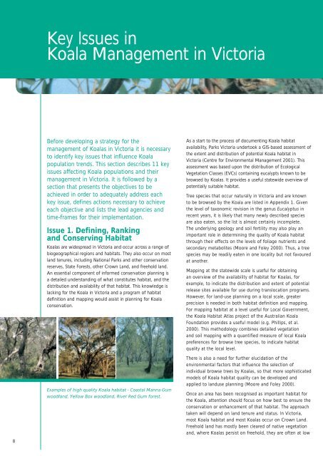
Key Issues in<strong>Koala</strong> <strong>Management</strong> in VictoriaBefore developing a strategy for themanagement <strong>of</strong> <strong>Koala</strong>s in Victoria it is necessaryto identify key issues that influence <strong>Koala</strong>population trends. This section describes 11 keyissues affecting <strong>Koala</strong> populations <strong>and</strong> theirmanagement in Victoria. It is followed by asection that presents the objectives to beachieved in order to adequately address eachkey issue, defines actions necessary to achieveeach objective <strong>and</strong> lists the lead agencies <strong>and</strong>time-frames for their implementation.Issue 1. Defining, Ranking<strong>and</strong> Conserving Habitat<strong>Koala</strong>s are widespread in Victoria <strong>and</strong> occur across a range <strong>of</strong>biogeographical regions <strong>and</strong> habitats. They also occur on mostl<strong>and</strong> tenures, including National Parks <strong>and</strong> other conservationreserves, State Forests, other Crown L<strong>and</strong>, <strong>and</strong> freehold l<strong>and</strong>.An essential component <strong>of</strong> informed conservation planning isa detailed underst<strong>and</strong>ing <strong>of</strong> what constitutes habitat, <strong>and</strong> thedistribution <strong>and</strong> availability <strong>of</strong> that habitat. This knowledge islacking for the <strong>Koala</strong> in Victoria <strong>and</strong> a program <strong>of</strong> habitatdefinition <strong>and</strong> mapping would assist in planning for <strong>Koala</strong>conservation.Examples <strong>of</strong> high quality <strong>Koala</strong> habitat - Coastal Manna Gumwoodl<strong>and</strong>, Yellow Box woodl<strong>and</strong>, River Red Gum forest.As a start to the process <strong>of</strong> documenting <strong>Koala</strong> habitatavailability, Parks Victoria undertook a GIS-based assessment <strong>of</strong>the extent <strong>and</strong> distribution <strong>of</strong> potential <strong>Koala</strong> habitat inVictoria (Centre for Environmental <strong>Management</strong> 2001). Thisassessment was based upon the distribution <strong>of</strong> EcologicalVegetation Classes (EVCs) containing eucalypts known to bebrowsed by <strong>Koala</strong>s. It provides a useful statewide overview <strong>of</strong>potentially suitable habitat.Tree species that occur naturally in Victoria <strong>and</strong> are knownto be browsed by the <strong>Koala</strong> are listed in Appendix 1. Giventhe level <strong>of</strong> taxonomic revision in the genus Eucalyptus inrecent years, it is likely that many newly described speciesare also eaten, so the list is almost certainly incomplete.The underlying geology <strong>and</strong> soil fertility may also play animportant role in determining the quality <strong>of</strong> <strong>Koala</strong> habitatthrough their effects on the levels <strong>of</strong> foliage nutrients <strong>and</strong>secondary metabolites (Moore <strong>and</strong> Foley 2000). Thus, a treespecies may be readily eaten in one locality but not favouredat another.Mapping at the statewide scale is useful for obtainingan overview <strong>of</strong> the availability <strong>of</strong> habitat for <strong>Koala</strong>s, forexample, to indicate the distribution <strong>and</strong> extent <strong>of</strong> potentialrelease sites available for use during translocation programs.However, for l<strong>and</strong>-use planning on a local scale, greaterprecision is needed in both habitat definition <strong>and</strong> mapping.For mapping habitat at a level useful for Local Government,the <strong>Koala</strong> Habitat Atlas project <strong>of</strong> the Australian <strong>Koala</strong>Foundation provides a useful model (e.g. Phillips, et al.2000). This methodology combines detailed vegetation<strong>and</strong> soil mapping with a quantified measure <strong>of</strong> local <strong>Koala</strong>preferences for browse tree species, to indicate habitatquality at the local level.There is also a need for further elucidation <strong>of</strong> theenvironmental factors that influence the selection <strong>of</strong>individual browse trees by <strong>Koala</strong>s, so that more sophisticatedmodels <strong>of</strong> <strong>Koala</strong> habitat quality can be developed <strong>and</strong>applied to l<strong>and</strong>use planning (Moore <strong>and</strong> Foley 2000).Once an area has been recognised as important habitat forthe <strong>Koala</strong>, attention should focus on how best to ensure theconservation or enhancement <strong>of</strong> that habitat. The approachtaken will depend on l<strong>and</strong> tenure <strong>and</strong> status. In Victoria,most <strong>Koala</strong> habitat <strong>and</strong> most <strong>Koala</strong>s occur on Crown L<strong>and</strong>.Freehold l<strong>and</strong> has mostly been cleared <strong>of</strong> native vegetation<strong>and</strong>, where <strong>Koala</strong>s persist on freehold, they are <strong>of</strong>ten at low8

![Recycling [ PDF, 62KB ] - University of Queensland](https://img.yumpu.com/51805185/1/184x260/recycling-pdf-62kb-university-of-queensland.jpg?quality=85)