prioritizing future development and growth - Stuckeman
prioritizing future development and growth - Stuckeman
prioritizing future development and growth - Stuckeman
- No tags were found...

Create successful ePaper yourself
Turn your PDF publications into a flip-book with our unique Google optimized e-Paper software.
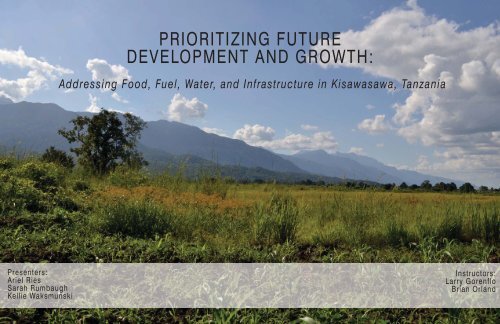
PRIORITIZING FUTUREDEVELOPMENT AND GROWTH:Addressing Food, Fuel, Water, <strong>and</strong> Infrastructure in Kisawasawa, TanzaniaPresenters:Ariel RiesSarah RumbaughKellie WaksmunskiInstructors:Larry GorenfloBrian Orl<strong>and</strong>
PRIORITIZING FUTUREDEVELOPMENT AND GROWTHTable of ContentsIntroductionSetting <strong>and</strong> ContextCurrent L<strong>and</strong> UseIssues & Project GoalsFood SecurityInventory & AnalysisDesign SolutionsFuel SecurityInventory & AnalysisDesign SolutionsWater SecurityInventory & AnalysisDesign SolutionsInfrastructureTransportationWaterElectricityFuture DevelopmentGrowth ProjectionsOverall PlanPriorities, Phasing, <strong>and</strong> Management SuggestionsProject ImplicationsReferences3456-78-1112-1314-1617-181920-2122-232627282930PRIORITIZING FUTURE DEVELOPMENT AND GROWTH:ADDRESSING FOOD, FUEL, WATER AND INFRASTRUCTURE IN KISAWASAWA, TANZANIA2
3INTRODUCTIONSetting <strong>and</strong> Context of Kisawasawa, TanzaniaKisawasawaSettingThe village of Kisawasawa is located in the Kisawasawa Ward, Mang’ula Division, <strong>and</strong> Kilombero District of theMorogoro Region of Tanzania (Harrison 2006b). In the 2002 Census, the village’s population was recorded as2,437 persons (Harrison 2006b). However, within the district, population is estimated to be increasing at a rate of3.4 percent a year, with the current population at 3,404 persons <strong>and</strong> growing each year (Harrison 2006b).Kisawasawa’s location, at the edge of the fertile Kilombero Valley <strong>and</strong> bordered to the west by the UMNP, has longallowed inhabitants to rely on the park’s natural resources for their livelihood (Harrison 2006b). Presently, l<strong>and</strong> tothe east of the village is used for subsistence <strong>and</strong> small scale commercial rice production. With increasingpopulation, the need to both exp<strong>and</strong> the village’s residential areas <strong>and</strong> exp<strong>and</strong> the village’s agricultural fields tothe east has been identified. With the limiting border of the National Park to the west <strong>and</strong> the seasonally wet <strong>and</strong>swampy fields to the east, <strong>future</strong> expansion will require careful <strong>and</strong> thoughtful planning. This planning will need toaddress food, fuel, <strong>and</strong> water securities for the growing village in a multitude of ways <strong>and</strong> for a variety of reasons.PRIORITIZING FUTURE DEVELOPMENT AND GROWTH:ADDRESSING FOOD, FUEL, WATER AND INFRASTRUCTURE IN KISAWASAWA, TANZANIA
INTRODUCTIONCurrent L<strong>and</strong> UseNorthLegendVillage BoundaryStreamTransportationRailroadOccupied PlotRice ProductionFood Production, non-riceUnoccupied Village L<strong>and</strong>0 1000MetersScale 1:10,000L<strong>and</strong> in KisawasawaKisawasawa is organized according to a north-south, east-west grid.Commercial <strong>and</strong> residential l<strong>and</strong> uses are centered around the maintarmac road <strong>and</strong> railroad <strong>and</strong> extend east. This occupied area issurrounded by a ring of small scale agricultural fields <strong>and</strong> privateshambas. This ring is surrounded by a ring of rice fields extending tothe east.These l<strong>and</strong> uses correspond with characteristics of the l<strong>and</strong>. Theeastern section of the village consists of low-lying, seasonally wet flatl<strong>and</strong>, while the western section at the base of the UdzungwaMountains is drier <strong>and</strong> more suitable for construction.L<strong>and</strong> use density within the village is low, <strong>and</strong> many plots of villagel<strong>and</strong> exist within the western section.Statistics69.7 ha179.4 ha61.0 ha48.7 haOccupied Plots& RoadsRice ProductionFood Production,non-riceUnoccupiedVillage L<strong>and</strong>358.8 ha Total AreaPRIORITIZING FUTURE DEVELOPMENT AND GROWTH:ADDRESSING FOOD, FUEL, WATER AND INFRASTRUCTURE IN KISAWASAWA, TANZANIA4
5INTRODUCTIONIssues <strong>and</strong> Project GoalsThe <strong>future</strong> expansion <strong>and</strong> <strong>development</strong> of Kisawasawa is certain; yet how this <strong>development</strong> will be approached is not asclear. For the expansion of Kisawasawa to be sustainable, security in food, fuel, <strong>and</strong> water each must be achieved. Thisproject will look at options <strong>and</strong> specific approaches for Kisawasawa to obtain security in each of these areas.Acknowledging that actual solutions will be a complex integration of food, fuel, <strong>and</strong> water securities, the project will thencombine these issues into a set of priorities <strong>and</strong> <strong>development</strong> models for the village. By strategically <strong>and</strong> spatiallycombining the approaches to obtaining these securities, this project will leave Kisawasawa’s Village Council with a guideto help them achieve cohesive <strong>and</strong> coherent expansion, while enhancing sustainable resource consumption, appropriatel<strong>and</strong> use, <strong>and</strong> quality of life. Ultimately, it will be a way to help Kisawasawa maintain its vibrant community into the <strong>future</strong>.These three securities do not exist in isolation. Food is impacted by fuel which is impacted by water, while water is impacted byfuel which is impacted by food. Infrastructure, in particular access to transportation, electricity, <strong>and</strong> water sources, is affected bythe quantity <strong>and</strong> quality of these necessities. It is impossible to approach any of these issues without addressing the others. InKisawasawa’s agriculturally dominated society, food production directly corresponds with the availability or lack of water(Harrison 2006b). Additionally, with the current absence of electricity, other types of fuel are required to cook food. Fuelproduction is often dictated by water levels. And water quality is impacted by food <strong>and</strong> fuel production <strong>and</strong> consumption. Theconnections are seemingly infinite. Additionally, the issues of human health <strong>and</strong> well being are also tightly connected to thistriage of food, fuel, <strong>and</strong> water. The individual issues are interwoven into a complex network that influences every aspect of thevillage’s community, from its members, to its form, to its quality of life.This project will entail two phases. The first involves addressing the issues of food, fuel, <strong>and</strong> water securities individually.The second phase involves combining these findings into an integrated model <strong>and</strong> a set of priorities that can guide <strong>future</strong><strong>development</strong> <strong>and</strong> expansion in Kisawasawa. The first phase will be undertaken by individual group members each with aparticular focus. However, communication between members will be high, <strong>and</strong> all will contribute towards each issue.Ultimately, each focus will result in specific design solutions for direct implementation <strong>and</strong> possible connections <strong>and</strong>concepts to carry into phase two. The second phase will involve a synthesis of the former phase. In this way, the findingsof each issue will be combined into a spatial <strong>and</strong> strategic model for the village of Kisawasawa. Spatially, <strong>development</strong>recommendations will be made based on the most efficient ways to increase food, fuel, <strong>and</strong> water efficiencies.Strategically, priority areas <strong>and</strong> projects will be identified. The result, in essence a master plan to guide the <strong>growth</strong> ofKisawasawa, will in fact not be a planning document but an approach for the village to start thinking about theirexpansion. In this way, we will not create a formal plan for Kisawasawa, but a way for the residents of Kisawasawa tocreate their own plan for the <strong>future</strong> of their village.PRIORITIZING FUTURE DEVELOPMENT AND GROWTH:ADDRESSING FOOD, FUEL, WATER AND INFRASTRUCTURE IN KISAWASAWA, TANZANIA
6FOOD SECURITYInventory & AnalysisFood Security is...Natural Population+ Attractive L<strong>and</strong>In 10 Years... Population== 3.4% Annual Population55.47%55.47% Population + 55.47% Food Production = Available L<strong>and</strong>Current Rice FieldsConversion of Rice Fieldsregular access to sufficient foods for a healthy <strong>and</strong> productive lifea multidisciplinary process that involves the application of science to produce, preserve <strong>and</strong> store foodapplying strategic planning to achieve productions <strong>and</strong> distribution of productsIssues in Kilombero DistrictPossible Design SolutionsFood Production FieldsUnder used L<strong>and</strong> Food dProduction Food od Security+ = =PRIORITIZING FUTURE DEVELOPMENT AND GROWTH:ADDRESSING FOOD, FUEL, WATER AND INFRASTRUCTURE IN KISAWASAWA, TANZANIA
FOOD SECURITYInventory & Analysis - Current Food ProductionKisawasawa Crop ProductionThe extent of the agricultural fields in Kisawasawa consist of the production of rice whichextend into the east. For food security to succeed in the village in the <strong>future</strong>, an increase infood production needs to be concurrent with the population increase. The amount of l<strong>and</strong>used for cash crop growing, such as rice, needs to be converted into food production for thevillage in order to achieve food security for the estimated population <strong>growth</strong>.Food EfficiencyThe combination of both the population increase <strong>and</strong> the lack of available l<strong>and</strong> urges anincrease food efficiency. To produce a sufficient amount of food with a possible surplusrequires a more effective way to farm on the same or only slightly more l<strong>and</strong>. The underutilized l<strong>and</strong> in the village center allows for production to increase through infill instead ofresorting to eastern agricultural sprawl.Food Storage & MarketingStoring <strong>and</strong> marketing food production allows for a more successful food security. InKisawasawa, there is no definite market place to sell surplus crops. Initiating commercialdistricts along main roads improves the cash inflow for the village. Storing crops also helpseliminate the corruption in selling crops at low prices. Simple storage facilities can helpalleviate the issues of weather <strong>and</strong> animal degradation.PRIORITIZING FUTURE DEVELOPMENT AND GROWTH:ADDRESSING FOOD, FUEL, WATER AND INFRASTRUCTURE IN KISAWASAWA, TANZANIA7
FOOD SECURITYInventory & Analysis - Current Food ProductionCurrent Food Production in KisawasawaThe present l<strong>and</strong> use for agriculture is dominated by rice production. The rice fields arealso close to the village center, which will become a commodity when populationincreases. Since the available l<strong>and</strong> will always be decreasing, the pressure for l<strong>and</strong> to beused for food production instead of for cash crops will increase.LegendRice FieldFood ProductionBuildingRoad/PathRailroadStreamRice ProductionFood ProductionTotal Crop Production179.4 ha48.7 ha228.1 haScenario 1: Complete ConversionPopulation:Food + Efficiency + AvailableL<strong>and</strong> =ProductionScenario 1 illustrates how Kisawasawa will look in 10 years when the population increases by 55.47%<strong>and</strong> does not increase their efficiency in food production. If the population increases by a certainamount, that means the food production will need to also increase by that certain amount, whether inadditional l<strong>and</strong> used or increased in efficient production with the current amount of l<strong>and</strong>. This scenarioshows that if Kisawasawa does not increase their efficiency in food production but the populationincreases, then the amount of rice fields needed to fill the void left by the ill-efficient production willcause a 100% conversion of their rice fields to food production to make up for the increased populationScenario 2: Partial ConversionPopulation : Food + Efficiency+ AvailableL<strong>and</strong>=Production100%Rice FieldConversion50%Rice FieldConversionScenario 2 illustrates how Kisawasawa will look in 10 years when the population increases by 55.47%<strong>and</strong> does increase their efficiency in food production. If the village can increase the efficiency by half,then the food production that needs extra l<strong>and</strong> will also be only half. This results in the conversion of therice fields near the village center to only be 50%, which allows for the farmers to still access their cashcrop <strong>and</strong> food with ease. This scenario brings about an issue as to how toPRIORITIZING FUTURE DEVELOPMENT AND GROWTH:ADDRESSING FOOD, FUEL, WATER AND INFRASTRUCTURE IN KISAWASAWA, TANZANIA0 250 500 750 1000 MetersNorth8
FOOD SECURITYDesign Solutions - Minimizing L<strong>and</strong> Use PressureUtilizing Unused L<strong>and</strong> within the VillageUnder utilized l<strong>and</strong> in the village has caused exploitation of l<strong>and</strong> further out for cropproduction, causing the availability of l<strong>and</strong> for agriculture to decrease. The spacing ofhouses <strong>and</strong> their relative builidings through large dirt plazas <strong>and</strong> overgrown vegetationcreates an opportunity for small scale farming in the under utilized spaces. Foundations thathave been overgrown also prove to be a viable option for l<strong>and</strong> utilized for crop production.This small scale solution for increasing efficiency in food production can allow for multiplecrops to grow in the open roof foundations. Kisawasawa has many ab<strong>and</strong>oned foundationsthat can be used by either one family or multiple families in the surrounding area.Foundation - Plan ViewSuggested Crops:Banana TreesFoundation - Section ViewRice Nursery Maize CassavaLocation of Foundations in KisawasawaThe amount of foundations in Kisawasawa shows the potential for thel<strong>and</strong> use to be turned into both rice nurseries <strong>and</strong> crop gardens.Though the amount of l<strong>and</strong> is small, the foundations provide adequatesunlight as well as a close proximity to the house for security.LegendFoundationBuildingRoad/PathRailroadStreamPRIORITIZING FUTURE DEVELOPMENT AND GROWTH:ADDRESSING FOOD, FUEL, WATER AND INFRASTRUCTURE IN KISAWASAWA, TANZANIANorth0 250 500 750 1000Meters9
10FOOD SECURITYDesign Solutions - Storage & MarketingStorageThe storing of crops currently in Kisawasawa is an issue that cangreatly improve food security. If surplus cash crops are stored as wellas food production, the farmer can sell the product at a higher pricewhen the dem<strong>and</strong> is high. Storage from weather <strong>and</strong> animaldegradation for the purpose of selling can facilitate a market district.Communal or Individual Storage FacilityThe design for the storage facility can function as both acommunity facility <strong>and</strong> an individual family’s facility. Themulti-roomed facility allows for 5 people to either rent a room,or 5 rooms to be used for the farmer’s crops. The structureallows for damage from weather ad animals to be minimal.Location Options for Facility:Adjacent to FieldsAdjacent to House/ ShambaCommunity MarketReasons for Community Storage:High level of securityLocated on community l<strong>and</strong>Multi-family storage capabilityReasons for Individual Storage:Less chance of stolen goodsLarger area for food storageLocated on private l<strong>and</strong>Items for Storage:Cash Crops (bagged rice)Rice HusksFood (cassava, maize, beans)FuelwoodFarming ToolsMarketingTo increase food security, the production of a surplus of crops isnecessary. Kisawasawa currently has no distinct market for the saleof cash crops. Marketing the enormous rice production in thevillage would help bring in extra income for the farmers, which inturn can help them buy ways to increase efficiency in farming.Storage RoomStorage RoomStorage RoomCommunalStorage RoomStorage RoomStorage RoomPRIORITIZING FUTURE DEVELOPMENT AND GROWTH:ADDRESSING FOOD, FUEL, WATER AND INFRASTRUCTURE IN KISAWASAWA, TANZANIA
11FOOD SECURITYDesign Solutions - Crop Production & WoodlotsInitiating Woodlots through Crop ProductionThe use of woodlots in Kisawasawa will be necessary in the <strong>future</strong> for fuel. The initial set-up ofthe lots may seem like a wasted space to many in the village since the trees will be too young tocultivate, <strong>and</strong> so a combinated of crop production <strong>and</strong> woodlots can be used. To maximize l<strong>and</strong>efficiency for both the woodlot <strong>and</strong> food production, the combination can benefit the farmer <strong>and</strong>the community through the duel uses.Combining both crop production <strong>and</strong> woodlot design allows for root vegetables to be grownbetween the spaced trees. The canopy will never be full <strong>and</strong> closed since the villagers will becutting <strong>and</strong> utilizing the woodlot for fuel. NGO’s such as WWF or government programs such asTANAPA can be options for assistance <strong>and</strong> funding for the set-up of the combined woodlots.Section View of Crop Production& WoodlotThe 10m spacing between thetrees allows for ample light toreach the cropsPlan View of Crop Production& Woodlot10m10mPRIORITIZING FUTURE DEVELOPMENT AND GROWTH:ADDRESSING FOOD, FUEL, WATER AND INFRASTRUCTURE IN KISAWASAWA, TANZANIA
Woodlot outside of the village of MwayaHome located next to rice fieldsTree nursery at a local primary school - thenursery must be fenced in <strong>and</strong> shadedMan cooking with a rice husk stoveFUEL SECURITYInventory & AnalysisFuel Shortage73% of households in the villages surrounding the Udzungwa MountainsNational Park depend on fuelwood for cooking <strong>and</strong> heating.About 66% of this wood is collected from the National Park (Nyundo etal. 2006). Starting 30 June 2011 people will be forced to find alternativefuel sources as they will no longer be able to access fuelwood from thePark (Nyundo et al. 2006).Rice Husks as an AlternativeFuel SourceRice husks are the outer shell of the paddy grain. The husks form about20% of the weight of the paddy. Before husking the paddies are dried tohave a 14% moisture content. This drying process is important to ensurethat the husks can be used effectively as fuel, since husks with a highmoisture content do not burn easily. During the milling process the husk isseparated from the grain in a husker. These huskers produce either wholeor ground husks, with whole husks being preferable for burning in ricehusk stoves.Rice husks are usually discarded in large piles or they are burned, as theyare regarded as a waste material in most circumstances (Belonio 2005).However, the dominance of rice agriculture in Kisawasawa ensures that ifrice husk stoves were available to households <strong>and</strong> people were educatedon how to use them effectively, rice husks could prove to be a viableenergy alternative to fuelwood.Ecological Benefits ofRice Husks as FuelBy using rice husks forfuel instead of deadwoodthe existing forestis preserved as lesstrees are cut down <strong>and</strong>deadwood is allowed todecay naturally, contributingto the valuablesoil organic matter(Belonio 2005).Inner DrumSupport legsPot Holder BracketExample of a rice husk cooker(Adapted from LoTrau Stove)Outer DrumMain DrumAsh Holder &Basket20% 500 73.5Percent massof rice paddythat is therice huskApproximatenumber ofhouseholds inKisawasawaHousehold InformationKisawasawa’s population: 2,437 peopleAverage household size: 5 people2,437 / 5 = Approximate number of householdsApproximate number of households: 487.4 householdsRice Husks for FuelRice Husks per HectareBags of riceproduced perhectare pergrowing seasonTotal hectares of rice fields in Kisawasawa: 121.125 haBags of rice produced per hectare per growing season: 73.5 bagsEach bag of rice is 100 kgMass of rice husks: 20% the mass of a bag (20 kg)Bags of rice produced per hectare per growing season: 73.5 bagsEach bag of rice is 100 kg73.5 bags x 100 kg = kg of rice per hectareKg of rice per hectare = 7,350 kgMass of rice husks: 20% the mass of a bag (20 kg)7,350kg of rice x 0.20 = kg rice husks per hectareKg rice husks per hectare = 1,470 kgTotal hectares of rice fields in Kisawasawa: 121.125 ha1,470 kg of rice husks x 121.125 ha = Amount of rice husksAmount of rice husks from Kisawasawa’s rice fields per year: 178,053.8PRIORITIZING FUTURE DEVELOPMENT AND GROWTH:ADDRESSING FOOD, FUEL, WATER, AND INFRASTRUCTURE IN KISAWASAWA, TANZANIA12
Saplings growing at school nurseryWood collected from the National Park on aThursday - the day residents are permitted tocollect deadwood from the forestHomes are located directly adjacent to theNational ParkKisawasawa has an abundance of vegetation<strong>and</strong> canopy coverage within the villageFUEL SECURITYInventory & AnalysisDependence on Deadwoodfor FuelIn the Kilombero Valley the average household of five people consumesone to two bundles of firewood per week for domestic use (Harrison2006b). A bundle of firewood sells for about TSh. 600 (Harrison2006b). If people resorted to buying the firewood, which currently theyare collecting for free, this would impose a cost of between TSh. 30,000<strong>and</strong> TSh. 60,000 on households annually - making this source ofenergy cost prohibitive for most families. While rice husks can provideabout one month’s worth of fuel for residents of Kisawasawa, the fuelefficient woods stoves are the best possibility for drastically decreasingKisawasawa’s energy dem<strong>and</strong>s.Woodlots must be established in Kisawasawa in order to provide fuelwoodfor residents after the closure of Udzungwa Mountaions NationalPark’s borders for deadwood collection on 30 June 2011. Saplings forthe woodlots should be grown in nurseries run by the schools <strong>and</strong> othercommunity groups in order to produce healthy trees in the woodlotsDeadwood for FuelTrees needed per year per household: 20-medium sizedtrees (6 m high)Wood used per household annually with inefficient woodstoves: 3486.6 kgTrees needed per year per household with fuel efficient stove:8.8 treesTrees produced per hectare of woodlot: 400 treesApproximate number of households: 487.4 householdsWood (kg) x 1.18 = Rice husk energy equivalent (kg)Annual Deadwood Consumption for KisawasawaTrees needed per year per household: 20-medium sized trees (6m high)20 trees x 487.4 households = Trees needed for Kisawasawa annuallyTrees needed for Kisawasawa annually: 9,748 medium sized treesTrees produced per hectare of woodlot: 400 trees9,748 trees / 400 trees = Hectares of woodlot needed annuallyHectares of woodlot needed annually for Kisawasawa = 24.37 hectares20Trees needed peryear per householdwith inefficientstoves8.8 8.9%Trees neededper year withefficient woodstovesAnnual Deadwood Consumption for Kisawasawawith Energy Efficient Wood StovesTrees needed per year per household with fuel efficient stove: 8.8 trees8.8 trees x 487.4 households = Trees needed for Kisawasawa annuallyTrees needed for Kisawasawa annually with fuel efficient stove: 4,289.12 treesTrees produced per hectare of woodlot: 400 trees4,289.12 trees / 400 trees = Hectares of woodlot needed annuallyHectares of woodlot needed annually for Kisawasawa = 10.72 hectaresRice Husk Contribution to Fuel NeedsPercent of fuelneeds that couldbe met with ricehusksWood utilized per household per year: 3,486.6 kg3,486.6 kg x 487.4 households = Wood utilized by Kisawasawa annuallyWood utilized annually by Kisawasawa: 1,699,368.84 kgWood (kg) x 1.18 = Rice husk energy equivalent (kg)1,699,368.84kg x 1.18 = Rice husk energy equivalentEquivalent energy in rice husks: 2,005,255 kgAmount of rice husks from Kisawasawa’s rice fields per year: 178,053.8178,053kg / 2,005,255 kg = percent of Kisawasawa’s fuel needs met byrice husksPercent of Kisawasawa’s fuel needs met by rice husks: 8.9%2,005,255kg - 178,053kg = Difference between fuel needed <strong>and</strong> fuelavailable in rice husksDifference between fuel needed <strong>and</strong> fuel available: 1,827,201 kg rice husksWood (kg) x 1.18 = Rice husk energy equivalent (kg)1,827,201 kg / 1.18 = Wood energy equivalentEquivalent energy in wood= 1,548,475.8 kgWood utilized annually by Kisawasawa: 1,699,368.84 kg1,699,368.84 kg - 1,548,475.8 kg = Energy obtained by rice husksHectares of woodlot needed annually for Kisawasawa = 24.37 hectaresPercent of Kisawasawa’s fuel needs met by rice husks: 8.9%24.37 - (24.37 ha x .089) = Hectares of woodlot needed if with rice huskstoves are utilizedHectares of woodlot needed if with rice husk stoves are utilized: 22.2 haPRIORITIZING FUTURE DEVELOPMENT AND GROWTH:ADDRESSING FOOD, FUEL, WATER, AND INFRASTRUCTURE IN KISAWASAWA, TANZANIA13
FUEL SECURITYDesign SolutionsL<strong>and</strong> Use Development Model:WoodlotsWoodlots will be located in many areas around Kisawasawato increase resilience. If pests, animals, orpoachers negatively impact one woodlot, the communitywill not lose all of its trees. This will also be helpfulin determining which areas of village l<strong>and</strong> are mostproductive <strong>and</strong> most secure.1234Woodlots will be established as a bufferbetween the National Park <strong>and</strong> the village.These lots will decrease the edge effects of theforest, <strong>and</strong> trees here will thrive in soil that issuitable for their <strong>growth</strong>.Woodlots will be planted in areas of thevillage with important significance to villagers,especially near institutions such aschurches, mosques, schools, <strong>and</strong> medicalcenters in hopes that these institutions willserve as guards against people attempting tosteal from the woodlots.Woodlots will be planted in areas near existing homes, where spacepermits, as villagers will help to police this asset to their community. Theselots may or may not be for the residents surrounding the lots.These large continuous woodlots are designated as the major fuel source for thevillage. These contiguous plots also provide habitat for birds <strong>and</strong> small mammals.Because of the size <strong>and</strong> juxtaposition to the village boundary, these woodlots aremore vulnerable, therefore these lots will need to be protected by a hired guard.12100 hectares 400 trees per hectare 40,000 trees3North4woodlot65existingresidential5rice fields0 1000MetersScale 1:10,000roads6foodcropsAs residential <strong>development</strong> occurs eastward,woodlots will be incorporated into the villageexpansion. The woodlots will be surroundedby homes, similar to the woodlots establishedwithin the village center, so trees can be protectedby the villagers surrounding them.Access road throughthe woodlot usedprimarily for maintenancepurposes <strong>and</strong>for planting <strong>and</strong>harvesting treesPRIORITIZING FUTURE DEVELOPMENT AND GROWTH:ADDRESSING FOOD, FUEL, WATER, AND INFRASTRUCTURE IN KISAWASAWA, TANZANIA14
17WATER SECURITYInventory & AnalysisImportance of WaterWater impacts all forms of life (Mittermeier et al. 2010). It forms the foundation for nearlyevery human activity <strong>and</strong> all rely on it (Mittermeier et al. 2010). It impacts human health,livelihood, <strong>and</strong> wellbeing. It is used in food preparation, construction, <strong>and</strong> industry.Ensuring water security should be a primary goal of any group or locality. The mainfactors involved in obtaining water security are: access to water, water quality, rate ofconsumption, <strong>and</strong> flooding <strong>and</strong> st<strong>and</strong>ing water.Water in KisawasawaThe combination of two rainy seasons, numerous mountain springs, <strong>and</strong> abundantgroundwater provide Kisawasawa with plentiful amounts of water for much of the year.Villagers typically have access to water in the form of streams, st<strong>and</strong> pipes, <strong>and</strong> waterpumps (Harrison 2006b). Water quality appears to be high, however potentialcontaminants from roads <strong>and</strong> latrines may be polluting ground <strong>and</strong> surface water.Consumption rates have currently not exceeded dem<strong>and</strong>, but changes in precipitationor increased abstraction from groundwater could change that. Flooding is a concernin the relatively flat village, where depressions also store st<strong>and</strong>ing water, creatingbreeding grounds for mosquitoes <strong>and</strong> other insects.RecommendationsAccessAdditional water abstraction sites, in the form of st<strong>and</strong> pipes or water pumps, shouldbe constructed to ensure equal access to water for all.ConsumptionSustainable consumption should be encouraged. While water is an abundant resourcenow, care should be taken to use minimal water to ensure its abundance in the <strong>future</strong>.QualityWater quality should be monitored. Care should be taken to locate sources ofcontamination <strong>and</strong> pollution away from water sources <strong>and</strong> abstraction points.Stormwater ManagementTo prevent flooding, measures should be taken to slope l<strong>and</strong> away from structures <strong>and</strong>into a network that safely takes water to streams. Similarly, care should be taken to notdirect water into dead end locations, causing stagnation.ImplicationsKisawasawa’s successful <strong>future</strong> <strong>development</strong> <strong>and</strong> <strong>growth</strong> will require aheightened water security, both within the western developed portion <strong>and</strong> fornew <strong>development</strong> in the east. Water security will directly impact food <strong>and</strong> fuelsecurity, <strong>and</strong> also have impacts on transportation infrastructure <strong>and</strong> road quality.PRIORITIZING FUTURE DEVELOPMENT AND GROWTH:ADDRESSING FOOD, FUEL, WATER AND INFRASTRUCTURE IN KISAWASAWA, TANZANIA
WATER SECURITYInventory & AnalysisWater QualityTwo of the main impacts on water quality in Kisawasawa are the proximity of roads tostreams <strong>and</strong> the proximity of pit latrines to water abstraction points. Both can causepollutants <strong>and</strong> contaminants to enter the water source (WHO 1992).ImplicationsRoad <strong>and</strong> Stream ProximityErosion from roads can lead to sediment <strong>and</strong>pollution entering nearby streams. Distancesbetween streams <strong>and</strong> roads should be maximized.14Road or Trail &StreamConflictsLegendMajor StreamExisting Road or TrailExisting StructureRoad or Trail within 15mof StreamSeveral existing roads could be negatively impacting water quality. Vegetated buffers<strong>and</strong> sloping l<strong>and</strong> away from streams can minimize these impacts (PSU 2006). Newroad construction should maintain a 15m distance from streams.ImplicationsLatrines <strong>and</strong> Water AbstractionLeaching of pollutants from latrines can contaminatewater sources <strong>and</strong> water abstraction points such aswells, st<strong>and</strong> pipes, <strong>and</strong> streams (WHO 1992).Maintaining a distance of 15m between latrines <strong>and</strong>these abstraction points is suggested (WHO 1992).LegendMajor StreamOther Water SourceExisting LatrineExisting Structure, non-latrineExisting Latrine within 15mof Water SourceLatrine distribution varies widely within Kisawasawa. Approximately 23 latrinescurrently are within 15m of water abstraction points. Additional undocumentedlatrines may also pose a risk. Future latrine construction should be confined to areasfurther than 15m from abstraction points. The gradual implementation of septic tanksis also suggested to replace pit latrines. Septic tanks cause less contamination thanpit latrines (WHO 1992).North0 1000MetersScale 1:10,00023Latrines within15m of a WaterSourcePRIORITIZING FUTURE DEVELOPMENT AND GROWTH:ADDRESSING FOOD, FUEL, WATER AND INFRASTRUCTURE IN KISAWASAWA, TANZANIA18
WATER SECURITYDesign SolutionsStormwater ManagementStormwater Management, safely <strong>and</strong> efficiently managing rainfall, is one of the primarysolutions to ensuring water security. It has implications for water quality, flooding, velocity,<strong>and</strong> pooling.Maintain Vegetated CoverVegetation, such as trees <strong>and</strong> shrubs,absorbs water <strong>and</strong> slows its speed,helping to prevent flooding <strong>and</strong> erosion.Buffer StreamsStreams are a source of freshwater for all.By maintaining a vegetated, unused bufferstrip of around 15m on either side of astream, pollutants <strong>and</strong> sediments can beprevented from entering the water supply.Prevent St<strong>and</strong>ing WaterSt<strong>and</strong>ing water is a breeding ground formosquitoes, other insects, <strong>and</strong> bacteriathat can cause illness or disease.St<strong>and</strong>ing water should be preventedwithin the village. Brick pits such as thiscan be filled or planted with vegetation.Direct Water Awayfrom StructuresThe ground outside of structuresshould slope away from the structureto ensure water does not enter. Thegrade should be steep enough toallow positive drainage but levelenough to prevent erosion.Divert Water for ReuseWater directed away from structuresor transportation networks can bechanneled into agricultural fields,nurseries, or tree lots to use asirrigation water.Water that falls on building roofs falls to the ground,then is directed away off-site or towards shambas.PRIORITIZING FUTURE DEVELOPMENT AND GROWTH:ADDRESSING FOOD, FUEL, WATER AND INFRASTRUCTURE IN KISAWASAWA, TANZANIA19
INFRASTRUCTURETransportation: Inventory & AnalysisTransportation <strong>and</strong> Right of WaysDefining <strong>and</strong> establishing a transportation infrastructure is one of the first steps in <strong>development</strong> <strong>and</strong> expansion. To allow for thisexpansion, Tanzanian Planning Guidelines suggest a 60m Right of Way (ROW) for a Trunk Road, 30m for a Primary Distributor, <strong>and</strong> 10mfor a Pedestrian access (Tanzanian Planning Commission 1997). If enforced, these ROWs will prevent <strong>development</strong> within them <strong>and</strong>require existing structures to be displaced.NorthDABC372Structures inRight ofWays0 1000MetersScale 1:10,00056Businessesin Right ofWays21.5%of Homeswithin Rightof WaysTransportation in KisawasawaKisawasawa’s transportation network consists of atrunk road running north to south, two primarydistributors running east to west, <strong>and</strong> numerouspedestrian ways <strong>and</strong> footpaths based on this griddedorganization.Legend880PotentialPersonsDisplacedTrunk RoadPrimary DistributorPedestrian AccessFootpathRoad Right of WayStructure in Right of WayOther StructureImplications of Right of WaysCurrently, 372 of Kisawasawa’s structures lie inexisting ROWs. Of these structures, 176 are housesmeaning21.5% of the homes in Kisawasawa couldbe displaced. Structures in Right of Ways may beable to move further from the road on their own plot,or may have to relocate to another plot.AConnecting Mikumi <strong>and</strong> Ifakara, the main road of Kisawasawa islined with shops, businesses, <strong>and</strong> homes.BOne of two primary distributors that run east-west through the villageis flanked by a small commercial district.CPedestrian trails are generally wider <strong>and</strong> more defined thanfootpaths. They often are very close to structures.DAn X on a building can signify that it was built within the road Rightof Way <strong>and</strong> is against the law.PRIORITIZING FUTURE DEVELOPMENT AND GROWTH:ADDRESSING FOOD, FUEL, WATER AND INFRASTRUCTURE IN KISAWASAWA, TANZANIA20
INFRASTRUCTURETransportation: Design SolutionsRoad Improvements <strong>and</strong> Establishing New RoadsKisawasawa’s gridded organization already has a hierarchy of roads <strong>and</strong> trails. The main roads serve as an excellent foundation to beginroad improvements. If funds become available, any of these 5 roads could be improved through resurfacing <strong>and</strong> drainage. Theseimprovements will be important for use by the growing population in the <strong>future</strong>. With <strong>future</strong> <strong>development</strong>, establishing new roads can laythe organization for the <strong>growth</strong>. The suggested roads follow the existing organization of the village, <strong>and</strong> can be modified <strong>and</strong> moved tosuit the needs.North0 1000MetersScale 1:10,000SummaryIf enforced, road Right of Ways will have the most impact aroundexisting roads. Proposed new roads should be placed to avoidconflicts with existing structures. Road improvements should bethe first priority in improving transportation infrastructure. Subtleimprovements can help foster the village’s <strong>development</strong> <strong>and</strong>progress into the <strong>future</strong>.11Structures inProposedRight of WayLegend5RoadsPrioritized forImprovementExisting RoadProposed Road ImprovementsExisting Road Right of WayStructure in Right of WayProposed Road Right of WayStructure in Proposed Right of WayOther StructureRoad Improvement Suggestion:Raising the RoadBefore: An entrenched road traps road drainage onthe road in parallel ditches. This is a situation thatrequires constant maintenance. Raising the roadeliminates the persistent maintenance associated witha road that is lower than the surrounding terrain.ditchflowCross-section #1During: Prep the existing road base with proper crownbefore adding fill material. Place fill material in the roadprofile in 8” to 12” lifts. Each lift of material should beplaced with proper crown of ½” to ¾” per foot.Compact each lift of material to ensure a solid roadbase. Geo-textile fabric can be used in between lifts ofmaterial to add strength to the road base. Wheneverpossible, add enough fill material to raise the elevationof the road to restore natural drainage patterns.After: Place aggregate on the fill material. Becausethe fill has been crowned or shaped properly, theaggregate will retain its shape <strong>and</strong> facilitate sheet flowoff the road.sheetflowCross-section #41 st lift of fillCross-section #2: The existing road base is re-shapedwith proper crown. The first lift of fill material is placed,crowned <strong>and</strong> compacted.2 nd lift of fill1 st lift of fillCross-section #3: The second lift of fill material is laidon top of the first lift, crowned <strong>and</strong> compacted.Diagram from PSU (2006)*Design solutions are based on the l<strong>and</strong> use recommendations outlined in theFuture Development Section of this document.PRIORITIZING FUTURE DEVELOPMENT AND GROWTH:ADDRESSING FOOD, FUEL, WATER AND INFRASTRUCTURE IN KISAWASAWA, TANZANIA21
INFRASTRUCTUREWater: Inventory & AnalysisWater AccessAccess to water is one of the primary components of a water infrastructure. In this region of Tanzania, water is plentiful during muchof the year (Nyundo 2006). Residents get water from both natural <strong>and</strong> man modified sources (Harrison 2006b). The availability ofwater within a reasonable proximity can directly impact <strong>development</strong>.NorthCA0 1000MetersScale 1:10,000BDWater Access in KisawasawaThe residents of Kisawasawa primarily get their water fromstreams, st<strong>and</strong> pipes, <strong>and</strong> water pumps. Only 9.5% ofhouseholds are within 20m of a water source. 31.9% arewithin 50m, while 61.9% are within 100m. This leaves 38.1%of homes further than 100m from a source of water.ImplicationsWithout access to water, villagers will suffer from a lack ofdrinking water, water for cooking, <strong>and</strong> water for householduse. Additional water sources should be constructed withinthe village. Also, new <strong>development</strong> to the east will requireadditional pipes <strong>and</strong> pumps. These can be constructedbefore <strong>development</strong>.Legend38.1%of Homes >100mfrom WaterSourceExisting Road or TrailMajor StreamOther Water Source
INFRASTRUCTUREWater: Design SolutionsConstructing New Water Access PointsSince water quantity is not a primary issue in Kisawasawa, access to their water supplies is then a primary issue for infrastructure. Awater infrastructure including new access points in the form of st<strong>and</strong> pipes <strong>and</strong> wells is suggested. Toward <strong>future</strong> <strong>development</strong>,water can be transported underground through pipes.NorthCA0 1000MetersScale 1:10,000B!D!SummaryThere are several areas in Kisawasawa that lack access to a closewater source. The addition of wells or new st<strong>and</strong> pipes can solvethis issue. In the <strong>future</strong>, a <strong>development</strong> goal should be to establishan underground piped water network.LegendExisting Road or TrailMajor StreamOther Water SourceProposed Water Source
INFRASTRUCTUREElectricity: Inventory & AnalysisElectric AccessAccess to electricity varies widely within Tanzania <strong>and</strong> the region (Harrison 2006b). Though not widely available presently, it presentsopportunities as an alternative fuel <strong>and</strong> energy source in the <strong>future</strong>.NorthDBCA0 1000MetersScale 1:10,000Electric Access in KisawasawaExisting electric lines in Kisawasawa could potentiallyprovide 12.8% of the village’s structures, those within30m of the lines, with electricity. However, the actualpercentage of structures with electric hookups is muchlower.LegendExisting Road or TrailMajor StreamExisting Electric LineExisting StructureExisting Structure within30m of Electric Line12.8%of Structureswith ElectricAccess93Houseswithin 30m ofElectric LineImplicationsExtending additional electric lines in Kisawasawa isone option to meet its energy dem<strong>and</strong>s. Though notfeasible on a large scale presently, with <strong>future</strong><strong>development</strong> <strong>and</strong> <strong>growth</strong> Kisawasawa couldimplement an electric infrastructure to grow upon.AElectric lines run along the east side of Kisawasawa’s main road, theprimary connector between Mikumi <strong>and</strong> Ifakara.BHousehold electric use in Kisawasawa is limited, however there areseveral home with electric hookups.CElectric poles are within road right-of-ways but l<strong>and</strong> below them isstill traditionally used for agriculture <strong>and</strong> other uses.DOne secondary line extends west from the main road, to the church<strong>and</strong> school complex.PRIORITIZING FUTURE DEVELOPMENT AND GROWTH:ADDRESSING FOOD, FUEL, WATER AND INFRASTRUCTURE IN KISAWASAWA, TANZANIA24
INFRASTRUCTUREElectricity: Design SolutionsConstructing New Power LinesThough a very large investment, constructing new power lines in Kisawasawa would bring access to electricity to anadditional 352 structures. And this is just those able to connect to the main line without additional support poles. Thisinfrastructure forms a ring through the village, <strong>and</strong> its central location would make it easy <strong>and</strong> less expensive for additionalareas of the village to branch off <strong>and</strong> gain electric access.LegendExisting Road or TrailMajor StreamExisting Electric LineExisting StructureExisting Structure within30m of Electric LineProposed Electric LineExisting Structure within 30mof Proposed Electric Line*Design solutions are based on the l<strong>and</strong> use recommendations outlined in theFuture Development Section of this document.352ExistingStructureswould gainAccess32.5%of Structureswith ElectricAccess+154%ElectricAccessibilitySummaryFacilitation for the FutureOnce the infrastructure is constructed, residents furtherthan 30m from the line could b<strong>and</strong> together to bringanother power line to their homes. The green line shownabove would only require 3 additional poles from the mainline <strong>and</strong> would allow 27 structures to have access toelectricity.If funds become available, establishing an electrical line infrastructure would be a greatbenefit to residents <strong>and</strong> the village as a whole.As the village develops, this infrastructure will help ensure its success.Creating this infrastructure along a central loop following primary roads would ensureimmediate access to the greatest number of people <strong>and</strong> ease the process of othersacquiring access.NorthPotential Branch Electric LineExisting Structure within 30m of Potential Branch0 1000MetersScale 1:10,000PRIORITIZING FUTURE DEVELOPMENT AND GROWTH:ADDRESSING FOOD, FUEL, WATER AND INFRASTRUCTURE IN KISAWASAWA, TANZANIA25
FUTURE DEVELOPMENTGrowth ProjectionsPopulation IncreasePopulation in the Kilombero District is predicted to increase at a rate of 3.4% a year(Harrison 2006b). With Kisawasawa’s population at the 2002 Census at 2437persons, population will double by 2021 (Harrison 2006b). Infill, expansion, or acombination of the two will be necessary for Kisawasawa to absorb this populationinflux.NorthInfill0 1000MetersScale 1:10,000Assuming a household size of 5 persons <strong>and</strong> the<strong>growth</strong> rate stated above, Kisawasawa will require270 additional homes by 2021, 648 by 2031, <strong>and</strong>1176 by 2041. If residential <strong>development</strong> was limitedto areas presently in residential use, residentialdensity would appear as illustrated below. Eachsquare represents one house.LegendExisting Road or TrailMajor StreamExisting Structure10 Year House Projection20 Year House Projection30 Year House ProjectionLegendExisting Residential L<strong>and</strong>10 Year Residential L<strong>and</strong> Projection20 Year Residential L<strong>and</strong> Projection30 Year Residential L<strong>and</strong> ProjectionExpansionAssuming the same <strong>growth</strong> rate, if Kisawasawa wouldexp<strong>and</strong> at its current residential density ofapproximately 25.6 persons/ ha, an additional 185.8 hawould need developed by 2021, a total of 445.4 ha by2031, <strong>and</strong> a total of 808.0 ha by 2041. The spatialextend would exceed the village’s boundaries,requiring the l<strong>and</strong> shown on the map above.North0 2000MetersScale 1:18,000ImplicationsProjectedPopulation2002243720113404202147562031664520419283While <strong>development</strong> through infill requires no additional l<strong>and</strong>, the villagemay be negatively affected through loss of vegetation, limited privacy, <strong>and</strong>congestion. Development through expansion allows for these, but alsomay negatively affect the village through costly transportation networks,loss of agricultural fields, <strong>and</strong> less unity. A combination of infill <strong>and</strong>expansion is suggested for the <strong>future</strong> of Kisawasawa.PRIORITIZING FUTURE DEVELOPMENT AND GROWTH:ADDRESSING FOOD, FUEL,Water, AND INFRASTRUCTURE IN KISAWASAWA, TANZANIA26
FUTURE DEVELOPMENTL<strong>and</strong> Use RecommendationsUdzungwaMountainsNational ParkNorthLegendMikumi - Ifikara RoadVillage BoundaryStreamExisting TransportationExisting Residential orCommercial PlotExisting Food Production,non-riceExisting Rice ProductionExistingResidentialDevelopmentMain Village RoadCommercialDistrictMain Village RoadExistingResidentialDevelopmentVillage L<strong>and</strong>Proposed TransportationProposed ResidentialProposed CommercialProposed Food Production,non-riceProposed WoodlotNon-ricecrops0 1000MetersScale 1:10,000Non-ricecropsWoodlotWoodlotNew ResidentialDevelopmentRice FieldsVillage ExpansionTo exp<strong>and</strong>, the village will have to extend its residential limits outward onto what is nowrice fields. New <strong>development</strong> will be ordered along two existing roads that extend out intothe rice fields. While the main roads will be in a grid organizational system, the localroads <strong>and</strong> paths will retain their organic integrity. This system should allow for orderly<strong>growth</strong> that does not compromise Kisawasawa’s unique spatial character. However ifKisawasawa’s population continues to increase at the same rate the village will have tomake decisions between residents, food, <strong>and</strong> fuel.Fuel ProductionThe closure of the Udzungwa Mountains National Park’s gates to deadwood collectionsignifies Kisawasawa’s new self-reliance for fuel supplies. Although rice husks couldprovide the village with a small amount of fuel, Kisawasawa urgently needs toestablish woodlots as part of a long-term energy plan. Woodlots are not animmediate solution to Kisawasawa’s energy woes, however, if the appropriatenumber of lots are planted <strong>and</strong> villagers’ use of energy efficient stovesincreases, some of Kisawasawa’s energy needs could be met. Thesewoodlots constitute only about half the woodlots that would be necessaryfor Kisawasawa to be totally reliant on its own fuel.Agriculture AreaMost of Kisawasawa’s agricultural output is rice. The village’s locationat the base of the Udzungwa Mountains allows the soil to beconducive for growing rice. Rice is likely to continue to be theprimary crop <strong>and</strong> cash crop in years to come, as it remainsthe dominant source of many villagers’ incomes. With theincrease in population will be a mix of infill <strong>and</strong> newresidential housing on the outskirts of town convertingexisting paddies. While these paddies will bereestablished at the edge of the current fields, eventuallythere may not be enough fields to sustain the number ofhouseholds in Kisawasawa. Other crops are grown inKisawasawa as well, most of them in fields locatedbetween the residential l<strong>and</strong> <strong>and</strong> rice paddies. This l<strong>and</strong>is also threatened by the expansion of residential area.Commercial AreaKisawasawa’s commercial area is currently primarily locatedalong the Mikumi-Ifakara road <strong>and</strong> on the two main roads withintown. As Kisawasawa’s population increases the two main roadswill become more heavily trafficked creating an opportunity forcommercial <strong>growth</strong>, especially in the area closest to the Mikumi-Ifakararoad. An existing local road running perpendicular to the two main roadswill be widened to create a loop between the commercial areas. Forming acommercial zone, in the village core will allow businesses to be accessible topeople even with the inevitable expansion of the residential zone.PRIORITIZING FUTURE DEVELOPMENT AND GROWTH:ADDRESSING FOOD, FUEL, WATER, AND INFRASTRUCTURE IN KISAWASAWA, TANZANIA2
28FUTURE DEVELOPMENTPriorities & PhasingPriorities, Phasing, & Management SuggestionsThe possible <strong>future</strong> l<strong>and</strong> use plan on the preceding page was created to illustratesome of the many ways Kisawasawa can proceed with its <strong>growth</strong> <strong>and</strong> <strong>development</strong>.Though not an official planning document, it does suggest areas <strong>and</strong> ways for thevillage to start thinking about its <strong>development</strong>. The following priorities should be thefirst issues addressed.Establish Woodlots <strong>and</strong> Popularize Alternative FuelWIth access to the major source of fuel ending on 30 June, Kisawasawa needs tobegin implementing woodlots to harvest as fuel. The limited area of the village willnot be able to provide wood for a growing population, however. The use ofalternative fuels should be popularized.Improve & Establish InfrastructureIf population continues to grow <strong>and</strong> l<strong>and</strong> is further developed, existinginfrastructure will need to be enhanced. By focusing on a few primary roads,water sources, <strong>and</strong> considering electric lines, this infrastructure can beimplemented in stages gradually over time.Increase Food Production <strong>and</strong> StorageIf agricultural l<strong>and</strong> in the east is converted into residential l<strong>and</strong> or woodlots,additional areas will need to be converted into agricultural use to support thegrowing population. Maximizing crop outputs will also increase food production.Management SuggestionsThe successful <strong>growth</strong> <strong>and</strong> expansion of Kisawasawa will require management <strong>and</strong>organization on a variety of levels. On the individual level, villagers will have to beinformed about their l<strong>and</strong>. On the community level, village leaders will have to drivenew ideas <strong>and</strong> methods. And on a wider scale, if funds become available forparticular services, they need to be managed appropriately.Community WIde ApproachesImplementing l<strong>and</strong> use changes requires a variety of scales. Community wideapproaches are needed to establish infrastructures, permanent woodlots, <strong>and</strong>agricultural production areas.Individual ApproachesIndividual approaches for residents to implement are also needed. Theseapproaches allow villagers to improve their own quality of life, while contributingto the larger goal of food, fuel, <strong>and</strong> water security.Create RecordsBy recording the locations of utilities such as wells, pipes, <strong>and</strong> latrines, <strong>and</strong>mapping new plots, woodlots, <strong>and</strong> fields, a permanent record can bestarted, so <strong>future</strong> residents leaders will have access to it.PRIORITIZING FUTURE DEVELOPMENT AND GROWTH:ADDRESSING FOOD, FUEL, WATER AND INFRASTRUCTURE IN KISAWASAWA, TANZANIA
29PROJECT IMPLICATIONSConclusionsThis <strong>development</strong> project hopes to contribute to the enhanced security of Kisawasawa’snecessities - food, fuel, <strong>and</strong> water. It has attempted to outline ways to ensure the village’s vitalneeds are accounted for in years to come by providing design recommendations,<strong>development</strong> ideas, <strong>and</strong> individual options for community members.Believing that Kisawasawa’s residents are in control of their own <strong>future</strong>, this project attemptedto guide residents on choices about food production, energy sources, <strong>and</strong> water accessibility<strong>and</strong> quality, while not making strict plans that must be followed. The results are many options<strong>and</strong> opportunities for Kisawasawa’s <strong>growth</strong>. By <strong>prioritizing</strong> <strong>and</strong> combining Kisawasawa’simmediate needs, conceptual ideas for the <strong>future</strong> <strong>growth</strong> of the village are realized <strong>and</strong> amodel for the <strong>future</strong> <strong>development</strong> of the village is formed.As populations in this agriculture-dominated valley continue to increase, l<strong>and</strong> will be at apremium <strong>and</strong> plans for responsible <strong>development</strong> will be of indispensable value to villages.This <strong>development</strong> model hopes to not only benefit Kisawasawa but also serve as inspirationfor other communities in the Kilombero Valley that face similar resource challenges.PRIORITIZING FUTURE DEVELOPMENT AND GROWTH:ADDRESSING FOOD, FUEL, WATER AND INFRASTRUCTURE IN KISAWASAWA, TANZANIA
30WORKS CITEDAcknowledgementsDan Sepsy <strong>and</strong> David Thompson for GIS digitizing <strong>and</strong> assistanceMelissa Harkavy for her contribution to the woodlot dataSamantha Josaphat for her contribution to the architectural design of the storage facilityReferencesAcknowledgements & ReferencesBelonio, Alexis T. Rice Husk Gas Stove H<strong>and</strong>book. 2005. Department of Agriculture Engineering <strong>and</strong> Environmental Managementof Central Philippine University, Iloilo City, Philippines.Harrison, Paul. 2006a. Socio-Economic Study of Forest-Adjacent Communities from NyanganjeForest to Udzungwa Scarp: A Potential Wildlife Corridor. WWF Tanzania Programme Office, Dar es Salaam.Harrison, Paul. 2006b. Socio-Economic Baseline Survey of Villages Adjacent to the VidundaCatchment Area, Bordering Udzungwa Mountains National Park. WWF Tanzania Programme Office, Dar es Salaam.International Rice Research Institute. 2009. Milling/Processing. http://www.knowledgebank.irri.org/rkb/index.phpmilling/byproductKikula, I.S., E.Z. Mnzava, <strong>and</strong> C. Mung’ong’o, 2003, Shortcomings of Linkages between Environmental Conservation Initiaives<strong>and</strong> Poverty Alleviation in Tanzania. Research Report no. 03.2, Research on Poverty Alleviation, Dar es Salaam.LoTrau Stove, Mayon Turbo, IRRI. http://www.bioenergylists.org/stovesdoc/IRRI/Lotrau/Lotrau.htmlMbuya, L.P., H.P. Msanga, <strong>and</strong> C.K. Ruffo. 1994. Useful Trees <strong>and</strong> Shrubs for Tanzania. Regional Soil Conservation Unit SwedishInternational Development Authority, Nairobi, Kenya.Mittermeier, Russel A., Thomas M. Brooks, Tracy A. Farrell, Amy J. Upgren, Ian J. Harrison,Topiltzin Contreras-MacBeath, Richard Sneider, Fabian Oberfeld, Andrew A. Rosenberg, Frederick Boltz, Claude Gascon, OlivierLangr<strong>and</strong>. 2010. “Introduction: Fresh Water the Essence of Life.” In Fresh Water the Essence of Life, edited by CristinaGoettsch Mittermeier. 2010. Cemex Conservation Book Series.Nyundo, B.A., A. Mtui, <strong>and</strong> H. Kissaka. 2006. An Assessment of Ecological <strong>and</strong> SocialEconomic Impacts Caused by Collection of Deadwood, Medicinal Plants <strong>and</strong> Cutting of Grass for Thatching in Udzungwa MountainsNational Park. WWF Tanzania Programme Office, Dar es Salaam.PSU. 2006. Center for Dirt <strong>and</strong> Gravel Studies. The Pennsylvania State University.Tanzanian Planning Commission. 1997. The Town <strong>and</strong> Country Planning (Town Planning Space St<strong>and</strong>ards) Regulations.WHO. 1992. Guide to the Development of on-site Sanitation. World Health Organization.Technical Specification for Smallholder Carbon Management Project, Bushenyi Ug<strong>and</strong>a.Thwing, Theo. 2010. Sustainable Woodlot Design: Offsetting Firewood Consumption in a Small Village in Tanzania, Africa.PRIORITIZING FUTURE DEVELOPMENT AND GROWTH:ADDRESSING FOOD, FUEL, WATER AND INFRASTRUCTURE IN KISAWASAWA, TANZANIA