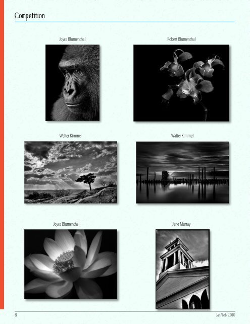
CompetitionJoyce BlumenthalRobert BlumenthalWalter KimmelWalter KimmelJoyce BlumenthalJane Murray8 Jan/Feb 2010
CompetitionAlbert TangRobert BlumenthalCOMPETITIONRESULTSRegular Competition #2BDec. 4, 2009—B&W/PrintsJudge: Chuck PineDigital Projector—B&W1st J. Blumenthal, R. Blumenthal, W. Kimmel2nd W. Kimmel3rd J. Blumenthal, J. Murray, A. TangHM R. Blumenthal, A. RainePrints—B&W1st J. Gordon, A. Raine2nd A. Raine, A. Raine3rd R. Baron, J. Gordon, R. KudelkaHM R. BaronAnn RainePrints—Color B1st A. Raine2nd R. Kudelka, A. Raine, A. Raine, F. Shapiro3rd J. Ferreira, J. FerreiraHM S. MigdalPrints—Color A & Salon1st Z. Kuo, A. Tang2nd R. Baron, J, Gordon, R. Kimmel, R. Kimmel,W. Kimmel, A. Tompkins3rd D. ThorntonHM J. Gordon, R. Kimmel, Z. Kuo, D. ThorntonPrints—Open Mind1st A. Tang2nd J. Gordon3rd J. GordonHM A. TangJobo PhotoGPSby Jonathan Lawton—Hunt’s Photo & VideoOver <strong>the</strong> last few years, geotagging photos has become increasinglypopular among photographers. Geotagging is <strong>the</strong> process <strong>of</strong> attachinggeographical information, such as <strong>the</strong> longitude and latitude, to photographswhen taken. Although <strong>the</strong> geotag capability has been around for years, onlyuntil recently has <strong>the</strong> size and usability changed. In <strong>the</strong> past, geotaggingrequired carrying a bulky GPS receiver and <strong>the</strong>n manually attaching <strong>the</strong>coordinates after photographing. This laborious task was typically executedonly by serious enthusiasts and pr<strong>of</strong>essionals.Thankfully, Jobo has made <strong>the</strong> process <strong>of</strong> geotagging more user-friendlywith <strong>the</strong>ir newly released PhotoGPS receiver. The device is compact, lightweight(2.7 x .8 x 1.7 inches), and designed to be mounted on <strong>the</strong> hotshoe <strong>of</strong>any camera.The PhotoGPS allows <strong>the</strong> photographer to take photos as usual; whenever<strong>the</strong> shutter button is pressed, <strong>the</strong> receiver automatically captures yourgeographical coordinates. That information is saved to <strong>the</strong> device’s internalmemory. Later when downloading your images to your computer, alsoconnect <strong>the</strong> PhotoGPS receiver to download <strong>the</strong> GPS data. After running <strong>the</strong>PhotoGPS s<strong>of</strong>tware, each photo will be tagged with its GPS coordinates aswell as o<strong>the</strong>r important information such as country name, state, city, postalcode, street name, and nearby points <strong>of</strong> interest.The PhotoGPS helps you easilyorganize and archive your photosby geographical location. Ano<strong>the</strong>rgreat advantage <strong>of</strong> geotagging is <strong>the</strong>ability to see <strong>the</strong> exact location on amap where your photos were takenwhen using websites such as Flickrand Google Earth. The PhotoGPS isa great device to add to your camerabag. Whe<strong>the</strong>r you are a pr<strong>of</strong>essional photographer with thousands <strong>of</strong> pictureto organize or an enthusiast looking for an interesting way to display yourvacation photos on a map, <strong>the</strong> Jobo PhotoGPS is an invaluable tool.The Jobo PhotoGPS includes, <strong>the</strong> receiver, a USB cable, user’s manual, a CD-ROM featuring PhotoGPS matching s<strong>of</strong>tware for Geocoding.Jon Lawton is a sales associate at Hunt’s Photo and Video in Melrose, MA. He is a 2003graduate from <strong>the</strong> Rochester Institute <strong>of</strong> Technology, where he studied photojournalism.He operates a photography business, specializing in wedding and portrait photography.(www.jonathanlawton.com)If you have any questions on <strong>the</strong> Jobo PhotoGPS or any o<strong>the</strong>r photo related topic, feelfree to contact me at jlawton@wbhunt.com, or at <strong>the</strong> store at 1-800-221-1830.Jan/Feb 2010 9