Bicycle Facilities Guide for Recreational Riding - Toledo ...
Bicycle Facilities Guide for Recreational Riding - Toledo ...
Bicycle Facilities Guide for Recreational Riding - Toledo ...

Create successful ePaper yourself
Turn your PDF publications into a flip-book with our unique Google optimized e-Paper software.
6. OREGON BIKE NETWORK<br />
The City of Oregon is developing a network to create a route from the Maumee River to Maumee Bay State Park,<br />
with connections to many Oregon locations including schools, Pearson Metropark, and Oregon’s Municipal Complex.<br />
Currently constructed or funded parts:<br />
•Starr Avenue Bike Lanes: 1.9 miles. Paved bike lanes, from Wheeling Street to Pearson Park at the<br />
intersection of Lallendorf Road. (There are also paths in Pearson Park — see 14.)<br />
•Pearson Park Connector: 1.0-mile, 10-foot-wide paved path connecting from Starr Avenue Bikeway<br />
to the Municipal Complex Connector, running on the north side of Starr Avenue from Lallendorf Road to<br />
Wynn Road.<br />
•Municipal Complex Connector Phase 1: 0.8-mile, 10-foot-wide paved path from Wynn Road to City<br />
of Oregon Municipal & <strong>Recreational</strong> Complex along Starr Avenue and Wolf Creek. Parking to be available<br />
at Oregon Municipal Complex off Seaman Road.<br />
•Stadium Road Bikeway Phase 1: 0.6-mile, paved path. Starts at corner of Stadium & Bayshore roads<br />
(at South Shore Veterans Park), and runs to Eagle’s Landing Golf Course and Subdivision.<br />
•Bayshore Road Bike Path: 1.2-mile, paved bike path along Bayshore Road. Begins at Stadium Road<br />
at South Shore Veterans Park and the James A. Haley Boardwalk. The path continues east to Maumee<br />
Bay State Park, connecting to park roads and trails. (See 14.) Parking available at South Shore Park.<br />
Contact: City of Oregon Dept. of Public Service, 419.698.7047.<br />
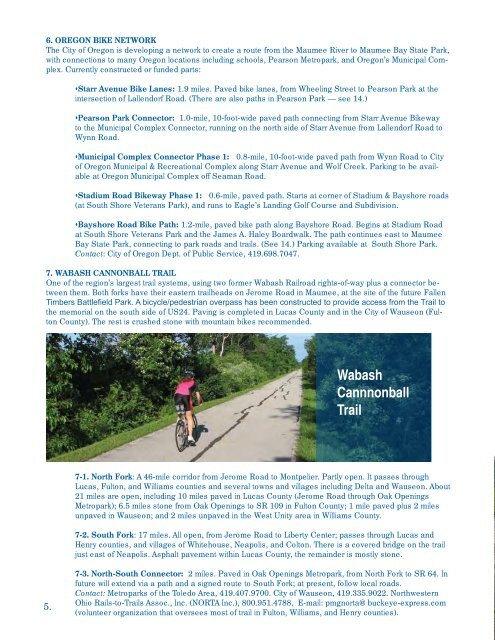
7. WABASH CANNONBALL TRAIL<br />
One of the region’s largest trail systems, using two <strong>for</strong>mer Wabash Railroad rights-of-way plus a connector between<br />
them. Both <strong>for</strong>ks have their eastern trailheads on Jerome Road in Maumee, at the site of the future Fallen<br />
Timbers Battlefield Park. A bicycle/pedestrian overpass has been constructed to provide access from the Trail to<br />
the memorial on the south side of US24. Paving is completed in Lucas County and in the City of Wauseon (Fulton<br />
County). The rest is crushed stone with mountain bikes recommended.<br />
5.<br />
Wabash<br />
Cannnonball<br />
Trail<br />
7-1. North Fork: A 46-mile corridor from Jerome Road to Montpelier. Partly open. It passes through<br />
Lucas, Fulton, and Williams counties and several towns and villages including Delta and Wauseon. About<br />
21 miles are open, including 10 miles paved in Lucas County (Jerome Road through Oak Openings<br />
Metropark); 6.5 miles stone from Oak Openings to SR 109 in Fulton County; 1 mile paved plus 2 miles<br />
unpaved in Wauseon; and 2 miles unpaved in the West Unity area in Williams County.<br />
7-2. South Fork: 17 miles. All open, from Jerome Road to Liberty Center; passes through Lucas and<br />
Henry counties, and villages of Whitehouse, Neapolis, and Colton. There is a covered bridge on the trail<br />
just east of Neapolis. Asphalt pavement within Lucas County, the remainder is mostly stone.<br />
7-3. North-South Connector: 2 miles. Paved in Oak Openings Metropark, from North Fork to SR 64. In<br />
future will extend via a path and a signed route to South Fork; at present, follow local roads.<br />
Contact: Metroparks of the <strong>Toledo</strong> Area, 419.407.9700. City of Wauseon, 419.335.9022. Northwestern<br />
Ohio Rails-to-Trails Assoc., Inc. (NORTA Inc.), 800.951.4788, E-mail: pmgnorta@buckeye-express.com<br />
(volunteer organization that oversees most of trail in Fulton, Williams, and Henry counties).