An investigation on plant species diversity in Colchic Province (Turkey)
An investigation on plant species diversity in Colchic Province (Turkey)
An investigation on plant species diversity in Colchic Province (Turkey)

Create successful ePaper yourself
Turn your PDF publications into a flip-book with our unique Google optimized e-Paper software.
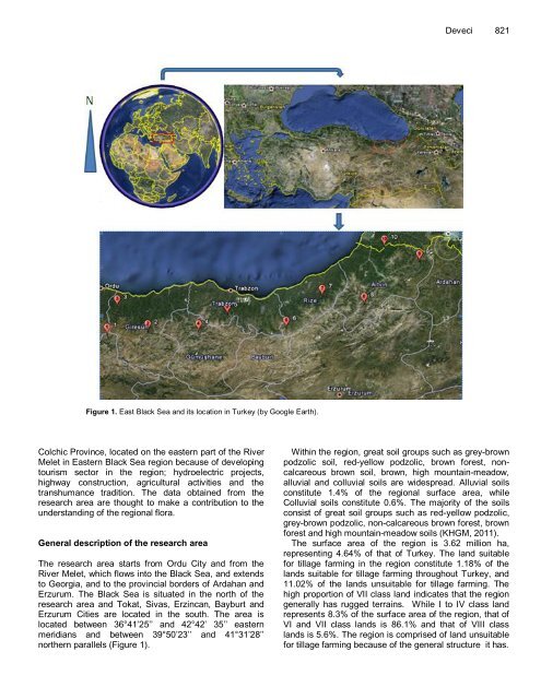
Figure 1. East Black Sea and its locati<strong>on</strong> <strong>in</strong> <strong>Turkey</strong> (by Google Earth).<br />
<strong>Colchic</strong> Prov<strong>in</strong>ce, located <strong>on</strong> the eastern part of the River<br />
Melet <strong>in</strong> Eastern Black Sea regi<strong>on</strong> because of develop<strong>in</strong>g<br />
tourism sector <strong>in</strong> the regi<strong>on</strong>; hydroelectric projects,<br />
highway c<strong>on</strong>structi<strong>on</strong>, agricultural activities and the<br />
transhumance traditi<strong>on</strong>. The data obta<strong>in</strong>ed from the<br />
research area are thought to make a c<strong>on</strong>tributi<strong>on</strong> to the<br />
understand<strong>in</strong>g of the regi<strong>on</strong>al flora.<br />
General descripti<strong>on</strong> of the research area<br />
The research area starts from Ordu City and from the<br />
River Melet, which flows <strong>in</strong>to the Black Sea, and extends<br />
to Georgia, and to the prov<strong>in</strong>cial borders of Ardahan and<br />
Erzurum. The Black Sea is situated <strong>in</strong> the north of the<br />
research area and Tokat, Sivas, Erz<strong>in</strong>can, Bayburt and<br />
Erzurum Cities are located <strong>in</strong> the south. The area is<br />
located between 36°41’25’’ and 42°42’ 35’’ eastern<br />
meridians and between 39°50’23’’ and 41°31’28’’<br />
northern parallels (Figure 1).<br />
Deveci 821<br />
With<strong>in</strong> the regi<strong>on</strong>, great soil groups such as grey-brown<br />
podzolic soil, red-yellow podzolic, brown forest, n<strong>on</strong>calcareous<br />
brown soil, brown, high mounta<strong>in</strong>-meadow,<br />
alluvial and colluvial soils are widespread. Alluvial soils<br />
c<strong>on</strong>stitute 1.4% of the regi<strong>on</strong>al surface area, while<br />
Colluvial soils c<strong>on</strong>stitute 0.6%. The majority of the soils<br />
c<strong>on</strong>sist of great soil groups such as red-yellow podzolic,<br />
grey-brown podzolic, n<strong>on</strong>-calcareous brown forest, brown<br />
forest and high mounta<strong>in</strong>-meadow soils (KHGM, 2011).<br />
The surface area of the regi<strong>on</strong> is 3.62 milli<strong>on</strong> ha,<br />
represent<strong>in</strong>g 4.64% of that of <strong>Turkey</strong>. The land suitable<br />
for tillage farm<strong>in</strong>g <strong>in</strong> the regi<strong>on</strong> c<strong>on</strong>stitute 1.18% of the<br />
lands suitable for tillage farm<strong>in</strong>g throughout <strong>Turkey</strong>, and<br />
11.02% of the lands unsuitable for tillage farm<strong>in</strong>g. The<br />
high proporti<strong>on</strong> of VII class land <strong>in</strong>dicates that the regi<strong>on</strong><br />
generally has rugged terra<strong>in</strong>s. While I to IV class land<br />
represents 8.3% of the surface area of the regi<strong>on</strong>, that of<br />
VI and VII class lands is 86.1% and that of VIII class<br />
lands is 5.6%. The regi<strong>on</strong> is comprised of land unsuitable<br />
for tillage farm<strong>in</strong>g because of the general structure it has.