The TOPMODEL Topographic Index In JULES
The TOPMODEL Topographic Index In JULES
The TOPMODEL Topographic Index In JULES
- No tags were found...

Create successful ePaper yourself
Turn your PDF publications into a flip-book with our unique Google optimized e-Paper software.
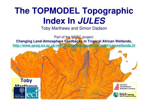
<strong>The</strong> <strong>TOPMODEL</strong> <strong>Topographic</strong><strong><strong>In</strong>dex</strong> <strong>In</strong> <strong>JULES</strong>Toby Marthews and Simon DadsonPart of the NERC project:Changing Land-Atmosphere Feedbacks in Tropical African Wetlands,http://www.geog.ox.ac.uk/research/landscape/projects/africanwetlands.htmlTobyMarthewsEdinburgh, 20th Jun 2013
A calculator for the TOPOGRAPHIC INDEX, as used in the <strong>TOPMODEL</strong> modelTranslated from various C and FORTRAN sources into R and then back into FORTRAN by Toby Marthews, 2012-13.<strong>The</strong> topographic index is a parameter that was introduced as part of the fine-scale <strong>TOPMODEL</strong>hydrological model (Beven & Kirkby 1979, Beven 1997, 2012), arguably the most widely-usedhydrological model.Beven KJ & Kirkby MJ (1979). A physically based, variable contributing area model of basin hydrology.Hydrological Sciences - Bulletin des Sciences Hydrologiques 24:43-69.Quinn P, Beven K, Chevallier P & Planchon O (1991). <strong>The</strong> prediction of hillslope flow paths for distributedhydrological modelling using digital terrain models. Hydrological Processes 5:59-79.Wolock DM & McCabe GJ (1995). Comparison of single and multiple flow direction algorithms forcomputing topographic parameters in <strong>TOPMODEL</strong>. Water Resources Research 31:1315-1324.Quinn PF, Beven KJ & Lamb R (1995). <strong>The</strong> ln(a/tanβ) index: how to calculate it and how to use it withinthe <strong>TOPMODEL</strong> framework. Hydrological Processes 9:161-182.Beven K (1997). <strong>TOPMODEL</strong>: a critique. Hydrological Processes 11:1069-1085.Ducharne A (2009). Reducing scale dependence in <strong>TOPMODEL</strong> using a dimensionless topographic index.Hydrology and Earth System Sciences 13:2399-2412.Beven K (2012). Rainfall-Runoff Modelling <strong>The</strong> Primer (2nd ed.). Wiley-Blackwell, Chichester, UK.
A calculator for the TOPOGRAPHIC INDEX, as used in the <strong>TOPMODEL</strong> modelTranslated from various C and FORTRAN sources into R and then back into FORTRAN by Toby Marthews, 2012-13.<strong>The</strong> topographic index at any particular spatial point is basically log(area)/slope wherearea is the drainage area above that point.<strong>The</strong>re are various alternative ways of calculating the topographic index:1.<strong>The</strong> topmodel R package, written in 2008 by Wouter Buytaert, Imperial CollegeLondon (http://cran.r-project.org/web/packages/topmodel/index.html; programs topidx.cand topidx.R)2.GRIDATB version 95.01 (program gridatb.f), originally written in 1983 by Keith Bevenof the Hydrology Group, Lancaster University (revised for distribution 1993-95 by PaulQuinn and Jim Freer).3.A simpler algorithm not based on an iterative search which I’ll call calcslope.f90.4.Using GRIDATB but with slopes calculated from steepest descent and usingprecalculated contributing areas from HydroSHEDS (Bernhard Lehner).
<strong>In</strong>flow contourOutflow contourtan(β) = Average slope acrossoutflow contour (orange)Following topidx.ctan(β’) = Average slope acrossnon-outflow contour (blue+black)clout = Weighted average of the noutflow (orange) lengths multipliedby n, where the weights are tan(β)for the slope across each outflowlength.a = Specific catchment area =A/cloutDX = Cell sidelength (the black square)<strong>Topographic</strong> indexfor this cell= ln(a/tan(β))except if clout=0 (i.e. the cell is adepression/sink point or on a plain) where:= ln(A/(2*tan(β’)))This is a visual explanation of the topographic index calculation, based on the octagon ofcontour lengths shown in Quinn et al. (1991:Fig.1). Note that the default value will be undefinedon any plain so I applied a minimum slope to all cells (from Hydro1k).
<strong>In</strong>flow contourOutflow contourtan(β) = Average slope acrossoutflow contour (orange)tan(β’) = Average slope acrossnon-outflow contour (blue+black)clout = Weighted average of the noutflow (orange) lengths multipliedby n, where the weights are tan(β)for the slope across each outflowlength.a = Specific catchment area =A/cloutDX = Cell sidelength (the black square)Following gridatb.f<strong>Topographic</strong> indexfor this cell= ln(a/tan(β))except if clout=0 (i.e. the cell is adepression/sink point or on a plain) where:= ln(A/(2*DX*tan(β’)))Note the small difference in the default value for sink cells.
<strong>In</strong>flow contourOutflow contourtan(β) = Slope across outflowcontour (orange)Following calcslope.f90clout = <strong>The</strong> outflow (orange) lengtha = Specific catchment area =A/cloutDX = Cell sidelength (the black square)<strong>Topographic</strong> indexfor this cell= ln(a/tan(β))except if clout=0 (i.e. the cell is adepression/sink point or on a plain) where:= [undefined]This program used a single flow direction algorithm to calculate slopes (only one orange contourand one blue contour for each cell) and no default values for sink points.
<strong>In</strong>flow contourOutflow contourFollowing Option #4All as for GRIDATB inc. defaultvalues<strong>Topographic</strong> indexfor this cell= ln(a/tan(β))Single inflow and outflow, but contributing areas A are validated by HydroSHEDS to correspondmore closely with more sophisticated routing models.
<strong>In</strong>put DEM for an area in SE Tanzania<strong>The</strong> resolution issue(Wolock & McCabe1995, Ducharne 2009).GRIDATB and topidx.cfollow iterativesearches, which arecomputationallydemanding.
Here’s what you get from topidx.c:Low values = relativelylittle upslope contributinginflow area and steepslopes (typically alongridges and hilltops)High topographic indexvalues = large contributingareas and shallow slopes(typically at the base ofhillslopes and near streams)
Here’s what you get from gridatb.f:
Here’s what you get from calcslope.f90:
Here’s what you get from Option #4:
HydroSHEDSDEM andcontributingareasconverted toNetCDF<strong>Topographic</strong>indexcalculator(available in Ror FORTRAN)NetCDFoutput file oftopographicindex valueson same gridas input (alsoin line with CFand WATCHconventions)
Marthews TR, Dadson SJ & Lehner BL (in prep.). Using the topographic index to characterise overlandand soil water flow in African wetlands.
Marthews TR, Dadson SJ & Lehner BL (in prep.). Using the topographic index to characterise overlandand soil water flow in African wetlands.
Marthews et al. (submitted). Hydraulic parameter maps of surface soils in tropical South Americaderived from locally-validated pedotransfer functions. Water Resources Research.A quick advert for a paper I’ve submittedwhere I’m trying to revise some modellingissues to do with the soil hydraulicsmodels (van Genuchten, etc.).
TobyMarthewsEdinburgh, 20th Jun 2013Thanks very much for listening.