Lithological Stratigraphic column for Badlands National Park By ...
Lithological Stratigraphic column for Badlands National Park By ...
Lithological Stratigraphic column for Badlands National Park By ...
- No tags were found...

Create successful ePaper yourself
Turn your PDF publications into a flip-book with our unique Google optimized e-Paper software.
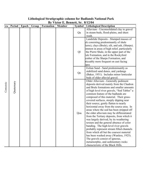
<strong>Lithological</strong> <strong>Stratigraphic</strong> <strong>column</strong> <strong>for</strong> <strong>Badlands</strong> <strong>National</strong> <strong>Park</strong><strong>By</strong> Victor E. Bennett, Sr. 8/12/04Era Period Epoch Group Formation Member Symbol <strong>Lithological</strong> DescriptionAlluvium - Unconsolidated clay to gravelQa in steam-beds, flood-plains, and sheetwash.Landslide Deposits - Slumped masses ofock consisting predominantly of shalePierre), clays (Brule), silt, and ash, (Sharps).ommon in areas of high relief, particularlyQl the Pierre Shale, in the upper part of therule Formation, and in the Rocky<strong>for</strong>dMember of the Sharps Formation, andoticeably more frequent on east facingopesEolian Sand - Sand predominantly asstabilized sand dunes, and yardangsQe(Baker, 1951). Includes minor lenticularbeds of older alluvial gravel.Older Alluvium - Generally pedimentdeposits derived mainly from the Chadronand Brule <strong>for</strong>mations and smaller amountsof high level river gravels, “Sod Tables” acommon feature of the badlands arecomposed of this material. Their grasscoveredsurfaces, steeply dipping neartheir source, gently flatten to nearlyhorizontal away from the source area. Inareas where the sod has been stripped offQoa the older alluvium may be differentiatedfrom the Tertiary deposits, from which itwas largely derived, by its weatheringtexture and the general absence of colorbanding. The high-level river gravelsprobably represent stream filled channelsfrom which all but the coarsest materialhas been washed away (Wanless, 1925).The gravels consist of igneous,metamorphic, and sedimentary rockscharacteristic of the Black Hills.Quaternary
TertiaryMioceneOligoceneArikareeWhite RiverSharps FormationBrule FormationRocky<strong>for</strong>dPOLESLIDESCENICTsTbSharps Formation of Harksen (1960) -Massive poorly consolidated pinkish-tansilt containing calcareous concretions,local lenses of freshwater limestone,clastic dikes, and chalcedony veinlets.The basal unit is the Rocky<strong>for</strong>d Member ofNicknish and McDonald (1962), is aconspicuous white locally silty zeolithicvolcanic ash as much as 15 m thick. Inmany places generally between Cedar Passand the Pinnacles, the basal unit is astream-channel fill consisting of pebbleconglomerate made up largely offragments of calcareous nodules derivedfrom ash layers and quarts sand in theupper part of the Brule. Rocks of theSharps Formation are found capping onlythe highest levels of the badlands; theygenerally <strong>for</strong>m a flat barren highlandstudded with very sharp spires and nearvertical walls <strong>for</strong>med by clastic dikes. Thelithology of the Sharps Formation issimilar to that of the underlying BruleFormation, but the color of the SharpsFormation above the Rocky<strong>for</strong>d Memberhas a somewhat more brownish tone thenthat of the underlying Brule Formation.About 100 m thickBrule Formation – Interbedded – pinkish –greenish – gray clay, silt, sand, andvolcanic ash containing channelsandstones, clastic dikes, and chalcedonyveinlets. Contains a conspicuous oreodonand turtle fauna. Rocks of this unitcompose most of the “wall of the<strong>Badlands</strong>” and many of the strikingbanded buttes. Due to its high content offine volcanic ash and calcareous cement,The Brule Formation characteristicallyweathers to very steep slopes and knife –edge ridges. This characteristic aloneprovides reasonably clear delineation ofthe Brule-Chadron contact in the badlands.As much as 150 m thick.
MesozoicLatePierre ShaleDegrayKpBlack shale – fissile, carbonaceous, poorlyresistant to weathering. Has layerscontaining large concretions and marinefossils. About 600 m thickReferencesRaymond, W. and King, R. (1976). Geologic Map Of The <strong>Badlands</strong> <strong>National</strong>Monument And Vicinity, West-Central South Dakota. U.S. Geological Survey,Map-I-934, 1:62,500Stoffer, P. (2003). Geology of <strong>Badlands</strong> <strong>National</strong> <strong>Park</strong>: A Preliminary Report.U.S. Geological Survey, O.F.R. 03-35.