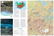
Snæfellsjökull National Park and Nearby ... - Umhverfisstofnun
Snæfellsjökull National Park and Nearby ... - Umhverfisstofnun
Snæfellsjökull National Park and Nearby ... - Umhverfisstofnun
- No tags were found...

You also want an ePaper? Increase the reach of your titles
YUMPU automatically turns print PDFs into web optimized ePapers that Google loves.
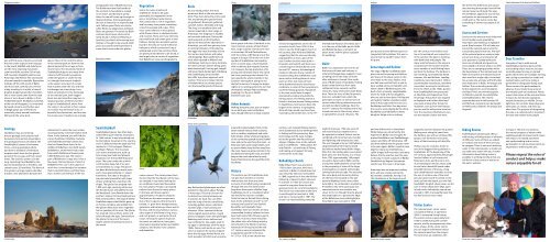
Djúpalónss<strong>and</strong>uryou will find areas of pumice <strong>and</strong> l<strong>and</strong>that was under a glacier not long ago.In the South, Mælifell <strong>and</strong> Axlarhyrnaare the most imposing mountainsseen from Búðir, <strong>and</strong> the 526 m hightuff mountain Stapafell watches overArnarstapi <strong>and</strong> Hellnar. The area boastsof some beautiful waterfalls. Bjarnarfosstumbles off the cliffs north of Búðir,<strong>and</strong> if you look carefully, you will seea lady st<strong>and</strong>ing in its midst, a haze ofdroplets draped around her shoulders.She is most clearly seen from the roadwhere it turns down to Búðir, or fromFróðárheiði heath. Klukkufoss waterfall,at the root of Hreggnasi, is surroundedby basalt columns, <strong>and</strong> further eastin Blágil gorge, you will find twowaterfalls, jointly named Þverfossar,falling into the same pool.glacier. Most of the rock formationsin the national park are from the lastglacial period of the ice age or fromrecent times. The mountains North ofSnæfellsjökull glacier are made fromvolcanic tuff, formed by eruptionsunder the glacier or under the sea.It is thought that mount Svalþúfais the eastern most part of a craterthat erupted under the sea, <strong>and</strong> thatLóndrangar are crater plugs. Lavafields are prevalent in the l<strong>and</strong>scapeof the national park, both raggedblock lava <strong>and</strong> smoother ropy lava. Alarge proportion of them have theirorigin in Snæfellsjökull, either fromthe crater in its summit or from cratersin its sides. You will find all sorts ofbeautiful lava formations, <strong>and</strong> the areahas many caves. Travellers are stronglyat Djúpasker, east of Búðahraun lava.The Búðahraun lava field st<strong>and</strong>s onthe sea bed, its foundations soakedin sea water, <strong>and</strong> during in springtides, the sea will come up through itsdeepest hollows. Among geologists,the lava is known for its triple-fleckedrock. Yellow-green flecks are olivine,white flecks are plagioclase <strong>and</strong> blackflecks are pyroxen. The beach by Búðircontains almost pure olivine s<strong>and</strong>,rarely found in Icel<strong>and</strong>. Hellnahraunlava field, just North of Arnarstapi <strong>and</strong>Hellnar, is thought to be around 4,000years old, <strong>and</strong> to have flowed from acrater that is now under the glacier.Djúpalónss<strong>and</strong>urVegetationSoil in the outer stretches ofSnæfellsnes tends to be quitepermeable, but vegetation in thearea is nonetheless quite diverse.The coastal area is rich in vegetation<strong>and</strong> has many clear ponds containingcolourful seaweed <strong>and</strong> cupus. Thickmoss covers the lava in most places,while flowers thrive in sheltered nooks<strong>and</strong> crannies. There aren’t any tall trees,but small birch <strong>and</strong> rowan grow in lavahollows. Among the rare plant speciesfound in the area are wood millet <strong>and</strong>herb paris, which is protected. Ling iswidespread, <strong>and</strong> in late summer, thereare plenty of wild berries to be found. Itwas largely due to variety of vegetationthat Búðahraun lava was designated aBirdsAs one would predict, the mostprominent birds in the area are seabirds. They nest along the entire coastline, <strong>and</strong> among the species foundare guillemot, Brunnich’s guillemot,razorbill, fulmar, kittiwake <strong>and</strong> shag.The shag is an excellent diver <strong>and</strong>can be inspected at close range atArnarstapi. The shag lays in huddleson low rocks <strong>and</strong> eyots. During thenesting period, a tuft of feathersadorns the head of the adult bird. InArnarstapi, you will also get very closeto nesting kittiwakes. Kittiwakes laytwo eggs into nests that they stick tothe narrow rock shelves with saliva<strong>and</strong> droppings. Black guillemots aremost often spotted at Malarrif <strong>and</strong>Lóndrangar. Gulls lay in many locations,the most common species being greatblack-backed gull, herring gull, seagull<strong>and</strong> lesser black-backed gull. Þúfubjarg<strong>and</strong> Saxhólsbjarg are accessiblebird cliffs, but please approach withcaution. There are no large coloniesof wetl<strong>and</strong> birds, but many speciesvisit the beautiful ponds of BeruvíkKittiwakesShagbrent goose <strong>and</strong> robin. Eiderduck is themost common species of duck foundhere. Large colonies of arctic tern nestin Arnarstapi, Rif <strong>and</strong> Öndverðarnes,with the colony at Rif being one of thelargest in Europe. The arctic tern is thesymbol of Snæfellsbær municipality,<strong>and</strong> is in some ways a charming bird,with its delicate but majestic features.It is, however, fiercely protective of itsyoung <strong>and</strong> will attack those who cometoo close, pecking at their heads. Thetern spends the winter months in theSouthern Hemisphere, along the iceshelf of Antarctica. To enjoy the brightnights in its nesting period, the tern hasdeveloped a unique flight technique,enabling it to fly up to 40,000kilometres per year.Other AnimalsWalking along the coast, you can expectto see both grey seals <strong>and</strong> harbourseals, though there are no large coloniesGufuskálavörerected at Ingjaldshóll, on the site ofan earlier church from 1200. At thetime, it was the third largest church inthe country, after Hólar <strong>and</strong> Skálholt,suggesting that the area was denselypopulated for at least a part of theyear. Further churches were built inEinarslón <strong>and</strong> Saxhóll, <strong>and</strong> there wasa small chapel in Öndverðarnes untilthe mid 16 th century. Archaeologicalevidence indicates that a number oflocations along the Snæfellsnes coastwere used as l<strong>and</strong>ing places at somepoint or other, but many of themwere ab<strong>and</strong>oned due to treacherousconditions, in spite of their proximity toexcellent fishing grounds. Populationin the area would have changeddramatically inside <strong>and</strong> outside thefishing season. The fishing station atDritvík is the best-known fishing stationin Snæfellsnes, having once been thelargest in the country. In springtime,40 to 60 ships would row from there,manned by 200 to 600 men. In the 19 ththe <strong>National</strong> Museum of Icel<strong>and</strong>, but itis in the care of the Búðir parish. Búðir<strong>and</strong> Búðakirkja have a romantic airabout them, <strong>and</strong> the place is popularfor weddings.BúðirBúðir is an important site in terms ofthe history of trade <strong>and</strong> industry inIcel<strong>and</strong>. Eyrbyggja Saga suggests it wasa trading port in the early centuriesafter settlement. Around 3 km southwestof Búðir hotel is Frambúðir. Fishingboats rowed from here from earlysettlement times onwards, <strong>and</strong> forcenturies, many l<strong>and</strong> owners kept boatshere. There are ruins of the fishermen’shuts (Ice: verbúdir) from which theplace gets its name, as well as ruins ofvarious other fishing-related structures,<strong>and</strong> old merchant buildings. Near themid 17 th century, the trading centre wasmoved east across the estuary whereit operated for around 130 years. TheHellnar<strong>and</strong> buried in three different parts onLaugarholt hill by Hellnar. This was toensure that he wouldn’t return fromhis grave.Arnarstapi <strong>and</strong> HellnarThe Saga of Bárður Snæfellsás takesplace around Arnarstapi <strong>and</strong> Hellnar,<strong>and</strong> many of the place names in thisarea relate to the story. Bárður, whowas half man <strong>and</strong> half troll, is said tohave walked ashore at Djúpalón <strong>and</strong>taken a bath in Bárðarlaug pool. Hebuilt a farm at nearby Laugarbrekkawhere he lived with his daughters,who are said to have been “full-figured<strong>and</strong> sightly”. Bárður’s brother Þorkelllived in Arnarstapi with his two sons,Rauðfeldur <strong>and</strong> Sölvi. One day whenthe cousins were playing by the shore,Rauðfeldur pushed Bárður’s oldestdaughter Helga onto an icebergthe 18 th century. Few families nowlive in Arnarstapi all year round, butin the summer, the place is teemingwith both birds <strong>and</strong> people. Themany summerhouses in the area areoccupied over the summer months,<strong>and</strong> a number of small fishing boatssail from the harbour. The harbour iseye-catching, surrounded by basaltcolumns, rifts <strong>and</strong> hollows. L<strong>and</strong>ingconditions were improved in 1933 toaccommodate motorboats, <strong>and</strong> thereis excellent mooring for small boats.From the 1930s to the 1960s, pumicefrom Snæfellsjökull was processedat Jökulháls <strong>and</strong> shipped out fromArnarstapi. The pumice was shippedto Reykjavík <strong>and</strong> further afield <strong>and</strong>was used, among other things, forinsulation. Just up from the harbour,you can see the old pumice store butnear the road over Jökulháls you cansee the wooden chutes that werethe theme ‘the fisherman <strong>and</strong> nature’,documenting how people lived off thenatural resources through the ages.The exhibition appeals to your senses,<strong>and</strong> guests are encouraged to taste,smell <strong>and</strong> try. The visitor centre hassomething of interest to people of allages.Access <strong>and</strong> ServicesServices in the area are much improvedsince travellers were greeted byAxlar-Björn <strong>and</strong> ended up in Iglutjörnpond. Road number 574 will take youaround the national park <strong>and</strong> to thesurrounding nature reserves. The staffof the national park are ready to helpyou as best they can <strong>and</strong> answer allyour questions. Guided walks <strong>and</strong>tours are scheduled, <strong>and</strong> guests areencouraged to find out what is on offer.There are no camping grounds withinthe boundaries of the national park, buthikers <strong>and</strong> cyclists are allowed to pitchtheir tent for a single night. Arnarstapihas a camp site, <strong>and</strong> you will find hotels<strong>and</strong> restaurants in Búðir, Arnarstapi <strong>and</strong>Hellnar. The surrounding areas offerfurther options for accommodation<strong>and</strong> food. There are swimming poolsin Ólafsvík, Lýsuhóll, Grundarfjörður<strong>and</strong> Stykkishólmur. The nearestsupermarkets are in Helliss<strong>and</strong>ur, Rif<strong>and</strong> Ólafsvík, <strong>and</strong> petrol can be boughtin Helliss<strong>and</strong>ur, Ólafsvík, Arnarstapi <strong>and</strong>Vegamót.Coast between Arnarstapi <strong>and</strong> HellnarDear TravellerEveryone is free to walk aroundSnæfellsjökull national park <strong>and</strong> thesurrounding nature reserves, but youare kindly asked to stay on markedpaths where these are available. Driving<strong>and</strong> cycling is permitted on roads <strong>and</strong>marked tracks, <strong>and</strong> horse riding ispermitted on designated riding trails.Please contact the park wardens inadvance if you intend to go aroundthe national park on horseback. Pleaserespect the nature of the area <strong>and</strong> leaveit intact. Do not disturb vegetation,natural formations or wildlife. Do notlight fires. Do not litter. Keep dogs <strong>and</strong>other pets on a leash, <strong>and</strong> clean upafter them. The purpose of designatingthe area as a national park is to protectthe l<strong>and</strong> <strong>and</strong> enable more peopleGeologySnæfellsnes has an extremelydiverse geology, <strong>and</strong> contains rockformations from almost all periods inthe geological history of Icel<strong>and</strong>. TheSnæfellsjökull system of volcanoesforms a strong geological whole,<strong>and</strong> there is evidence of individualeruptions both from the last glacialperiod of the ice age, <strong>and</strong> from recenttimes. The volcanic system is 30 kmlong, stretching from Mælifell in theEast to Öndverðarnes in the West, <strong>and</strong>contains over 20 lava fields. The heart ofthe system is a large magma chamberthat lies a few kilometres beneath theLóndrangaradvised not to enter the caves unlessaccompanied by someone familiar withthem. In the lowl<strong>and</strong>, you will find thecraters Purkhólar, Hólahólar, Saxhólar<strong>and</strong> Öndverðarneshólar amidst lavathat has flowed from them. In themiddle of Búðahraun lava field st<strong>and</strong>sBúðaklettur, an 88-metre-high craterfrom which Búðahraun flowed some5,000-8,000 years ago. The easternpart of Búðahraun is ropy lava. It has afew caves, the best known of which isBúðahellir. This cave is the subject ofmuch lore. It was thought, for instance,that it was bottomless, <strong>and</strong> that therewas a tunnel connecting it to the seaSnæfellsjökullSnæfellsjökull glacier has often beencalled the king of Icel<strong>and</strong>ic mountains.At 1446 metres, it was long thought tobe the highest mountain in the country,<strong>and</strong> it is believed that the peak was firstreached in 1754, by Eggert Ólafsson<strong>and</strong> Bjarni Pálsson. The mountainis an active stratovolcano, built upfrom many lava fields <strong>and</strong> phreaticeruptions over the last 800 thous<strong>and</strong>years. The crater under the summitis 200 metres deep, full of ice <strong>and</strong>surrounded by icy crags. The glacierhas been diminishing in recent years<strong>and</strong> is now approximately 11 squarekilometres. The sides of the glacierare particularly beautiful, with ropesof lava winding their way down theslopes. The glacier last erupted near1,800 years ago, spouting ashes overthe Northern part of Snæfellsnes <strong>and</strong>the Westfjords. Lava flowed down thesouthern slopes, forming Háahraun lavafield, among others. The Saga of BárðurSnæfellsás reports that Bárður gave upon human company <strong>and</strong> walked intothe glacier. Many have since regardedhim as guardian of the area. The glacierhas inspired many authors, poets <strong>and</strong>artists through the ages. Some believethe glacier to be one of the sevenlargest centers of spiritual sources inthe world.Fernsnature reserve. This variety stems fromthe fact that the foundations of the lavaare steeped in sea water, making theair conditions humid <strong>and</strong> favourablefor many plants. Peculiar cup-shapedhollows have formed in many placesin the lava, <strong>and</strong> these supportapproximately 130 species of plants.The ferns are the most conspicuous.Out of the 16 species of fern found inIcel<strong>and</strong>, 11 grow here. Meadowsweets,geraniums <strong>and</strong> buttercups thrive well inthe lava, <strong>and</strong> the lava harbours variousother types of wild flowers, ling, moss<strong>and</strong> rock growth, as well as birch <strong>and</strong>rowan. Among the species found onthe s<strong>and</strong>s are red fescue, lyme grass,silverweed, meadow buttercup, bladdercampion, wild thyme, moss campion<strong>and</strong> d<strong>and</strong>elion.Arctic terns quarrelingbay. Red-necked phalaropes are oftenspotted on the ponds above Pumpain Arnarstapi. This bird is known forits distinctive circling behaviour asit searches for food. You can oftenhear the song of various small birds,including golden plover, whimbrel,meadow pipit, snow bunting <strong>and</strong>wheatear. Other common birds arewhite wagtail, oystercatcher, ringedplover, s<strong>and</strong>piper, raven <strong>and</strong> ptarmigan.Redwings nest in lava hollows <strong>and</strong>near settlements. Sea eagles used tolay eggs in Lóndrangar until the early1900s. Falcon <strong>and</strong> merlin are rare. Thearea is a stopover for various migrantbirds that lay eggs further North, themost prevalent of which are turnstone,around the national park. Pools on thebeach contain various small creatures,such as cochlea, amphipods <strong>and</strong> crabs.Killer whales, minke whales <strong>and</strong> porpoisesare commonly spotted around Snæfellsnes,<strong>and</strong> can be seen from the coast – sokeep your eyes open! Large whales, suchas sperm whales, keep further away fromthe coast. Foxes are quite common in thelava fields <strong>and</strong> along the coast, <strong>and</strong> minkkeep to the coast where food is easilyfound. Field mice live the good life in thelava fields.HistoryThe western part of Snæfellsnes doesnot get much mention in ancientmanuscripts, but there are someaccounts of stockfish being transportedthrough the area. The best knownSaga from these parts is Bárðar SagaSnæfellsáss, but it is considered rathertoo fanciful to count as a reliablehistorical source. Ruined farms datingback to the settlement era (9 th to 10 thcentury) are found in Forni-Saxhóll,Berutóftir <strong>and</strong> Írskubúðir. NearGufuskálar, there are remains of manystonewalled shelters, believed to havebeen built some 500-700 years ago tostore fish. If correct, these would bethe oldest relics of a fishing industryto be found in the Nordic Countries.Advances in fishing around the mid13 th century were accompanied bya population growth in the area.In 1317 or 1318, a new church wascentury, such isolated fishing stationswere ab<strong>and</strong>oned due to developmentsin fishing <strong>and</strong> fish processing. Newtechnology <strong>and</strong> life-style changesled to the growth <strong>and</strong> flourishing ofvillages. Villages close to the nationalpark in Snæfellsnes – Helliss<strong>and</strong>ur, Rif<strong>and</strong> Ólafsvík – are old hubs of fishing<strong>and</strong> trading, <strong>and</strong> support thrivingcommunities to this day.Búðakirkja ChurchBúðarkirkja church was erected in1703 by Bent Lárusson, who was amerchant in Búðir. It rotted down butwas rebuilt by Steinunn Sveinsdóttirin 1848. Legend has it that she did thisfollowing a request by Bent Lárussonin a dream. In 1984, the church wasmoved in one piece from the oldgraveyard onto its current foundations.The church was renovated to the formit was thought to have had in 1848,<strong>and</strong> was re-consecrated in 1987. Thechurch is a listed building owned byThe church at Búdirnight of 8 January 1799 saw some ofthe most ferocious weather ever tobe reported in Icel<strong>and</strong>. Violent stormscombined with torrential rain, thunder<strong>and</strong> lightning <strong>and</strong> tempestuous seas.The surf charged as far as 1500 fathoms(approximately 2700 metres) inl<strong>and</strong><strong>and</strong> almost washed away Búðir village.After this, the trading place was movedback west over the estuary. In a censusfrom 1703, approximately 100 peopleare said to have lived in Búðir, <strong>and</strong> fora long time, Búðir played a central rolein the prosperity of some of the largermunicipalities in Icel<strong>and</strong>, with peoplecoming from afar to trade. The area alsohas some dark <strong>and</strong> menacing history.On the farm Öxl, located on the oldnational highway, lived a man calledAxlar-Björn. He confessed to murdering9 travellers who were passing by, butsome believe the true number wascloser to 18. It is thought that he placedthe dead bodies in a pond at the edgeof the Búðahraun lava called Iglutjörn.Axlar-Björn was executed in 1596<strong>and</strong> she drifted over to Greenl<strong>and</strong>.While Helga was unharmed by thisexperience, Bárður was enraged. Hepushed Rauðfeldur into Rauðfeldargjácanyon <strong>and</strong> Sölvi off Sölvahamar cliff<strong>and</strong> then walked into the glacier neverto be seen again. Bárður is said to havekept his treasures in Bárðarkista, acoffin-shaped tuff mountain, <strong>and</strong> manybelieve that he watches over the areato this day. A stone sculpture of BárðurSnæfellsnás by Ragnar Kjartanssonst<strong>and</strong>s near the coast in Arnarstapi.Arnarstapi was an important tradingport, <strong>and</strong> was a large communityby Icel<strong>and</strong>ic st<strong>and</strong>ards, having circa150 inhabitants at the beginning ofFrom the visitor centreoriginally used to transport the pumice.Walking west along the coast fromthe harbour, you will see striking cliffs,gorges, rock formations <strong>and</strong> caves,many of them teeming with bird life.Hellnar was, for centuries, home toone of the biggest fishing stations inSnæfellsnes. At the beginning of the18 th century, approximately 200 peoplelived at Hellnar in turf houses <strong>and</strong>fishermen’s huts, <strong>and</strong> the site is richin archaeological remains. Boats usedto row from a beautiful beach underGróuhóll hill. East of the bay, a longrock called Valasnös stretches out intothe sea. It contains one of the mostpeculiar caves found in Icel<strong>and</strong>. In therocks up from the beach, you will findSauðahellir (English: sheep cave), an oldcave in which sheep were kept, openin both ends. Hellnakirkja church waserected in 1945 in a beautiful spot thathas had a church since 1883.Visitor CentreThe national park’s visitor centreis located in Hellnar. It opened in2004, in renovated sheep houses.The visitor centre is open daily from10:00 to 18:00 during the summermonths, <strong>and</strong> by arrangement at othertimes of year. At the visitor centre,you can acquire information aboutthe national park from the rangers.The centre has an exhibition withHiking RoutesSnæfellsjökull national park offers awide variety of hiking routes of all levelsof difficulty. Some of them are stakedor marked, <strong>and</strong> most of them are easyto navigate. There is not much drinkingwater in the national park, so make sureyou take some water with you. Furtherinformation about hiking routes isavailable in a hiking brochure that youwill find in visitor centre as well as onthe park´s website.From the visitor centreto enjoy it. The aim is to preservethe natural progress of nature whileenabling people to interact with nature<strong>and</strong> enjoy it. Increased awareness<strong>and</strong> underst<strong>and</strong>ing <strong>and</strong> an activeparticipation in nature preservation areimportant to achieving this aim.Please respect the rules ofconduct <strong>and</strong> help us makenature enjoyable for all