30. LAKE SAKAKAWEA STATEPARK – Just east <strong>and</strong> north of Pick City.Paved access road, fish cleaning facility,developed <strong>and</strong> primitive camping, securitylights, picnic shelter, trash receptacles,concession, lodging, boat rental, accessfee, telephone, RV dump station – <strong>North</strong><strong>Dakota</strong> Parks <strong>and</strong> Recreation.31. GARRISON CREEK – 2 miles westof Garrison on ND Highway 37, 3 milessouth, 1 mile east. Gravel access road, norestrooms – Garrison Cabin Association.32. FORT STEVENSON STATE PARK –3 miles south of Garrison. Paved accessroad, fish cleaning facility, developed <strong>and</strong>primitive camping, security lights, picnicshelter, trash receptacles, concession,lodging, boat rental, access fee, telephone,RV dump station – <strong>North</strong> <strong>Dakota</strong> Parks<strong>and</strong> Recreation.33. STEINKE BAY – 3 miles west of thejunction of ND Highway 37 <strong>and</strong> U.S.Highway 83, then 2 miles south. Gravelaccess road, primitive camping – <strong>North</strong><strong>Dakota</strong> <strong>Game</strong> <strong>and</strong> <strong>Fish</strong> Department.34. SPORTSMENS CENTENNIALPARK – 1 mile west of the junction ofND Highway 37 <strong>and</strong> U.S. Highway 83,then 2 miles south, 1 mile west. Gravelaccess road, fish cleaning facility, developed<strong>and</strong> primitive camping, securitylights, picnic shelter, trash receptacles,concession, telephone – McLean CountyPark Board.35. WEST TOTTEN TRAIL – 7 milesnorth of Coleharbor on U.S. Highway83, then .5 miles west, or 2 miles south ofthe junction of U.S. Highway 83 <strong>and</strong> NDHighway 37, then .5 miles west. Gravelaccess road – McLean County ParkBoard.36. WOLF CREEK – 1 mile east of Riverdaleon ND Highway 200, then 2 milesnorth, 1 mile east, 1 mile north, .5 mileseast. Gravel access road, fish cleaningfacility, primitive camping, security lights,picnic shelter, trash receptacles, RV dumpstation – U.S. Army Corps of Engineers.37. GOVERNMENT BAY – Just north ofRiverdale. Paved access road, fish cleaningfacility, developed <strong>and</strong> primitive camping,security lights, trash receptacles – U.S.Army Corps of Engineers.38. GARRISON DAM TAILRACE –Directly below Garrison Dam with thecampground located south of the fishhatchery. Paved access road, fish cleaningfacility, developed camping, securitylights, trash receptacles – U.S. ArmyCorps of Engineers.39. UPA SITE (STANTON) – Just west ofUPA Power Plant on ND Highway 200Anear Stanton. Paved access road, securitylights, trash receptacles – City of Stanton.40. WASHBURN – On east side of theMissouri River near Washburn, northof ND Highway 200A bridge. Pavedaccess road, fish cleaning facility, primitivecamping, security lights, trash receptacles,RV dump station – Washburn City ParkBoard.41. SANGER (CROSS RANCH) – Justeast of Sanger townsite on west sideof Missouri River. Gravel access road,primitive camping, picnic shelter, trashreceptacles – <strong>North</strong> <strong>Dakota</strong> Parks <strong>and</strong>Recreation.42. STECKEL BOAT LANDING (WIL-TON) – 22 miles north of Bismarck onND Highway 1804, or 5.5 miles west, 1mile south, <strong>and</strong> 1.5 miles west of junctionof U.S. Highway 83 <strong>and</strong> ND Highway36. Paved access road, primitive camping,picnic shelter, trash receptacles – BurleighCounty Park Board.43. HOGE LANDING – On east side ofMissouri River near Bismarck, 6.4 milesnorth of I-94 bridge on River Road,then .7 miles west <strong>and</strong> 1.5 miles south/southwest. Gravel access road, no courtesydocks, picnic shelter, trash receptacles –Bismarck Parks <strong>and</strong> Recreation.44. KNIEFEL LANDING – On east side ofthe Missouri River near Bismarck, 3 milesnorth of I-94 bridge on River Road, then1 mile west. Paved access road, securitylights, picnic shelter, trash receptacles,concession – Burleigh County ParkBoard.45. GRANT MARSH BRIDGE – On eastside of Missouri River near Bismarck,south side of the I-94 bridge on RiverRoad. Paved access road, security lights,trash receptacles – Bismarck Parks <strong>and</strong>Recreation.46. FOX ISLAND PARK – From WashingtonStreet, .75 miles west on RiverwoodDrive (1 block south of Expressway),1.5 miles south <strong>and</strong> .5 miles west. Pavedaccess road, fish cleaning facility, securitylights, trash receptacles – Bismarck Parks<strong>and</strong> Recreation.47. LITTLE HEART BOTTOMS(SCHMIDT) – 11 miles south of M<strong>and</strong>anon ND Highway 1806, then 1 milenorth. Paved access road, trash receptacles– Morton County Park Board.48. KIMBALL BOTTOMS (DES-ERT) – 8 miles south of Bismarck onND Highway 1804, then 2 miles south.Paved access road, primitive camping,picnic shelter, trash receptacles – BurleighCounty Park Board.49. GRANER BOTTOMS (SUGARLOAF) – 19 miles south of M<strong>and</strong>an onND Highway 1806, then 1 mile east, orabout 3 miles north of Huff. Paved accessroad, fish cleaning facility, developed <strong>and</strong>primitive camping, security lights, picnicshelter, trash receptacles, RV dump station– Morton County Park Board.50. MACLEAN BOTTOMS (GUNRANGE) – 14 miles south of Bismarckon ND Highway 1804, then 2 milessouth. Paved access road, picnic shelter,trash receptacles – Burleigh County ParkBoard.51. HAZELTON – 31 miles southeast ofBismarck on ND Highway 1804 or 13miles west <strong>and</strong> 2 miles north of Hazelton.Campground located just south of boatramp. Paved access road, developed <strong>and</strong>primitive camping, security lights, picnicshelter, trash receptacles – U.S. ArmyCorps of Engineers.52. FORT RICE – 28 miles south ofM<strong>and</strong>an on ND Highway 1806, then .5miles east. Paved access road, fish cleaningfacility, primitive camping, security lights,picnic shelter, trash receptacles – MortonCounty Park Board.53. PRAIRIE KNIGHTS MARINA – 10miles south of the Cannonball River onND Highway 1806, then 3.5 miles east.Gravel access road, fish cleaning facility,developed <strong>and</strong> primitive camping, securitylights, picnic shelter, trash receptacles,lodging, telephone, RV dump station –Prairie Knights Casino.54. BEAVER BAY – 13 miles west of Lintonon ND Highway 13, then 2 miles southon ND Highway 1804. Paved accessroad, fish cleaning facility, developed <strong>and</strong>primitive camping, security lights, picnicshelter, trash receptacles, concession,telephone, RV dump station – U.S. ArmyCorps of Engineers.55. JENNERVILLE (RIVERY) – 13 mileswest of Linton on ND Highway 13, then6.5 miles south on ND Highway 1804,<strong>and</strong> 3.5 miles west at Rivery turnoff.Gravel access road, no restrooms, nocourtesy docks – U.S. Army Corps ofEngineers.56. CATTAIL BAY (WINONA) – 10 mileswest of Strasburg, 1 mile south, 7 mileswest, then 1 mile north on ND Highway1804, 2 miles west, 2 miles south, 1 milewest. Gravel access road, primitive camping,trash receptacles, concession – U.S.Army Corps of Engineers.57. FORT YATES – <strong>North</strong> edge of FortYates. Paved access road, primitive camping,picnic shelter, trash receptacles –St<strong>and</strong>ing Rock Sioux Tribe.58. LANGELIERS BAY – 10 miles west ofStrasburg, 1 mile south, 7 miles west, then11 miles south on ND Highway 1804,<strong>and</strong> .75 miles west. Paved access road, fishcleaning facility, primitive camping, securitylights, trash receptacles – EmmonsCounty Park Board.26 ND Outdoors <strong>March</strong>-<strong>April</strong> 2013
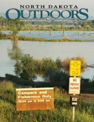
DEVILSLAKEBASINRON WILSON£¤281!( 17Following is a list of boating accesssites in the Devils Lake Basin (LakeIrvine, Devils Lake <strong>and</strong> Stump Lake) in<strong>North</strong> <strong>Dakota</strong>. All sites have a boat ramp,courtesy dock <strong>and</strong> restrooms unlessotherwise noted. For updated access information,check the <strong>North</strong> <strong>Dakota</strong> <strong>Game</strong><strong>and</strong> <strong>Fish</strong> Department’s website (gf.nd.gov)or contact the appropriate managingauthority noted at the end of each listing.1. PELICAN LAKE BAY – 15 miles westof Devils Lake on ND Highway 19.Paved access road, trash receptacles –<strong>North</strong> <strong>Dakota</strong> <strong>Game</strong> <strong>and</strong> <strong>Fish</strong> Department.2. MINNEWAUKAN CITY – East side ofthe city of Minnewaukan. Gravel accessroad, no restrooms, no courtesy docks, fishcleaning facility – Minnewaukan CommunityClub.3. ROUND LAKE BAY – 3 miles southof Minnewaukan on U.S. Highway 281.Paved access road, trash receptacles –Minnewaukan Community Club.4. GRAHAMS ISLAND STATEPARK – 10 miles west of Devils Lakeon ND Highway 19, then 6 miles south.Paved access road, fish cleaning facility,developed <strong>and</strong> primitive camping, securitylights, picnic shelter, trash receptacles,concession, lodging, access fee, telephone,RV dump station – <strong>North</strong> <strong>Dakota</strong> Parks<strong>and</strong> Recreation.5. SCHWAB LANDING – 7 miles westof Devils Lake on ND Highway 19.Paved access road, fish cleaning facility,developed <strong>and</strong> primitive camping, securitylights, picnic shelter, trash receptacles,concession, telephone,RV dumpstation – <strong>North</strong><strong>Dakota</strong> <strong>Game</strong> <strong>and</strong><strong>Fish</strong> Department.6. HENEGARLANDING – 1mile west of DevilsLake on NDHighway 19, then.75 miles south.Paved access road,fish cleaning facility,security lights,trash receptacles –Ramsey CountyPark Board.PelicanLake!7. CREEL BAY –3 miles southof Devils Lake on ND Highway 20,then 2 miles west <strong>and</strong> .25 miles north.Paved access road, fish cleaning facility,developed <strong>and</strong> primitive camping, securitylights, picnic shelter, trash receptacles –Ramsey County Park Board.8. SPIRIT LAKE CASINO – 6 milessouth of Devils Lake on ND Highway20/57. Paved access road, fish cleaningfacility, developed <strong>and</strong> primitive camping,security lights, trash receptacles, concession,lodging, boat rental, telephone, RVdump station – Spirit Lake Casino.9. EAST BAY – 3 miles south of DevilsLake on ND Highway 20. Paved accessroad, security lights, trash receptacles –<strong>North</strong> <strong>Dakota</strong> <strong>Game</strong> <strong>and</strong> <strong>Fish</strong> Department.10. ESTENSON LANDING – 15 milessouth of Devils Lake on ND Highway!!1WestBay3MinnewaukanFlats£¤2!(19!SixMile!5£¤ !( 57281 4Creel!BayMainBay!!8!( 206!109EastBay!BlackTiger!!(20£¤220. Paved access road, no restrooms, trashreceptacles – <strong>North</strong> <strong>Dakota</strong> <strong>Game</strong> <strong>and</strong><strong>Fish</strong> Department.11. BLACK TIGER BAY – 7.5 miles eastof Devils Lake on U.S. Highway 2, then6 miles south, 3 miles west. Gravel accessroad, no restrooms, no courtesy docks,concession – <strong>North</strong> <strong>Dakota</strong> Parks <strong>and</strong>Recreation.12. TOLNA LANDING (STUMPLAKE) – 3 miles north of Tolna. Gravelaccess road, fish cleaning facility, securitylights, picnic shelter, trash receptacles –Tolna Community Club.13. STUMP LAKE PARK – 11 miles south,1 mile west of Lakota. Paved accessroad, fish cleaning facility, developed <strong>and</strong>primitive camping, security lights, picnicshelter, trash receptacles, concession, lodging,RV dump station – Nelson CountyPark Board.<strong>March</strong>-<strong>April</strong> 2013 ND Outdoors 272711EastDevilsLake12StumpLake!!( 1!(15!!(113BRIAN HOSEK