Common Implementation Strategy for the Water Framework Directive
Common Implementation Strategy for the Water Framework Directive
Common Implementation Strategy for the Water Framework Directive

You also want an ePaper? Increase the reach of your titles
YUMPU automatically turns print PDFs into web optimized ePapers that Google loves.
WFD CIS Guidance Document No.9<br />
Implementing <strong>the</strong> Geographical In<strong>for</strong>mation Systems (GIS) of <strong>the</strong> <strong>Water</strong> <strong>Framework</strong> <strong>Directive</strong><br />
Table<br />
Table<br />
Data<br />
Data<br />
Geographic<br />
Geographic<br />
Dataset<br />
Dataset<br />
Table<br />
Table<br />
Data<br />
Data<br />
Table<br />
Table<br />
Data<br />
Data<br />
Map Map<br />
Geographic<br />
Geographic<br />
Dataset<br />
Dataset<br />
e.g., River Basin Districts (RBDs)<br />
Table<br />
Table<br />
Data<br />
Data<br />
Geographic<br />
Geographic<br />
Dataset<br />
Dataset<br />
Table<br />
Table<br />
Data<br />
Data<br />
e.g., RBD boundaries, main rivers,<br />
national borders, major cities<br />
Table<br />
Table<br />
Data<br />
Data<br />
e.g., structured organisation of data,<br />
such as a table of RBDs<br />
e.g., nodes of polygons, RBD name,<br />
country name, city name<br />
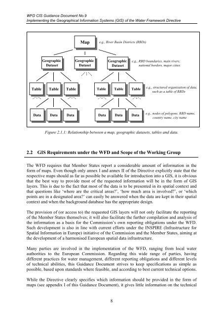
Figure 2.1.1: Relationship between a map, geographic datasets, tables and data.<br />
2.2 GIS Requirements under <strong>the</strong> WFD and Scope of <strong>the</strong> Working Group<br />
The WFD requires that Member States report a considerable amount of in<strong>for</strong>mation in <strong>the</strong><br />
<strong>for</strong>m of maps. Even though only annex I and annex II of <strong>the</strong> <strong>Directive</strong> explicitly state that <strong>the</strong><br />
respective maps should as far as possible be available <strong>for</strong> introduction into a GIS, it is obvious<br />
that <strong>the</strong> best way to provide most of <strong>the</strong> requested in<strong>for</strong>mation will be in <strong>the</strong> <strong>for</strong>m of GIS<br />
layers. This is due to <strong>the</strong> fact that most of <strong>the</strong> data is to be presented in its spatial context and<br />
that questions like ‘where are <strong>the</strong> critical areas?’, ‘how much area is involved?’, or ‘which<br />
points are in a designated area?’ can easily be answered when <strong>the</strong> data are kept in <strong>the</strong>ir spatial<br />
context and when <strong>the</strong> background database has <strong>the</strong> appropriate design.<br />
The provision of (or access to) <strong>the</strong> requested GIS layers will not only facilitate <strong>the</strong> reporting<br />
of <strong>the</strong> Member States <strong>the</strong>mselves; it will also facilitate <strong>the</strong> fur<strong>the</strong>r compilation and analysis of<br />
<strong>the</strong> in<strong>for</strong>mation as a basis <strong>for</strong> <strong>the</strong> Commission’s own reporting obligations under <strong>the</strong> WFD.<br />
Such development is also in line with current ef<strong>for</strong>ts under <strong>the</strong> INSPIRE (Infrastructure <strong>for</strong><br />
Spatial In<strong>for</strong>mation in Europe) initiative of <strong>the</strong> Commission and <strong>the</strong> Member States, aiming at<br />
<strong>the</strong> development of a harmonised European spatial data infrastructure.<br />
Many parties are involved in <strong>the</strong> implementation of <strong>the</strong> WFD, ranging from local water<br />
authorities to <strong>the</strong> European Commission. Regarding this wide range of parties, having<br />
different practices <strong>for</strong> water management, different reporting obligations and different levels<br />
of technical abilities, this Guidance Document strives to keep specifications as simple as<br />
possible, based upon standards where feasible, and according to best current technical options.<br />
While <strong>the</strong> <strong>Directive</strong> clearly specifies which in<strong>for</strong>mation should be provided in <strong>the</strong> <strong>for</strong>m of<br />
maps (see appendix I of this Guidance Document), it gives little in<strong>for</strong>mation on <strong>the</strong> technical<br />
8