Common Implementation Strategy for the Water Framework Directive
Common Implementation Strategy for the Water Framework Directive
Common Implementation Strategy for the Water Framework Directive

You also want an ePaper? Increase the reach of your titles
YUMPU automatically turns print PDFs into web optimized ePapers that Google loves.
WFD CIS Guidance Document No.9<br />
Implementing <strong>the</strong> Geographical In<strong>for</strong>mation Systems (GIS) of <strong>the</strong> <strong>Water</strong> <strong>Framework</strong> <strong>Directive</strong><br />
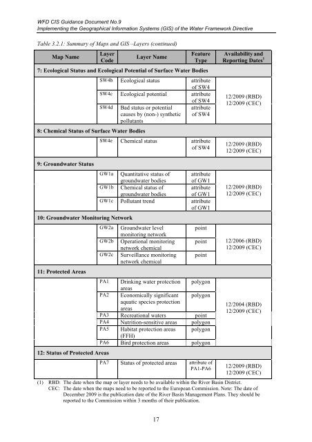
Table 3.2.1: Summary of Maps and GIS –Layers (continued)<br />
Map Name<br />
Layer<br />
Code<br />
Layer Name<br />
Feature<br />
Type<br />
7: Ecological Status and Ecological Potential of Surface <strong>Water</strong> Bodies<br />
SW4b Ecological status attribute<br />
of SW4<br />
SW4c Ecological potential attribute<br />
SW4d Bad status or potential<br />
causes by (non-) syn<strong>the</strong>tic<br />
pollutants<br />
8: Chemical Status of Surface <strong>Water</strong> Bodies<br />
9: Groundwater Status<br />
10: Groundwater Monitoring Network<br />
11: Protected Areas<br />
12: Status of Protected Areas<br />
of SW4<br />
attribute<br />
of SW4<br />
SW4e Chemical status attribute<br />
of SW4<br />
GW1a Quantitative status of attribute<br />
groundwater bodies of GW1<br />
GW1b Chemical status of attribute<br />
groundwater bodies of GW1<br />
GW1c Pollutant trend attribute<br />
of GW1<br />
GW2a Groundwater level<br />
monitoring network<br />
GW2b Operational monitoring<br />
network chemical<br />
GW2c Surveillance monitoring<br />
network chemical<br />
point<br />
point<br />
point<br />
PA1 Drinking water protection<br />
areas<br />
polygon<br />
PA2 Economically significant<br />
aquatic species protection<br />
areas<br />
polygon<br />
PA3 Recreational waters point<br />
PA4 Nutrition-sensitive areas polygon<br />
PA5 Habitat protection areas<br />
(FFH)<br />
polygon<br />
PA6 Bird protection areas polygon<br />
PA7 Status of protected areas attribute of<br />
PA1-PA6<br />
Availability and<br />
Reporting Dates 1<br />
12/2009 (RBD)<br />
12/2009 (CEC)<br />
12/2009 (RBD)<br />
12/2009 (CEC)<br />
12/2009 (RBD)<br />
12/2009 (CEC)<br />
12/2006 (RBD)<br />
12/2009 (CEC)<br />
12/2004 (RBD)<br />
12/2009 (CEC)<br />
12/2009 (RBD)<br />
12/2009 (CEC)<br />
(1) RBD: The date when <strong>the</strong> map or layer needs to be available within <strong>the</strong> River Basin District.<br />
CEC: The date when <strong>the</strong> maps need to be reported to <strong>the</strong> European Commission. Note: The date of<br />
December 2009 is <strong>the</strong> publication date of <strong>the</strong> River Basin Management Plans. They should be<br />
reported to <strong>the</strong> Commission within 3 months of <strong>the</strong>ir publication.<br />
17