Driscoll - Soil Fact Sheet 1 - The Forest Practices Authority
Driscoll - Soil Fact Sheet 1 - The Forest Practices Authority
Driscoll - Soil Fact Sheet 1 - The Forest Practices Authority

Create successful ePaper yourself
Turn your PDF publications into a flip-book with our unique Google optimized e-Paper software.
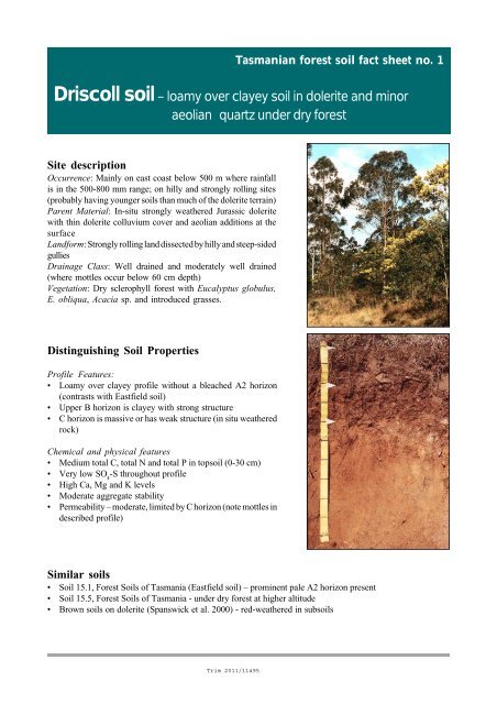
Tasmanian forest soil fact sheet no. 1<strong>Driscoll</strong> soil – loamy over clayey soil in dolerite and minoraeolian quartz under dry forestSite descriptionOccurrence: Mainly on east coast below 500 m where rainfallis in the 500-800 mm range; on hilly and strongly rolling sites(probably having younger soils than much of the dolerite terrain)Parent Material: In-situ strongly weathered Jurassic doleritewith thin dolerite colluvium cover and aeolian additions at thesurfaceLandform: Strongly rolling land dissected by hilly and steep-sidedgulliesDrainage Class: Well drained and moderately well drained(where mottles occur below 60 cm depth)Vegetation: Dry sclerophyll forest with Eucalyptus globulus,E. obliqua, Acacia sp. and introduced grasses.Distinguishing <strong>Soil</strong> PropertiesProfile Features:• Loamy over clayey profile without a bleached A2 horizon(contrasts with Eastfield soil)• Upper B horizon is clayey with strong structure• C horizon is massive or has weak structure (in situ weatheredrock)Chemical and physical features• Medium total C, total N and total P in topsoil (0-30 cm)• Very low SO 4-S throughout profile• High Ca, Mg and K levels• Moderate aggregate stability• Permeability – moderate, limited by C horizon (note mottles indescribed profile)Similar soils• <strong>Soil</strong> 15.1, <strong>Forest</strong> <strong>Soil</strong>s of Tasmania (Eastfield soil) – prominent pale A2 horizon present• <strong>Soil</strong> 15.5, <strong>Forest</strong> <strong>Soil</strong>s of Tasmania - under dry forest at higher altitude• Brown soils on dolerite (Spanswick et al. 2000) - red-weathered in subsoils
<strong>Soil</strong> Degradation PotentialFACTORRATING OF DEGRADATION POTENTIALErodibility:ModerateCompaction and puddling: ModerateMixing:ModerateNutrient depletion: Moderate (N and P)Landslides:ModerateFlooding:NegligibleSite ProductivityLow productivity, limited primarily by low moisture availability and low N, P and S availability<strong>Soil</strong> Management<strong>Soil</strong>s on hilly and steep slopes are prone to erosion following clearing and/or cultivation. Excessivedisturbance and burning will reduce productivity.Native <strong>Forest</strong> Logging and RegenerationLOGGING AND CLEARING:<strong>Soil</strong>s with few stones are unsuitable for wet-weather logging; bouldery and stony soils are suitable for wetweatherlogging provided soils are not saturated and runoff is minimised.PREPARATION FOR REGENERATION:Scarification of the soil surface or burning is required for good germination. Hot burns not recommendedbecause of low N status. Success of regeneration depends on moisture conditions.SILVICULTURAL CONSIDERATIONS:Low water availability limits long-term productivity. Long-term management as a low wood-productionforest following appropriate partial logging operations is likely to be the most viable option.Suitability for PlantationsMarginally suitable to unsuitable for plantations, limited by low productivity and droughtinessCLEARING: Care must be taken to retain the surface soilsCULTIVATION: Ripping to break up firm subsoils will be beneficialFERTILISER: N and P and S fertiliser is required at planting and secondary fertilisation is necessarythroughout the rotation
ProfileAuthors: MDL and PDMDate: 21.9.00Location: West side of Buckland Road, <strong>Driscoll</strong>s Hills, 4.5 km north of BucklandMap reference: <strong>Sheet</strong> 5428 (Buckland) 563 866Landform: Midslope of hilly gully side 100 m longVegetation: Eucalyptus globulus, Acacia dealbata, saggs, native cherry, grassesParent material: Dolerite colluvium on in situ-dolerite, with aeolian quartz sand in A horizonDrainage: Well drainedSlope: 18°Aspect: NortheastAltitude: 150 mPhotographs: PDM 10-00-4 (site); 9-00-13a (profile)Australian <strong>Soil</strong> Classification: Eutrophic Brown ChromosolA1 0-21 cm Dark greyish brown (10YR4/2) (moist) silty loam; 15% subrounded gravels 10-40 cm diameter; weak strength; weak 1-2 mm subangular blocky structure;abundant fine roots; NaF 0/5.B2 21-40 cm Brown (7.5YR4/3) (moist) medium clay; 15% subrounded gravels 10-40 cmdiameter; weak strength; strong 5-15 mm blocky structure; prominent darkbrown (7.5YR3/2) clay skins on block faces; many fine roots; NaF 0/5.B3 40-60 cm Brown (7.5YR4/4) (moist) coarse sandy loam; 10% subrounded gravels 10 cmdiameter; firm strength; weak 3-8 mm blocky structure breaking to 2 mmblocky; prominent dark brown (7.5YR3/2) clay skins on block faces; commonfine roots; NaF 0/5.C 60-100 cm Strong brown (7.5YR5/6) (moist) coarse sandy loam; 30% light olive brown(2.5Y5/3) mottles 20 mm diameter, below 80 cm depth; firm strength; massive;10% subrounded gravels 10 cm diameter; few roots; NaF 0/5; in situ weatheredrock.Laboratory AnalysesHorizonDepth(cm)pH(H 2 O)TotalC(%)TotalN(%)C/NColwellP(mg/kg)TotalP(mg/kg)P retn.(%)SO 4 -S(mg/kg)Waterstableaggreg.0-30 6.2 3.22 0.20 16 4 170 15 1 n.d.A1 0-21 6.0 5.13 0.30 17 6 205 17 1 47B2 21-40 6.5 1.95 0.15 13 3 89 30 1 64B3 40-60 6.7 0.40 0.04 10 n.d. 266 19 0 65C 60-90 7.1 0.13 0.02 8 n.d. 243 14 0 62(%)HorizonDepth(cm)Exch. Ca(cmol(+)/kg)Exch. Mg(cmol(+)/kg)Exch. K(cmol(+)/kg)Exch. Na(cmol(+)/kg)CEC(cmol(+)/kg)BS(%)0-30 14.68 4.71 0.25 0.20 18.4 108A1 0-21 15.68 4.38 0.34 0.19 22.0 94B2 21-40 16.31 8.04 0.08 0.41 23.7 105B3 40-60 12.12 6.54 0.05 0.69 17.5 111C 60-90 11.71 6.74 0.02 0.61 16.2 118Analytical methods were those of Blakemore et al. (1987), Laffan et al. (1996) and Rayment and Higginson(1992), with variation of methods for C, N and SO 4-S (details available from P. D. McIntosh, <strong>Forest</strong><strong>Practices</strong> Board).
ReferencesBlakemore, L. C.; Searle, P. L. and Daly, B. K. 1987. Methods of chemical analysis of soils. New Zealand <strong>Soil</strong> BureauScientific Report 80.Laffan, M. D.; Grant, J. and Hill, R. 1996. A method for assessing the erodibility of Tasmanian forest soils. AustralianJournal of <strong>Soil</strong> and Water Conservation 9: 16 – 22.Rayment, G. E. and Higginson, F. R. 1992. Australian Laboratory Handbook of <strong>Soil</strong> and Water Chemical Methods.Incarta Press, Melbourne, 330p.Spanswick, S.; Kidd, D.; Loveday, J. and Dimmock, G. M. 2000. Buckland <strong>Soil</strong> Report. A revised edition of DivisionalReport 13/57 Buckland. DPIWE, Tasmania, 44 pages plus map.AcknowledgementsTo Gunns Ltd and <strong>Forest</strong>ry Tasmania, for funding soil analyses.Citation:McIntosh, P.D.; Laffan, M.D.; Wong, L.; Miller, M. and Holz, G. 2001. <strong>Driscoll</strong> soil. Tasmanian forest soil fact sheet no.1. <strong>Forest</strong> <strong>Practices</strong> Board, Hobart; Gunns Ltd, Launceston and <strong>Forest</strong>ry Tasmania, Hobart. 4 p.July 2001