schedules - City of Brockville
schedules - City of Brockville
schedules - City of Brockville
You also want an ePaper? Increase the reach of your titles
YUMPU automatically turns print PDFs into web optimized ePapers that Google loves.
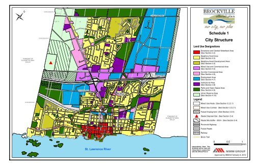
ÜCONCESSION 3LOT 171615141312 101198CENTENNIAL RD76LOT 1716151413WINDSOR DR1211109876Schedule 1CONCESSION 2<strong>City</strong> StructureSTEWART BLVDLand Use DesignationsTOWNSHIP OFELIZABETHTOWN-KITLEYN AUGUSTA RDDowntown and Central Waterfront Area(See Section 4.2)Neighbourhood Area(See Section 4.3)Neighbourhood Development Area(See Section 4.4)#HIGHWAY 401PARKEDALE AVEHIGHWAY 401Mixed Use and Commercial Area(See Section 4.5)Corridor Commercial Area(See Section 4.6)Employment Area(See Section 4.7)Institutional Area(See Section 4.8)CONCESSION 1CENTRAL AVE WCENTRALAVE ELegendParks and Open Space Area(See Section 4.9)Urban Reserve Area(See Section 4.10)Mixed Use Node (See Section 3.2.2.1)PERTH STWILLIAM STWALL STORMOND STPEARL ST EN AUGUSTA RDOXFORD AVETOWNSHIP OFELIZABETHTOWN-KITLEY#WasteMixed Use Corridor (See Section 3.2.2.1)Future Employment (See Section 3.2.5)Disposal Site (See Section 5.4)Waste Site Buffer - 500m (See Section 5.4)Provincial HighwayKING ST WKING ST EFuture RoadsRailwayBrock TrailSt. Lawrence RiverInterpretation Note: ThisSchedule will be read andinterpreted in conjunctionwith the Official Plan in0 0.5 1kmApproved by MMAH February 9, 2012
ÜCONCESSION 3LOT 17161514C13W12 101198CENTENNIAL RD76CONCESSION 2LOT 171615CN14SC13CSWINDSOR DR12CC11NN109876Schedule 3Natural Heritage System,Open Space & ConstraintsTOWNSHIP OFELIZABETHTOWN-KITLEY#HIGHWAY 401WPRSTEWART BLVDPARKEDALE AVENCENTRAL AVE WSSSSNPRWCENTRALAVE EWNSHIGHWAY 401NSN AUGUSTA RDParks and Open SpaceNCWPRCIPISNeighbourhood ParksCommunity Parks<strong>City</strong>-Wide ParksPrivate Recreational Areas<strong>City</strong> IslandPrivate IslandExisting and Proposed Elementaryor Secondary School SitesNatural Heritage FeaturesProvincially Significant WetlandsSignificant Woodlands(See Section 3.5.3.1)(See Section 3.6.5)CONCESSION 1WCPRKING ST WNNNCNCSNPERTH STCSNNWILLIAM STWALL STWNWCORMOND STSPEARL ST ECWN AUGUSTA RDNCCKING ST ECOXFORD AVEPRTOWNSHIP OFELIZABETHTOWN-KITLEYNatural HazardsLegend#WasteFlood HazardsScreening Area for the CataraquiRegion Conservation AuthorityDisposal SiteWaste Disposal Site Buffer - 500mProvincial HighwayFuture Roads(See Section 3.7.1)CICICIPICIWSection 3.5.3.1 PICIPICINPR WWWPRWSt. Lawrence RiverWCICIRailwayWatercourses and WaterbodiesInterpretation Note: ThisSchedule will be read andinterpreted in conjunctionwith the Official Plan in its0 0.5 1kmApproved by MMAH February 9, 2012
ÜCONCESSION 3LOT 171615141312 101198CENTENNIAL RD76LOT 1716151413WINDSOR DR1211109876Schedule 4CONCESSION 2Street NetworkSTEWART BLVDTOWNSHIP OFELIZABETHTOWN-KITLEYN AUGUSTA RDHierarchy <strong>of</strong> RoadsProvincial Highway (See Section 5.2.2.1)Arterial Road - 26-38m (See Section 5.2.2.2)Collector Road - 20-26m (See Section 5.2.2.3)!HIGHWAY 401PARKEDALE AVEHIGHWAY 401Local Road - up to 22m (See Section 5.2.2.4)Legend! Grade Separation ProposedRailwayFuture Roads!CENTRAL AVE WCENTRALAVE EWater Street Realignment OptionsOption ACONCESSION 1PERTH STWILLIAM STWALL STORMOND STPEARL ST EN AUGUSTA RDOXFORD AVETOWNSHIP OFELIZABETHTOWN-KITLEYOption BKING ST WKING ST ESt. Lawrence RiverSEE INSET FOR WATER STREETREALIGNMENT OPTIONSInterpretation Note: ThisSchedule will be read andinterpreted in conjunctionwith the Official Plan in its0 0.5 1kmApproved by MMAH February 9, 2012
ÜCONCESSION 3LOT 171615141312 101198CENTENNIAL RD76LOT 1716151413WINDSOR DR1211109876Schedule 5CONCESSION 2Active Transportation NetworkSTEWART BLVDTOWNSHIP OFELIZABETHTOWN-KITLEYN AUGUSTA RDLegendBrock TrailFuture Brock TrailPotential Spine Cycling RoutesHIGHWAY 401PARKEDALE AVEHIGHWAY 401Potential Neighbourhood Cycling RoutesWaterfront TrailProvincial HighwayRailwayFuture RoadsCENTRAL AVE WCENTRALAVE ECONCESSION 1PERTH STWILLIAM STWALL STORMOND STPEARL ST EN AUGUSTA RDOXFORD AVETOWNSHIP OFELIZABETHTOWN-KITLEYKING ST WKING ST ESt. Lawrence RiverInterpretation Note: ThisSchedule will be read andinterpreted in conjunctionwith the Official Plan in its0 10.5kmApproved by MMAH February 9, 2012


