The Lower St. Louis River Habitat Plan - Great Lakes Commission
The Lower St. Louis River Habitat Plan - Great Lakes Commission
The Lower St. Louis River Habitat Plan - Great Lakes Commission

You also want an ePaper? Increase the reach of your titles
YUMPU automatically turns print PDFs into web optimized ePapers that Google loves.
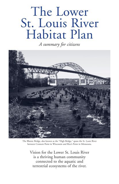
<strong>The</strong> <strong>Lower</strong><strong>St</strong>. <strong>Louis</strong> <strong>River</strong><strong>Habitat</strong> <strong>Plan</strong>A summary for citizens<strong>The</strong> Blatnic Bridge, also known as the “High Bridge,” spans the <strong>St</strong>. <strong>Louis</strong> <strong>River</strong>between Connors Point in Wisconsin and Rice’s Point in Minnesota.Vision for the <strong>Lower</strong> <strong>St</strong>. <strong>Louis</strong> <strong>River</strong>is a thriving human communityconnected to the aquatic andterrestrial ecosystems of the river.
Welcome to the <strong>Lower</strong> <strong>St</strong>. <strong>Louis</strong> <strong>River</strong>Map showing project area ofthe <strong>Lower</strong> <strong>St</strong>. <strong>Louis</strong> <strong>River</strong><strong>Habitat</strong> <strong>Plan</strong>.Flowing from its headwaters near the Mesabi IronRange to its mouth at the Duluth-SuperiorHarbor, the <strong>St</strong>. <strong>Louis</strong> <strong>River</strong> is the major U.S.tributary to Lake Superior, which is the largest anddeepest of the <strong>Great</strong> <strong>Lakes</strong> and contains 10% of theworld’s fresh surface water.<strong>The</strong> <strong>Lower</strong> <strong>St</strong>. <strong>Louis</strong> <strong>River</strong>, covering a distance ofapproximately 21 river miles from Fond du Lac to itsoutlet at Lake Superior, is a freshwater estuary, createdwhen the level of LakeSuperior rose following theretreat of the glaciers. <strong>The</strong>rising waters graduallydrowned the mouth of the<strong>St</strong>. <strong>Louis</strong> <strong>River</strong> along withits lower tributaries. In thisarea the river channel marksthe boundary betweenMinnesota and Wisconsinand separates the Twin Portsof Duluth, Minnesota, andSuperior, Wisconsin.Protected from the waves ofLake Superior by abaymouth sand bar (known locally as Minnesota Pointand Wisconsin Point), portions of the estuary also serveas the Duluth-Superior Harbor, largest harbor on all the<strong>Great</strong> <strong>Lakes</strong>.After more than 150 years of commercial andindustrial activity on and along the shore of the <strong>Lower</strong><strong>St</strong>. <strong>Louis</strong> <strong>River</strong>, ecological conditions vary greatly. <strong>The</strong>upper portion of the estuary still retains relativelyundisturbed high quality ecological areas, while sectionsof the lower portion of the estuary and harbor have beendredged and modified since the mid-1800s toaccommodate shipping traffic, commerce, and industrialneeds.Despite this activity, the estuary as a whole, includingmodified as well as undisturbed areas, provides habitatfor a rich variety of fish, birds, aquatic invertebrates, andother wildlife.2 <strong>Lower</strong> <strong>St</strong>. <strong>Louis</strong> <strong>River</strong> <strong>Habitat</strong> <strong>Plan</strong>
An Ecosystem of Global Significance<strong>The</strong> <strong>Lower</strong> <strong>St</strong>. <strong>Louis</strong><strong>River</strong>’s diverseecosystems aresignificant both regionally andglobally. <strong>The</strong> uniquecombination of habitats foundwithin the <strong>Lower</strong> <strong>St</strong>. <strong>Louis</strong><strong>River</strong> (estuarine wetlands andopen water areas, the baymouthbar complex of Wisconsin andMinnesota Points, and thesurrounding upland forests) isvery unusual, not only withinLake Superior, but also within the <strong>Great</strong> <strong>Lakes</strong> regionand even the world. This concentration of such diversehabitats, along with its location on the western end ofLake Superior, makes the estuary an important breedingarea for many species as well as a critical stopover fornumerous migratory species.PAT COLLINSESTUARINE WETLANDS:<strong>Great</strong> <strong>Lakes</strong> wetland systems areunique, and the <strong>St</strong>. <strong>Louis</strong> <strong>River</strong>wetlands are the largest suchsystem on the Lake Superiorshore, representing a significantsource of plant and animaldiversity and productivity for theentire Lake Superior ecosystem.ERIC EPSTEINESTUARINE OPEN WATERHABITATS: <strong>The</strong> estuary and itstributaries have a wide variety ofaquatic habitats that support alarge and diverse assemblage ofnative fish and mussel species.LYNELLE HANSONBAYMOUTH BAR COMPLEX: Minnesota Pointand Wisconsin Point form an unusual andcomplex baymouth bar system; similar systemsare known from only two other locations inthe <strong>Great</strong> <strong>Lakes</strong>. Not surprisingly, the plantcommunities supported by these baymouthbars exist only in the <strong>Great</strong> <strong>Lakes</strong> region.<strong>Lower</strong> <strong>St</strong>. <strong>Louis</strong> <strong>River</strong> <strong>Habitat</strong> <strong>Plan</strong> 3
UPLAND FOREST COMMUNITIES:<strong>The</strong> forests surrounding theestuary are part of the transitionzone between boreal forest,northern hardwoods forest, and<strong>Great</strong> <strong>Lakes</strong> pine forest. <strong>The</strong><strong>Great</strong> <strong>Lakes</strong> white and red pineforests are found nowhere else inthe world, and this particularconvergence of forest types,with its unique <strong>Great</strong> <strong>Lakes</strong>element, is significant.NANCY NELSONDAVID NICHOLSSMALL TRIBUTARY SYSTEMS:<strong>The</strong> small tributary systemsinclude the many streams thatflow into the <strong>Lower</strong> <strong>St</strong>. <strong>Louis</strong><strong>River</strong>, providing habitat for awide variety of the native fishfound in the estuary.<strong>The</strong> vision for the <strong>Lower</strong> <strong>St</strong>. <strong>Louis</strong> <strong>River</strong> is athriving human community connected to the aquaticand terrestrial ecosystems of the river. <strong>The</strong> riverecosystems are diverse, productive, and healthy, withnatural processes (such as hydrologic regimes,biological productivity, and nutrient cycling)operating within the natural range of variation.<strong>The</strong> diversity of plants and animals and thecomposition of natural communities present at thetime of European settlement are reflected in thesustainable ecosystems of today.4 <strong>Lower</strong> <strong>St</strong>. <strong>Louis</strong> <strong>River</strong> <strong>Habitat</strong> <strong>Plan</strong>
What is the <strong>Habitat</strong> <strong>Plan</strong>?<strong>The</strong> <strong>Habitat</strong> <strong>Plan</strong> for the <strong>Lower</strong> <strong>St</strong>. <strong>Louis</strong> <strong>River</strong>is intended to serve as a dynamic, coordinated,and comprehensive guide for all those whocare, decision-makers, and resource managers in bothMinnesota and Wisconsin as they work towardmaintaining a healthy river ecosystem that is connectedto a thriving human community.Reaching this goal will involve themanagement, enhancement, creation,restoration, and reclamation of amixture of habitats.It is not the intent of this <strong>Habitat</strong><strong>Plan</strong> to recommend the restorationof the estuary and its surroundingsto a presettlement condition.Rather, by setting conservationgoals that will achieve a mix ofecological and social benefits, the<strong>Habitat</strong> <strong>Plan</strong> presents a new visionof the <strong>St</strong>. <strong>Louis</strong> <strong>River</strong> ecosystemtoward which communities,organizations, and individualscan work in cooperation andpartnership.By highlighting theinterconnections between thehuman community and the riverecosystem, the <strong>Habitat</strong> <strong>Plan</strong> can also help remind usthat even small, seemingly isolated human actions canbecome cumulative impacts that result in unexpectedand unintended problems for the ecosystem.Because the Twin Ports human community is anintegral part of the river ecosystem, the 260,000 acre<strong>Habitat</strong> <strong>Plan</strong> project area includes the city of Superiorand much of Duluth along with numerous ecologicallysignificant areas that remain within the urban landscapesurrounding the estuary.<strong>Lower</strong> <strong>St</strong>. <strong>Louis</strong> <strong>River</strong> <strong>Habitat</strong> <strong>Plan</strong> 5
“<strong>Habitat</strong>” is a broad termmeaning the environmentwhere an organism lives.This environment may bedescribed by physical orbiological characteristics, ora combination of both. Forexample, the “Large<strong>River</strong>ine Reach” is a habitatwithin the river that isdefined by its physicalcharacteristics—it has highwater velocity, a riffle-poolrunstructure, and does notoften experience the effectsof the changing water levelsof Lake Superior. <strong>The</strong>“spruce-fir forest” habitat isdefined primarily by itsbiological characteristics—spruce and fir are thedominant tree speciesfound in the habitat. An“emergent marsh” suggestssomething about both itsphysical and biologicalcharacteristics—itis dominated by plantspecies such as cattails,bulrushes, and otheremergent vegetation, and itis located in a shallowwater setting. An“ecosystem”includes manyhabitats, so it refers to theinteractions among manydifferent living things andtheir physical environments.<strong>The</strong> loss or impairmentof one habitat cancause impacts to anentire ecosystem.Guiding Principles<strong>The</strong> <strong>Habitat</strong> <strong>Plan</strong> for the <strong>Lower</strong> <strong>St</strong>. <strong>Louis</strong> <strong>River</strong> isguided by the following principles:• Promote stewardship of the resource by localresidents, users of the resource, and thoseconcerned with it.• Recognize that what is to be managed is not theenvironment but the actions of humans operatingwithin the environment.• Protect, enhance, and restore ecological functionsand maximize biodiversity without seeking torestore the estuary to its presettlement condition.• Conduct the planning process within the contextof similar planning efforts for the <strong>St</strong>. <strong>Louis</strong> <strong>River</strong>watershed (including the Nemadji <strong>River</strong>watershed), the Lake Superior Basin, andthe <strong>Great</strong> <strong>Lakes</strong>.PAT COLLINS6 <strong>Lower</strong> <strong>St</strong>. <strong>Louis</strong> <strong>River</strong> <strong>Habitat</strong> <strong>Plan</strong>
What Are Conservation Targets?Conservation targets are the habitats, plantcommunities, and specific animal andplant species that are the focus formanagement activities.<strong>The</strong> conservation targets identified for the <strong>Lower</strong><strong>St</strong>. <strong>Louis</strong> <strong>River</strong> can be broadly grouped into five generalcategories: estuarine wetlands, estuarine open waterhabitats, baymouth bar communities, upland forestcommunities, and small tributary systems. <strong>The</strong>seconservation targets include some habitats where humanactivities have resulted in highly modified plantcommunities as well as some habitats that areconsidered to be relatively “natural” or unalteredby human activities.PAT COLLINSLYNELLE HANSON<strong>The</strong> estuarine wetlands of the<strong>St</strong>. <strong>Louis</strong> <strong>River</strong> form one of thelargest complexes of estuarinewetlands found in the LakeSuperior Basin; only the Bad<strong>River</strong>-Kakagon Sloughs ofWisconsin are comparable.Although there are manydifferent types of wetland,sheltered bays have beenidentified as the most significantwetland type in the estuary.Located along the Minnesota andWisconsin shorelines betweenNekuk Island and <strong>St</strong>ryker Bay,many of the sheltered bays support the highestdiversity of plant and animal species of any habitattype in the estuary. Sheltered bays provide spawningareas for many species of fish and support a highdiversity and abundance of invertebrates. <strong>The</strong>extensive emergent wetlands in the sheltered baysare very important for waterfowl and wading birds.Wild rice, an aquatic plant of significant ecologicaland native cultural importance, grows in somesheltered bays. North Bay, located on theMinnesota shoreline east of Fond du Lac, is one ofthe finest remaining sheltered bays on the river.<strong>Lower</strong> <strong>St</strong>. <strong>Louis</strong> <strong>River</strong> <strong>Habitat</strong> <strong>Plan</strong> 7
A wide variety of estuarine openwater habitat exists in the <strong>Lower</strong><strong>St</strong>. <strong>Louis</strong> <strong>River</strong> between the Fonddu Lac dam and Lake Superior.Some areas are vegetated, others arenot. Some areas have fast-movingor deep water; other areas haveslow-moving shallow water.Industrial and commercial activitieshave heavily impacted some areas,while others are relativelyunaltered. Upstream areas provideprime spawning habitat forwalleye, lake sturgeon, and otherfish. Undredged river channels arerich in fish species, home to highnumbers of native mussels, and may be an importantwintering habitat for fish. Dredged channels are usedby some fish as wintering habitat and serve as animportant feeding area for fish-eating birds.<strong>The</strong> baymouth bars ofMinnesota Point andWisconsin Point are hometo a variety of plantcommunity types and alsoprovide important habitatfor many species of shorebirds. <strong>The</strong> older, morestable dunes sustainforests of old growthwhite and red pine as wellas a shrubby juniperlichencommunity.Embedded within the forest and shrubland communities are avariety of wetland types, including sedge marshes and alder thickets.Active dunes closer to the lakeshore are dominated by beachgrass.<strong>The</strong> varied plant communities of Minnesota and Wisconsin Pointsare found only in the <strong>Great</strong> <strong>Lakes</strong> region, and they form one of onlytwo examples of such plant communities around Lake Superior. Inaddition, no other freshwater estuary/baymouth bar systems arefound anywhere in the interior of North America.LYNELLE HANSONAMY TRANGER MARK STENSAAS8 <strong>Lower</strong> <strong>St</strong>. <strong>Louis</strong> <strong>River</strong> <strong>Habitat</strong> <strong>Plan</strong>
NANCY NELSON DENNIS PRATT<strong>The</strong> upland forests surrounding the estuary includea unique mixture of boreal forest, northernhardwoods forest, and <strong>Great</strong> <strong>Lakes</strong> pine forest. <strong>The</strong>yprovide habitat for a wide variety of nesting andmigrating birds as well as numerous mammals andamphibians.Forest vegetation also helps to slow downstormwater runoff and helps hold soil in place.Because the sediment, nutrients, and pollutantscarried by stormwater runoff from upland areasaffect the water quality of the estuary, the presenceof upland forests directly influences conservationtargets within the estuary.<strong>The</strong> tributary systems includesmaller streams that flow intothe <strong>Lower</strong> <strong>St</strong>. <strong>Louis</strong> <strong>River</strong>. <strong>The</strong>sestreams, which travel throughlacustrine red clay deposits onthe Wisconsin side of the riverand over crystalline bedrock onthe Minnesota side of the river,provide habitat for many of thenative fish and birds found inthe estuary.<strong>Lower</strong> <strong>St</strong>. <strong>Louis</strong> <strong>River</strong> <strong>Habitat</strong> <strong>Plan</strong> 9
Challenges to the Conservation TargetsOver 230 native birdspecies have beendocumented in the <strong>Lower</strong><strong>St</strong>. <strong>Louis</strong> <strong>River</strong> andsurrounding areas. <strong>The</strong>estuary is both animportant breeding areaand a critical migratorystopover location. Severalfactors make the <strong>Lower</strong><strong>St</strong>. <strong>Louis</strong> <strong>River</strong> animportant stopover site formigrating birds, includingthe abundance of food andshelter in the estuary (manymigrating birds avoid flyingover large bodies of water).In the spring, birdsmigrating north from acrossthe central United <strong>St</strong>atesencounter the south shore ofLake Superior and travelwestward until they reachthe estuary. In the fall, birdsmigrating south arechanneled along the westernedge of Lake Superiorthrough the estuary. Duringmigration, waterfowl,raptors, gulls, terns,shorebirds, and wadersare concentrated in arelatively small area.Some years, observershave reported seeing tensof thousands of birds.Many natural and human processes andevents can have a direct impact on thehealth of the conservation targets.• Water quality deteriorates when contaminantssuch as grease, oil, road salt, pesticides, fertilizers,animal droppings, and excess sediment are carriedinto the river by stormwater runoff. <strong>The</strong>sepollutants can cause short-term die-offs as well aslonger-term health problems for fish, birds, andother animals.• Excess sediment, carried into the river bytributaries, accumulates in sheltered bays and otherestuarine habitats and slowly fills the wetlands anddestroys the vegetation that provides necessaryfood and shelter for many fish, insects, and birds.• <strong>Habitat</strong> loss occurs when land is converted toother uses, such as filling wetlands for roads,parking lots, and buildings.• Competition from undesirable exotic species,such as the zebra mussel or purple loosestrife,threatens the survival of native species and plantcommunities.• Exposure to contaminants left behind by previousindustrial and commercial practices in areas like<strong>St</strong>ryker Bay continues to impair the healthof many animals that live in the <strong>Lower</strong><strong>St</strong>. <strong>Louis</strong> <strong>River</strong>.10 <strong>Lower</strong> <strong>St</strong>. <strong>Louis</strong> <strong>River</strong> <strong>Habitat</strong> <strong>Plan</strong>
Conservation Targets of the<strong>Lower</strong> <strong>St</strong>. <strong>Louis</strong> <strong>River</strong>Conservation targets are the habitats, plant communities, and specific speciesthat guide conservation efforts. <strong>The</strong> following conservation targets wereidentified for the <strong>Lower</strong> <strong>St</strong>. <strong>Louis</strong> <strong>River</strong>.Estuarine Aquatic<strong>Habitat</strong> TargetsLarge riverine reachUpper estuarine (undredged) river channel<strong>Lower</strong> estuarine (dredged) river channelUpper estuary flatsSheltered baysClay-influenced river mouthsIndustrially-influenced bays<strong>Lower</strong> estuary (industrial harbor) flatsIndustrial slipsClay-influenced bayClay-influenced tributariesBedrock-influenced tributariesEstuarine <strong>Plan</strong>tCommunity Targets<strong>Great</strong> <strong>Lakes</strong> coastal wetland complexBaymouth BarCommunity TargetsBeachesBeachgrass dunesDune shrublandsInterdunal wetlandsDune pine forestsUpland ForestCommunity TargetsWhite pine-red pine forestNorthern conifer-hardwoods forest/Northern hardwoods forestSpruce-fir boreal forestOther Inland <strong>Plan</strong>tCommunity TargetsEroding clay bluffsClay seepsConifer swampsHardwood swampsShrub swampsInland marshesWet meadowsFensCliffs and rock outcropsSpecies TargetsNative fish assemblageLake sturgeonNative mussel assemblageMigratory and breeding bird aggregationsPiping ploverCommon ternWild riceDUANE RAVER12 <strong>Lower</strong> <strong>St</strong>. <strong>Louis</strong> <strong>River</strong> <strong>Habitat</strong> <strong>Plan</strong>
What Can We Do?As stakeholders, there are a number of things we cando to help protect, maintain, enhance, and restorethe ecosystems of the <strong>Lower</strong> <strong>St</strong>. <strong>Louis</strong> <strong>River</strong>.Protect water quality by minimizing stormwater runoff,preventing erosion, and eliminating pollutants. Most stormsewers carry rainwater, along with its load of sediment andpollutants, directly into the <strong>St</strong>. <strong>Louis</strong> <strong>River</strong> or Lake Superior.To help protect water quality, you can:• Cover bare ground as quickly as possible withvegetation and mulch so the soil is not carried away bystormwater runoff.• Establish deep-rooted native plants on hillsides tohelp prevent soil from washing away.• Develop and implement remedial alternatives forareas of contaminated sediment and restore theaffected resources according to the appropriateconservation goal for the area.• Maintain buffers of native vegetation (not mowedgrass) along streams and rivers to reduce runoff andhold soil in place.• Don’t dump debris or garbage into ravines or creeks.<strong>The</strong> material may kill fish or block the stream andcause flooding.• Encourage the protection of remaining high qualityhabitat areas through effective long-term landprotection programs and guidelines (see map onpages 16-17).• Support efforts to control the spread of undesirableinvasive species and to eliminate existing populationsof undesirable invasive species (for example, zebramussels) in the <strong>Lower</strong> <strong>St</strong>. <strong>Louis</strong> <strong>River</strong>. If you are aboater, angler, water-skier, scuba-diver, sailor, orcanoeist, follow recommended procedures to helpprevent the transport of these species.<strong>Lower</strong> <strong>St</strong>. <strong>Louis</strong> <strong>River</strong> <strong>Habitat</strong> <strong>Plan</strong> 13
What Can We Do?• Encourage the restoration of modified sites that stillprovide important ecological functions. Restoration canbe appropriate in a wide variety of sites that vary fromslightly to highly disturbed.• Encourage the modification of local regulationsrelated to zoning, shoreland development,stormwater management, and erosion control. <strong>The</strong>seregulations can be modified to ensure appropriate landuses that protect ecosystems by preventing the increasein stream flow rates, runoff volumes, erosion, andsedimentation that often result from inappropriate landuse patterns.• Support improved management of recreational trailsand increased regulation of recreational motorizedvehicles with the goal of controlling erosion andminimizing impacts on public and private land andwater resources.• Keep leaves, yard clippings, trash, and soapy waterout of street gutters, storm drains, and ditches.Don’t sweep or rake yard debris into the street; instead,collect it and compost it or use it to fill low spots.• Minimize impervious surface (rooftops, driveways,roads) on your property.• Capture rainwater in a rain barrel or rain garden tohelp minimize stormwater runoff and increase theamount of water that soaks into the ground.14 <strong>Lower</strong> <strong>St</strong>. <strong>Louis</strong> <strong>River</strong> <strong>Habitat</strong> <strong>Plan</strong>
Sweep up sand from sidewalks and driveways to keep itfrom getting into storm drains, where it could end upin our river and streams.LYNELLE HANSONSet up a rain barrel to capture water and slowthe flow from your yard. Fast moving waterfrom your yard carries soil and other pollutantsinto the river.DIANE SODEN-GROVELYNELLE HANSONInstall pervious surface drivewaysthat allow polluted water to soakinto the soil to filter it before itreaches streams and the lake. Thisalso reduces the volume of runoffduring storms.<strong>Lower</strong> <strong>St</strong>. <strong>Louis</strong> <strong>River</strong> <strong>Habitat</strong> <strong>Plan</strong> 15
Highest Quality <strong>Habitat</strong> Areas in the<strong>Lower</strong> <strong>St</strong>. <strong>Louis</strong> <strong>River</strong> EstuaryDuluth,MinnesotaClough Island(Wisconsin)Magney-Snively Forest(Minnesota)Sheltered bays betweenthe Fond du Lac dam andSpirit LakeOliver MarshAreas surroundingPokegama Bay and otherclay-influenced bays(Wisconsin)<strong>St</strong>. <strong>Louis</strong> <strong>River</strong> and Red <strong>River</strong> <strong>St</strong>reambank <strong>St</strong>abilization Area (Wisconsin)16 <strong>Lower</strong> <strong>St</strong>. <strong>Louis</strong> <strong>River</strong> <strong>Habitat</strong> <strong>Plan</strong>
Publicly owned recreation areas onMinnesota Point and Wisconsin PointPublicly owned beach front on MinnesotaPoint and Wisconsin PointSuperior,WisconsinPine forests of Minnesota Pointand Wisconsin PointAllouez BayNote: <strong>The</strong> <strong>St</strong>. <strong>Louis</strong> <strong>River</strong> Citizens Action Committeeguided the preparation of this <strong>Habitat</strong> <strong>Plan</strong> and willcontinue to work with all stakeholders to protect theconservation targets of the <strong>Lower</strong> <strong>St</strong>. <strong>Louis</strong> <strong>River</strong>.<strong>Lower</strong> <strong>St</strong>. <strong>Louis</strong> <strong>River</strong> <strong>Habitat</strong> <strong>Plan</strong> 17
Historical Development of the<strong>Lower</strong> <strong>St</strong>. <strong>Louis</strong> <strong>River</strong>Prior to the 1850s, the <strong>Lower</strong> <strong>St</strong>. <strong>Louis</strong> <strong>River</strong> washome to a small population of Lake SuperiorChippewa and served as an important centerfor the European fur trade. Once the LaPointe Treatywith the Chippewa was signed in 1854, the area beganto change rapidly as thousands of European immigrantsarrived.When first charted by William Hearding in 1861, the<strong>Lower</strong> <strong>St</strong>. <strong>Louis</strong> <strong>River</strong> was relatively shallow and wasbordered by a varietyof wetlands and forestcommunities.According toHearding’s 1861 chartof the estuary, the areaupstream of Rice’sPoint/ Connors Pointwas less than 15 feetdeep. Marsh vegetationand floating islands ofpeat covered so muchof the estuary that theriver channel was oftendifficult to followbecause of theextensive vegetation. <strong>The</strong> forests of the surroundinguplands were dominated by coniferous and mixeddeciduous/coniferous stands. A variety of fish, waterfowl,mammals, and other wildlife used the area for breedingand migration.Development of the river shoreline andreconfiguration of the Duluth-Superior Harbor began inearnest in 1872 when a ship canal for Duluth was cutthrough the baymouth bar that had separated the riverand Lake Superior. <strong>The</strong> next quarter of a century sawboth the Duluth and the Superior entries entirelyreconstructed, and the basins and channels in bothSuperior Bay and <strong>St</strong>. <strong>Louis</strong> Bay dredged into the basicCOURTESY OF MN SEA GRANT18 <strong>Lower</strong> <strong>St</strong>. <strong>Louis</strong> <strong>River</strong> <strong>Habitat</strong> <strong>Plan</strong>
contours they possess today. Dredging had significanteffects on both the shoreline and the riverbed.According to the U.S. Army Corps of Engineers,between the late1800s and 2002,over 69,500,000cubic yards ofclay and mudmixed with sandwere dredgedfrom the riverand used as fill tocreate docks, toreplenish erodedareas onMinnesota andWisconsin Points,and to form newislands. It hasbeen estimated thatsince Hearding’s time, approximately 3,000 acres ofshallow wetland habitat have been lost as a result ofintentional filling and approximately 4,000 acres of theestuary have been dredged or deepened for navigation.Despite these significant changes, the <strong>Lower</strong> <strong>St</strong>. <strong>Louis</strong><strong>River</strong> still provides vital habitat for fish, nesting colonialwater birds and waterfowl, migratory shorebirds andsongbirds, and many other animals. <strong>The</strong> estuary supportsa large, diverse warm-water fish community ofapproximately 45 native species. Recent studies (basedon air photos from 1997 and 1999) indicate thatapproximately 2,000 acres of vegetated wetlandsremain in the estuary.COURTESY OF MN HISTORICAL SOCIETY<strong>Lower</strong> <strong>St</strong>. <strong>Louis</strong> <strong>River</strong> <strong>Habitat</strong> <strong>Plan</strong> 19
<strong>St</strong>. <strong>Louis</strong> <strong>River</strong> Citizens Action Committee394 Lake Avenue SouthSuite 303BDuluth, MN 55802Phone: (218) 733-9520Fax: (218) 723-4794E-mail: slrcac@stlouisriver.orgWeb: www.stlouisriver.orgThis booklet was produced with funds provided by a grant from the<strong>Great</strong> <strong>Lakes</strong> Basin Program for Soil Erosion and Sediment Control, <strong>Great</strong> <strong>Lakes</strong> <strong>Commission</strong>;the Duluth-Superior Area Community Foundation;the <strong>St</strong>ate of Minnesota Community Technical Assistance, Department of Natural Resources.Cover photo: Lynelle Hanson