agricultural marks. Other features may yet be identified: initial results from recentgeophysical surveys suggest the presence of several potential hengiforms immediatelywest of the <strong>Ridge</strong> (Henry Chapman, pers comm; Tim Darvill, pers comm). South of theA303, on West Amesbury Down, the round barrows sit more on the flanks of the <strong>Ridge</strong>,those to the west overlooking Stonehenge Bottom (Bishop 2011).Perhaps the next change in the prehistoric landscape is the imposition of a linearboundary or field system. This is indicated by cropmarks of a long ditch withperpendicular off-shoots which extends in a broad arc across the <strong>Ridge</strong>, from just beyondLuxenborough Plantation to the south-west, passing between Amesbury 26 andAmesbury 27 and continuing eastwards for about 400m (Fig 2).The designed landscapeIn 1725 Charles Douglas, the 3rd Duke of Queensberry, inherited the Amesbury estatefrom his uncle. This marks the beginning of a period of improvement and expansionlasting until his death in 1778 (RCHME 1979, xx; Darvill 2005, 88). Henry Flitcroft’ssurvey of 1726 shows the Abbey house with enclosed formal gardens to the north-east,all surrounded by a Park of about 30 acres (WHC 944/1, 2). A double avenue extendedbetween the house and the church, east of which were plantations in geometric blocks.The Park was bounded to the north-west by an earlier, perhaps medieval, canal which cutoff a meander in the River Avon. The new symmetrical blocks either side of the househave also been attributed to Flitcroft (Crowley 1995, 33).New gates to the east were erected between 1720 and 1725, beyond which a newentrance avenue, later named ‘Lord’s Walk’, was planted to provide private access fromthe London road. The formal gardens were removed and a ha-ha around the houseconstructed in 1733. His purchase of West Amesbury manor in 1735 allowed the Duketo expand the Park west across the river into Vespasian’s Camp. Charles Bridgeman’splan of 1738 (Bodleian Library: MS Gough Drawings a3* Folio 32) accordingly shows alarger scheme which included clearings for pavilions, grottos and terraces but it does notappear to have been carried out in its entirety: perhaps because Bridgeman died in thesame year (RCHME 1979, xx). The grotto, known as ‘Gay’s Cave’, was constructed intothe eastern side of the hillfort’s ramparts, a formal garden laid out in front and a Chinesepavilion erected spanning one of the watercourses through the Park (Lane 2011, 28).Andrews and Dury’s map of 1773 (WAHNS 1952) shows formal rides and avenues inVespasian’s Camp in a similar arrangement to Bridgeman’s plan, but features such as thekite-shaped kitchen garden were not completed by 1748 and were left unexecuted(Crowley 1995, 33).The purchase of Countess Court manor in 1760 allowed further expansion and in 1773the Park was about 360 acres (ibid). A field book of 1771 records the Park beyond thePleasure Ground as pasture (WHC 944/3) and Andrews and Dury’s map shows the Parkextended to include the New <strong>King</strong> <strong>Barrow</strong>s, which are shown as part of the wider© ENGLISH HERITAGE 21 83 - 2011
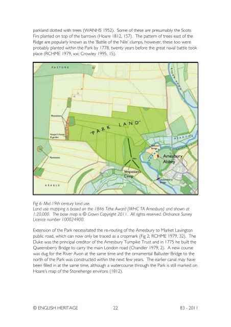
parkland dotted with trees (WANHS 1952). Some of these are presumably the ScotsFirs planted on top of the barrows (Hoare 1812, 157). The pattern of trees east of the<strong>Ridge</strong> are popularly known as the ‘Battle of the Nile’ clumps, however, these too wereprobably planted within the Park by 1778, twenty years before the great naval battle tookplace (RCHME 1979, xxi; Crowley 1995, 15).Fig 6: Mid-19th century land use.Land use mapping is based on the 1846 Tithe Award (WHC TA Amesbury) and shown at1:20,000. The base map is © Crown Copyright 2011. All rights reserved. Ordnance SurveyLicence number 100024900.Extension of the Park necessitated the re-routing of the Amesbury to Market Lavingtonpublic road, which can now only be traced as a cropmark (Fig 2; RCHME 1979, 32). TheDuke was the principal creditor of the Amesbury Turnpike Trust and in 1775 he built theQueensberry Bridge to carry the main London road (Chandler 1979, 2). A new coursewas dug for the River Avon at the same time and the ornamental Balluster Bridge to thenorth of the Park was constructed within the next few years. The earlier canal may havebeen filled in at the same time, although a watercourse through the Park is still marked onHoare’s map of the Stonehenge environs (1812).© ENGLISH HERITAGE 22 83 - 2011