Interior Alaska Revegetation & Erosion Control Guide - Alaska Plant ...
Interior Alaska Revegetation & Erosion Control Guide - Alaska Plant ...
Interior Alaska Revegetation & Erosion Control Guide - Alaska Plant ...
- No tags were found...

Create successful ePaper yourself
Turn your PDF publications into a flip-book with our unique Google optimized e-Paper software.
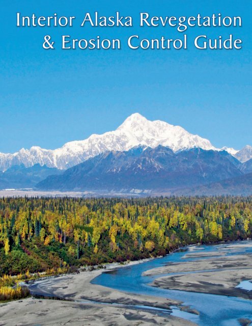
<strong>Interior</strong> <strong>Alaska</strong> <strong>Revegetation</strong>& <strong>Erosion</strong> <strong>Control</strong> <strong>Guide</strong>
<strong>Interior</strong> <strong>Alaska</strong>, for the purposesof this guide, is definedas the 37 USGS quads shownabove. These quads spanseveral unique eco-regions,further detailed on page 49.Front Cover: The Chulitna River meanders in front of the <strong>Alaska</strong> RangeCover Photo: Phil Czapla (AK PMC)
<strong>Interior</strong> <strong>Alaska</strong> <strong>Revegetation</strong>& <strong>Erosion</strong> <strong>Control</strong> <strong>Guide</strong>ByPhilip K. CzaplaandStoney J. WrightEditing | Layout | Design: Brennan Veith Lowi
Any use of trade, firm, or product names is for descriptivepurposes only and does not imply endorsement by any employeeor branch of the State of <strong>Alaska</strong>. Information submitted by privatecompanies in the case studies section of this document is publiclyavailable, and presented for educational purposes. All photographsare copyright of their respective owners.Published July, 2012:State of <strong>Alaska</strong>Department of Natural ResourcesDivision of Agriculture<strong>Alaska</strong> <strong>Plant</strong> Materials Center5310 S. Bodenburg Spur Rd.Palmer, AK 99645This publication was fundedin part by a grant from theUnited States Department ofAgriculture, Natural ResourceConservation Service.<strong>Alaska</strong> <strong>Plant</strong> Materials Center logo: ‘Germinate’ - Original artwork by Sheila Wyne, used with permissionii
Forewordiii
Author’s PrefaceSEAN PARNELL, GOVERNORCENTRAL OFFICE1800 GLENN HIGHWAY, SUITE 12PALMER, ALASKA 99645-6736DEPARTMENT OF NATURAL RESOURCES PHONE: (907) 745-7200FAX: (907) 745-7112DIVISION OF AGRICULTURE XNORTHERN REGION OFFICE1648 S. CUSHMAN ST., # 201FAIRBANKS, ALASKA 99701-6206PHONE: (907) 328-1950FAX: (907) 328-1951XPLANT MATERIALS CENTER5310 S. BODENBURG SPURPALMER, ALASKA 99645-9706PHONE: (907) 745-4469FAX: (907) 746-1568The publishing of the <strong>Interior</strong> <strong>Alaska</strong> <strong>Revegetation</strong> and <strong>Erosion</strong> <strong>Control</strong> <strong>Guide</strong> marks mythirty-third year with the <strong>Alaska</strong> <strong>Plant</strong> Materials Center. Much of the early off-site plot evaluationwork and revegetation studies during my career took place in <strong>Alaska</strong>’s <strong>Interior</strong>. A shift to work oncoastal regions occurred after roughly eight years, in part due to the increasing amount ofconstruction activity in the coastal areas of <strong>Alaska</strong>, and the availability of federal funds for coastalprojects.Another reason revegetation and restoration activities in <strong>Alaska</strong>’s <strong>Interior</strong> subsided was thefact that many disturbances self-restore. On non-fill disturbances, natural revegetation was fastand generally reliable. <strong>Revegetation</strong> in the <strong>Interior</strong> was required only when erosion potential washigh and there was insufficient time to rely on natural revegetation. Highway and airportconstruction activities over the past two decades have kept the <strong>Plant</strong> Materials Center involved inthe other revegetation efforts in the <strong>Interior</strong>.Although the <strong>Interior</strong> allows for greater use of natural revegetation than other areas of<strong>Alaska</strong>, the region is not immune to the problems associated with surface disturbances.Permafrost poses unique and interesting problems when disturbed by construction and mining.The massive forest fires so common in the <strong>Interior</strong> also present water quality issues if erosionoccurs after the fire and before natural revegetation can occur.Working on projects in the <strong>Interior</strong> has left me with a number of great memories ofsuccessful projects and the outstanding summers in the region. <strong>Interior</strong> <strong>Alaska</strong> is a unique place.Hopefully this guide will assist others in their efforts to use vegetation to control erosion problemsand restore disturbed lands to a natural condition.The science of revegetation in <strong>Alaska</strong>’s <strong>Interior</strong> is moving forward in a new direction. Theseeding practice may be different, but erosion control and storm water issues remain importantand must be accommodated during the entire process. This new seeding approach will becautiously introduced so the techniques can be adapted to the rest of <strong>Alaska</strong>, advancing thescience even more. May the effort begin!Stoney J. Wright“Responsibly develop <strong>Alaska</strong>’s resources by making them available formaximum use and benefit consistent with the public interest.”iv
Author’s Prefacev
AcknowledgementsThis guide was written to assist land owners, land managers, engineersand environmental professionals in making decisions regardingrevegetation and the use of vegetation in soil erosion control and soil conservation.The information contained in the guide builds upon past revegetationmanuals including:2001 <strong>Alaska</strong> Highway Drainage Manual - Chapter 16: <strong>Erosion</strong> andSediment <strong>Control</strong>. (2001) State of <strong>Alaska</strong>, Department of Transportationand Public Facilities.Wright, Stoney J. (2008) - A <strong>Revegetation</strong> Manual for <strong>Alaska</strong>. Editedby Peggy Hunt. State of <strong>Alaska</strong>, Department of Natural Resources, Divisionof Agriculture, <strong>Alaska</strong> <strong>Plant</strong> Materials Center.Wright, Stoney J. & Czapla, Philip K. (2011) - <strong>Alaska</strong> Coastal <strong>Revegetation</strong>and <strong>Erosion</strong> <strong>Control</strong> <strong>Guide</strong>, 2 nd Edition. Edited by BrennanVeith Low. State of <strong>Alaska</strong>, Department of Natural Resources, Divisionof Agriculture, <strong>Alaska</strong> <strong>Plant</strong> Materials Center.The authors would like to thank the individuals named below for theirparticipation in this project.Dean Brown with the <strong>Alaska</strong> Department of Natural Resources (DNR),Division of Forestry, Casey Dinkel with the <strong>Alaska</strong> DNR, Division of Agriculture,<strong>Alaska</strong> <strong>Plant</strong> Materials Center, Lee McKinley with the <strong>Alaska</strong> Departmentof Fish & Game and Anne Brown with the <strong>Alaska</strong> DNR, StatePipeline Coordinator’s Office.vi
Table of Contents<strong>Interior</strong> <strong>Alaska</strong> <strong>Revegetation</strong> & <strong>Erosion</strong> <strong>Control</strong> <strong>Guide</strong>Photo: Casey Dinkel (AK PMC)The Trans-<strong>Alaska</strong> Pipeline winds through mixed hardwood and spruce forest in <strong>Interior</strong> <strong>Alaska</strong>.Section 1: BackgroundIntroduction• Geography• History• Impacts• Purpose........................ 2................................................................................................................................................vii
Section 2: Project ImplementationPlanning• Goal Setting & Preparation• Identify Site Conditions• Seeding Methods• Transplanting• <strong>Plant</strong>ing Choices• <strong>Plant</strong>ing Time• Selection of Species• Mulch & <strong>Erosion</strong> MattingTechniques• Charged Overburden Veneer• Sod Clumps• Vegetation Mats• Natural Reinvasion• Enhanced Natural Reinvasion• Imprinting• Scarification• Dormant SeedingWild Seed CollectionPotential Sources of <strong>Erosion</strong>• Wildfire• Agriculture• Transportation• Riverbank <strong>Erosion</strong>• MiningConservation & Protection• Protecting Wetland Areas• Invasive Species• Permafrost Conservation........................6...................................................................................................................................................................................................................................................................................................................... 18............................................................................................................................................................................................................................................................................................................. 32..................... 36.................................................................................................................................................................................................. 42.........................................................................................................viii
Section 3: Species SelectionAdapted <strong>Plant</strong>s• Eco-regions of <strong>Alaska</strong>• Vegetation Communities• <strong>Revegetation</strong> Suggestions<strong>Plant</strong> Species..................... 48.............................................................................................................................. 54Section 4: Case Studies<strong>Revegetation</strong> Projects• True North Mine Reclamation• Chistochina River Wetland Restoration• Kanuti Pit Rehabilitation• Fairbanks Partial Landfill Closure• Riparian Reclamation of Nome Creek• Illinois Creek Mine Site <strong>Revegetation</strong>......................83..................................................................................................................................................................................................................Section 5: Further InformationWorks CitedAppendix A: Seed RegulationsAppendix B: Partner Agencies.....................110........................................................................ix
BackgroundPhoto: Phil Czapla (AK PMC)Section 1:<strong>Interior</strong> <strong>Alaska</strong> is dominated by boreal spruce forests, with wetlands present throughout.The <strong>Alaska</strong> Range is visible in the background of this photo, taken near Talkeetna.Introduction• Geography• History• Impacts• Purpose1
IntroductionPhoto: Brianne Blackburn (AK PMC)Spruce, willow and fireweed are present in this Brooks Range vegetation community.Geography<strong>Interior</strong> <strong>Alaska</strong> is a region defined by three mountain ranges; the BrooksRange to the north, the Chugach to the south, and the <strong>Alaska</strong> Range in between.“[<strong>Interior</strong> <strong>Alaska</strong>] includes North America’s highest mountain, permanently snowcovered peaks, glaciers, rivers and streams, lakes, a diverse geology and vegetationthat ranges from Alpine tundra to boreal forest and wetlands, and a richflora and fauna” (Laursen & Seppelt, 2009).<strong>Alaska</strong> is by far the largest state within the United States of America; havingmore than twice the area of its nearest largest state. Indeed, <strong>Alaska</strong> by itself covers1% of the land mass on Earth, and is larger than all but 19 countries on theplanet. For the purposes of this book, <strong>Interior</strong> <strong>Alaska</strong> is defined by the 37 USGSquadrangle maps included on the inside front cover.2
History<strong>Interior</strong> <strong>Alaska</strong> was first populated by indigenous Athabascan cultures andtribes. The Yukon river and its tributaries provided access and means of travel,communication and trade between peoples. Ancestral peoples followed thespawning salmon into the <strong>Interior</strong>, lived with the seasonal migration patterns ofthe caribou herds, and learned the habits of the moose, bear and other furbearinganimals. Villages and individuals established rights to specific territory, landuse, and water which were generally respected and guarded against foreign encroachment.Almost all villages were occupied in the winter and periodically insummer (Selkregg, 1976).The search for gold in <strong>Alaska</strong> is what gave many <strong>Interior</strong> communities theirstart. Gold was first discovered in Southeast <strong>Alaska</strong> during the 1870s; continuedexploration through the years expanded the findings northwards. Fairbankscame into existence largely due to the discovery of gold in the creeks of Tananahills by Felix Pedro in 1902. Prospectors flocked to the interior with gold fever,hoping to strike it rich. Development soon followed with a trading post and otherbuildings being built to support the new mining district. Today the Fort Knox mine,northeast of Fairbanks produces a large amount of gold.The military presence in interior <strong>Alaska</strong> is significant. Ladd Field, a US AirForce base, was constructed in 1939. It served as a cold weather experimentalstation where soldiers tested clothing and equipment. With the onset of WorldWar II, Ladd Field expanded its role to serve as a transfer station for soviet aircraft.American crews delivered approximately 8,000 aircraft to the Russians fortheir war effort under a lend-lease agreement. Planes were flown from GreatFalls, Montana to Fairbanks. Russians accepted the planes at Ladd Field, thenflew them to Siberia for use in the war effort against Germany (Pike, 2011).In 1961 the Army assumed control of Ladd Air Force Base and renamedthe base Fort Wainwright after General Jonathan Wainwright, a decorated officer.Today Fort Wainwright is home to about 7,700 soldiers. It also encompasses FortGreely and the Donnely Training Area (wainwright.army.mil).Aerial Photo: US ArmyFort Greely is home to the US Army’s largest training area.Fort Greely is a militaryinstallation situated inDelta Junction. This armybase is part of the UnitedStates’s Ballistic MissionDefense Systems (BMDS),charged with destroyingthreat missiles mid-course.Fort Greeley also hosts theCold Regions Test Centerand the Northern WarfareTraining Center. Fort Greelyplays a unique role in theDepartment of Defense,encompassing about 7,200acres of training lands.3
ImpactsImpacts to <strong>Interior</strong> <strong>Alaska</strong> have many causes. The region supports industriesincluding mining, logging, tourism, and oil and gas production. Productionindustries, such as mining, can have significant impacts on the environment, andthese effects must be mitigated. Mining, road-building, and tourism all take atoll on the natural environment. Human-caused impacts such as these havedisrupted natural ecosystems and resulted in significant changes. Proper stewardshipdictates that these human-caused impacts to <strong>Interior</strong> <strong>Alaska</strong>’s ecosystembe minimized.PurposeThis guide was developed to aid in the process of revegetation. The intendedaudience is private property owners, local and government agencies,environmental engineers, resource extraction companies, and anyone else thatmay encounter a need for erosion control or revegetation.For the purpose of this document, revegetation is defined as:The re-establishment of plant cover by means of seeding or transplantingon a site disturbed by natural or man-caused actions.Impacts, both large and small, will continue to disrupt interior <strong>Alaska</strong>. Recovery(defined as the presence of self-sustaining vegetative cover and limitederosion) of most sites can be expedited and impacts minimized with human interventionto correct limitations and guide the ecosystem towards a desired endstate. Material presented in the manual focuses on the “soft approach” to erosioncontrol, using vegetation as opposed to the “hard approach” which utilizes engineeredstructures.Numerous methods for reintroducing vegetation on a site are available.This manual details a logical sequence of surface preparation, fertilization, andseeding. When followed on a project site, this sequence will usually result in aself-sustaining native plant community that requires minimal management input.When conditions allow, most disturbed sites will naturally be re-colonizedwith plants from the surrounding area, though it may take several years before aplant community becomes established. Natural reinvasion, as this technique isknown, is at times used in <strong>Interior</strong> <strong>Alaska</strong>. This approach tends to be more acceptablein areas that are not highly visible and do not have immediate erosioncontrol needs or regulatory time lines.The latter portion of this manual is dedicated to case studies, highlightingpast revegetation projects that have occurred throughout <strong>Interior</strong> <strong>Alaska</strong>. Theseprojects expose the realities of revegetation in the field, including successes,challenges, and lessons learned. It is our hope that these case studies will becomea useful resource for future projects. These reports, as well as case studiesfrom the <strong>Alaska</strong> Coastal <strong>Revegetation</strong> & <strong>Erosion</strong> <strong>Control</strong> <strong>Guide</strong> are availablefrom the <strong>Alaska</strong> <strong>Plant</strong> Materials Center’s website, at plants.alaska.gov/reveg.4
Project ImplementationPhoto: Will Menheere (Fairbanks Gold Mining Inc. )Photo: Phil Czapla (AK PMC)Section 2:A well prepared seedbed along the slope contour creates an ideal environment for seed germination,while the furrows limit down-slope water flow.Planning• Goal Setting & Preparation• Identify Site Conditions• Seeding Methods• Transplanting• <strong>Plant</strong>ing Choices• <strong>Plant</strong>ing Time• Selection of Species• Mulch & <strong>Erosion</strong> MattingTechniques• Charged Overburden Veneer• Sod Clumps• Vegetation Mats• Natural Reinvasion• Enhanced Natural Reinvasion• Imprinting• Scarification• Dormant SeedingWild Seed CollectionPotential Sources of <strong>Erosion</strong>• Wildfire• Agriculture• Transportation• Riverbank <strong>Erosion</strong>• MiningConservation and Protection• Protecting Wetland Areas• Invasive <strong>Plant</strong>s• Permafrost Conservation5
PlanningPhoto: Gordy Schlosser (Great Northwest Inc.)Emergent grass species are evident on this reclaimed landfill a few weeks after seeding.Planning should be the first step for any project. The revegetation/restoration process requires careful planning and management, as the designeris working with biological processes that have specific timing and environmentalrequirements. When multiple stakeholders are involved in a restoration project,design decisions should be coordinated. This allows restoration goals to beimplemented effectively.Goal-Setting & PreparationThe planning phase of a restoration project encompasses several steps.These include:• Gathering baseline data,• Identifying site problems,• Collecting reference plot information, and• Setting goals.Goals tell managers about the desired state of the ecosystem, as comparedto a reference ecosystem. Objectives are measures taken to attain the goals,and are evaluated on the basis of performance standards (SER 2002). Withoutclear goals, objectives and performance standards, a restoration project shouldnot move forward.6
Performance standards come from an understandingof the reference ecosystem and therealization that the trajectory of the degraded siteshould progress towards the desired state of recoverycomparative to the reference site.If data collected and interpreted duringmonitoring shows that performance standardshave been met, then project objectives have beenreached. <strong>Revegetation</strong> goals may include erosioncontrol, visual enhancement, weed control, orother desired outcomes. Often the goal is erosioncontrol.Baseline Environmental Data CollectionAfter determining the revegetation objectives,take note of factors influencing the site.These include climate, soils, topography and vegetation.Climate includes temperature, precipitation,and wind, as well as other factors. Climaterecords can be obtained online, through resourcessuch as the National Oceanographic and AtmosphericAdministration’s National Climate DataCenter, at ncdc.noaa.gov.A soils inventory involves identification ofsoil types and characterization of the soil types,as well as distribution. Soil surveys have beencompleted by the Natural Resource ConservationService (NRCS) and are accessible online at soils.usda.gov. If feasible, a sample of soil from the siteshould be sent to a soil testing lab. There, a labanalysis will check the physical (texture, density),chemical (pH, salts, organic matter) and biotic (activitiesof organisms) characteristics of the soil. Allof this information aids in developing a seed andfertilizer mix.Mapping of vegetation types and characterizationof the vegetation types in regards toproduction, cover and density will be part of anin-depth vegetation analysis. Review available regionaldata prior to creating a revegetation plan.Reference SitesA reference ecosystem serves as a modelfor planning a revegetation/restoration project, allowingfor measurement of the progression of anecosystem towards its desired end-state (SER,2002). It’s important to note that a restored ecosystemcan never be identical to the reference. Areference system is best assembled from multiplereference sites to account for the possibility thatone particular site may be biased.Many sources of information are useful indescribing a reference site, such as lists of speciespresent, maps of the site prior to damage,and aerial and ground-level photography (SER,2002). Reference ecosystems should have highproduction and species composition in order formanagers to evaluate the progress of the ecosystemstowards its desired state of recovery. Eventuallythe restored ecosystem should emulate orclosely resemble the attributes of the referencesite (SER, 2002).Collecting information from a referencesite can be costly, and is often limited by availablefunds.PermittingPermits may be required for some projects.Regulations are always changing, however,so consult appropriate agencies to make sure thatyou have any permits necessary. A list of agenciesis included as Appendix B.Projects that disturb an acre or more, dischargestorm water into a municipal separatestorm sewer system (MS4), or into the surfacewaters of the United States require an <strong>Alaska</strong>Pollutant Discharge Elimination System Permit(APDES). This permit is issued by the <strong>Alaska</strong> Departmentof Environmental Conservation (DEC),in accordance with the Federal Clean Water Act.APDES permits are issued as either a phase oneor phase two permit depending on the size of thearea disturbed and nearby population. More informationabout the APDES program can be found atthe DEC website, at dec.state.ak.us/water/npdes.A dewatering permit is necessary if the totaldischarge volume is equal to or greater than250,000 gallons and wastewater discharge islocated less than one mile from a contaminatedsite. Other permits are necessary for projects thataffect fish habitat, historic properties, endangeredspecies, and other concerns. The regulationsabove were those in force at the time of printing.Please be aware of current regulations before beginninga project.7
10semi-arid climates. Acidicsoils are formed in wetterclimates where the baseshave been leached throughthe soil profile. Having anidea of the pH value of thesoil will help with plant selection,as some speciesprefer more acid soils andothers prefer more alkalinesoils. To correct acidic (lowpH) soils a limestone applicationis used, and to mitigateoverly basic (high pH)soils, sulfur is applied.Electrical ConductivityThe electrical conductivityof a soil is determinedby the amount of solublesalts in the soil. <strong>Plant</strong>s growbest when the electrical conductivity(amount of salt) ofa soil is low. Almost all plantspecies are endangered byhigh salt levels, particularlyyoung seedlings. High saltconcentrations can be foundin arid climates where thereis not enough rainfall to leach salts out of the plantroot zone. Incorporating Gypsum into the soil mayhelp to correct this.Organic MatterA portable pH / ElectricalConductivity meteris used to identify siteconditions in the fieldFertilizer should be selected based on soiltests and the needs of the vegetation to be planted.Fertilizer is described using the percentagesof three macro-nutrient elements: nitrogen (N),phosphorus (P), and potassium (K). For example,20-20-10 fertilizer contains 20% nitrogen, 20%phosphorus, and 10% potassium by weight.If possible, fertilizer should be applied concurrentwith or prior to seeding. Once the seedhas been applied no additional traffic should beallowed on the site. This is to avoid compactionand unnecessary disturbance of the seed bed.TopsoilThe topsoil layer in undisturbed areas in<strong>Alaska</strong> is often very thin, and therefore expensiveand impractical to salvage. However, this layer isa source of native seed, plant propagules, organicmatter, and soil microbes which can enhance thequality of the substrate being revegetated.Topsoils tend to have lower salt contentthan subsoils. When topsoil is removed duringconstruction, the remaining soils can be very highin salts and pH (Steinfeld et al., 2007). Topsoil is avaluable resource in revegetation, and should besalvaged when possible.Many construction sites in <strong>Alaska</strong> have exposedsurfaces of gravel or gravely soils. Gravellysites tend not to be highly erodible. If some fineparticles are present in the gravelly soil, adaptedspecies will grow without additional topsoil. Infact, the addition of a layer of topsoil on a gravelsurface can increase erosion potential.Organic matter consists of partially decayedand decomposed plant and animal matter, suchas roots, branches, needles, bark and Influence of pH on Availability of <strong>Plant</strong> Nutrientsinsects. In general, organic materialmakes up from 1 to 6% of the soil andis very important for water and nutrientretention. <strong>Revegetation</strong> potential ishigher in soils with more organic matter.NutrientsIn most forms of revegetation, applicationof fertilizer at the time of seedingis necessary. Most commercialfertilizers meet minimum standards forquality. When problems do arise, theycan usually be traced to the product becomingwet during storage or shipment.PHOTO: Brennan V. Low (AK PMC)GRAPHIC: S.S.S.A.P, 1946 11:305, Redrawn by K. Williams; extension.org
Construction Site ConsiderationsConstruction and mining sites rarely haveintact soil horizons. The preceding discussion onsoil profiles does not apply to most disturbed land.More basic measures of soil particle size, elasticity,and water holding capacity are usually appliedto construction and mining sites. The uniform soilclassification table is the best means of determiningsoil characteristics for revegetation purposes.The Unified Soil Classification System(chart included below) describes both the textureand grain size of a soil. Symbols are composed oftwo letters; the first represents primary grain sizedivision (>50% of soil). The second letter refers tothe uniformity or plasticity of a soil, or to a secondmajor soil type (>12% fines present).Seeding MethodsThe objective of seeding is to place the seedwhere it is needed and in proper contact with thesoil. The method used depends upon the plant speciesbeing seeded, equipment availability and sitecharacteristics such as soil type and topography.Drill SeedingDrill seeding is a method whereby the seedis placed in a soil furrow and covered with a relativelyprecise amount of soil. Drill seeders areused most often in agricultural settings. One typeof drill seeder, the Brillion-style, is often used forrevegetation of mine and construction sites. Thisseeder has been successfully used on most soiltypes, except very gravelly soils.Fertilizer cannot be applied with all drillseeders, however, the drill seeder delivers theseed into the soil, packs the seed in place, andapplies seed with high accuracy. This method isconsidered by many to be the best method of distributingseed, however the need for specializedequipment may be impractical at many sites in<strong>Alaska</strong>.Broadcast SeedingThe broadcast method scatters seed onthe soil surface and relies on natural processes orharrowing to cover the seed. The recommendedseeding rate for broadcasting is double that ofdrilling due to the lack of application control, seedChart: American Society for Testing & Materials D 2487-83Coarse grained soils- more than 50%retained on No. 200(0.075 mm) sieveFine grained soils- more than 50%passes No.200 sieveMajor Divisions Group Symbol Group Namegravel > 50% of coarsefraction retained onNo. 4 (4.75 mm) sievesand ≥ 50% of coarsefraction passes No.4sievesilt and clayliquid limit < 50silt and clayliquid limit ≥ 50clean gravel 12% finesclean sandsand with >12% finesinorganicorganicinorganicorganic clay,organicOHorganic siltHighly organic soils Pt peatUnified Soil Classification System (USCS)GWGPGMGCSWSPSMSCMLCLOLMHCHwell graded gravel,fine to coarse gravelpoorly graded gravelsilty gravelclayey gravelwell graded sand,fine to coarse sandpoorly-graded sandsilty sandclayey sandsiltclayorganic silt,organic claysilt of high plasticity,elastic siltclay of high plasticity,fat clay11
1. Be free of construction debris;2. Have relatively few large rocks or objects;3. Be free of ruts and gullies;Broadcasting includes aerial seeding, hydroseeding,and hand-held methods. Hand-held andhand-operated spreaders are used due to theirportability, increased speed, lower costs, and suitabilityto both seed and fertilizer application.HydroseedingHydroseeders are well suited for seedingsteep slopes and rocky areas, as they apply mulch,seed, and fertilizer in a single step. Hydroseederscome in truck-mounted and trailer forms. Majorcontractors either have a hydroseeder or can easilysubcontract one.An Ideal Seedbed Should :4. Have the top two inches in a thoroughly tilled, friable, non-compacted condition (allowing a 170pound person heel print to make a ¼ to ½ inch impression);5. Be scarified to a depth of 6 to 8 inches, if soil is heavily compacted;6. Devoid of non-native established weeds. Competition from weeds is can be a cause of seedingfailure; and7. Without a significant seed-bank of weedy species. Seed stored in the soil as hard or dormant seedmay be viable and will germinate if the conditions are right. The presence of a nearby seed-bankoften accounts for the surprise of a weedy species showing up on a site.predation, and potential reduction in seed establishmentand germination.Hydroseeder manufacturers have claimedthat hydroseeding promotes vigorous plantgrowth. Grass growth can be inhibited, however, iftoo much mulch is applied.Hydroseeding has also been portrayedas the most effective means for revegetating anarea, though this claim is debated. The primarydisadvantage of hydroseeding is the requirementfor large quantities of water, which can result innumerous passes across the land that is beingrevegetated. The equipment is also complex, andmechanical problems can cause costly delays.Hydroseeders are also useful as supplementalwatering trucks once seed has been applied.Additional water applications increase projectcosts and are not always necessary to producePhoto: Casey Dinkel (AK PMC)Photo: Brennan V. Low (AK PMC)12A drill seeder, in this case a Brillion ©, is often used for planting revegetationspecies. The large drum in the background is an imprinter, used tofirm the seedbed as well as create furrows into which the seed will settle.A drill seeder drops seed into arow prepared by the spinning discs.
Photo: Gary Antoni (AK PMC)a good stand of vegetation. Even without additionalwater application, seed will remain dormant untilrainfall provides sufficient moisture for germination.A hydroseeding contract should state thatseed will not remain in the hydroseeder for morethan one hour. This will prevent seed from absorbingexcess water and being damaged by the dissolvedfertilizer.Aerial SeedingAerial seeding uses an aircraft to place seedand fertilizer onto a site. This method is used to:1. Broadcast seed over very large areas(50+ acres),2. Apply seed rapidly to an area,3. Apply seed in remote locations inaccessibleto other seeding equipment.Aerial seeding is used often after wildfires tostabilize slopes quickly and prevent erosion.Seeding RatesThe revegetation suggestion chart on page52 lists broadcast seeding rates for revegetationspecies. In this publication, hydroseeding is consideredbroadcast seeding with regard to seedingrates. Note that the rates provided should behalved when drill seeding.Site PreparationSeedbed preparation is the primary concernof most revegetation projects, since it is themost labor-intensive, energy consumptive, andoften determines success or failure (Vallentine,1989). The objectives of site preparation are tocreate several safe sites or micro-environmentsthat provide favorable conditions for seed germinationand seedling growth.The surface of the prepared seedbedshould be relatively smooth for drilling and roughfor broadcasting. Germination and survival increasewith proper site preparation.If traditional surface preparation equipmentsuch as disks and/or chisel plows are available,the conditions required for adequate surfacepreparation are the same as previously noted.Note: If hydroseeding is chosen as a method of seedapplication, surface preparation as described in thissection may not be applicable.Photo: Glenn Air / Northern Reclamation ServicesHydroseeding is used to revegetate slopes that are not easilyaccessed by traditional seeding equipmentAerial seeding can be used forrevegetating large, linear or remote sites.13
TransplantingTransplants, cuttings, and sprigs are all aform of planting where some portion of a live plantis placed directly into the soil. This is a labor intensiveprocess; however there are times whenit is the most appropriate revegetation method.<strong>Plant</strong>ing transplants, sprigs or cuttings is a way tojump-start vegetation growth, as the transplantedspecies has already reached a certain state of development.<strong>Plant</strong>ing ChoicesAfter a species or species mixture has beenselected, a decision needs to be made about whichform of plant to use. Cost, revegetation objectivesand availability of equipment are a few of the factorsthat influence this decision (Whisenant, 2005).SeedSeed is commonly used for revegetating disturbedareas. Seed is easy to collect, clean, store,transport, mix and apply to a site by drill or broadcastmethods. Grass and forb species are usuallydirectly seeded onto disturbed sites.Seed SpecificationsQuality seed is a critical component to success.Specifying “certified” seed assures qualitygermination and purity; certification also providessome assurance of genetic quality.Some native seed species are not availableas certified seed. Seed quality can still be ascertainedby examining percent germination and percentpurity; information that will be clearly labeledfor any seed sold in <strong>Alaska</strong>. This labeling is requiredby 11 AAC, chapter 34: Seed Regulations(included as Appendix A).The true cost of seed can be determinedby the Pure Live Seed calculation. To calculatePure Live Seed (PLS), use the following equation:The true price of seed, then, can be determinedusing the equation below:These calculations can increase the accuracyof bid comparisons. PLS price is a goodmethod of comparing different seed lots at purchase.All seed sold or used in the state of <strong>Alaska</strong>must also be free of noxious weeds (11 AAC34.075). This is noted on seed tags, along withgermination and purity.Seed stored on site should be kept cool,dry, and in rodent-free areas. Remember seed isa living commodity; always buy seed based on thePLS calculation.Certified SeedThe term “certified seed” can cause confusionbecause it is used to describe two conditions:The official use of the term Certified seed(with a capital C) is to describe seed grown underthe rules of the Seed Certification Program. Itsancestry can be traced back to Registered Classor Foundation Class seed. In addition, the Certifiedseed must meet standards of purity and germination.These standards are a means of verifyingauthenticity of a seed source. All the <strong>Alaska</strong>developed seed varieties or cultivars can be soldas either Certified or common.Seed can also be certified (without a capitalC) to be free of weeds or as meeting a minimumgermination standard (11 AAC 34.075). Thishas nothing to do with variety identification - itsimply indicatesthe quality of theseed.14<strong>Alaska</strong> Certified seed tagsPre-certified Class seed tags
Seed produced in <strong>Alaska</strong> is easy to traceto its origin. It may be common (uncertified) ‘Arctared’,but it is still ‘Arctared’. Minimum puritiesand germination should always be stated with orders.Certified seed should be used when available,although common seed is a usable productand may also be used to meet demands.Common seed should meet Certified standardswith regard to germination and purity, althoughthese standards may need to be relaxed toacquire sufficient material for a large job. Lowergermination rates can be overcome by increasingthe seeding rate. Avoid lower purities of seed.Other Certification ClassesMany new native seed sources are beingdeveloped in <strong>Alaska</strong>. For the most part, these willnot be sold as Certified seed. They may carry thefollowing designations: Source Identified, TestedClass, or Selected Class. These classes willbe in keeping with the standards of germinationand purity of the Certification system, but the termCertified seed will not apply. These classes arereferred to as being Pre-certified Class.TransplantsTransplants are plants that were/are growingin their native habitat and are transplanted directlyinto a restoration site or nursery to be cultured forfuture use. Large transplants provide visual prominenceto a site and have the ability to establishand spread quickly (Hoag, 2003).Transplanting shock is a problematic and commonoccurrence, whereby the transplanted speciesfails to become established. Care should beexercised and appropriate horticultural practicesused to prevent transplant shock.SprigsSprigging is a method of transplantingwhereby a plant clump is divided into individualsprigs, each of which is capable of growing into anew plant. Sprigs can be harvested from wildstands of vegetation, and planted without specialequipment. A sprig does not need to have well-developedroots at planting time, only a portion of thebelow ground crown. The above ground portion ofa sprig may die back after transplanting, howeverthis is not cause for concern. New growth willstart from the below ground portion. Sprigs becomeestablished faster than seeded grass.Bare-root stockBare–root stock is commonly used to establishwoody plants. Seedlings are grown in outdoornurseries, lifted from the soil when dormant,and then stored in a cool and moist environmentuntil transplanted (Munshower, 1994). Hardening,which induces dormancy, is often done in a6-8 week period prior to transplanting, in order toacclimate the seedlings to their new environment.Container-grown stockContainer stock is grown in artificial growingmedia in a controlled environment, usually agreenhouse. When harvested, the root systemforms a cohesive plug (Steinfeld, 2007). Containerscome in a variety of sizes and shapes. Container-grownplants are able to tolerate harsherconditions more easily than bare-root transplants(Eliason & Allen, 1997).CuttingsThe use of willow cuttings is the most commonused method of vegetative planting in <strong>Alaska</strong>,both historically and today. The use of willow cuttingshas proven successful in all areas of <strong>Alaska</strong>where willow occurs naturally. Because timing iscritical to both collection and planting, prior planningis an absolute necessity.For detailed instructions on the use of willowcuttings, please refer to Streambank <strong>Revegetation</strong>and Protection, a guide published by the<strong>Alaska</strong> Department of Fish & Game. This publicationcan be found online, at www.adfg.alaska.gov/index.cfm?adfg=streambankprotection.main.Willow stakes, planted while dormant,will grow again in the spring.Photo: Andy Nolen (AK PMC)15
<strong>Plant</strong>ing TimeTiming is crucial to revegetation success.The optimum planting season is just before thelongest period of favorable conditions. Springplanting is ideal where the primary growing seasonoccurs in the late spring and/or summer. Theend of the planting season for <strong>Interior</strong> <strong>Alaska</strong> generallyfalls between August 15 th and 31 st .If you are planning a revegetation projectafter the end of the planting season, refer to thedormant seeding section of the Techniques chapterfor further information.Selection of SpeciesAfter receiving a project contract, assess theavailability of potential species. If seed and plantmaterials are available at the correct time and anacceptable cost, the purchase should be madeimmediately. Buying seed early ensures that theproduct will be available as needed. Care needsto be taken to assure the seed and plant materialsare properly stored in a dry, cool environment toprevent loss of viability.One of the most important criteria for successfulrevegetation is species selection. A restorationproject seldom relies on a single species,however.A classic definition states:“Species selection strategies that emphasizediversity assume species-rich ecosystems are morestable and less susceptible to damage from unusualclimactic events, disease or insects” (Whisenant,2005).Several characteristics are important inchoosing a seed mixture, including: reliable establishment,ability to survive changing conditions,and ease of propagation (Coppin & Stiles, 1995).The <strong>Alaska</strong> <strong>Plant</strong> Materials Center recommendsincluding at least three species in a planting mixture.<strong>Plant</strong> species should be chosen based ontheir adaptation to the project site and whether ornot it is native to the area being revegetated.Species is Adapted to siteThe harsh environments of <strong>Alaska</strong> limitspecies growth and production potentials. Therefore,it is imperative that species chosen are ableto survive and thrive in the local environment. Climatic,topographic, and soil conditions all influenceplant performance, and should all be takeninto account when selecting species.Species is Native to the areaNative species, already adapted to <strong>Alaska</strong>,generally perform better than introduced materials.However, prices may be higher for nativeplants or seed. Availability is currently the primaryobstacle to using native species in <strong>Alaska</strong>,although in-state production is increasing, due inpart to state and federal mandates requiring theuse of these species.A list of commercially available native plantspecies is available in the Native <strong>Plant</strong> Directory,Photo: Brennan Low (AK PMC)Seeding should be accomplished using high quality seed that has been properly stored and is free of weeds.16
which can be found at the <strong>Alaska</strong> <strong>Plant</strong> MaterialsCenter website, at plants.alaska.gov/native.A discussion of non-native and invasive plantscan be found in the Conservation and Protectionchapter, on page 43.Mulch and <strong>Erosion</strong> MattingIf soil has a high erosion potential, considerationshould be given to using a soil cover suchas mulch or erosion matting. Using a soil covercan conserve soil moisture, moderate soil surfacetemperature and increase germination. When decidinga soil cover method to use (i.e. mulch orerosion matting), several factors should be considered.<strong>Erosion</strong> potential due to wind or water isthe first and primary consideration.If the soil does not have a high erosion potential,then mulch and/or matting may be skipped.The second consideration is cost. Application ofmulch and matting add significant costs to a project;not only in materials, but also in labor. An additionalconsideration is that straw may introduceunwanted weeds.The above concerns do not apply to woodand paper fiber or similar products used in hydroseeders.When hydroseeders are used, mulch isobligatory. The mulch fiber forms a slurry that actsGeotextile fabric is a popular and effective type oferosion control matting. It is both inexpensiveand resistant to weather extremes.as a carrier for the seed and fertilizer. Withoutmulch, seed and fertilizer would not suspend properlyor efficiently in solution, and uniform distributionwould be impossible. Mulch also serves as avisual indicator of areas that have been treated.Photo: Phil Czapla (AK PMC)Seeded grasses become established through jute erosion control mattingPhoto: Sam Lamont (AK DOT&PF)17
TechniquesPhoto: Don RossMany techniques exist for revegetation, including pre-prepared vegetation matsIn a number of situations, revegetation through seeding is not practical.There are several alternative methods that can be used to revegetate an area, inplace of seeding. The different approaches highlighted in this chapter provide forgreater flexibility to various site conditions and available materials.18
Charged Overburden Veneer:This technique promotes growth by spreading overburden (usually topsoiltaken from a nearby work site) over an area to be revegetated. Seed, roots,nutrients, and microorganisms already present in the soil constitute the ‘charge’,and are relied upon to establish vegetation. The drawback to this revegetationtechnique is that it may involve placing an erodible material on the site.An additional step to this revegetation approach consists of pushing thevegetative cover aside into debris piles, and then removing the topsoil layer andsetting it aside as well. Upon completion of excavation, the site is re-contouredand the topsoil and vegetative debris is spread back over the area. The vegetativedebris and ‘charged’ topsoil promote the growth of vegetation and increase thelikelihood of a successful revegetation outcome.Special measures must be taken if the overburden material has the potentialto be transported into storm sewer systems and / or surface waters. NumerousBest Management Practices (BMPs) exist to limit soil sediment transport. Formore information, view Appendix F of the <strong>Alaska</strong> Storm Water Pollution PreventionPlan <strong>Guide</strong>, available at www.dot.alaska.gov/stwddes/dcspubs/manuals.shtml.Photo: Steve McGroarty (AK DOT&PF)Vegetative debris was spread over a re-contoured waste rock dump at the Illinois Creek Gold Mine.19
Topsoil being gathered onsite - November, 2005Spreading charged overburden - May, 2006Heavy equipment used to spread topsoil - May, 2006Photos: James Bowers (AK DOT&PF)Vegetation growth after 2 seasons - August, 2008Vegetation cover fully established, using charged overburden technique - August, 200820
Sod Clumps:The use of sod clumps is a form of transplanting whereby natural vegetationstands are harvested in block form. Dimensions of these blocks vary from one toseveral feet square (Muhlberg & Moore, 1998). Using sod clumps provides immediatevegetative cover on a site, and species are able to establish on a large areamore quickly than with other forms of transplanting (i.e. using sprigs or individualplants).Transplanted tundra plugsPhotos: AK DEC, Spill Prevention and ResponseHarvesting sod clumpsusing a BobcatPlacement of sod clumpsPhoto: Nancy Moore (AK PMC)A prepared grass roll, consisting of sod clumps wrapped in abiodegradable fabric, with slits cut in the top for the shootsSod clumps are also used in therestoration of erodible stream banks.Grass rolls use sod clumps wrapped inbiodegradable fabric to stabilize riverbanks and quickly establish vegetationcover. For further explanation ofthis technique, refer to the ADF&Gpublication: ‘Streambank Vegetationand Protection, a <strong>Guide</strong> for <strong>Alaska</strong>’,or visit www.adfg.alaska.gov/index.cfm?adfg=streambankprotection.main.21
Vegetation Mats:If clumps of sod are not readily available, a vegetative mat can be preparedin a nursery or greenhouse, and later transported to the site. In this technique,plantings are grown in a controlled environment until roots and rhizomes haveestablished.Vegetation mats provide many of the same benefits of a sod clump, howeverat a greater cost in time, materials and labor. Prior planning is necessarywhen using vegetation mats, as the preparation of a mat will take at least onegrowing season. Some seeds may require stratification, while others may requirescarification. All of these factors should be taken into account if you are using thistechnique.Photos: Peggy Hunt (AK PMC)Soil spread on erosion control fabric provides a binding medium for roots.10’ x 3’ constructed mats framed with dimensional lumber, with thick plastic and erosion control matting usedfor the base. Only the biodegradable erosion control matting will remain once the mat is deployed.22
Stratified seeds are sown on a vegetation mat, using hand seeders and aconstructed grid to seed at a rate of 1 seed per 2 inch square.Photo: Peggy Hunt (AK PMC)Photo: Peggy Hunt (AK PMC)Photo: Peggy Hunt (AK PMC)In situ irrigation allows wetland species tothrive in the constructed vegetation mat.Germinated seeds take root in the constructed vegetation matsPhoto: Don RossPhoto: Don RossUnderside of vegetation mat,showing developed roots intertwinedwith erosion control fabricEstablished water sedge mats, ready for transport to site23
Vegetation mats should be sized to fit available methods of transportation.Heavy plastic sheeting facilitates on-sitetransport of the vegetation mats.A line of vegetation mats, ready for placementPhotos: Don Ross24Vegetation mats being installed along the waters edgeVegetation mats, one year after transplanting
Natural Reinvasion:This technique relies on natural processes to revegetate a site. It is a slowprocess with unpredictable results. Management is not required because neitherseedbed preparation nor planting is done. Species from the surrounding areasarrive through natural processes, usually by wind dispersal. Though it may takemany years for a plant community to become established, this method can behighly effective and is often used at sites that are out of view. When communitiesare concerned with initial aesthetic and visual appeal, or a regulatory timeline applies,this technique should be avoided.Photo: Steve McGroarty (AK DOT&PF)Natural invasion is evident at this materials borrow site, four years after the closure of the IllinoisCreek Gold Mine. The borrow site is being colonized nicely by species from the surrounding area.25
Enhanced Natural Reinvasion:Natural reinvasion can be assisted or enhanced with any combination ofsurface preparation or modification techniques, fertilizers, and soil amendments.This technique is infrequently used in the field, as few sites offer ideal conditions.Additionally, the regulatory process precludes methods that cannot give specificsof final vegetative cover and/or composition.The enhanced natural reinvasion method of revegetation is dependent uponseed to arrive at the site by natural processes. This method is faster than naturalreinvasion, but still has a relatively low success rate. Anyone wishing to apply thistechnique must understand the potential for failure and be willing to move to anactive form of revegetation if the process does not perform well or other problemsemerge.Photo: Phil Czapla (AK PMC)Using a tow-behind broadcast seeder to apply fertilizer can ensure uniform distribution.Photo: Stoney Wright (AK PMC)Photo: Stoney Wright (AK PMC)The effect of surface scarification on plantestablishment and growth after two growingseasons. No seed was applied to the site, but itwas fertilized with 20N-20P-10K at a rate of500 pounds per acre.Fertilizer should be applied to edge of existing vegetation.26
Imprinting:Land imprinting is a method of seedbed preparation that uses heavy rollersto make a depression in the soil surface, creating basins in the soil that reduceerosion, increase water infiltration and captures runoff (Dixon, 1990). Imprintingcan be accomplished with heavy equipment such as a compactor with a ‘sheepsfoot’attachment. A broadcast seeder is often attached to the back of an imprinterto apply seed.When the soil has been imprinted, uncovered seeds in the basin areas willtend to be covered by natural processes such as wind and rain. Imprinting createsmicro-climates suitable for plant germination and growth. ‘Track-walking’ is amethod of imprinting whereby the cleats on a tracked vehicle leave depressions ona soil surface. This technique is commonly used on sloping sites, before seeding.The equipment should be operated so as to leave depressions that will interceptrunnoff as it flows downslope. When using the track-walking technique, the surfacearea of the treated site is increased by approximately 20%; application ratesof materials should be adjusted accordingly.Photo: Stoney Wright (AK PMC)Photo: Gordon Scholsser (Great Northwest, Inc)The wheels of this landfill compactor imprint the surface area,creating basins of micro relief in the seedbedPhoto: Stoney Wright (AK PMC)If operating on a slope, tracked vehicles shouldbe driven up and down to the slope such thatthe cleat marks left after track-walking areroughly perpendicular to the slopeImprinting creates pockets in the soil, each with afavorable micro-climate for vegetation growth27
Photo: Phil Czapla (AK PMC)Photo: Stoney Wright (AK PMC)Surface imprinting accomplished usingthe ‘track-walking’ technique.Vegetation grows first in the depressions created by thecleats of a tracked vehicle.Photo: Stoney Wright (AK PMC)Puccinellia nutkaensis grows in the depressions created by bulldozer tracks.28
Scarification:Soil is scarified on almost all sites in preparation for seeding and fertilizer.A harrow is a tool used to roughen the soil surface and kill shallow-rootedweeds. This process, called ‘harrowing’, may also break the compaction layerwithin the first few inches of the surface. When used after broadcast seeding aharrow will help to cover the seed with soil.Heavy equipment, such as graders and front-end loaders, are frequentlyused for scarification on highly compacted rocky soils. A dozer blade can be modifiedwith ‘tiger teeth’ at regular intervals and used for scarifcation.Photos: Stoney Wright (AK PMC)Deep scarification of the soilsurface can be accomplishedusing a grader with a ‘rippershanks’ tool bar.A bulldozer, modified with ‘Tiger-Teeth’ attached to the blade, is an effective means ofsurface modification that promotes root growth by reducing soil compaction .29
Dormant seeding is the process of planting seed during late fall or earlywinter when soil temperatures are too cold for seed germination to occur; so thatseed germination occurs the following spring.Facts to consider when choosing Dormant Seeding:Choosing dormant seeding as a revegetation approach will allow for anextended planting season. The planting window for revegetation projects can beextended by several months when the dormant seeding method is part of a revegetationplan.Seeds in flats for cold / moist stratification over the winter.During the stratification process, seeds are placed in cloth bags,with a layer of peat beneath and above them. The cloth aroundthe seeds provide a steady source of moisture.Dormant Seeding:Photo: Don Ross<strong>Plant</strong>ing seed later in the seasoncan naturally overcome seed dormancymechanisms. Some native speciesrequire exposure to cold and moisture(overwintering) to break internal andexternal dormancy. In these species,the winter season allows for stratificationand scarification processes to takeplace. Breaking seed dormancy in aspring/summer planting schedule mayrequire that these winter conditionsbe artificially recreated in a controlledenvironment. Most grasses used forrevegetation in <strong>Alaska</strong> do not requirethis treatment. Forbs are more likely torequire stratification.Another benefit of dormant seeding is the head-start it provides againstweeds. Seed present in the soil at the start of the growing season will face lesscompetition from weeds for resources like oxygen and water.Dormant seeding can also result in significant and unanticipated problems.Unseasonably warm temperatures after seed placement can trigger germination,and the possible failure of the seeding effort due to seedling mortality. Also, seedpredation by rodents or birds can become a concern if seed was not adequatelyprotected. Seed can also be transported away from the intended site by wind duringthe winter, or by water erosion during spring break-up.Remember that dormant seeding cannot be counted as an active measureon the Storm Water Pollution Prevention Plan (SWPPP) without some other physicalmeasure that protects the soil surface overtop of the seed bed. Dormant seedingis not an immediately effective Best Management Practice (BMP).30
Dormant seeding is a rollof the dice and requires ahigh degree of confidence.The user is essentially becominga farmer.Site Preparation & <strong>Plant</strong>ingSeeding methods become more limited with dormant seeding. The groundshould be frozen with a soil temperature below 40 degrees so that the seed willnot germinate. Seeds must remain un-germinated and in place until after the nextgrowing season starts.Late season planting restricts the type of site preparation equipmentthat can be used, as well as the method used to apply the seedmix. Frozen soil on a project site is harder to manipulate, and this canaffect the viability of the seedbed. A mechanical implement such as adrill seeder is not as adaptable to frozen soil. Broadcasting and hydroseedingare effective methods for distributing seed on frozen ground.If hydroseeding, a dark colored mulch should not be used in the slurry.Dark mulches may raise the soil temperature promoting early germination.<strong>Plant</strong>ing Time & RateAs a general rule dormant seeding should only be undertakenafter the first hard killing frost, but not after four inches of snow. Thiswill prevent premature germination and allow good seed-to-soil contact. Dormantseeding should never be attempted on crested snow.Mulch application may necessary for unprotected and windy sites, to protectthe seed and prevent it from blowing offsite. The type of mulch used andapplication rates will be determined by the project engineer or Storm Water PollutionPrevention Plan (SWPPP) for the project site. Application rates are usually inaccordance with manufacturer specifications.Higher application rates are recommended for dormant seeding becauseseed mortality rate is higher. A 15-25% increase is appropriate. Dormant seedingis not temporary seeding and should include both annual and perennial species.Seeding schedules tend to be location specific. As rule of thumb, seed assoon as you can in the spring (i.e. when no crusty snow remains on the ground).Temperature in the spring has no effect on seed dormancy.31
Wild Seed CollectionPhoto: Andy Nolen (AK PMC)A pull-type seed stripper is an effective means of harvesting wild seed without damage to the surrounding environment.An alternative to obtaining seed commercially is to collect seed in the wild.Wild seed can be harvested from native grass, forbs, shrubs, and trees found ator near the project site (Steinfeld,Riley,Wilkinson, Landis, Riley, 2007). If seedcollection occurs at a considerable distance from the project site, make sure thespecies is adapted to the site conditions before using it in a revegetation project.Collection of wildland seed is a lengthy process that benefits from priorplanning. Seed collection, processing and increase are all steps that must befollowed to make plant materials available. Seed collection includes locating donorplant communities, collecting seed, and choosing a method of harvest. Whendetermining where to harvest, remember that there is no un-owned land in <strong>Alaska</strong>;collecting seed from any property, unless it is your own, requires the permissionof the owner. If the potential seed collection site is state, federal, or tribally ownedland, permits may be required. For a list of agencies and large land holders in<strong>Alaska</strong>, refer to Appendix B: Partner Agencies.Proper timing in the season is critical for successful seed collection. Anumber of field visits may be required in order to collect seed that is ripe andmature. Seeds go through different stages of maturity; being able to recognize thesestages allows one to collect seed in the proper ripening window. This collectionwindow may vary from a few days to several weeks. Additional collection trips inthe following year may be required if this window is missed. Also, some speciesmay not produce enough seed in a single year, requiring multiple collection tripsbefore planting can commence.32
Recognizing seedmaturity depends uponseveral factors, and differs forgrasses, trees, and shrubs.Color, taste, and hardnessshould be considered whendetermining if a seed ismature. <strong>Plant</strong>s with fruitsstart green and change tored, blue, white, or varyingcolors with maturity. The sour, bitter taste in plantfruits indicates an immature plant. With time,higher sugar content in the fruit signals maturity,giving it a sweet taste when eaten. The hardnessof the fruit will also change when mature. Whenfruit becomes soft and pulpy, it is usually mature.Seed pods are another indication of maturity.If rattling can be heard when the pod is shaken,then the seeds are ready to collect. Cracks orbreakage of the seed pod is another indicator ofreadiness. Lupine is a good species to hear andsee those traits.Grass seed maturity can be determined byhow the seed responds when pressed betweenthe fingers. The stages of grass seed maturity aresummarized below (Steinfeld, et al, 2007):Photo: USDA Forest Service• Milk stage: A milky substance issecreted when pressure is applied,indicating an immature seed lackingviability.• Soft-dough stage: Seed has a doughytexture, indicating it will have lowgermination and viability if collected.• Hard-dough stage: No excretionof dough or milky substance whensqueezed. Seeds are collected at thisstage. Seeds can be collected at thetransition between soft-dough andhard-dough stages. If collection occursbetween these stages, seed shouldnot be stripped from the plant. Instead,seed heads should be cut and placed incollection bags where seeds will continueto mature.• Mature: Seed in this stage are usuallytoo hard to bite. Collection should beginimmediately, because the seeds candislodge from the stem at any time.Cut stem just below the seed-headwhen harvesting seed by hand.Weather conditions at thecollection site are another variableto consider. Seed collection shouldcommence during dry weather with littlewind. High wind can make collectingdifficult and blow the seed off site.Seed collection methods aredependent upon the species being collected,where collection occurs, andthe scale of the project. Grass seed isoften harvested by hand, usually by shaking it offthe stem or cutting off the seed head with a knifeor scissors. Shrub seed can be picked by hand orlightly shaken into a tarp or bucket for collection.Large-scale harvesting is usually accomplishedby mechanical means. Collection bags should allowairflow; cloth bags are often used.Terrain is another factor that determineshow the seed is collected. Steep slopes may limitaccess by mechanical equipment, necessitatingalternate means of collection. For large, flat sitesa combine or Woodward Flail-Vac © type seedstripper can be used. A pull type seed strippercan be mounted to an all terrain vehicle (ATV),facilitating collection on less flat ground.Project scale is another consideration whencollecting. The quantity of seed needed will oftendetermine how seed is collected. Small quantitiescan be collected by hand but large-scale projectsrequiring large amounts of seed will benefit fromusing mechanical implements.Photo: Stoney Wright (AK PMC)Combine harvesting wild Bluejoint reedgrass(Calamagrostis canadensis)33
Diagram:Aaron Beisel.Photo: Stoney Wright (AK PMC)Collected fireweed stays in the seed stripper until removed for processing.For inaccessible sites that are too large forhand harvesting, consider using a portable seedcollector, such as a hand-held seed stripper ora commercial leaf vacuum. A push-type chippershredder can also be used to collect seed,however some damage to the seed may occurdue to the nature of the equipment. Regardlessof the method of collection, processing is requiredbefore the seed can be used for revegetation.Seed processing involves separating weeds,chaff, dirt, stems, and other inert matter from theseed. This is generally done by specialized equipment,but seeds can also be processed by handfor smaller field collections. After cleaning, theseed is tested at a seed lab for purity and germination.Photo: Troy-Bilt USAPhoto: Andy Nolen (AK PMC)Schematic of Woodward Flail-Vac © seed stripperPhoto: Prarie Habitats Inc.A hand-held seed stripper is a solution formedium volume collections in inaccessible sites.Seed increase involves taking cleaned wildseed and planting it in a nursery field. The fieldis then cultured for heavy seed production, whichinvolves weeding and fertilization, amongst othertreatments. When sufficient quantities of seed areavailable, the increased seed must be collectedand processed, as previously described, beforeplanting can begin.Harvested seeds from tree and shrubspecies are often started at a nursery and grownin nursery beds (bare-root stock) or containers(container-grown stock) in a greenhouse.Seedlings are then transplanted to the site whenready.A leaf blower with a vacuumfunction can be used to collectseeds in the wild.34Using a seed stripper leaves the inflorescence (seed-head) intact,allowing for multiple equipment passes.
Wild seed harvest decision chart35
Potential Sources of <strong>Erosion</strong>Photo: National Parks ServiceThe 2005 Highpower Creek fire burned 115,000 acres of Denali National ParkThere are many industries and activities that affect the soils andvegetation of <strong>Interior</strong> <strong>Alaska</strong>. <strong>Erosion</strong> or sedimentation from wildfire, agriculture,transportation, and resource development industries needs to be monitored. Thischapter will address notable and typical impacts to <strong>Interior</strong> <strong>Alaska</strong>.Following best management practices from the beginning of a project isan effective way to ensure a successful outcome and minimize the potential forerosion. If questions arise in the development of a revegetation / restoration plan,contact the <strong>Alaska</strong> <strong>Plant</strong> Materials Center for assistance.WildfireNatural events, such as wildfire, can have a large effect on the landscape.Wildfires originating from lightning strikes, up to 4000 in a single day, are commonthroughout the summer months. In 2004 and 2005, <strong>Alaska</strong> recorded itsworst burn years to date. Over six and half million acres were burned in 2004,and another four million acres in 2005.Fire is a natural part of the landscape, resulting in uneven age distributionof trees in the forest, increased wildlife habitat and improved forest health. Hotburns down to mineral soil are essential for the regeneration of Black Spruceforests. Land managers identify lands that will benefit from natural fire. Fires inthese areas are monitored, but left to burn until ended by weather, lack of fuel,topography or until threats to other resources justify suppression action.36
Photo: National Parks ServiceThe process of succession takes place after wildfire. Here,cottongrass grows in the nutrient rich soil left after a burn.Fire can be a major threat to life and property.It can potentially melt permafrost and be asource of erosion problems. Fire can result in theneed for revegetation, slope stability and mitigationmeasures.Wildfire can greatly affect species compositionand age distribution of trees. Burnedlandscapes must go through transitional stages(succession) over time, as different tree speciesbecome established earlier and are replacedby other species over time. Adiverse age and species distributionbenefits not only forest health, flora andfauna, but creates natural barriers towildland fire spread.Natural reforestation and regenerationare successful in abating erosionin many areas, but with steep terrain,permafrost, or during certain seasonalweather conditions, the effects of firecan require remediation. Timing betweenfire occurrence and weather factors,such as thunderstorms, floodingor the onset of winter, can greatly influencethe role of erosion.Spruce bark beetledamage evidenton White Spruce,Picea glaucaSpruce Bark Beetles and Other DangersAnother factor that can play a role in theintensity and frequency of wildfire is the Sprucebark beetle. In the 1990’s, southcentral <strong>Alaska</strong>experienced a beetle outbreak that killed millionsof acres of spruce trees (Ross, Daterman, Boughton& Quigley, 2001). Although most devastatingin Southcentral and the Copper River Valley, othernatural, extensive insect infestations have createdmore localized problems in <strong>Interior</strong> <strong>Alaska</strong>. Treemortality caused by the spruce bark beetle hasincreased the potential for large, intense wildfires,changing vast areas to grassland made impenetrablewith wind-thrown dead trees.This beetle attacks spruce trees by boringthrough the bark and laying eggs directly into thephloem tissue, the transport mechanism that distributesfood throughout the tree. When this layeris destroyed, the tree will die. When spruce beetlepopulations increase, they will begin to shift fromdead, dying, and stressed trees into healthy treesnearby (USFWS).A method to reduce the fire hazard causedby bark beetles is the removal of trees killed bybeetles and wildfire. This management strategyremoves host trees or logs suitable for beetlecolonization (Reynolds & Holsten. 1994; Schmid,1981). Salvaging burned material also reducessurface fuel loads on the forest floor. Large woodydebris on the forest floor after spruce beetle outbreaksis prime “fuel” for wildfires. Wildfires thatoccur in affected forests could be intense and difficultto control (Ross et al., 2001).Photo: Ned Rozell | UAF Geophysical InstituteAgency policies concerningthe removal of trees differ. The <strong>Alaska</strong>Department of Natural Resources,Division of Forestry and U.S. ForestService remove diseased, dead, anddying trees in areas that are accessible,while the U.S. Fish and WildlifeService encourages trees to be left inplace to serve as nesting habitat andcover for wildlife. The U.S. Bureauof Land Management encouragesharvest of diseased, dead, and dyingtrees on most lands under their oversight(USFWS).37
AgricultureAgriculture can be a source of erosion.Land clearing and grading (tillage) disturbs nativevegetation and wildlife habitat. Application ofchemical fertilizers and pesticides can affect soilnutrient cycles and groundwater. Soil erosion canlead to declining agricultural productivity and lossof topsoil. Understanding these dangers can helpproducers to avoid damage to the ecosystem.The biggest dangers associated with agricultureare:• Damage to soil, including erosion; and• Contamination of water and soilfrom fertilizers & pesticides.Ten times as much soil erodes on averagefrom American agricultural fields as is replacedby natural soil formation processes. Since theformation of just one inch of agricultural topsoil cantake up to 300 years, soil that is lost is essentiallyirreplaceable (Troutmann, Porter & Wagenet,2008). Surface soils have the greatest waterholding capacity and the highest density of plantnutrients. Cover crops, windbreaks and terracingare methods of limiting erosive threats to a soil.Surface runoff carries manure, fertilizers,and pesticides into streams, lakes, and wetlands.Groundwater can also become contaminatedby percolation of water and dissolved chemicalsdownward through the soil. Nitrogen from fertilizeris also a concern because of its high solubilityin the nitrate form. Leaching from agriculturalfields can elevate nitrate concentrations inunderlying groundwater to levels unacceptablefor drinking water (Troutmann et al., 2008). Theuse of conservation buffers and cover crops canminimize potential soil erosion and the leeching ofharmful chemicals into surface and groundwater.In the last 50 years, the State of <strong>Alaska</strong>has transferred over 80,000 acres of land intoprivate ownership for agricultural development.The majority of this land is in the Delta area,approximately 100 miles southeast of Fairbanks.In August 1978, the State of <strong>Alaska</strong> startedthe Delta Barley Project, a large scale commercialagriculture initiative, with the lottery sale of 22parcels of land with an average size of over 2,700acres (Davies, 2007). An additional land releaseof 15 parcels totaling 25,000 acres took place inearly 1982, and the state has continued to releaseland for agricultural development. The State of<strong>Alaska</strong> occasionally makes agricultural parcelsavailable for sale. For further information, checkwith the <strong>Alaska</strong> DNR, Division of Agriculture.Photo: Casey Dinkel (AK PMC)38Fertilizer used in agricultural production may increase nitrate concentrations in ground and surface waters
Photo: Sid Richards (AK DOT&PF)Transportation<strong>Alaska</strong>ns depend on roads and railways fortravel and transport of goods and services. Thesetransportation corridors are common places forerosion to occur. Repeated activity may removeor limit vegetation growth while also increasingsurface compaction. An established vegetativecover helps to bind the soil together, limiting erosionand sediment losses. It is prudent to makeerosional observations on an ongoing basis, andtake corrective actions when necessary. Rilling,sloughing, gullies, and sediment deposition aresigns of erosion and may indicate a need for mitigation.Another major project affecting the naturalenvironment was the creation of the <strong>Alaska</strong>Highway, which starts in Dawson Creek, BC andterminates at Delta Junction. Today the <strong>Alaska</strong>Highway is fully paved, although frost-heaving andseasonal wear and tear ensures it is constantlyunder maintenance. Disturbances associatedwith the road require frequent revegetation to restorenatural conditions. This helps with erosion,improves aesthetics and insulates the permafrostlayer from warmer temperatures associated withbare ground.The Dalton Highway (also called the “haulroad”), was constructed in 1974. This 414 milehighway traverses an undulating landscape,creating a large, linear disturbance. The Daltonhighway starts at the Elliot Highway and ends atDeadhorse, on the Arctic Coastal Plain. Truckersdrive this route daily to supply the oil facilities inPrudhoe Bay. Continual road use requires ongoingmaintenance to ensure that roads are passable.Best Management Practices (BMPs) existto address erosion hazards, and should beconsidered during construction. Selected BMPscan be found at the <strong>Alaska</strong> Department of Transportation& Public Facilities’s website, at dot.state.ak.us/stwddes/desenviron/pop_swppp.shtml.Riverbank <strong>Erosion</strong>For communities and projects locatedalong rivers, erosion is a predictable occurrence.Riverbank erosion is a natural process wherebyhigh-flow events degrade embankments and canchange the course of the river system. This threatis greatest during the spring break up, when waterlevels are high and flow is rapid. Ice jams thatoccur during spring melt are a major concern ofmany communities along rivers.River systems are natural transportationcorridors, and development along their banksis common. Roadways are sometimes locatedalong rivers, presenting unique challenges forerosion and sediment control. The shoulders ofPhoto: <strong>Alaska</strong> DOT&PFRiverbank erosion exposes a culvert along the Taylor HighwayThe town of Eagle, <strong>Alaska</strong> was hit with a majorflood event in the summer of 200939
oads can become waterlogged andunstable during high-flow events. TheChistochina River Wetland Restorationproject, in the case studies section,dealt with some of these issues.Rivers are important for subsistenceand cultural reasons, eventhough the erosion potential is high.Flooding happens very quickly alongrivers, and can cause a great deal ofdamage. This occurred in May, 2009 inthe town of Eagle, on the Yukon River.About 30 houses were destroyed byflooding, and a major cleanup effort followed.An ambitious project to control river floodingand limit potential damage was developed40 miles upriver of Fairbanks. The Chena RiverLakes Flood <strong>Control</strong> Project (CRLFCP) was putin motion after an August, 1967 flood left a swathof water in downtown Fairbanks, along with $180million in damages. The 20,000 acre flood controlcomplex consists of four 30-ton floodgates, MooseCreek dam and the Tanana River levee.The CRLFCP takes water from the ChenaRiver during periods of high flow and sends ittoward the Tanana River.The complex can hold a volumeof water equivalent to224,000 football fields, eachcovered with one foot of water.Very rarely does waterhave to be released into theTanana River.Streambank <strong>Revegetation</strong>and Protection, a guidepublished by the <strong>Alaska</strong> Departmentof Fish & Game isa comprehensive resource which details the useof erosion control mats, coir logs, and willow revetments,among other technologies. This publicationcan be found online, at www.adfg.alaska.gov/index.cfm?adfg=streambankprotection.main.Additionally, case studies of some significantprojects affecting river and streambanks canbe found in the <strong>Alaska</strong> Coastal <strong>Revegetation</strong> &<strong>Erosion</strong> <strong>Control</strong> <strong>Guide</strong>, also by the <strong>Alaska</strong> <strong>Plant</strong>Materials Center. You can find this publication atplants.alaska.gov/reveg.Photo: J.K. Brooks40Wreckage is cleared from the Beaver Creek floodgate after a 2008 flood event in the Tanana valley
MiningMining operations disturb the natural landscapeand are potentially a major source of erosion.Consequently, the mining industry is heavilyinvolved in reclamation and revegetation. Extractingnatural resources from the earth has an environmentalcost. In <strong>Alaska</strong>, industrial processesare managed to minimize the damage caused byresource development. Laws and regulations existto promote responsible resource development.A federal law, the Surface Mining <strong>Control</strong>and Reclamation Act (SMCRA) of 1977, regulatessurface coal mining and reclamation nationwide.Enforcement of this law was taken over by <strong>Alaska</strong>in 1983, with the passage of the <strong>Alaska</strong> SurfaceCoal Mining <strong>Control</strong> & Reclamation Act. <strong>Alaska</strong>law now provides for the oversight of mining operations,from exploration through to final reclamationactivities.An additional program created through thislegislation is the Abandoned Mine Lands Program.This program provides for the reclamation of eligiblelands that were mined and abandoned, orinadequately restored. Funding for this programcomes from a fee assessed on each ton of coal,presently 31.5 cents/ton for surface mines and13.5 cents/ton for underground mines. The <strong>Alaska</strong>DNR, Division of Mining, Land, & Water (DMLW)has jurisdiction over abandoned mines in <strong>Alaska</strong>.Lasting disturbances to the landscape are minimizedthrough reclamation.<strong>Interior</strong> <strong>Alaska</strong> Mining OperationsProducing Mines Land Status Mineral DepositsUsibelli Coal State CoalFort KnoxState/MentalHealth TrustGoldPogo State GoldAdvancedExploration ProjectLand StatusDonlin Creek Project Private GoldLivengoodState/MentalHealth TrustMineral DepositsGoldAmbler State Copper, lead,zinc, silver, goldNixon Fork Federal GoldMining Presence in the <strong>Interior</strong>The mining industry is very important to<strong>Alaska</strong>’s economy and provides thousands of jobopportunities for people living in rural and urbanareas. Additionally, mining brings in millions ofdollars for local and state government throughtaxes. Mineral deposits are heavily concentratedin the <strong>Interior</strong>, and as a result most exploration,mine development and mineral production occursin this part of <strong>Alaska</strong>. The <strong>Interior</strong> has three activeproducing mines, one development project andnumerous advanced exploration projects. Drivingexploration is the global demand for minerals,notably from countries such as Canada, China,India, South Korea and Japan.Well in advance of mining operations,many qualitative and quantitative studies areconducted. These studies assess the economicfeasibility and environmental impact of a project,and identify potential problems, such as threats tohuman health, critical habitat, and toxic materials.Information collected and analyzed may includeclimate, historical, archeological, hydrologic,geologic, and soil data. It should be noted thatexploration projects do not always culminate inoperating mines.DMLW hosted a Northern LatitudesMine Reclamation Workshop in May of 2011which addressed several topics relating torevegetation. Abstracts and presentations can bedownloaded from dnr.alaska.gov/mlw/mining/aml/nlmrws2011/.Photo: Erin McKittrick, Ground Truth TrekkingThe Usibelli coal mine is the only operating coal mine in<strong>Alaska</strong>. The active Two Bull Ridge mine is in the foreground,with the partially reclaimed and inactive Poker flatsdevelopment in the background.41
Conservation & PreservationPhoto: F. Golet (US FWS)A wetland is an area innundated with water with emergent vegetation, such as this area in the Yukon Kuskokwim delta.Protecting Wetland Areas42Wetlands are an important resource as they provide a number of functionssuch as wildlife habitat, passive and active recreational opportunities likephotography and hunting, subsistence hunting, fishing, trapping, and aesthetic appreciation.Wetlands are defined as those lands: “inundated or saturated by waterat a frequency and duration to support, and that under normal circumstances dosupport, a prevalence of vegetation typically adapted for life in saturated soil conditions”(<strong>Alaska</strong> Department of Environmental Conservation, n.d.).Wetlands are transitional lands, between terrestrial and deepwater habitats,where the water table usually is at or near the surface or the land is coveredby shallow water (Cowardin, Carter, Golet & LaRoc, 1979). Vegetation observedin wetlands is hydrophytic, meaning it grows in water or is found growing in a substratethat is periodically deficient in oxygen.<strong>Alaska</strong> has an abundance of wetlands, more so than any other region ofthe United States. According to the National Wetland Inventory, wetlands accountfor more than 174 million acres and comprise more than 43 percent of <strong>Alaska</strong>’ssurface area (Hall, Frayer & Wilen, 1994). <strong>Interior</strong> <strong>Alaska</strong> consists of 41 percentwetlands - approximately 71 million acres. The largest wetlands in the region arethe Kanuti flats and Tanana-Kuskokwim lowlands. North-facing slopes are commonwetland areas, where shallow permafrost is conducive for trapping water.Vegetation in the <strong>Interior</strong> consists of millions of acres of Black Spruce muskeg andfloodplain wetlands, dominated by deciduous shrubs and emergents (Hall et al.,1994).
Photo: US FWSWetlands are ideal habitat for many waterfowl species.Wetlands may be subject to regulation, undersection 404 of the Clean Water Act (33 U.S.C.1344) or Section 10 of the Rivers and Harbors Act(33 U.S.C 403). These laws are designed to slowthe loss of wetland areas. The Clean Water Act isthe law most often used to protect wetlands. TheRivers and Harbors Act requires a permit for workin navigable waters. Regulated activities includediking, deepening, filling, excavating, and theplacing of structures. The Army Corps of Engineersregulates the discharge of dredged or filledmaterial into wetlands. Corps staff issue permitsrelating to wetlands, and will assist applicants withthe process of obtaining a permit.Farming, ranching, and silviculture activitiesdo not fall under section 404 regulations. The U.S.Department of Agriculture (USDA) has jurisdictionfor areas that produce or could produce an agriculturalcommodity, including wetlands. Under theFood Security Act of 1985, the Natural ResourceConservation Service (NRCS) has the sole responsibilityfor wetland determinations and delineationsaffecting these USDA programs.The Food Security Act of 1985 contains wetlandconservation (also called “Swampbuster”)provisions designed to discourage the conversionof wetlands into non-wetland areas and denyfederal farm program benefits to producers whoconverted wetlands after December 23, 1985. Aperson who has produced an agricultural commodityon newly converted wetland is ineligible forcertain benefits provided by the USDA, includingcommodity price support or production adjustmentpayments, farm storage facility loans, disasterpayments and federal crop insurance.Invasive SpeciesInvasive species are typically recognizedas non-native species that, once introduced,spread beyond control to affect natural and agriculturalresource or human health. Not all nonnativespecies are invasive, and many are highlybeneficial for agricultural or ornamental purposes.Invasive plants and agricultural pestscause significant economic losses to agricultureand wild lands across North America. In <strong>Alaska</strong>,many notorious invasive agriculture and wildlandweeds are not present, have a very limited distributionor have yet to invade natural areas. Someinvasive weeds have become established in <strong>Alaska</strong>,however, and are impacting agricultural andwildlands.It is important to be aware of the presenceof invasive weeds in yourproject area, and the vectorsthrough which invasives canbe transported to new areas.Invasive <strong>Plant</strong>s of <strong>Alaska</strong>is a guide for identification,management and risk assessmentposed by eachspecies. This guide can befound at www.fs.fed.us/r10/spf/fhp/invasiveplants.htm.The University of <strong>Alaska</strong>’s <strong>Alaska</strong> NaturalHeritage Program maintains an information clearinghousefor data on non-native species in thestate. Location and management information iscollected each year from agencies and organizationsand is available in a database and mappingapplication at aknhp.uaa.alaska.edu/botany/akepic/.The <strong>Alaska</strong> DNR, Division of Agriculture(DOA) has responsibilities pertaining to the preventionand regulation of invasive plants, includingthe authority to declare pests, inspect infestedareas, enforce quarantines and eradicate pests.The State of <strong>Alaska</strong>’s <strong>Plant</strong> Health and Quarantinelaws (11 AAC 34) include a list of prohibited andrestricted noxious weeds, as well as labeling andtransportation requirements for seed sold in <strong>Alaska</strong>.DOA maintains a Strategic Plan for InvasiveWeed and Agricultural Pest Management, usedby the DOA and partners to prioritize and man-43
44age invasive plant infestations in <strong>Alaska</strong>. Detailedinformation about prohibited & restricted noxiousweeds is available on the <strong>Alaska</strong> <strong>Plant</strong> MaterialsCenter Website, at plants.alaska.gov/invasives/Permafrost ConservationPermafrost, ground that remains frozen fortwo or more years, is common in interior regionsof <strong>Alaska</strong>. The minimum of two years is meant toexclude the overlying surface layer that thaws everysummer and freezes again every winter (AlyeskaPipeline Service Company, 2008) Two zones ofpermafrost are continuous and discontinuous. Inthe far north, the continuous zone is underlainby thick permafrost everywhere except for largebodies of water that do not freeze completely.Permafrost distribution in <strong>Alaska</strong>Graphics: Phil Czapla (AK PMC), Adapted from U.S. FWS IllustrationThawing permafrost has expanded the active layerunderneath these buildings. The removal of vegetativecover during construction allowed the soils to warm.Discontinuous permafrost is commonlyfound on northerly aspects, where the averageair temperature is only slightly below freezing (32°F) and the annual soil surface temperature isbetween 23 and 32 °F.Scattered pockets of unfrozen ground arefound intermittently throughout the landscape inthe <strong>Interior</strong>. The active layer of soil is limited to thedepth that roots can penetrate. The permafrostzone is found beneath the active soil layer. Thearctic and subarctic conditions of the <strong>Interior</strong> causethe ground to remain frozen for much of the year.The sun does not provide enough warmth to thawthe surface layer. In summer, vegetation growingon the surface acts as insulation, protecting thepermafrost from melting under the sun’s warmth.Construction on permafrostThere are severalvariables to consider whenbuilding on permafrost. Thedistinct conditions associatedwith “frozen ground”must be considered whenbuildings, roadways, andother facilities are built. Understandingpermafrost asa dynamic system necessitatesthat proactive measuresbe taken to minimizepotential for damage.Contractors developing buildings and roadsshould be conscious of the amount of vegetationremoved. Removal of a vegetative layer on thesurface will allow the sun to penetrate deeper intothe soil, and may cause the permafrost to thaw.The heat of a building and associated utility linesmay cause thawing.Infrastructure developed in the presenceof thawing permafrost sometimes requiresengineered responses in place of or in additionto revegetation. One such response involvesplacing a thick layer of gravel under a roadbedor building structure. This gravel substrate actsas an insulation barrier between the surface layerand permafrost. An additional procedure is toconstruct foundations on pilings, limiting their heattransfer to the ground.
An additional area of concern for <strong>Interior</strong><strong>Alaska</strong> is frost heaving. Seasonal melting ofsnow and rain water cannot infiltrate beyond thepermafrost zone creating a saturated surfacecondition conducive to marsh, tundra, and wetlandecosystems. When cold weather traps the waterbetween the soil and permafrost layer, it freezesand expands upwards creating a Pingo.Graphics: Phil Czapla (AK PMC), Adapted from U.S. FWS IllustrationA “pingo” is created when water pooled in the activelayer freezes, creating an ice heave above ground.Trans <strong>Alaska</strong> Pipeline SystemThe construction of the Trans <strong>Alaska</strong> PipelineSystem (TAPS) required the use of severaldistinct design methods to protect the permafrost.Approximately 75% of the pipeline traversesthrough permafrost soils (alyeska-pipe.com).Some problems resulting from permafrost includefrost-heaving (pushing the ground upwards),frost-jacking (the structure on the ground pushedupwards along with the ground surface), andthaw settlement (structures settling into theground caused by heat from structures) (alyeskapipe.com).In light of these issues, three designsolutions were developed and applied based onthe soil conditions encountered.• Thaw-unstable permafrost conditions:In warm areas and where oil in the pipelinemight cause thawing, the pipeline was placedabove ground on special support structurescalled Vertical Support Members (VSMs). Eachsupport leg has two, 2 inch pipes called “heatpipes,” containing anhydrous ammonia. A heatpipe is a heat transfer mechanism. Anhydrousammonia, a compound formed by two gases,nitrogen and hydrogen, is a refrigerant put inthe VSMs to reduce the soil temperatures underground.• Unfrozen or thaw-stable permafrost:The pipeline was buried beneath ground usingconventional methods. A ditch 8 ft. to 16 ft.deep was dug with the pipe underlain with afine bedding material and covered with gravelpadding and fill.• Thaw unstable permafrost & buried pipe:Certain portions of the pipeline had to be buriedto account for animal crossings, rockslides,and avalanche areas. Permafrost protectionfrom the heat of oil flowing through the pipelinewas provided by insulation wrappings. In someareas the pipe was insulated and buried ina refrigerated ditch lined with 6 inch diameterpipe. Chilled brine is circulated through the pipeto maintain the soil in a frozen state.The Trans-<strong>Alaska</strong>Pipeline system usesammonia driven“heat pipes” toensure that permafrostundergroundremains frozen.Photos: Phil Czapla (AK PMC)45
Thawing PermafrostFreezing and thawing of the active layer inpermafrost soil may cause erosion and impactvegetation. The frozen soil limits the amount ofground water accessible to the plants, and thedepth of roots. Species growing on permafrostare only able to access the top few inches ofthe soil. Thawing soil also creates thermokarst;uneven surface topography recognized by pits,mounds, and depressions. These unstable soilformations are susceptible to wind and watererosion carrying sediment away from its originationpoint. If sediment moves into river systems a slewof additional concerns arise. A major objectiveof most revegetation projects is to include avegetative cover that will protect and stabilize thesoil surface. This protective layer keeps the sunsrays from warming the frozen subsurface.Photo: Stoney Wright (AK PMC)In areas underlain by permafrost, travelis often restricted to the winter months - whensnow cover insulates the ground and preventsdamage to the tundra. Construction activity inpermafrost areas is sometimes unavoidable. Inthese instances, following accepted practicesto minimize the negative effects of thawing isadvisable. The <strong>Alaska</strong> DOT&PF has a researchpaper entitled Documenting Best ManagementPractices for Cutslopes in Ice-rich Permafrost,which is available at dot.state.ak.us/stwddes/research/assets/pdf/fhwa_ak_rd_09_01.pdf.Photo: S. Lamont & J. Russell (AK DOT&PF)Thermal degradation, resulting from thawed permafrostAdvanced thawing on a cutslope causing silty runoff to flowinto a ditch created using a gravel berm at the edge of theroadway. For further detail on this technique, refer to<strong>Alaska</strong> DOT Publication No. FHWA-AK-RD-09-11.46
Species SelectionPhoto: Phil Czapla (AK PMC)Section 3:American Sloughgrass (Beckmannia syzigachne) at the Kanuti pit materials site on the Dalton HighwayAdapted <strong>Plant</strong>s• Eco-regions of <strong>Interior</strong> <strong>Alaska</strong>• Vegetation Communities• <strong>Revegetation</strong> Suggestions<strong>Plant</strong> Species47
Adapted <strong>Plant</strong>sSelecting an appropriate species mixturePhoto: Stoney Wright (AK PMC)A stand of sedge established on a rocky slope.Species diversity is a critical component of successful revegetation. Predictingwhich species will grow at a site is an inexact science. Native plant varietieswhich are adapted to the region and the specific characteristics of the siteare most likely to become established. The use of several different plant speciesincreases the diversity of the stand, and increases the ability of the vegetated areato withstand unforeseen complications or changing site conditions. It is alwaysprudent to use more than one species in a seed mix. The chart within this sectioncan be used to develop adapted planting mixtures appropriate for <strong>Interior</strong> <strong>Alaska</strong>.48
Eco-regions of <strong>Interior</strong> <strong>Alaska</strong>:<strong>Alaska</strong> contains thirty-one unique eco-regions, defined as large areas ofland and waters containing vegetation communities that share ecological dynamics,environmental conditions, and interactions that are critical for their long-termpersistence. (Nowaki et. al., 2001). Sixteen of these regions are representedin <strong>Interior</strong> <strong>Alaska</strong>. Each eco-region of <strong>Alaska</strong> has a dominant vegetation community,and it is necessary to address the issue of revegetation in the contextof these communities, as this will effect species selection and other planting requirements.Brooks RangeDavidson MountainsKobuk Ridges & ValleysKuskokwim MountainsN. Ogilvie MountainsRay MountainsTanana-Kuskokwim LowlandsYukon River LowlandsYukon-Old Crow BasinYukon-Tanana UplandsChugach-St. Elias Mountains<strong>Alaska</strong> RangeCook Inlet BasinCopper River BasinKluane RangeLime HillsWrangell MountainsNulato HillsSeward PeninsulaYukon-Kuskokwim DeltaAhklun MountainsMap adapted from work by Nowaki et. al., 200149
Vegetation Communities:INTERIOR ALASKAPhoto: Phil Czapla (AK PMC)This taiga landscape near Coldfoot is dominated by Spruce forest, characteristic of <strong>Interior</strong> <strong>Alaska</strong><strong>Interior</strong> <strong>Alaska</strong> ecosystem is classified as a boreal forest, or taiga. Theclimate is continental with extremes of temperature common. Long, cold winterscan drop temperatures to -40°F, although this rarely lasts long. The summers,while short, are generally warm with a few 90°F days common around Fairbanks.Annual precipitation for the region is approximately 10-15 inches. There is littleevaporation in summer due to melting snow, relatively low temperatures, and apermafrost layer. Marshes, wetlands, fens, and bogs are prevalent.Vegetation in the <strong>Interior</strong> is dominated by conifer species of White andBlack spruce. On river bars and recently burned areas with south facing slopes,broadleaf deciduous species of <strong>Alaska</strong>n Paper Birch, Balsam Poplar, and QuakingAspen are common. North facing slopes and low lying areas tend to be wetter.Black Spruce and Tamarack, a deciduous conifer, are common trees growing inthis poorly drained permafrost environment. Black Spruce is common after firebecause the cones open and spread abundant seed. Heat is needed for BlackSpruce cones to open and disperse seed. Grasses, sedges, mosses, lichens,and ericaceous (adapted to acidic soils) shrubs are also present. (Viereck & Little,2007). Several shrub thicket types are also common in the <strong>Interior</strong>. Shrubs ofwillow and alder are found on the river floodplains across the region. Closer tothe treeline, thickets consisting of birch, alder, and willow are prevalent (Viereck &Little, 2007).50
<strong>Revegetation</strong> Suggestions:How to use the Species Chart :1. Estimate soil moisture conditions. (Saturated, Average, Very Dry)2. Select the soil type based on the Uniform Soil Classification engineering soilclassification table. For more information about the Uniform Soil ClassificationSystem, refer to the ‘Construction Site Considerations’ section on page 11.Uniform Soil Classification TableSymbolSoil TypeGW well-graded gravelGP poorly-graded gravelGM silty gravelGC clayey gravelSW well-graded sandSP poorly-graded sandSM silty sandSC clayey sandML siltMH elastic siltCL lean clayCH flat clayOL organic clay/silt - low plasticityOH organic clay/silt -high plasticityPT peat - high organic3. Select an effective seed mix from the primaryand secondary species lists for the region.4. Primary Species, selected from the primaryspecies list, should account for 80–100% of theseed mix (relative weighting is indicated by a‘1’ or ‘2’ preceding the species name on chart).If soil conditions at the site are uniform, a twoor three species mix composed of exclusivelyprimary species will suffice. Conversely, ifsoil conditions vary considerably, secondaryspecies should be included as well.5. Secondary Species represent the smallestpercentage of a seed mix, often species thatare costly or in short supply (indicated by a ‘3’on chart). Secondary material adds a degreeof variability to the mix and is recommendedto address special environmental concerns,such as stream crossings. Material for a givensecondary species should not exceed 5% of thetotal mix.6. Seeding rates for the entire mix are listed in the column “Seed Rate”. Thisnumber is interchangeable for either lbs / acre or kg / hectare.7. If the site is determined to be an erosion hazard, add no more than 10% AnnualRyegrass to the previously developed mix. This species, while givingtemporary erosion protection, competes for nutrients with long-term perennialspecies. Also, Annual Ryegrass is a highly palatable forage species that canattract wildlife. Annual Ryegrass cannot be used in conjunction with AlpineBluegrass (Poa alpina). The allelopathic effects of Annual Ryegrass will killAlpine Bluegrass.<strong>Revegetation</strong> Suggestion Chart Structure51
<strong>Revegetation</strong> Suggestions:INTERIOR ALASKAPrimary Species:• ‘Alyeska’ Polargrass, Arctagrostis latifolia• ‘Kenai’ Polargrass, Arctagrostis latifolia• ‘Egan’ American Sloughgrass, Beckmannia syzigachne• ‘Nortran’ Tufted Hairgrass, Deschampsia caespitosa• Wainwright Slender Wheatgrass, Elymus trachycaulus• ‘Arctared’ Red Fescue, Festuca rubra• ‘Boreal’ Red Fescue, Festuca rubra• ‘Gruening’ Alpine Bluegrass, Poa alpina• ‘Tundra’ Glaucous Bluegrass, Poa glauca52<strong>Revegetation</strong> Suggestions for <strong>Interior</strong> <strong>Alaska</strong>
‘Sourdough’ Bluejoint Reedgrass, Calamagrostis canadensis<strong>Revegetation</strong> Suggestions:INTERIOR ALASKASecondary Species:Photo: Stoney Wright (AK PMC)<strong>Interior</strong> <strong>Alaska</strong> is largely a temperate continentalclimactic zone. Mountainous eco-regionsinclude the Davidson, Kuskowkim, North Ogilvie,Ray, and Wrangell Mountains, as well as theBrooks Range to the north and the <strong>Alaska</strong> Rangeto the south. Notable lowland areas include theYukon River lowlands, Yukon - old crow basin,Tanana-Kuskokwim lowlands, and the CopperRiver basin. Additional eco-regions of the <strong>Interior</strong>are the Kobuk ridges and valleys, Yukon-Tananauplands and the Lime hills.The <strong>Alaska</strong> range is a barrier to north-southair movements and precipitation from maritime influencesto the south, thus creating a transitionalclimate. Areas on the south side of the range receiveprecipitation amounts at least twice thosemeasured on the north side. Temperatures onthe south side of the <strong>Alaska</strong> range exhibit lessseasonal temperature variation, tending to bewarmer in winter and cooler in summer (Laursen& Seppelt, 2009).• Twenty Mile Boreal Yarrow, Achillea millefolium• ‘Caiggluk’ Tilesius’ Wormwood, Artemisia tilesii• ‘Sourdough’ Bluejoint Reedgrass, Calamagrostis canadensis• Pioneer Peak Nootka Reedgrass, Calamagrostis nutkaensis• Kobuk Dwarf Fireweed, Chamerion latifolium• Jakutsk Snowparsley, Cnidium cnidiifolium• Solomon Thickspike Wheatgrass, Elymus macrourus• Safety Viviparous Fescue, Festuca viviparoidea• Paxson Alpine Sweetvetch, Hedysarum alpinum• Knik Wild Iris, Iris setosa• Cantwell Downy Wildrye, Leymus innovatus• Annual Ryegrass, Lolium multiflorum• Black Rapids Field Oxytrope, Oxytropis campestris• Franklin Bluffs Nodding Locoweed, Oxytropis deflexa• Teller Alpine Bluegrass, Poa alpina• Council Arctic Bluegrass, Poa arctica• Nome Glaucous Bluegrass, Poa glauca• Butte Beautiful Jacob’s Ladder, Polemonium pulcherrimum• Nelchina Spike Trisetum, Trisetum spicatum53
<strong>Revegetation</strong> Species<strong>Plant</strong> Speciesfor use in <strong>Interior</strong> <strong>Alaska</strong>PageBoreal Yarrow, Achillea millefolium 55Polargrass, Arctagrostis latifolia [primary] 56Tilesius’ Wormwood, Artemisia tilesii 57American Sloughgrass, Beckmannia syzigachne [primary] 58Bluejoint Reedgrass, Calamagrostis canadensis 59Nootka Reedgrass, Calamagrostis nutkaensis 60Dwarf Fireweed, Chamerion latifolium 61Jakutsk Snowparsley, Cnidium cnidiifolium 62Tufted Hairgrass, Deschampsia caespitosa [primary] 63Thickspike Wheatgrass, Elymus macrourus 64Slender Wheatgrass, Elymus trachycaulus [primary] 65Red Fescue, Festuca rubra [primary] 66Viviparous Fescue, Festuca rubra 67Alpine Sweetvetch, Hedysarum alpinum 68Wild Iris, Iris setosa 69Downy Wildrye, Leymus innovatus 70Annual Ryegrass, Lolium multiflorum 71Field Oxytrope, Oxytropis campestris 72Nodding Locoweed, Oxytropis deflexa 73Alpine Bluegrass, Poa alpina [primary] 74Arctic Bluegrass (viviparous form), Poa arctica 75Arctic Bluegrass, Poa arctica 76Glaucous Bluegrass, Poa glauca [primary] 77Beautiful Jacob’s Ladder, Polemonium pulcherrimum 78Spike Trisetum, Trisetum spicatum 79<strong>Plant</strong> species listed in this section are known to be useful in revegetation.Each species is listed with the most commonly available varietiesand cultivars. Primary species; those which should compose the bulk of aseed mixture, are labeled with a tab on the outer edge of the page.54
Boreal Yarrow,Achillea millefoliumBoreal Yarrow does well in coastal settings, buthas sufficient adaptability to be useful in inlandareas also. Yarrow has the ability to createthe appearance of a natural meadow stand inreseeded areas; the presence of the white/creamflowers breaks up the usual homogeneity of grassplantings.Boreal Yarrow is a colonizer, found in meadowsand fields, in both wet and dry areas. It grows onsoil and gravel. It is a long lived perennial.ADAPTED COMMERCIAL VARIETIES OR RELEASES:Twenty Mile selected class germplasmTwenty Mile Boreal Yarrow, Achillea millefoliumAvailability Growth Form AverageHeightpH RangeSalineToleranceDroughtToleranceWet SoilToleranceCompetitivenessPoor Sod 24 in. 6.0-8.0 Poor Good Good Strong55
P r i m a ryPolargrass,Arctagrostis latifoliaPolargrass is a species that is ideal for forageand revegetation in <strong>Alaska</strong> (Mitchell, 1987). Polargrassis adapted to moderately wet areas(Wright, 1992). It is tolerant of low temperaturesand acidic soils. Polargrass is a pioneer speciesin disturbed areas, especially those that are moistand acidic (Walkup, 1991). Polargrass does notgrow well with competition.ADAPTED COMMERCIAL VARIETIES OR RELEASES:‘Kenai’ is from southern <strong>Alaska</strong>, and should beplanted appropriately.‘Alyeska’ is suitable for revegetation in westernand arctic <strong>Alaska</strong> (Mitchell, 1980).'Alyeska' Polargrass, Arctagrostis latifoliaAvailability Growth Form AverageHeightpH RangeSalineToleranceDroughtToleranceWet SoilToleranceCompetitivenessFair Sod 24 in. 4.9-6.8 Poor Poor Good Weak• Hultén, E. 1968. Flora of <strong>Alaska</strong> and Neighboring Territories. Stanford University Press, Stanford, CA• Mitchell, W. 1987. Notice of Release of ‘Kenai’ Polargrass. Agroborealis Vol. 19, No. 1, p.5.• Walkup, C. 1991. Arctagrostis latifolia. In: Fire Effects Information System, [Online]. USDA, Forest Service, RockyMountain Research Station, Fire Sciences Laboratory. www.fs.fed.us/• Mitchell, W. 1980. Registration of ‘Alyeska’ Polargrass, Crop Science Vol. 20, 671.56
Tilesius’ Wormwood,Artemisia tilesiiTilesius’ Wormwood is a broadleaf forb witha wide range of adaptations throughout <strong>Alaska</strong>(Wright, 1991). Tilesius’ Wormwood is a perennial,non-woody sagebrush species. It has been foundon many different soil types. Tilesius’ Wormwoodprefers full sun. The common name, stinkweed,refers to its smell when the leaves of Artemisiatilesii are crushed.ADAPTED COMMERCIAL VARIETIES OR RELEASES:‘Caiggluk’'Caiggluk' Tilesius’ Wormwood, Artemisia tilesiiAvailability Growth Form AverageHeightpH RangeSalineToleranceDroughtToleranceWet SoilToleranceCompetitivenessPoor Bunch 20 in. 4.0-8.5 Poor Excellent Good Strong• Wright, S. 1991. Registration of ‘Caiggluk’ Tilesy Sagebrush. Crop Science 31: 1380.57
P r i m a ryAmerican Sloughgrass,Beckmannia syzigachneAmerican Sloughgrass has a high potential for wetland reclamation(Wright, 1991). Additionally, the species benefits wildlife by providingforage and seed for waterfowl. <strong>Revegetation</strong> and erosion controlplantings in seasonally wet places between 60 degrees north latitudeand the Arctic Circle will benefit from including Sloughgrass as part ofthe seed mix (Wright, 1991).ADAPTED COMMERCIAL VARIETIES OR RELEASES:‘Egan’'Egan' American Sloughgrass, Beckmannia syzigachneAvailability Growth Form AverageHeightpH RangeSalineToleranceDroughtToleranceWet SoilToleranceCompetitivenessGood Bunch 18 in. 5.5-7.5 Good Poor Excellent Moderate• Wright, S. 1991. Registration of ‘Egan’ American Sloughgrass. Crop Science 31, pp. 1380-1381.58
Bluejoint Reedgrass,Calamagrostis canadensisBluejoint Reedgrass is found throughout <strong>Alaska</strong>on both dry and wet sites. Commercial availabilitycan be limited, and the seed expensive. Bluejointprovides good erosion control because of its aggressiverhizomes and root structure. It can beused to successfully reclaim strip mine sites andoil spills. Bluejoint Reedgrass can thrive in verycold conditions.ADAPTED COMMERCIAL VARIETIES OR RELEASES:‘Sourdough’'Sourdough' Bluejoint Reedgrass, Calamagrostis canadensisAvailability Growth Form AverageHeightpH RangeSalineToleranceDroughtToleranceWet SoilToleranceCompetitivenessFair Sod 36 in. 4.5-8.0 Poor Good Good Strong• Mitchell, W. 1980. Registration of ‘Sourdough’ Bluejoint Reedgrass, Crop Science Vol. 20, Sept.–Oct., 1980.59
Nootka Reedgrass,Calamagrostis nutkaensisNootka Reedgrass is appropriate for revegetationthroughout southeast, southcentral, and southernportions of <strong>Interior</strong> <strong>Alaska</strong>. Nootka Reedgrass is aperennial, tufted grass with short rhizomes. It growsin clumps, and requires wet soil (NRCS, 2007).This reedgrass species is found in bogs, marshes, andfreshwater swamps.ADAPTED COMMERCIAL VARIETIES OR RELEASES:Pioneer Peak selected class germplasmPioneer Peak Nootka Reedgrass, Calamagrostis nutkaensisAvailability Growth Form AverageHeightpH RangeSalineToleranceDroughtToleranceWet SoilToleranceCompetitivenessPoor Sod 24 in. 5.5-8.0 Good Poor Excellent Strong• USDA, NRCS. 2007. Calamagrostis nutkaensis - Pacific reedgrassThe PLANTS Database (plants.usda.gov). National <strong>Plant</strong> Data Center, Baton Rouge, LA60
Dwarf Fireweed,Chamerion latifoliumDwarf Fireweed is a common species found onriver gravel bars throughout <strong>Interior</strong> <strong>Alaska</strong>; henceit’s other common name - river beauty. DwarfFireweed grows on sandy riverbars, roadsides,and foothills (Hunt & Moore, 2003). It prefers soilthat is dry to medium-wet. Dwarf Fireweed is anatural perennial colonizer; it will live for severalyears and helps stabilize the soil.ADAPTED COMMERCIAL VARIETIES OR RELEASES:Kobuk selected class germplasmKobuk Dwarf Fireweed, Chamerion latifoliumAvailability Growth Form AverageHeightpH RangeSalineToleranceDroughtToleranceWet SoilToleranceCompetitivenessPoor Bunch 12 in. 4.8-7.0 Poor Poor Good Weak• Hunt, P. and Moore, N.J. 2003. Propagation protocol for production of container Chamerion latifolium (L.) Holubplants; State of <strong>Alaska</strong>, Department of Natural Resources, Division of Agriculture, Palmer, <strong>Alaska</strong>. In: Native <strong>Plant</strong>Network., www.nativeplantnetwork.org (accessed 9 June 2004). Moscow (ID): University of Idaho, College of NaturalResources, Forest Research Nursery.61
Jakutsk Snowparsley,Cnidium cnidiifoliumJakustk Snowparsley is a colonizer found inmeadows, hillsides, and riverbanks. It grows wellon gravel and is adapted to arctic conditions, tundraand taiga (USDA, 2000). The plant is named“Jakutsk” after the capital city of Russia’s SakhaRepublic - one of the coldest cities in the world,built on continuous permafrost.The <strong>Alaska</strong>n swallowtail butterfly uses snowparsleyas a host plant on which to lay its eggs (Murphy,2004). When using Jakutsk Snowparsley forrevegetation, animals which eat swallowtail caterpillarsmay become attracted to the project.ADAPTED COMMERCIAL VARIETIES OR RELEASES:Tok selected class germplasm is native to <strong>Interior</strong><strong>Alaska</strong>.Tok Jakutsk Snowparsley, Cnidium cnidiifoliumAvailability Growth Form AverageHeightPH RangeSalineToleranceDroughtToleranceWet SoilToleranceCompetitivenessPoor Bunch 24 in. 6.6 - 8.4 Good Good Good Strong• USDA, NRCS, 2000. Cnidium cnidifolium - Jakutsk snowparsley.The PLANTS Database (plants.usda.gov). National <strong>Plant</strong> Data Center, Baton Rouge, LA62
P r i m a ryTufted Hairgrass,Deschampsia caespitosaTufted Hairgrass grows well throughout <strong>Interior</strong><strong>Alaska</strong>. Tufted Hairgrass is a cool season bunchgrass. It will grow in most any soil. TuftedHairgrass is found in moist or boggy areas. Anarctic species, Tufted Hairgrass is well suitedfor many of <strong>Alaska</strong>’s harshest environments.Deschampsia caespitosa is not recommendedfor revegetation of streambank areas, however,since the tufted fibrous roots provide limited bankstabilization (Mitchell, 1986).ADAPTED COMMERCIAL VARIETIES OR RELEASES:‘Nortran’'Nortran' Tufted Hairgrass, Deschampsia caespitosaAvailability Growth Form AverageHeightPH RangeSalineToleranceDroughtToleranceWet SoilToleranceCompetitivenessGood Bunch 20 in. 4.8-7.2 Poor Good Good Strong• Mitchell, W. 1986. Notice of Release of ‘Nortran’ Tufted Hairgrass. Agroborealis, July, 1986.63
Thickspike Wheatgrass,Elymus macrourusThickspike Wheatgrass is a long lived perennialgrass species, a colonizer and consideredan indicator of site disturbance (Tsvelev, 1983).It is drought tolerant and well adapted to dry soils.Thickspike Wheatgrass can be found growingon open slopes, gravel or sand bars, and earthembankments in tundra and woodlands (Hultén,1968). Thickspike Wheatgrass is quick to germinateand become established, allowing it to serveas a nurse plant for slower growing species (Sullivan,1993).ADAPTED COMMERCIAL VARIETIES OR RELEASES:Solomon selected class germplasmAvailability Growth Form AverageHeightSolomon Thickspike Wheatgrass, Elymus macrourusPH RangeSalineToleranceDroughtToleranceWet SoilToleranceCompetitivenessPoor Bunch 24 in. 6.6 - 8.4 Good Good Good Strong• Tsvelev, N.N. 1983. Grasses of the Soviet Union. Oxonian Press Pvt. Ltd. New Delhi, India• Hultén, E. 1968. Flora of <strong>Alaska</strong> and Neighboring Territories. Stanford University Press, Stanford, CA.• Sullivan, J. 1993. Elymus macrourus. In: Fire Effects Information System, USDA, www.fs.fed.us/database/feis.64
P r i m a rySlender Wheatgrass,Elymus trachycaulusSlender Wheatgrass is a natural colonizer,adapted to dry, rocky and gravelly soil. SlenderWheatgrass is the largest commercially producedperennial grass in <strong>Alaska</strong>, both in volume and inthe number of producers. This species can befound on moist to dry soils, under trees and in fullsun. Slender Wheatgrass grows on either alkalineor acidic substrate. Although it is short lived,Slender Wheatgrass can colonize and stabilizean area, thereby allowing other plants to subsequentlybecome established.ADAPTED COMMERCIAL VARIETIES OR RELEASES:Wainwright selected class germplasmAvailability Growth Form AverageHeightWainwright Slender Wheatgrass, Elymus trachycaulusPH RangeSalineToleranceDroughtToleranceWet SoilToleranceCompetitivenessExcellent Bunch 20 in. 5.6-9.0 Excellent Excellent Good Strong65
Red Fescue,Festuca rubraRed Fescue is outstanding for erosion control, althoughthe overly aggressive, sod-forming natureof this species often makes the species unacceptablein reclamation. Red Fescue’s aggressivenature may be utilized to prevent the invasion ofnative shrub species such as alder and willow.Red Fescue is a colonizer of disturbed areas, andit provides long-term stabilization as well. It needslittle maintenance, establishes quickly, and survivesfor many years. Red Fescue will survive insun and shade; in cold and hot; in dry and moist;and in both acidic and alkaline soils.ADAPTED COMMERCIAL VARIETIES OR RELEASES:P r i m a ry‘Arctared’ is the mostwinter-hardy Red Fescuevariety. It is especially welladapted to the harsh arcticenvironment.‘Boreal’ is adapted for useacross <strong>Alaska</strong>.'Arctared’ Red Fescue, Festuca rubraAvailability Growth Form AverageHeightPoor -ExcellentpH RangeSalineToleranceDroughtToleranceWet SoilToleranceCompetitivenessSod 14 - 18 in. 5.0-7.5 Poor Good Good Strong66
Viviparous Fescue,Festuca viviparoideaViviparous Fescue reproduces by an asexual means calledvivipary. Instead of producing seed, Viviparous Fescue producessmall plantlets where the seed heads would be inother grasses. When these plantlets are sufficiently developed,they separate from the parent to fall to the ground. Ifthe plantlet finds a suitable habitat, it will grow. ViviparousFescue can be a colonizer in mountainous country. It maybe found on alpine tundra and rocky slopes. If the purposeof a revegetation project is to stabilize soil in an arctic to subarcticarea, then Viviparous Fescue could be a good choice.ADAPTED COMMERCIAL VARIETIES OR RELEASES:Safety selected class germplasmSafety Viviparous Fescue, Festuca viviparoideaAvailability Growth Form AverageHeightPH RangeSalineToleranceDroughtToleranceWet SoilToleranceCompetitivenessPoor Bunch 6 in. 6.0-7.5 Poor Excellent Poor Strong67
Alpine Sweetvetch,Hedysarum alpinumAlpine Sweetvetch is an easily recognized andfrequently encountered legume. This species ismost often found on dry, gravelly soils, especiallynear rivers. It is suspected of being a nitrogenfixingspecies.ADAPTED COMMERCIAL VARIETIES OR RELEASES:Paxson selected class germplasmPaxson Alpine Sweetvetch, Hedysarum alpinumAvailability Growth Form AverageHeightpH RangeSalineToleranceDroughtToleranceWet SoilToleranceCompetitivenessPoor Bunch 24 in. 6.0-8.0 Poor Poor Good Strong68
Wild Iris,Iris setosaWild Iris is best used on wet soil and in seed mixeswith non-competitive grasses. Wild Iris can befound throughout most of <strong>Alaska</strong> in bogs, meadows,and on lake shores. It is also found in drierareas where the seed has taken hold.ADAPTED COMMERCIAL VARIETIES OR RELEASES:Knik selected class germplasmKnik Wild Iris, Iris setosaAvailability Growth Form AverageHeightpH RangeSalineToleranceDroughtToleranceWet SoilToleranceCompetitivenessPoor Sod 12 in. 5.0-7.5 Good Poor Excellent Strong69
Downy Wildrye,Leymus innovatusDowny Wildrye is a perennial foundin low mountainous areas. It preferssandy to gravelly soil that is moderatelybasic (Burton and Burton, 2003).Downy Wildrye’s deep spreading rhizomesallow it to be a good soil binder.Its true value shows when used for revegetationon dry mine sites and southfacingcut and fill slopes. Lab testshave shown that Downy Wildrye growswell on soils saturated with oil, so itshould be considered when revegetatingdisturbances where hydrocarbonshave been spilled (Burton and Burton,2003).ADAPTED COMMERCIAL VARIETIES ORRELEASES:Cantwell selected class germplasmAvailability Growth Form AverageHeightCantwell Downy Wildrye, Leymus innovatuspH RangeSalineToleranceDroughtToleranceWet SoilToleranceCompetitivenessPoor Bunch 24 in. 5.8-8.5 Good Excellent Good Strong• Burton, C.M. and Burton, P. J., 2003. A Manual for Growing and Using Seed from Herbaceous <strong>Plant</strong>s Native to theNorthern <strong>Interior</strong> of British Columbia. Symbios Research & Restoration, Smithers, British Columbia, pp. 63-66.70
Annual Ryegrass,Lolium multiflorumAnnual Ryegrass provides a quick, temporary cover. Itshould be limited to 10% or less of a seed mix, becauseAnnual Ryegrass uses nutrients intended for the perennialspecies in the mix. Also, a heavy plant cover can slow thegrowth of perennial species. Annual Ryegrass is very attractiveto herbivores, which can increase the potential forvehicle / animal conflicts.Annual Ryegrass, Lolium multiflorumAnnual Ryegrass, Lolium multiflorumAvailability Growth Form AverageHeightpH RangeSalineToleranceDroughtToleranceWet SoilToleranceCompetitivenessExcellent Annual 16 in. 5.0-7.9 Excellent Poor Good Moderate• Hultén, E. 1968. Flora of <strong>Alaska</strong> and Neighboring Territories. Stanford University Press, Stanford, CA.71
Field Oxytrope,Oxytropis campestrisField Oxytrope is a legume adapted to rocky andgravelly dry soils. Field Oxytrope is an early colonizerof disturbed sites. As with most legumes,Field Oxytrope fixes nitrogen, and may increasesoil fertility.ADAPTED COMMERCIAL VARIETIES OR RELEASES:Black Rapids selected class germplasmBlack Rapids Field Oxytrope, Oxytropis campestrisAvailability Growth Form AverageHeightpH RangeSalineToleranceDroughtToleranceWet SoilToleranceCompetitivenessPoor Bunch 8 in. 5.5-8.5 Poor Excellent Poor Strong72
Nodding Locoweed,Oxytropis deflexaNodding Locoweed is highly adapted to gravellysites, and it is often used in reclamation and revegetationin <strong>Alaska</strong>. Nodding Locoweed is a perenniallegume found growing along riverbanks,meadows, and waste places in nature (Hultén,1968). It is a natural colonizer of dry, rocky soils.Many of its characteristics are common to manyarctic plants; low-growth habit, taproot, hairyleaves, and prolific flowering.Large seeds enable Nodding Locoweed to survivein inhospitable environments. Since it is alegume, it fixes nitrogen in the soil, helping otherplants to survive and creating a healthy ecosystem.Arctic plant studies of nitrogen fixing plantsin <strong>Alaska</strong> have found that rhizobia are associatedwith locoweed (Allen et. al., 1995).ADAPTED COMMERCIAL VARIETIES OR RELEASES:Franklin Bluffs selected class germplasmFranklin Bluffs Nodding Locoweed, Oxytropis deflexaAvailability Growth Form AverageHeightpH RangeSalineToleranceDroughtToleranceWet SoilToleranceCompetitivenessPoor Bunch 8 in. 6.5-8.0 Poor Excellent Poor Weak• Hultén, E. 1968. Flora of <strong>Alaska</strong> and Neighboring Territories. Stanford University Press, Stanford, CA.• Allen, E.K., Allen, O.N. & Klebesadel L.J. 1995. An Insight into Symbiotic Nitrogen-Fixing <strong>Plant</strong> Associations in<strong>Alaska</strong>. In: Dahlgren, G., ed., Science in <strong>Alaska</strong>. Proceedings of the 14th <strong>Alaska</strong>n Science Conference. 54-63.73
Alpine Bluegrass,Poa alpinaAlpine Bluegrass is found in the northern, southernand eastern portions of <strong>Interior</strong> <strong>Alaska</strong> (Hultén,1968). As the name implies, the species isadapted to high elevation areas. It also performswell on drier sites and has low nutrient needs.Seed availability is limited. Availability of seedshould be researched before Alpine Bluegrass isincluded in a planting plan.P r i m a ryAlpine Bluegrass grows in a wide range of habitatsand soil conditions. Some of these are: dryslopes, gravelly sites, rocky sites, alpine andsub-alpine sites, and meadows. Poa alpina is aperennial grass that can serve as the pioneer speciesfor a revegetation project. Once established,other plants can follow. Poa alpina is tolerant toa wide variety of climatic, soil, fire, and droughtconditions. This flexibility makes the species importantfor high altitude revegetation.ADAPTED COMMERCIAL VARIETIES OR RELEASES:‘Gruening’ is a varietythat can be established ondry soil as long as there issome irrigation.Teller selected class germplasmis a native collectionof Poa alpina intended forgeneral revegetation projectsthroughout <strong>Alaska</strong>.'Gruening' Alpine Bluegrass, Poa alpinaAvailability Growth Form AverageHeightpH RangeSalineToleranceDroughtToleranceWet SoilToleranceCompetitivenessPoor - Fair Bunch 6 - 8 in. 5.0-7.2 Poor Good Poor Weak• Hultén, E. 1968. Flora of <strong>Alaska</strong> and Neighboring Territories. Stanford University Press, Stanford, CA.74
Arctic Bluegrass (viviparous form),Poa arcticaArctic Bluegrass (viviparous form) is unique inthat it reproduces via asexual reproduction. Thisvariety of Arctic Bluegrass produce small plantletsin the seedhead in place of true seed. ViviparousArctic Bluegrass performs best on dryupland sites.Viviparous Arctic Bluegrass is found as raisedclumps on gravel, wet meadows, and soils nearwetlands. It is a cosmopolitan species, being ableto grow on both acidic outcrops and calcareoussubstrate. Viviparous Arctic Bluegrass can befound on rocks, gravel, soil, moss, sand, silt, andclay (Aiken, et. al., 1995). Geese graze specificallyon Poa arctica, which means that, in termsof restoration, viviparousArctic Bluegrass will attractgeese to the project-thuscreating a more diversehabitat (Aiken et. al., 1995).ADAPTED COMMERCIAL VARI-ETIES OR RELEASES:Tin City selected classgermplasmTin City Arctic Bluegrass (viviparous form), Poa arcticaAvailability Growth Form AverageHeightpH RangeSalineToleranceDroughtToleranceWet SoilToleranceCompetitivenessPoor Bunch 12 in. 5.0-7.8 Good Good Good Strong• Aiken, S.G, Consaul, L.L. and Dallwitz, M.J. 1995 onwards. Poaceae of the Canadian Arctic Archipelago.www.mun.ca/biology/delta/arcticf.75
Arctic Bluegrass,Poa arcticaSeed producing varieties of Arctic Bluegrassare also available. This species can be used ona wide variety of soils throughout <strong>Alaska</strong>. ArcticBluegrass is found as raised clumps on gravel,wet meadows, and soils near wetlands. It is ableto grow on both acidic outcrops and calcareoussubstrate. Poa arctica can be found on rocks,gravel, soil, moss, sand, silt, and clay (Aiken, et.al., 1995). Arctic Bluegrass’s tolerance of acidityis an important characteristic for mine reclamation.A wetness loving species, Arctic Bluegrass, caneffectively grow where other grasses might diefrom excess water.ADAPTED COMMERCIAL VARIETIES OR RELEASES:Council selected class germplasm produces trueseed.Council Arctic Bluegrass, Poa arcticaAvailability Growth Form AverageHeightpH RangeSalineToleranceDroughtToleranceWet SoilToleranceCompetitivenessPoor Bunch 12 in. 5.0-7.8 Poor Good Good Strong76• Aiken, S.G, Consaul, L.L. and Dallwitz, M.J. 1995 onwards. Poaceae of the Canadian Arctic Archipelago.www.mun.ca/biology/delta/arcticf.
Glaucous Bluegrass,Poa glaucaGlaucous Bluegrass can be found on manytypes of soil - from slightly acidic to slightly basic;in very dry to slightly moist areas; and on gravel,sand, or organic matter. It is a pioneer species,forming tussocks in disturbed areas. Thisprovides a cover where willows and forbs canbecome established (Aiken, et. al., 1995). In theextreme arctic, Glaucous Bluegrass’s growth formis short and erect. In other areas of <strong>Alaska</strong>, it ismore spreading.ADAPTED COMMERCIAL VARIETIES OR RELEASES:‘Tundra’ is a variety best suited for revegetationin extreme northern areas with severe environmentalconditions (Mitchell, 1980).Nome selected class germplasmis a relatively commongrass on dry mineralsoils in the state. This varietyhas a wider use rangethan ‘Tundra’; however, it isnot recommended for use inarctic regions.P r i m a ry‘Tundra’ Glaucous Bluegrass, Poa glaucaAvailability Growth Form AverageHeightpH RangeSalineToleranceDroughtToleranceWet SoilToleranceCompetitivenessPoor - Fair Bunch 10 - 12 in. 5.0-8.0 Good Excellent Poor Strong• Aiken, S.G, Consaul, L.L. and Dallwitz, M.J. 1995 onwards. Poaceae of the Canadian Arctic Archipelago.www.mun.ca/biology/delta/arcticf.• Mitchell, W.W. 1980. Registration of Tundra Bluegrass. Crop Science 20(5): 669.77
Beautiful Jacob’s Ladder,Polemonium pulcherrimumBeautiful Jacob’s Ladder is highlyadapted to gravelly soils. It has a colorfulappearance, and can add to thevisual impact of a revegetation project.Using this species enhancesdiversity, in addition to aesthetic considerations.It grows in alpine, subalpine,mid and low elevation sites.When used in seed mixes at 5% byweight, Beautiful Jacob’s Ladder performsvigorously.ADAPTED COMMERCIAL VARIETIES ORRELEASES:Butte selected class germplasmButte Beautiful Jacob’s Ladder, Polemonium pulcherrimumAvailability Growth Form AverageHeightpH RangeSalineToleranceDroughtToleranceWet SoilToleranceCompetitivenessPoor Bunch 16 in. 6.5-8.5 Good Excellent Poor Weak78
Spike Trisetum,Trisetum spicatumSpike Trisetum is used for revegetation of drysites with mineral soils. The species has nearlya world-wide distribution and is one of the morecosmopolitan grasses. Trisetum spicatum is acommon grass found on disturbed sandy or siltysoils, on both acid and alkaline substrates, andon rocks, gravel, clay, or tilled earth (Aiken et al.,1999). Spike Trisetum has a high root / shoot ratio.This enables it to be useful for soil buildingand erosion control (Hardy, 1989).ADAPTED COMMERCIAL VARIETIES OR RELEASES:Nelchina selected class germplasmNelchina Spike Trisetum, Trisetum spicatumAvailability Growth Form AverageHeightpH RangeSalineToleranceDroughtToleranceWet SoilToleranceCompetitivenessPoor Bunch 18 in. 4.9-7.5 Poor Good Good Strong• Aiken, S.G, Consaul, L.L. and Dallwitz, M.J. 1995 onwards. Poaceae of the Canadian Arctic Archipelago.www.mun.ca/biology/delta/arcticf.• Hardy BBT Limited. 1989. Manual of plant species suitability for reclamation in Alberta, 2 nd edition.RRTAC Report No. 89-4. Alberta Land Conservation and Reclamation Council, Edmonton, Alberta.79
Case StudiesPhoto: Will Menheere (Fairbanks Gold Mining Inc.)Section 4:A recontoured and revegetated mine site at the Fort Knox mine, north of Fairbanks<strong>Interior</strong> <strong>Alaska</strong> <strong>Revegetation</strong> Projects• True North Mine Reclamation, Fairbanks;• Chistochina River Wetland Restoration;• Kanuti Pit Rehabilitiation, Dalton Highway;• Partial Landfill Closure, Fairbanks;• Riparian Reclamation of Nome Creek -White Mountains National Recreation Area; &• Illinois Creek Mine Site <strong>Revegetation</strong>, Kaiyuh Mountains.81
Case StudiesAcknowledgements:Photo: Phil Czapla (AK PMC)Geo-textile fabric armoring protects a constructed slope from wind and water erosion.The case studies section of this publication would not have been possiblewithout the participation and involvement of professionals across the state. Theauthors would like to extend a special thanks to:• Will Menheere - Fairbanks Gold Mining Inc.,• Gordon Schlosser - Great Northwest Inc.,• Steven Lundeen - Bureau of Land Management,• Brent Martellaro - <strong>Alaska</strong> DNR, Division of Mining Land & Water,• Steve McGroarty - <strong>Alaska</strong> Department of Transportation & Public Facilities, and• Andy Nolen - <strong>Alaska</strong> Department of Natural Resources, Division of Agriculture,<strong>Alaska</strong> <strong>Plant</strong> Materials Center.82
<strong>Revegetation</strong> Projects<strong>Interior</strong> <strong>Alaska</strong> <strong>Revegetation</strong> & <strong>Erosion</strong> <strong>Control</strong> <strong>Guide</strong>1. True North Mine Reclamation2. Chistochina River Wetland Restoration3. Kanuti Pit Rehabilitation4. Fairbanks Partial Landfill Closure5. Riparian Reclamation of Nome Creek6. Illinois Creek Mine Site <strong>Revegetation</strong>35164283
84Introduction / Objective:True North Mine ReclamationSubmitted by Will Menheere, Fairbanks Gold Mining Inc.In 1999, Kinross Gold Corp. acquired 100%ownership of the True North mine from the TrueNorth Joint Venture Project, a partnership betweenNewmont <strong>Alaska</strong> Limited and La Teko Resources. In1999, Fairbanks Gold Mining Incorporated (FGMI)continued geologic exploration and baseline hydrologicdata collection activities at the True North minesite.Prior to construction of the mine facilities; placer,exploration, and other mining activities had disturbedapproximately 68 acres within the True NorthMine area. This disturbance does not include trails,historic ditches, cabin sites, and small-localized disturbancesthat existed before exploration. Some ofthese previously disturbed areas are located wherethe Hindenburg pit, East pit, and waste rock dumpsare situated.Mining occurred at the True North mine fromearly 2001 until late 2004, when it was decided thatthe mine would be put into “care and maintenance”status. Operations at True North mine were subsequentlydiscontinued, and reclamation activitiesbegan in 2007. Reclamation activities occurred in2007, 2009 and 2010, with the bulk of work completedin 2009 and 2010.Methods of <strong>Revegetation</strong>:Retaining and putting aside growth media is animportant step in the reclamation process. Growthmedia is defined as all native soil material with thephysical and chemical properties capable of germinatingand sustaining vegetation growth with or withoutamendments.The term growth media is synonymous withthe terms topsoil and subsoil. Subsoil material is theunconsolidated material that lies between the topsoilhorizon and bedrock and exhibits no chemical characteristicsthat will inhibit vegetation development.Approximately 12 inches of growth media was appliedto areas of unsuccessful growth to promotenatural re-invasion by native plant species.Mine related disturbances can result in compactedsurfaces unsuitable for revegetation. Thus,preparation of a seedbed suitable for plant germinationand growth is a critical task in any successfulland reclamation project.At True North mine, the general method ofseedbed preparation was ripping or scarifying alongthe contour using a D8N CAT equipped with a 2 or3-shank ripper. Ripping occurred along contours ofsloped areas to create a suitable seedbed and providea measure of erosion control.Following the application of growth media (ifnecessary) specific sites were prepared for seedingby scarifying on the contour to roughen the surface.A broken, roughened surface serves to trap moisture,reduce wind shear, minimize surface erosionby increasing infiltration, and create micro-habitatsconducive to seed germination and development.Specific fertilization requirements dependon the quality of growth media being used. At TrueNorth, the rate of fertilizer application generallyranged from 100 to 300 pounds per acre of 20N-20P-10K for a spring seeding or 10N-20P-10K foran early fall seeding. The fertilizer was applied usingaerial broadcasting prior to, after, or during theseeding operation.Species Used:The grass seed mix used at True North mineconsisted of:• 50% ‘Arctared’ Red Fescue• 20% ‘Gruening’ Alpine Bluegrass• 20% ‘Tundra’ Glaucous Bluegrass• 10% ‘Nortran’ Tufted HairgrassThe primary purpose of the seed mix was toachieve quick vegetative cover to minimize soil erosion.Seeding was accomplished using aerial broadcastapplication, at a rate of 11 to 18 pounds of purelive seed per acre. The need for mulch applicationwill be evaluated if seed germination becomes a limitingfactor in the re-establishment of vegetation.Results:Since the initiation of reclamation, revegetationefforts have been successful at True North. Todate, approximately 70% of the disturbed areas havebeen seeded and are achieving adequate growth.To ensure the continued growth of these areas, vegetativemaintenance (seeding and fertilization) willbe performed as needed.
True NorthMine SiteSatellite Image: SDMI | <strong>Alaska</strong>Mapped.orgIn addition to the applied seeding, natural reinvasionof native species has occurred throughoutthe mine. Areas such as the pit walls where norevegetation effort was made now contain eight-foothigh birch saplings (volunteer species) on severalbenches. Areas reclaimed in 2007 now contain largepatches of willow/alder/birch in addition to seededgrasses.References:Menheere, Will 2010. <strong>Interior</strong> <strong>Alaska</strong> <strong>Revegetation</strong>Report. Fairbanks Gold Mining Inc., 17 pp.Project Location:The True North mine is within the ChatanikaRiver watershed, located on the northwest flank ofPedro Dome, approximately 25 miles northeast ofFairbanks.Photo: DNRAerial seeding - mid September, 201085
Photo: Will Menheere (FGMI)North Shepard dump - mid September, 2010 (seeded mid-August, 2010). Note furrows along horizontal contour of slope.Photo: Will Menheere Photo: (FGMI) DNRPhoto: Will Menheere (FGMI)North Shepard dump - 2005Photo: DNRNorth Shepard dump - mid August 2010.Area reworked in July, 2010; surrounding area seeded in 2007.Photo: DNR86Tall grass at north Shepard dump - mid-September, 2010View of north Shepard dump - mid September, 2010
Photo: DNRPhoto: Will Menheere (FGMI)Hindenburg dump - September 2010 (seeded late 2005)Zepplin / Hindenburg dump - Summer 2007Photo: Will Menheere (FGMI)Photo: Will Menheere (FGMI)Zepplin / Hindenburg dump - July 2010Photo: DNRShepard pit vegetation - August 2010. Note: Pit walls werenever seeded; growth is due to natural reinvasion.Photo: Will Menheere (FGMI)Louis dumps; area seeded late August 2009South Shepard dump revegetation progress -early September, 2010 (area seeded late July, 2010)Photo: Will Menheere (FGMI)Louis dumps - mid September, 201087
88Contributions by Andy Nolen, <strong>Alaska</strong> <strong>Plant</strong> Materials CenterIntroduction / Objective:In conjunction with a roadway realignment andbridge replacement project by the <strong>Alaska</strong> Departmentof Transportation and Public Facilities (DOT&PF),three wetlands were created along the ChistochinaRiver in 2006. The planning and revegetation for thethree newly constructed wetlands was done by the<strong>Alaska</strong> <strong>Plant</strong> Materials Center (PMC).Methods of <strong>Revegetation</strong>:Site revegetation began in June 2006. Revegetatonmethods included seeding, fertilizer applicationand live staking of dormant willow cuttings.Bundles (facines), and transplants of wild collectedgrasses and sedges were also installed. The threewetland areas are referred to as northwest, southwest,and northeast.The northwest wetland was the largestarea and first to be revegetated. Willow bundles,live stakes, and transplants of sedge and BluejointReedgrass were installed. Afterwards, the entirearea was treated with 450 lbs/acre of fertilizer and40 lbs/acre of grass seed mix. Following seeding, aharrow was pulled behind an ATV to incorporate theseed and fertilizer into the soil.The northwest wetland also contained twospecial treatment areas. One treatment area receivedonly fertilizer, while the other area receivedfertilizer and wild-collected sedge seed of the speciesCarex aquatilis and Carex utriculata.The southwest wetland was revegetated inmuch the same way as the northwest site. Live willowstakes and bundles were installed, as well assedge and bluejoint transplants. Fertilizer was appliedat a rate of 450 lbs/acre followed by 40 lbs/acreof the revegetation mixture.Live willow stakes were planted in the northeastwetland also. After cuttings were installed, fertilizerand seed mix were applied, at rates of 450 lbs/acre and 40 lbs/acre, respectively.Species Used:Chistochina River Wetland RestorationPrior planning was necessary before revegetationspecies were selected. Initial site visits wereconducted in 2004 at the Chistochina River andnearby wetlands. This was done to examine speciespresent and identify revegetation techniquesthat would achieve the restoration goals of the project.Sedge species, Bluejoint Reedgrass, and somewoody species like alder, cottonwood, and aspenwere identified.Collection procedures for willow, as well asimplementation guidelines for live stakes and bundleswere taken from Streambank <strong>Revegetation</strong> andProtection: A <strong>Guide</strong> for <strong>Alaska</strong> (2005). Felt-leaf Willow(Salix alaxensis) cuttings were collected in April2006. Approximately 6000 cuttings were harvestedwith hand pruners and stored in a walk-in cooler(at 35 degrees Fahrenheit) to maintain dormancy.Stored willow cuttings were prepared for transportlater in 2006. 1500 cuttings were used to create20 bundles while the remaining 4500 cuttings wereplanted as live stakes.Seed for the project was acquired from commercialsources, or collected from the project area.Field collection of seed occurred in the fall of 2004and 2005 with the use of a mechanical seed strippertowed behind an ATV. The area selected for harvestwas easily accessible and had the desired wetlandplant material present, consisting of Water Sedge(Carex aquatilis), Northwest Territory Sedge (Carexutriculata), and Bluejoint Reedgrass (Calamagrostiscanadensis). A total of three pounds of seed wascollected in 2004.An additional collection of the same speciestook place in 2005, resulting in 1.5 pounds of usableseed. Collected seed was used to produceplugs in the greenhouse, and later transplanted tothe project sites. Greenhouse plug production consistedof 3000 plugs of Bluejoint Reedgrass (Calamagrostiscanadensis), 500 plugs of Water Sedge(Carex aquatilis), and 500 plugs of Northwest TerritorySedge (Carex utriculata).Commercial seed and fertilizer used at theproject site was purchased from <strong>Alaska</strong>n suppliers.2000 pounds of 20N - 20P - 10K fertilizer was used.The seed purchase consisted of:Lbs Common Name Scientific Name10CarexChamisso Sedgepachystachya15 ‘Arctared’ Red Fescue Festuca rubra15 WainwrightSlender Wheatgrass15 ‘Gruening’ AlpineBluegrassElymustrachcaulusPoa alpina
Lbs Common Name Scientific Name15Arctagrostis‘Alyeska’ Polargrasslatifolia20 ‘Egan’ AmericanSloughgrassBeckmanniasyziachne30 ‘Nortran’ TuftedHairgrassDeschampsiacaespitosaTwo seed mixtures were prepared from thepurchased seed - one adapted to wetter, low lyingareas of the project, and one for the drier upland areas.These mixes were spread on the three wetlandsites. Seed mixtures, by weight, were comprised ofthe following species:Wet Mix:15% ‘Arctared’ Red Fescue25% ‘Nortran’ Tufted Hairgrass10% Wainwright Slender Wheatgrass10% ‘Gruening’ Alpine Bluegrass15% ‘Egan’ American Sloughgrass15% ‘Alyeska’ Polargrass10% Chamisso SedgeDry Mix:15% ‘Arctared’ Red Fescue25% ‘Nortran’ Tufted Hairgrass15% Wainwright Slender Wheatgrass15% ‘Gruening’ Alpine Bluegrass15% ‘Egan’ American Sloughgrass15% ‘Alyeska’ PolargrassAn uncontrollable factor that did not favorthe project was the water level. During planting, theChistochina River was at or near the high ordinarywater line. This did not impede installation of plantmaterials, but better results might have occurredwith lower water levels. The sedge species plantedare obligate, meaning wet conditions are requiredfor survival. Sedges were planted at the water’sedge during installation, but receding water levelsincreased the relative distance from the plants to thewater line. The potential for sedge transplant failureexisted. For future projects, installation of sedgesshould be timed to coincide with lower water levels.References:Nolen, Andy. [2007] Chistochina River WetlandRestoration Tok Cutoff 30E Project. State of <strong>Alaska</strong>,Department of Natural Resources, Division of Agriculture,<strong>Alaska</strong> <strong>Plant</strong> Materials Center. 15 pp.Nolen, Andy. [2008] Chistochina River WetlandRestoration Tok Cutoff 30E Project - One YearEvaluation. State of <strong>Alaska</strong>, Department of NaturalResources, Division of Agriculture, <strong>Alaska</strong> <strong>Plant</strong> MaterialsCenter. 10 pp.Project Location:This wetland complex is located near mile 35of the Tok cutoff.Results:<strong>Revegetation</strong> material planted on the projectsite has become established. Vegetation growthand vigor was greatest near the water’s edge in allthree wetland locations. This is probably due to increasedmoisture availability in these lower areas.A large portion of the project site had soil consistingof sandy gravel, with little moisture holding capacity.About 80% of the dormant willow cuttings that wereplanted survived.Conclusions:The planning, plant material acquisition (cuttings,transplants & seed), and revegetation phasesall met expectations. <strong>Plant</strong> material installation inJune, 2006 provided plenty of time for the plantingsto become established.89
Site Photos:TokProject SiteGlenn HighwayTok CutoffSatellite Image: SDMI <strong>Alaska</strong>Mapped.orgThis project was located at the Chistochina River crossing onthe Glenn Highway (Tok Cutoff).Photo: Andy Nolen (AK PMC)Approximation of the northwest wetland special treatmentarea (less vegetation than adjacent areas).90Northwest wetland revegetation area
Photos: Andy Nolen (AK PMC)Northwest wetland - mid June, 2006Northwest wetland- mid June, 2006Northwest wetland - late July, 2006Northwest wetland - late July, 2006Northwest wetland - late August, 2007Well established leaves on willow live stakesNorthwest wetland - late August, 200791
Northwest wetland - late July, 2006Northwest wetland - late August, 2007Northwest wetland - late August, 2007Northwest wetland - mid June, 2006Northwest wetland - late July, 2006Northwest wetland - mid June, 200692Northwest wetland - late July, 2006 Northwest wetland - late August, 2007Photos: Andy Nolen (AK PMC)
Southwest wetland - late August, 2007Southwest wetland revegetation areaSouthwest wetland - mid June, 2006Established seedlings and transplantsPhotos: Andy Nolen (AK PMC)Southwest wetland - late July, 2006Thriving sedge transplant93
Northeast wetland revegetation areaRight-of-Way collection area with desired wetland speciesNortheast wetland - mid June, 2006Photo: Bill ColeMechanical seed stripper towed by an ATVNortheast wetland - late July, 200694Northeast wetland - late August, 2007High survival rate for planted dormant willow cuttingsPhotos: Andy Nolen (AK PMC)
Introduction / Objective:The <strong>Alaska</strong> <strong>Plant</strong> Materials Center (PMC) assistedthe <strong>Alaska</strong> Department of Transportation andPublic Facilities (DOT&PF) with revegetation andmonitoring of a 19.5 acre materials site (gravel pit)at milepost 105 of the Dalton Highway. The KanutiPit was used by Alyeska Pipeline Service Companyto build the Dalton Highway in the 1970’s.In 2001, asbestos was found in the pit and acloseout program for the site was subsequently developed.Rehabilitation goals for the site includedsoil stability, plant growth, water retention, and wetlandhabitat creation. The goal was that the rehabilitatedsite match the surrounding landscape.Methods of <strong>Revegetation</strong>:Site preparation began in 2002. The area containingasbestos was capped with organic overburdenmaterial from the Bonanza Creek material site.The site was then contoured to establish littoral wetlandareas.Site preparation continued in 2003, with thespreading of organic soils by a dozer. To encourageinvasion of alder and willow species, ‘ripping’ ofthe site was specified in the revegetation plan. Thedozer did not include a ripper, however. Instead, thesite was track-walked to created micro-catchmentsfor seed and fertilizer and moisture.Seed and fertilizer was applied on July 31,2003, using hand held or ATV mounted broadcastspreaders.Species used on the site:The seed mixture used consisted of nativegrasses. Seeding occurred at a rate of 20 lbs / acre,with 20N-20P-10K fertilizer applied at a rate of 450to 500 lbs / acre. The seed mix used was:% Common Name Scientific Name25252515WainwrightSlender Wheatgrass‘Nortran’ TuftedHairgrass‘Gruening’ AlpineBluegrass‘Egan’ AmericanSloughgrassElymustrachycaulusDeschampsiacaespitosaPoa alpinaBeckmanniasyzigachne10 ‘Arctared’ Red Fescue Festuca rubraKanuti Pit RehabilitationAll of the selected species were bunch grasses,with the exception of ‘Arctared’ Red Fescue, asod forming grass. The bunch grasses componentof the seed mix better allowed for natural re-invasionof native species.Results:Monitoring of the site occurred yearly from2003 to 2007, and again in 2010. Two 300 feettransects were installed in 2007, for quantitativemeasures of species diversity and plant cover. Observationswere taken at one foot intervals alongthe transect, resulting in a total of 300 hit-points pertransect. Qualitative monitoring consisted of photopoint pictures documenting the overall revegetationperformance over time.In 2010, satisfactory performance of seededgrasses was observed. High density plant cover wasalso noted in the 2010 monitoring. <strong>Plant</strong>ed specieswere evident and natural re-invasion of other nativespecies was observed. Wetland areas were holdingwater, promoting the development of niche wetlandhabitats. Monitoring will continue through 2013.Conclusions / Lessons Learned:The shortcomings of the Kanuti Pit Rehabilitationresulted from poor planning and not havingthe right equipment. The dozer was not equippedwith a ripper as called for in the work plan. Thetrack-walking technique used was the next best option.A ripping implement would have reduced soilcompaction and created larger catchments for seed,fertilizer, and moisture. It may have also better supportedwoody species establishment.Application of the seed and fertilizer was tobe overseen and directed by a PMC staff member.Due to scheduling and communication issues, thisdid not happen. The work plan specified that theseeding and fertilizer boundary would encompassthe entire pit area. It appeared during 2003 monitoringthat seed and fertilizer were only applied to thoseareas that were completely void of vegetation. Hadthe bordering area also been fertilized, it would haveencouraged seed production of colonizing speciespresent in the area, thus promoting the natural reinvasionof native plants.95
One area of the project exhibited less plant coverthan other areas during the 2006 monitoring. Soilin this area consisted of sandy gravel. This area wasalso inaccessible during the site preparation phase,due to snow drifts. The low plant coverage may bedue to no organic soil being spread in this area. Organicsoil in this area would increase the moistureholding capacity of the sandy gravel soil and providea better substrate for vegetation growth.References:Nolen, Andrew, 2008. Rehabilitation of the Kanuti PitMaterials Site 65-9-031-2 Located at Milepost 105 ofthe Dalton Highway. State of <strong>Alaska</strong>, Department ofNatural Resouces. 15pp.Project Location:The approximately 19.5 acre Kanuti Pit(Material Site 65-9-031-2) is located at milepost 105on the Dalton Hwy, just south of the Kanuti River,USGS Bettles (B-2)T18NR14W-Sec.31&32, FairbanksMeridian.Site Photos:Aerial overview of Kanuti pit materials site, after grading and site preparation - Summer, 2002Photos: AK PMC96This photo depicts the planned seeding and fertilizer applicationboundary (in yellow) with the actual application boundary(in red), based on monitoring observations.Dozer spreading organic soil during site preparation phase -June, 2003
Kanuti PitMaterials Site(MP 105)Satellite Image: SDMI | <strong>Alaska</strong>Mapped.orgDalton HwyYukon RiverBridgeKanuti Pit is located 49 miles north of the Yukon River crossing.Photo point 2 - mid September, 2010Photo point 3 - early June, 2003Photo point 1 - early June, 2003Photo point 3 - mid September, 2010Photo point 1 - mid September, 2010Photos: AK PMCPhoto point 2 - early June, 2003Photo point 4 - early June, 200397
Photo point 4 - mid September, 2010Photo point 6 - early June, 2003Photo point 5 - early June, 2003Photos: AK PMCPhoto point 5 - mid September, 2010 Photo point 6 - mid September, 2010Photo: Lyubomir Mahlev (AK PMC)98Rehabilitated Kanuti pit materials site - Summer, 2009
Introduction / Objective:Great Northwest Inc. was contacted to assistthe Fairbanks North Star Borough with the closure ofa landfill. The objectives were threefold:1. Provide gas collection wells and piping systems,2. Provide a leachate recirculation system, and3. Provide closure cover and surface drainage for upto 28 acres.Methods of <strong>Revegetation</strong>:After reconstruction of proper site topographyand slopes to specifications, a 6 inch layer of topsoilwas applied. Topsoil is very fertile and contains thenutrients and microorganisms that enhance revegetationsuccess. Prior to seeding the surface wasscarified using a Bobcat T-200 with a land planer attachment.Scarifying along the contour roughenedthe soil surface and provided favorable micro-sitesfor seed germination and growth.Ninety percent of the project area was drilledin one direction using a Bobcat T-200 with a drillseeder attachment. After drill seeding, the areaswere sprayed with a light application of Eco-Fibre/Plus, containing tackifier in the mulch. The purposeof the mulch application was to moderate soil surfacetemperatures, conserve soil moisture, and increaseseed germination.The ditch and the berm were the only areashydroseeded. Two load applications were appliedwithin eight hours of each other. This was necessaryto provide a thriving stand of vegetation. Cell C/Dreceived 2 feet of N-Viro (treated sludge from theBorough) with 6” of topsoil on top.Species used on the site:The seed mixture was applied at a rate of approximately2 pounds per 1,000 square feet. Thiswas followed by 20N-20P-10K fertilizer, dispersedby hand at a rate of 5 pounds per 1,000 squarefeet. The grass seed mix used consisted of:%CommonNameScientificName50 ‘Arctared’ Red Fescue Festuca rubra25 ‘Nortran’ Tufted HairgrassFairbanks Partial Landfill ClosureDeschampsiacaespitosa25 ‘Gruening’ Alpine Bluegrass Poa alpinaResults:The drill seeded areas displayed good germinationresults within 8 days, and a very uniform andthick stand of vegetative cover was present within30 days. The hydroseeded areas did not producethe cover expected and re-seeding was necessaryover 40% of the area. By the end of summer, 2010,80% coverage was established in the ditches andberms.<strong>Erosion</strong>, for the most part was a non-issue.Some minor erosion occurred along a berm, whichprevented water from flowing down slope. This intensifiedthe run-off volume along the length of theberm, carrying soil and seed away. The area wassubsequently re-contoured and seeded.Conclusions / Lessons Learned:Drill seeding is the preferred method of seedingwhen site conditions allow. Hydroseeding requiredmore human maintenance (watering), so thismethod may not be appropriate for remote sites orareas without an available water supply.References:Schlosser, Gordon, 2010. Solid Waste Partial LandfillClosure of Cell C/D and Cell #1. Great Northwest Inc,Fairbanks, <strong>Alaska</strong>. 2 pp.Project Location:Fairbanks, <strong>Alaska</strong>.99
Site Photos:View of site prior to construction activities - mid April, 2010Site recontoured before topsoil placement - mid June, 2010Two feet of N-Viro treated sludge was deposited on cell C/D - early June, 2010100Salvaged topsoil was applied in a 6” layer all over the site.A rubber liner was placed along the length of the ditch in lateJune, 2010.The ditch was filled in a three step process: 6” of gravel wasplaced over the rubber liner, followed by 18” of silt, and thencapped with 6” of topsoil in early July, 2010.Photos: Gordon Scholsser (Great Northwest, Inc)
Photos: Gordon Scholsser (Great Northwest, Inc)A Bobcat T-200 dozer with a drill seeder attachment applies a seeding mixture to the site.A hydro-mulch application of Eco-Fibre / Plus with tackifier was lightly sprayed over the area after drill seeding in mid July, 2010.Seeded species establishment - mid July, 2010101
102Riparian Reclamation of Nome CreekIntroduction / Objective:Nome creek is a tributary of the Beaver CreekNational Wild River, located within White MountainsNational Recreation Area, a BLM land holding. Landdisturbance activities by way of placer gold mininghad a large effect on portions of the drainage. Overseven miles of stream was disturbed by miners, andby the 1980s the floodplain was obliterated in manyareas.Nome Creek’s accessible location relative tothe Beaver Creek Wild and Scenic River Corridorand plans to develop Mount Prindle Campgroundand Nome Creek Road made riparian reclamationand stream channel reconstruction of this area a priority.This project was directed by BLM’s Steese/White Mountains District (SWMD), now called theEastern <strong>Interior</strong> Field Office. Project objectives werethree-fold:1. Keep the stream within a single channel;2. Eliminate debris piles and settling pondscontributing to sediment runoff; and3. Stabilize and revegetate the floodplain.Reclamation work began in July of 1991. A D8bulldozer was the primary piece of equipment used.Channel reconstruction began with the filling in ofsettling ponds using material from tailings piles andthen grading the area flat. A pilot stream channelwas constructed to avoid these ponds and meanderdown the valley at a relatively uniform grade.Periodic flooding, from storm runoff, summerrains, and overflow icing resulted in erosion of thefloodplain and destruction of willow plantings adjacentto the stream. This occurred during the summersof 1991, 1994, 1998, 2000, and 2003. Theflooding problem was partially corrected by wideningthe pilot channel, flattening meanders on the insideof bends, and floodplain regrading.Methods of <strong>Revegetation</strong>:The Steese/White Mountains District fisheriesbegan organizing willow cutting and planting forreclaimed areas along the creek in 1992. Districtpersonnel harvested dormant felt-leaf willow cuttingsin mid April, 1992. Selected cuttings were approximately12 inches long with at least 2 years growth.Cuttings were stored in a freezer until late June whenthey were taken to the site and placed in gravel usinga dibble. The cuttings were planted with at least¾ buried below the surface, with the above-groundportion containing 1 to 2 viable buds. Also, about24 willow bundles, each consisting of 8-12 willowcuttings were lashed together and armored into thestream bank.In June of 1993, additional felt-leaf willowcuttings were harvested, this time during the summer,and planted at the site using a dibble. Again,cuttings approximately 12 inches long with 2 yearsof growth were taken, and planted with ¾ belowground and 1 to 2 visible buds. To reduce waterloss, green leaves were stripped off the cuttings afterplanting.A site approximately 3 acres in size wasseeded in late June, 1993. The seed mixture appliedincluded 70% ‘Arctared’ Red Fescue, 20%Bering Hairgrass, and 10% Annual Ryegrass. A fertilizermix consisting of 50% 10N-20P-20K and 50%10N-10P-20K was broadcast concurrent with seeding.Hand-held broadcaster seeders were used todistribute the seed and fertilizer.Species used on the site:<strong>Plant</strong>ing techniques included the plantingof both dormant and live willow cuttings and grassseedings. Approximately 2000 dormant cuttings offelt-leaf willow were planted in 1992, and 1250 livefelt-leaf willow cuttings were planted in 1993.The grass seed mixture was applied at a rateof 55 lbs/acre. The original seeding rate called for42 lbs/acre, but the initial acreage estimate was toohigh resulting in the higher rate. The seed mix consistedof:70% ‘Arctared’ Red Fescue (Festuca rubra)20% Bering Hairgrass (Deschampsia beringensis)10% Annual Ryegrass (Lolium multiflorum)Results:Willow Monitoring:Six 5 meter square plots were establishedin the 1992 and 1993 willow planting areas in lateAugust of 1993, for a total of 12 plots. Within eachof these plots the number of willow cuttings planted,number alive, and volunteer plants present werecounted. Willow bundle survival was quantified byestablishing a 30 meter transect along the streambank.
The results of the willow monitoring are as follows:1992 willow plantings:Average survival for the willow cuttings was90%, and nine willow bundles were encounteredalong the transect, with all nine alive and well.1993 willow plantings:Average survival of willow cuttings was 87%.Grass Seeding Area 1993:Twenty-two 1 m² plots were established alonga transect in August 1993. This was done to determinecomposition of the seeding area. The percentcover of rock, grass, bare ground, mosses/liverworts,exposed rock, and other plant species was recorded.The average grass cover was 68%. This high establishmentrate could be attributed to the slow steadyrain lasting for several hours shortly after seeding.Also, many precipitation events throughout the summeraided seedling growth.1996 Evaluation of Willows & Grass Seeding:A large portion of willows were lost due toflood scouring and earthwork with heavy equipment.Those willows that were planted as cuttings continuedto show high survival, more so than naturally occuringwillows. The total % cover of willows plantedfrom cuttings was observed to be much lower thanthat of colonizing willows.The performance of the seeded grasses wasdisappointing. The grasses created a dense, toughsod and much of the grass was dead or dying in1996. Live cover of the three seeded species wasestimated at only 15%, with dead grass litter averaging69%. Native species colonization was also lowwith only a small amount of forb and willow coverdocumented.An adjacent area with limited fines and topsoildid not receive the seed or fertilizer treatment. Thisarea was beginning to show desirable grass and willowcover by the 1996 monitoring. Live grass coverof native Calamagrostis and Carex species was 34%.9% willow cover was also observed in this area.Conclusions / Lessons Learned:The grass seeding and fertilizer applied resultedin a very dense vegetative cover that was effectivefor erosion control. It appears that the high seedingrate of red fescue, a sod forming grass, hamperedthe recolonization of native species and left a thatchof dead grass.A portion of the seeded area did not receivefertilizer. The seeded grasses established there butnot to the size or density as the areas which wereseeded and fertilized. This oversight left more spacefor natural colonization and resulted in a higher proportionof live to dead grass.Seeding and fertilizing at lower applicationrates may promote natural revegetation. With lowerseeding and fertilizer rates, colonizing seed fromthe surrounding area are more able to move in andfind available space and micro-climates needed forgrowth. Had the acreage not been overestimatedand original seeding rate of 42 lbs/acre been appliedinstead of 55 lbs/acre, survival and cover mayhave also been improved.References:Kostohrys, Jon. (2007). Water Resources and RiparianReclamation of Nome Creek, White Mountains NationalRecreation Area, <strong>Alaska</strong>. U.S. Department of the <strong>Interior</strong>,Bureau of Land Management. Fairbanks, <strong>Alaska</strong>. 19 pp.Bogaczyk, A. Brian. (1994). Nome Creek ReclamationProject - <strong>Revegetation</strong> Report. in “Appendix C. NomeCreek Reclamation Project - <strong>Revegetation</strong> Report” U.S.Department of the <strong>Interior</strong>, Bureau of Land Management.Fairbanks, <strong>Alaska</strong>. 4pp.Herriges, Jim. (1996). 1996 Field Evaluation. in “AppendixC. Nome Creek Reclamation Project - <strong>Revegetation</strong>Report”. U.S. Department of the <strong>Interior</strong>, Bureau of LandManagement. Fairbanks, <strong>Alaska</strong>. 2pp.Project Location:Locator Map: BLMNome creek is located within the White Mountains NationalRecreation Area, approximately 75 mi. Northeast of Fairbanks103
Site Photos:Archive Photo: BLMPhoto: Jon Kostohrys (BLM)Drag-line used by a placer mining operation on NomeCreek in the early part of the 20th century.Aerial photo of Nome Creek before reclamationPhoto: Jon Kostohrys (BLM)Photo: Jon Kostohrys (BLM)The initial step in reclamation was to fill the settling pondsusing the material from the surrounding tailings piles.Photo: Jon Kostohrys (BLM)Upper Nome Creek, road, and campground after reclamationAfter filling the ponds, the bulldozer thengraded the floodplain as flat as possible.Photo: Jon Kostohrys (BLM)The lower portion of the Nome Creek drainage is surroundedby low hills near the confluence with Beaver Creek.Photo: Jon Kostohrys (BLM)The bulldozer constructed the channel using short,almost level grading to deepen the pilot channel.Upstream portion of the reclaimed area,showing grass establishment in 1993.Most of this grass was dead or dying by 1996.Photo: Jon Kostohrys (BLM)104
Introduction / Objective:Illinois Creek Mine Project was a gold/silverdeposit operated by USMX, a subsidiary of USMX/Dakota Mining. Gold production began in early1997, although the mine operation shut down withina few months, due to financial difficulties. Operationsbegan again later that year, but ceased againwhen USMX declared bankruptcy in 1998. Usingthe reclamation bond put up by USMX, the State of<strong>Alaska</strong> took control of the leases and the mine site in1999.The $1.6 million from the reclamation bondwas not sufficient, and the State estimated an additional$ 1.0 million was needed. A “mine to reclaim”plan to operate the mine in order to generate fundsfor complete closure of the facility was implementedby the American Reclamation Group (ARG). A $3.76million reclamation plan and estimate was submittedby ARG in 2000, detailing mining activities andreclamation tasks for each site facility.This case study documents the reclamationactions taken at a few of the facility areas. Specificsites are listed under Methods of <strong>Revegetation</strong>, detailingthe reclamation activities conducted by ARG.Methods of <strong>Revegetation</strong>:Central Pit:Illinois Creek Mine Site <strong>Revegetation</strong>Sections of the Central Pit were back filled withwaste rock generated during mining. This allowedfor shorter haul distances and minimal expansion ofthe waste rock dump during backfilling. Recontouringof the slopes was done by dozer and topsoil andvegetative debris was spread over the site.Central Pit Waste Rock Dump:Dozers were used to smooth the slopes toa 40% grade and blend various benches. Workstarted at the highest bench and proceededdownward to the original ground surface. Stockpilesof topsoil were dumped at the top of slopesand pushed downhill with dozers to a thicknessof approximately 8 inches. Initial track-walking ofslopes was done to form catchments for seed andwater. This left the slopes too smooth, however,and erosion features were evident. Slope recontouringhelped prevent erosion by roughening thesoil surface.The flat areas of the dumps were rippedwith a Cat 12G grader. Haul trucks dumpedwindrows of topsoil over the site. The topsoil wasthen spread with dozers. Areas compacted duringtopsoil haulage were ripped a second time.Hand-held broadcast seeders were used to applythe seed to the slopes.Road between Central and West Pits:The access road between the central andwest pits was ripped with a dozer. Topsoil andvegetative debris set aside during commissioningof the road was then spread back over theroad, and followed with an application of seedand fertilizer.West Pit:Reclamation of the West Pit began bybackfilling the pit with waste rock acquired fromthe Central Pit. Backfill material placementcontinued until the waste rock was significantlyabove the groundwater level in the West Pit. Thisadditional backfilling also reduced the height ofthe remaining highwalls (unexcavated faces ofexposed overburden). Highwall steepness wasfurther reduced by utilizing a dozer to recontourthe slopes.Topsoil and vegetative debris was spreadon the slopes and portions of the pit. Only thoseareas that received topsoil were seeded andfertilized. The portion of the pit that did not receivetopsoil was expected to be colonized bynative plant species, through the deposition ofsediments and fines (conducive for vegetationgrowth) in storm events.West Pit Waste Rock Dump:Vegetation and topsoil was set aside andstockpiled in windrows prior to development.Waste rock was backfilled into the pit and recontouredusing a dozer. The vegetative debris wasspread back over the site and left in a roughenedcondition. Application of a seed and fertilizermixture followed.Species used on the site:Central Pit:Vegetative debris already present on the sitewas used for revegetation.105
Central Pit Waste Rock Dump:Vegetative debris and seed were used forrevegetation. Fertilizer was applied at a rate of 500pounds per acre using 20N-20P-20K.Access Road between Central and West Pits:Vegetative debris, seed and fertilizer wereused to revegetate the roadbed.West Pit:Vegetative debris was spread across the siteafter the slopes were recontoured. A portion of thesite received topsoil. Later, seed and fertilizer wasalso applied to these areas.West Pit Waste Rock Dump:Vegetative debris, seed and fertilizer wereused to revegetate this area.Results:Each reclamation component associated witheach of the project areas was approved by the Departmentof Natural Resources. Natural revegetation,enhanced natural reinvasion, and a commonapproach of surface preparation, seeding, and fertilizerwere used to revegetate the project areas.Future monitoring will continue in order to observerevegetation performance and evaluate any erosionconcerns.Conclusions / Lessons Learned:The most costly lesson from this project wasthat the reclamation bond paid to the State of <strong>Alaska</strong>was insufficient to meet the actual costs of restoringthis mine site. Speaking to the Anchorage DailyNews in 2005, the former director of the Division ofMining Land and Water, who had originally approvedthe mine and the reclamation bond, said of the $1.6million bond: “The amount should have been twicethat”.This was the <strong>Alaska</strong> DNR’s first experiencewith the bankruptcy of a large mining operation. Forsome time, it was uncertain whether the State wouldbe stuck with the reclamation bill. Initial attempts tolease the mine to new operators were unsuccessful;Viceroy Resources abandoned the project one yearafter taking it over in 1998, under an emergencylease agreement.The reclamation effort relied upon provenmethodologies, and no surprises or technical challengeswere encountered. A trust fund for the con-tinued monitoring of the Illinois creek mine was setup, receiving a $200,000 contribution from ARG.References:Dobbyn, Paula (2005) Illinois Creek Mine - InadequateReclamation Bonding. Anchorage Daily News,November 4 th , 2005 edition. Anchorage AK.McGroarty, Steve (2005) Illinois Creek Mine FinalARG Reclamation Report. State of <strong>Alaska</strong>, Departmentof Natural Resources, Division of Mining, Land, &Water. Fairbanks, AK.Project Location:Illinois creek is located on state lands withinthe Kaiyuh Mountains. The site is only accessible byair, and is 23 miles east of the Yukon River and 57miles from Galena.Satellite Image: SDMI| <strong>Alaska</strong>Mapped.orgThe Illinois Creek site is located 23 miles east of the Yukon River.106
Site Photos:West pit waste rock dump - July, 2005Aerial photo of Illinois Creek site - October, 2008Central pit waste rock dump, before regrade - August, 2001IC trail between old mills site and heap - October, 2008Recontoured slope at central pit waste rock dump - August,Initial vegetation cover at central pit waste rock dump - July,Photos: American Reclamation GroupIC trail between old mills site and heap - August, 2009West pit waste rock dump - July, 2003Revegetated central pit waste rock dump - October, 2004107
SW corner of central pit waste rock dump - August, 2002Reclaimed office / shop area - June, 2009SW corner of central pit waste rock dump - July, 2003SW corner of central pit waste rock dump, - October, 2004Photos: American Reclamation GroupOffice / shop area - September, 2005108
Further InformationPhoto: Casey Dinkel (AK PMC)Rolling hills covered with spruce and hardwood forest north of Fairbanks. The Trans-<strong>Alaska</strong> Pipeline is visible in the distance.Section 5:Works CitedAppendix A: State of <strong>Alaska</strong> Seed RegulationsAppendix B: Partner Agencies109
Works Cited<strong>Interior</strong> <strong>Alaska</strong> <strong>Revegetation</strong> & <strong>Erosion</strong> <strong>Control</strong> <strong>Guide</strong><strong>Alaska</strong> Department of Commerce, Community, & Economic Development,Division of Economic Development (n.d.). Minerals DevelopmentRetrieved from: http://www.commerce.state.ak.us/ded/dev/minerals/mining.htm<strong>Alaska</strong> Department of Environmental Conservation, Division of Water:Wastewater Discharge Authorization (n.d.). <strong>Alaska</strong>’s Wetlands.Retrieved from: http://dec.alaska.gov/water/wwdp/wetlands/<strong>Alaska</strong> Department of Fish & Game, Division of Lands & Waters (n.d.).Minto Flats- State Game Refuge. <strong>Alaska</strong> Dept. of Fish & Game, Anchorage, AK.Retrieved from: http://www.adfg.alaska.gov/index.cfm?adfg=mintoflats.main<strong>Alaska</strong> Department of Fish & Game, Division of Wildlife Conservation (n.d.).<strong>Alaska</strong>’s ecosystems- boreal forest.Retrieved from: http://www.adfg.alaska.gov/index.cfm?adfg=ecosystems.main<strong>Alaska</strong> Department of Natural Resources, Division of Forestry (n.d.).<strong>Alaska</strong>’s State Forests.Retrieved from: http://forestry.alaska.gov/stateforests.htm#forests<strong>Alaska</strong> Department of Natural Resources, Division of Mining, Land & Water(n.d.). Abandonded Mine Lands Program.Retrieved from: http://dnr.alaska.gov/mlw/mining/aml/index.htm<strong>Alaska</strong> Department of Natural Resources, Division of Mining, Land & Water(2011). Exploration incentive credit program.Retrieved from: http://dnr.alaska.gov/mlw/factsht/mine_fs/explore.pdf<strong>Alaska</strong> Department of Natural Resources, Division of Mining, Land & Water(n.d.). Mining resources.Retrieved from: http://dnr.alaska.gov/mlw/mining/index.htm<strong>Alaska</strong> Department of Natural Resources, Division of Mining, Land & Water(2011). State mineral development policies.Retrieved from: http://dnr.alaska.gov/mlw/mining/AK_MineralPolicy.pdf<strong>Alaska</strong> Department of Transportation & Public Faciliies (2004). <strong>Alaska</strong> HighwayDrainage Manual, Appendix A: <strong>Erosion</strong> <strong>Control</strong> Practices (BMPs). Juneau, AK. 56p.Retrieved from: http://www.dot.state.ak.us/stwddes/desbridge/assets/pdf/hwydrnman/ch16_apdx_a_bmp.pdf<strong>Alaska</strong> Minerals Commission (2009). Report of the 2009 <strong>Alaska</strong> Minerals Commission.<strong>Alaska</strong> Department of Commerce, Community, & Economic Development.Retrieved from: http://www.commerce.state.ak.us/ded/dev/minerals/pub/mineralsreport2009_web.pdf110
<strong>Alaska</strong> Miners Association (n.d.). Land Status in <strong>Alaska</strong>.Retrieved from: http://www.alaskaminers.org/ak-land-status.pdfBorell, S. (2010). Infrastructure for Mines.Retrieved from: http://www.alaskaminers.org/infrastructure_mines.pdf.Collins, J., Kosco, J., Scheibner, R., Swanson, J., & Schueler T. (n.d.). StormWater <strong>Guide</strong>. <strong>Alaska</strong> Department of Environmental Conservation, Division of Water.Anchorage, AK.Retrieved from: http://dec.state.ak.us/water/wnpspc/stormwater/Guidance.htmlCowardin, L.M., Carter V., Golet, F.C. & LaRoc, E.T. (1979). Classification ofwetlands and deepwater habitats of the United States. U.S. Department ofthe <strong>Interior</strong>, Fish Wildlife Service, Office of Biological Services. 103 pp.Davies, D. D. (2007) <strong>Alaska</strong>’s State-Funded Agricultural Projects andPolicy - Have They Been a Success? School of Natural Resources andAgricultural Sciences, University of <strong>Alaska</strong> Fairbanks. Fairbanks, AK.Retrieved from: http://www.uaf.edu/files/snras/ST_08_01.pdfDensmore, R.V., Vander Meer, M.E. & Dunkle, N.G. (2000). Native plantrevegetation manual for Denali National Park and Preserve. Information andTechnology Report USGS/BRD/ITR–2000-0006 U.S. Geological Survey,Biological Resources Division, <strong>Alaska</strong> Science Center. Anchorage, AK. 42 pp.Retrieved from: http://alaska.usgs.gov/staff/biology/pdfs/DenaliBook.pdfDepartment of Biology and Environmental Science, Marietta College. (n.d.)The Taiga or Boreal Forest Department of Biology and Environmental Science,Marietta College, Marietta, OH.Retrieved from: http://www.marietta.edu/~biol/biomes/boreal.htmDorner, J. (2002). An introduction to using native plants in restoration projects.Center for Urban Horticulture. University of Washington. Seattle, WA.Retrieved from: http://www.fs.fed.us/wildflowers/nativeplantmaterials/documents/intronatplant.pdfGlass, R. (n.d.). <strong>Alaska</strong> Wetland Resources. U.S. Geological Survey, Anchorage, AK.Retrieved from: http://www.fws.gov/wetlands/Data/StateWaterChapters/<strong>Alaska</strong>.pdf.Hall,J.V., Frayer, W.E. & Wilen, B.O. (1994). Status of <strong>Alaska</strong> Wetlands.U.S. Fish and Wildlife Service, <strong>Alaska</strong> Region. Anchorage, AK.Retrieved from: http://www.fws.gov/wetlands/Documents/Status-of-<strong>Alaska</strong>-Wetlands.pdf.Heady, H, & Child, R. (1994). Rangeland Ecology & Management.Westview Press, Boulder, CO. 519 pp.Koschmann, A.H., & Bergendahl, M.H. (1968). Principal gold-producing districtsof the United States: U.S. Geological Survey Professional Paper 610, United StatesDepartment of the <strong>Interior</strong>, Geological Survey. United States Government PrintingOffice, Washington, DC. 283 pp.Retrieved from: http://www.dggs.dnr.state.ak.us/pubs/id/3928111
Laurson, G. A. & Seppelt, R.D. (2009). Common <strong>Interior</strong> <strong>Alaska</strong> Cryptogams.<strong>Alaska</strong> Industrial Development and Export Authority, Anchorage, AKRetrieved from: http://www.aidea.org/PDF%20files/AIDEA_Overview_9-2009.pdfLeonard, T. (2009). AIDEA Overview. <strong>Alaska</strong> Industrial Development and ExportAuthority, Anchorage, AK.Retrieved from: http://www.aidea.org/PDF%20files/AIDEA_Overview_9-2009.pdfMacLowry, R. (writer), Strain, T. H. (producer / director) (2005). AmericanExperience Building the <strong>Alaska</strong> Highway. Diner Media, PBS.Retrieved from: http://www.pbs.org/wgbh/amex/alaska/McDowell Group, Inc. (2011). The Economic Benefits of <strong>Alaska</strong>’s Mining Industry.Retrieved from: http://www.alaskaminers.org/mcd10sum.pdf.Mostoller, K., Rossi, M., Coolins, R. & Strain, T. (2008). Building the <strong>Alaska</strong>Highway [DVD]. Available from http://www.pbs.org/wgbh/amex/alaska/gSandT/StateRegionalReports/Status<strong>Alaska</strong>Wetlands.pdfNOAA National Climatic Data Center (2004). State of the Climate: Wildfires- Annual 2004, National Oceanic and Atmospheric Administration, U.S. Departmentof Commerce. Asheville, NC.Retrieved from: http://www.ncdc.noaa.gov/sotc/fire/2004/13.Pike, J. (2011). Fort Wainwright Globalsecurity.org. Alexandria, VARetrieved from: http://www.globalsecurity.org/military/facility/fort-wainwright.htmRapp, V. (2005). The Kenai Experience: Communities and Forest Health. Portland,OR: U.S. Department of Agriculture, Forest Service, Pacific Northwest ResearchStation, Portland, OR. 12 pp.Retrieved from: http://www.fs.fed.us/pnw/pubs/science-update-10.pdfResource Development Council for <strong>Alaska</strong>, Inc. (n.d.). <strong>Alaska</strong>’s Mining IndustryRetrieved from: http://www.akrdc.org/issues/mining/overview.htmlReynolds, K.M.; Holsten, E.H. (1994). Relative importance of risk factors forspruce beetle outbreaks. Canadian Journal of Forest Research. 24: 2089-2095.Ross, D. W.; Daterman, G. E.; Boughton, J. L. & Quigley, T. M. (2001).Forest Health Restoration in South-Central <strong>Alaska</strong>: A Problem Analysis.General Technical Report PNW-GTR-523. U.S. Department of Agriculture,Forest Service, Pacific Northwest Research Station. Portland, OR: 38 pp.Retrieved from: http://www.fs.fed.us/pnw/pubs/gtr523.pdfRozell, N. (2003). Fixing the Fatal Flaws of Fairbanks. <strong>Alaska</strong> Science Forum,University of <strong>Alaska</strong> Fairbanks - Geophysical Institute, Fairbanks, AKRetrieved from: http://www2.gi.alaska.edu/ScienceForum/ASF16/1663.htmlSchmid, J.M. (1981). Spruce Beetles in Blowdown. Res. Note RM-411. U.S.Department of Agriculture, Forest Service, Rocky Mountain Forest and RangeExperiment Station. Fort Collins, CO. 5 pp.Retrieved from: http://digitalcommons.usu.edu/barkbeetles/181/112
Sheratt, P. & Street, J. (n.d.). Dormant Seeding. Ohio State Univ. Columbus, OH.Retrieved from http://buckeyeturf.osu.edu/index.php?option=com_content&view=article&id=771&catid=1:latest-news&Itemid=170Steinfeld, D.E., Riley, S.A., Wilkinson K.M., Landis, T.D. & Riley, L.E.(2007). Roadside <strong>Revegetation</strong>: An Integrated Approach to EstablishingNative <strong>Plant</strong>s. Federal Highway Administration, Western Federal LandsHighway Division. Vancouver, WA; 424 pp.Trautmann, N., Porter, K., and Wagenet, R. (2008). Fact Sheet: Modern Agriculture:Its Effects on the Environment. Cornell University Cooperative Extension,Pesticide Safety Education Program. Ithica NY.Retrieved fsrom: http://psep.cce.cornell.edu/factsslides-self/facts/mod-ag-grw85.aspxU.S. Fish & Wildlife Service, <strong>Alaska</strong> Region (2008). Yukon Flats National WildlifeRefuge – Wildlands.Retrieved from: http://alaska.fws.gov/nwr/yukonflats/wildland.htmU.S. Fish and Wildlife Service (2007). Forest Dilemma Background InformationSheet #2. United States Fish & Wildlife Service, <strong>Alaska</strong> Region. Anchorage AK. 2 pp.Retrieved from: http://alaska.fws.gov/fire/role/unit3/dilemma_sheet2.pdfU.S. Army Engineer Corps of Engineers (2007). Regional supplement to theCorps of Engineers Wetland Delineation Manual: <strong>Alaska</strong> Region (version 2.0),ed J.S. Wakely, R.W. Lichvar, and C.V. Noble. ERDC/EL-TR-07-24. U.S. ArmyEngineer Research and Development Center. Vicksburg, MS.Retrieved from: http://www.usace.army.mil/CECW/Documents/cecwo/reg/erdc-el_tr-07-24.pdfThe Official Website of the United States Army Garrisson, Fort Greely(n.d.). United States Army. Fairbanks, AK.Retrieved from: http://www.greely.army.milThe Food Security Act of 1985 (P.L. 99–198, 99 Stat. 1504) Dec. 23, 1985.Vol. 100, U.S. Statutes at Large (1986)Viereck, L.A. & Little, E.L. (2007). <strong>Alaska</strong> Trees and Shrubs - Second Edition.University of <strong>Alaska</strong> Press. Fairbanks, AK. 359 pp.Vinson, T., McHattie, R. (2009). Documenting Best Management Practices forCutslopes in Ice-rich Permafrost. (Pub. No. FHWA-AK-RD-09-01) <strong>Alaska</strong> Departmentof Transportion & Public Facilities, Statewide Research Office. Juneau, AK 66 pp.Retrieved from: http://www.dot.state.ak.us/stwddes/research/assets/pdf/fhwa_ak_rd_09_01.pdfWalter J., Hughes D. & Moore, N. J. (2005). Streambank <strong>Revegetation</strong> and Protection- A <strong>Guide</strong> for <strong>Alaska</strong>, Revised 2005, <strong>Alaska</strong> Department of Fish and Game,Division of Sport Fish. Anchorage, AK 91 pp.Retrieved from: http://www.adfg.alaska.gov/index.cfm?adfg=streambankprotection.main.113
114
Appendix A:State of <strong>Alaska</strong> Seed Regulations<strong>Alaska</strong> Administrative Code:Title 11, Chapter 34A.1
Article 2:105. Quarantine officers110. Pest certificate fees115. Appeals from director’s decision120. Federal-state cooperation125. Inspection stations130. Quarantine regulations; inspections135. Form of certain regulations140. New pests145. Permits for pest shipment150. Notification of quarantined articles155. Release from inspection160. Right to inspect165. Labeling and certificates170. Destruction or treatment of pests180. Treatment of appliancesArticle 4:400. Definitions11 AAC 34.010.LabelingSEED REGULATIONS: 11 AAC 34.010ARTICLE 1(a) Each lot or package of agricultural seed sold or offered for sale within the statemust bear on it or have attached to it in a conspicuous place, a legibly written orprinted label or tag, in English, providing the following information:(1) the commonly accepted name of the kind and variety of the seed;(2) the country or state where the seed was grown;(3) the total percentage by weight of pure seed;(4) the total percentage by weight of all weed seed;(5) the total percentage by weight of inert matter;(6) the total percentage by weight of other crop seed;(7) the name and approximate number per pound of each kind of restrictednoxious weed seed, as listed in 11 AAC 34.020;A.3
(8) the percentage of germination of the agricultural seed, together with themonth and year the seed was tested;(9) the percentage of hard seed, if any is present;(10) the name and address of the person labeling the seed or selling, offering,or exposing the seed for sale within the state; and(11) the lot number or other lot identification.(b) Each lot of mixed agricultural seed sold or offered for sale within the statemust bear on it or have attached to it in a conspicuous place, a legibly written orprinted label or tag, in English, providing the following information:(1) that the seed is a mixture;(2) the name and variety and total percentage by weight of each kind of agriculturalseed present in order of predominance;(3) the total percentage by weight of other crop seed less than five percent ofthe mixture; and(4) the information listed in (a)(4), (a)(5), (a)(7), (a)(8), (a)(10), and (a)(11) ofthis section.(c) Vegetable seed in a container of one-half pound or more sold or offered forsale within the state must bear on the container or have attached to the containerin a conspicuous place, a legibly written or printed label or tag, in English, providingthe following information:(1) the name of the kind and the variety and total percentage by weight; and(2) the information listed in (a)(4) - (a)(8), (a)(10), and (a)(11) of this section.(d) Vegetable seed in a container of less than one-half pound sold or offered forsale within the state and which meets the germination standards and tolerancesin 7 U.S.C. 1551 - 1611 (Federal Seed Act) must bear on the container or haveattached to the container in a conspicuous place, a legibly written or printed labelor tag, in English, providing the following information:(1) the name of the kind and variety of the seed;(2) the name and address of the person or firm labeling the seed, or selling,offering, or exposing the seed for sale within the state;(3) the year the seed was packed; and(4) the lot number or other identification.(e) Vegetable seed in a container of less than one-half pound sold or offered forsale within the state and which does not meet the germination standards and tolerancesin 7 U.S.C. 1551 - 1611 (Federal Seed Act) must be labeled, in English,to provide the information required by (d) of this section and the following:(1) percentage of germination;(2) percentage of hard seed, if applicable; andSEED REGULATIONS: 11 AAC 34.010(3) the phrase “substandard germination” in not less than eight-point type.(f) Any agricultural or vegetable seed treated with toxic substances must be labeledto provide the information required by (a) - (e) of this section and the following:A.4
(1) a word or statement, in type no less than eight points, that the seed hasbeen treated;(2) the commonly accepted coined or chemical name of the applied substances;and(3) a caution statement and appropriate poison symbol if the applied substancepresents a hazard to human or animal health.(g) Seed packed in hermetically sealed containers must be labeled to provide theinformation required by (a) - (f) of this section and the following:(1) that the container is hermetically sealed;(2) that the seed has been preconditioned as to moisture content;(3) that the germination test is valid for a period of not more than 24 monthsfrom the date of germination test for seed offered for sale on a wholesale basis,and for a period of not more than 36 months for seed offered for sale at retail;and(4) that the germination of seeds at the time of packaging was equal to orabove standards and tolerances prescribed in the 7 U.S.C. 1551 - 1611 (FederalSeed Act).(h) Agricultural seeds, mixed agricultural seeds, or bulk vegetable seeds, areexempt from the provisions of this section when(1) the seeds are grown in or sold within the state to be recleaned before beingsold, exposed, or offered for sale for seeding purposes;(2) the seeds are held for purposes of recleaning; or(3) the seeds are held or sold for milling for food or for feeding purposes only.(i) Tetrazolium viability test results are not considered valid germination tests forthe purposes of labeling as required by this section.(j) Hybrid seed, as defined in 7 C.F.R. 201.2(y), must be labeled in accordancewith provisions of 7 C.F.R. 201.11(a).Authority:AS 03.05.010 , AS 03.05.030 , AS 44.37.030SEED REGULATIONS: 11 AAC 34.010History: In effect before 7/28/59;am 3/2/78, Register 65;am 10/28/83, Register 8811 AAC 34.020.Prohibited and restricted noxious weeds(a) The following are prohibited noxious weeds:(1) Bindweed, field (Convolvulus arvensis);(2) Fieldcress, Austrian (Rorippa austriaca);(3) Galensoga (Galensoga parviflora);(4) Hempnettle (Galeopsis tetrahit);A.5
SEED REGULATIONS: 11 AAC 34.030 - 34.045• Rape (Brassica campestris and napus);• Sunflower (Helianthus annuus);• Yarrow (Achillea millefolium); and• Tufted Vetch (Vicia cracca).Authority:AS 03.05.010 , AS 03.05.030 , AS 44.37.030History: In effect before 7/28/59;am 3/2/78, Register 65;am 10/28/83, Register 8811 AAC 34.040.Sampling procedure for purity and germination tests(a) A sample of seed chosen by an authorized agent of the division of agriculturefor the purpose of determining whether or not the seed meets the requirementsof this chapter is known as an “official sample,” and must be drawn in a mannerto represent as nearly as possible the entire lot from which it is taken.(b) Official samples of seed shall be taken according to procedures whichconform as nearly as practicable to those used by the United States Departmentof Agriculture pursuant to 7 C.F.R. 201.39 - 201.44.Authority:AS 03.05.010 , AS 03.05.030 , AS 44.37.030History: In effect before 7/28/59;am 3/2/78, Register 6511 AAC 34.045.Duties and authority of the director(a) The duty of enforcing this chapter and of carrying out its provisions and requirementsis vested in the director. The duties and authority of the director includethe following:(1) to sample, inspect, make analyses of, and test any agricultural or vegetableseed held, transported, sold, offered, or exposed for sale within the state forplanting purposes, at the time, place, and to the extent the director finds necessaryto determine whether the seed is in compliance with this chapter;(2) to sample, inspect, make analyses of any tree, shrub, or flower seed held,transported, sold, offered, or exposed for sale within the state for planting purposes,at the time, place, and the extent as the director may find necessary todetermine whether the seed is in compliance with this chapter;(3) to issue and enforce a written stop sale order or to issue a violation notice,whichever the director determines applicable, to the possessor or owner of anylot of agricultural, vegetable, tree, shrub, or flower seed which is found to be inviolation of this chapter; andA.7
SEED REGULATIONS: 11 AAC 34.060 - 34.07511 AAC 34.060.Laboratory fees and schedule(a) Germination and purity tests are performed at the <strong>Alaska</strong> Seed Testing Laboratory.(b) State residents may submit seed samples for routine testing free of chargeif the samples are limited to three per year per person and are submitted beforeApril 15 of the year.(c) Samples submitted by residents in excess of three per year or after April 15,or submitted by nonresidents will be charged a service fee as determined by thedirector.(d) Samples submitted by residents and nonresidents for germination tests requiringtetrazolium procedures will be charged a service fee to be determined bythe director according to a fee schedule based upon the difficulty of the speciesbeing tested.Authority:AS 03.05.010 , AS 03.05.030 , AS 44.37.030History: Eff. 3/2/78, Register 6511 AAC 34.070.Code of Federal RegulationsExcept where in conflict with specific provisions of this chapter, the rules, regulationsand recommendations pertaining to sampling procedures and germinationand purity testing procedures and standards contained in 7 C.F.R. 201.39- 201.44 and 201.59 - 201.66 are adopted by reference and made part of thischapter. Copies of these provisions may be obtained from the U.S. GovernmentPrinting Office, Washington, D.C. 20250. Any reference in these provisions toU.S. Government officials and agencies shall be construed to refer to the correspondingofficials and agencies of the State of <strong>Alaska</strong>.Authority:AS 03.05.010 , AS 03.05.030 , AS 44.37.030History: Eff. 3/2/78, Register 65Editor’s note: These regulations are adopted by reference. The official Rules and Regulationsunder the Federal Seed Act are published by the U.S. Department of Agriculture and are availablefrom the Superintendent of Documents, U.S. Government Printing Office, Washington, D.C. 2025011 AAC 34.075.Prohibited acts(a) No person may sell, offer for sale, expose for sale, or transport for use inplanting in the state any agricultural or vegetable seed that(1) unless exempt under 11 AAC 34.010(h) , has not been labeled as requiredby 11 AAC 34.010;(2) bears a false or misleading label;A.9
SEED REGULATIONS: 11 AAC 34.075(3) contains any prohibited noxious weed seed, except as allowed in (g) of thissection;(4) contains any restricted noxious weed seed in excess of the permissibletolerance per pound established under 11 AAC 34.020(b) , except as allowedin (g) of this section; or(5) has not been tested within the 18 months preceding the sale, offering, orexposure for sale, or transportation, not including the calendar month in whichthe test was completed, except for hermetically sealed containers under 11AAC 34.010(g) (3), and except that(A) the director will, in his discretion, allow a shorter period for kinds of seedwhich he finds, under ordinary conditions of handling, will not maintain a germinationwithin the established limits of tolerance during the prescribed timeperiod, or a longer period for kinds of seed which are packaged in a containerand under conditions the director determines will, during the longer period,maintain the viability of the seed under ordinary conditions of handling;(B) a person in possession of seed shall keep on file, available for departmentinspection, the original or duplicate copy of the latest test made of theseed which must show, in addition to the information required by this chapter,the date and name of the person making the test.(b) No person may substitute uncertified seed for certified seed.(c) No person may use tags or seals indicating certification other than as prescribedby the authorized certification agency unless the tuber, horticultural,vegetable, tree, shrub, flower, or cereal grain seed has been produced, tested,examined, and labeled in accordance with this chapter or the official certificationagency of another state, territory, or country. No person may(1) sell, offer for sale, expose for sale, advertise, or transport any tuber, plant,or seed, falsely representing it to be certified; or(2) use in connection with a tuber, plant, or seed any tags or seals similar tothose used in official certification as established by this chapter.(d) No person may hinder or obstruct in any way, any authorized person in theperformance of his duties under this chapter.(e) No person may sell, offer, or expose for sale, plant, transport or process anyseed that is under a stop sale order issued under 11 AAC 34.045(a) (3) or that isin violation of this chapter, without express approval of the director.(f) No person may plant in this state any agricultural, vegetable, tree, shrub, orflower seed containing any prohibited noxious weeds listed in 11 AAC 34.020(a)or any restricted noxious weeds in excess of the maximum allowable toleranceslisted in 11 AAC 34.020(b) , except as provided in 11 AAC 34.030, without expresswritten approval of the director, or as provided in (g) of this section.(g) No person may use, sell, offer, expose for sale, give away, or transport forfeeding, seeding, or mulching purposes any seed or grain screenings containingany prohibited noxious weed seed listed in 11 AAC 34.020(a) or any restrictednoxious weeds in excess of the maximum allowable tolerances listed in 11 AAC34.020(b), except as provided in 11 AAC 34.030, and except that the director mayA.10
allow sale or transport of screenings for(1) complete destruction;SEED REGULATIONS: 11 AAC 34.075 - 34.080(2) removal outside of the boundaries of the state;(3) recleaning to the point of being in compliance with 11 AAC 34.020(a) and (b); or(4) processing to make the weed seed nonviable.(h) No person may sell, offer, or expose for sale for seeding purposes, seed containingmore than one and one-half percent by weight of all weed seed.(i) No person may sell, offer, expose for sale or transportation, or transport acontainer or package of seed within this state unless the container or packageof seed is labeled with a net contents statement, expressed by either weight,volume, or numerical count, except for seed being transported from an owner’sfield to a warehouse for storage, cleaning, or processing.(j) No person may sell, offer for sale, or represent potatoes as seed potatoes unlessthe potatoes have been certified by the official seed certifying agency of thestate or country of origin.Authority:AS 03.05.010, AS 03.05.030, AS 44.37.030History: Eff. 10/28/83, Register 88;am 10/28/87, Register 10411 AAC 34.077.Weed seeds in shipmentWhenever anything brought into a part of the state from another part of the stateor from any other state or foreign country is found to be infested with the seedof any prohibited noxious weed, the director will notify the owner or bailee of theshipment to return it to the point of shipment within 48 hours, and the owner orbailee of the shipment shall return it. If the director determines that the seedscan be destroyed by treatment, the shipment may, at the option and expense ofthe owner or bailee, be treated under the supervision of the director, and may bereleased after treatment.Authority:AS 03.05.010 , AS 03.05.030 , AS 44.37.030History: Eff. 10/28/83, Register 8811 AAC 34.080.PenaltiesPenalties for violation of this chapter are as provided in AS 03.05.090.Authority: AS 03.05.010 , AS 03.05.030 , AS 03.05.090A.11
SEED REGULATIONS: 11 AAC 34.085 - 34.10011 AAC 34.085.When penalties not applicableNo person may be subjected to the penalties of AS 03.05.090 for selling, offering,exposing for sale, or transporting in this state any agricultural or vegetable seedthat;(1) is incorrectly labeled or represented as to kind and variety or origin, and whichcannot be identified except by a field test, when that person(A) obtains an invoice or grower’s declaration stating the kind, or kind and variety,and origin, if required;(B) takes the invoice or grower’s declaration in good faith; and(C) takes other precautions as are reasonable to insure the identity of the seedsto be as stated;(2) does not conform to the label on the container, but is within the tolerancesauthorized by the director under this chapter; or(3) is in violation of this chapter, but is allowed sale or movement under specificwritten permission of the director.History: Eff. 10/28/83, Register 88Authority:AS 03.05.010 , AS 03.05.030 , AS 44.37.03011 AAC 34.090.RecordsEach person whose name appears on the label as handling agricultural or vegetableseed subject to this chapter shall keep for two years a complete record of eachlot of agricultural or vegetable seed handled, and shall keep for two years a filesample of each lot of seed after final disposition of the lot. All records and samplespertaining to the shipment or shipments involved must be accessible for inspectionsby the director or his designated agent during customary business hours.Authority:AS 03.05.010 , AS 03.05.030 , AS 44.37.030History: Eff. 10/28/83, Register 8811 AAC 34.100.Expense of treatmentsAny treatment which may be required under the provisions of this chapter shall beat the risk and at the expense of the owner or persons in charge or in possessionthereof at the time of treatment unless otherwise provided.Authority:AS 03.05.010 , AS 03.05.030 , AS 44.37.030History: In effect before 7/28/59A.12
11 AAC 34.105.Quarantine officersSEED REGULATIONS: 11 AAC 34.105 - 34.115ARTICLE 2(a) The director is an enforcing officer of all laws, rules and regulations relative tothe prevention of the introduction into, or the spread within the state of pests.(b) The director and such inspectors as he may appoint, holding valid certificatesof eligibility for the office to which they have been appointed, are herebydesignated State <strong>Plant</strong> Quarantine officers for the purpose of certifying to thepest condition or pest treatment of shipments, when certification as a conditionof movement is officially required, and for the purpose of enforcing of laws, rulesand regulations, relative to plant quarantine.Authority:AS 03.05.010 , AS 03.05.030 , AS 44.37.030History: In effect before 7/28/5911 AAC 34.110.Pest certificate feesThe director may establish a schedule of fees for any or all classes of certificatesto be paid by shippers requesting such certificates. Upon receipt of such scheduledfee, or in the event no schedule has been established, then upon requestof the shipper it is the duty of the director to make such inspection as may benecessary to determine the facts required by the state or country of intendeddestination and to issue a certificate stating the facts determined; provided, thatno fee shall be charged for certification required by any law, regulation, or requirementof the United States or of this state. The schedule of fees establishedfor such certificates shall be based upon the approximate cost of the inspectionmade therefor.Authority:AS 03.05.010, AS 03.05.030, AS 44.37.030History: In effect before 7/28/5911 AAC 34.115.Appeals from director’s decision(a) In cases relative to the prevention of the introduction into, or the disseminationwithin the state of pests, any interested person aggrieved by any action ororder of the director may appeal in writing to the office of the director within fivedays after notice of action or order where there is no time limit upon such actionor order, and in cases where a time limit is fixed, within such time limit. In caseswhere the director is empowered to, and does take summary action, no appealmay be taken.A.13
SEED REGULATIONS: 11 AAC 34.115 - 34.130(b) Appeals will be heard by the director within 10 days after receipt thereof uponnotice to all interested parties and his decision shall be final.Authority:AS 03.05.010, AS 03.05.030, AS 44.37.030History: In effect before 7/28/5911 AAC 34.120.Federal-state cooperationWhenever quarantine regulations are established under this chapter, if there areany authorities or officers of the United States having authority to act in such matter,or any part thereof, the director shall notify such authorities or officers and seektheir cooperation as far as possible. When any article is found to have been transportedinto this state from any other state, or district of the United States, in violationof the provisions of a quarantine established by the Secretary of Agriculture of theUnited States, such article shall be subject to seizure, destruction or other dispositionto the same extent and in the same manner as if such article had originated inthis state and was in violation of a provision of this chapter.Authority:AS 03.05.010, AS 03.05.030, AS 44.37.030History: In effect before 7/28/5911 AAC 34.125.Inspection stationsTo prevent the introduction into, or the spread within this state, of pests, the directormay maintain at such places within this state as he deems necessary quarantineinspection stations for the purpose of inspecting all conveyances which might carryplants or other things which are or are liable to be infested or infected with pests.Authority:AS 03.05.010 , AS 03.05.030 , AS 44.37.030History: In effect before 7/28/5911 AAC 34.130.Quarantine regulations; inspections(a) The director may establish, maintain and enforce such quarantine regulations ashe deems necessary to protect the agricultural industry of this state from pests, byestablishing quarantine at the boundaries of this state or elsewhere within the state.He may make and enforce such rules and regulations as are necessary to preventany plant or thing which is or is liable to be infested or infected by or which mightact as a carrier of any pest, from passing over any quarantine line established andproclaimed pursuant to this chapter. The person conducting the inspection shall notpermit any such plant or thing to pass over the quarantine line during quarantine,except upon a certificate of inspection and release signed by him.A.14
SEED REGULATIONS: 11 AAC 34.130 - 34.145(b) No person shall conceal from plant quarantine officers any plant or fail to presentthe same or any quarantined article for inspection at the request of such officer.Authority:AS 03.05.010, AS 03.05.030, AS 44.37.030History: In effect before 7/28/5911 AAC 34.135.Form of certain regulationsAll quarantine regulations involving another state, district, or foreign country willbe adopted by the commissioner and will be approved and proclaimed by thegovernor. A proclamation will be signed in duplicate. The original proclamationwill be filed in the office of the lieutenant governor and a copy in the office of thedirector before it takes effect.Authority:AS 03.05.010, AS 03.05.030, AS 44.37.030History: In effect before 7/28/59;am 10/28/83, Register 8811 AAC 34.140.New pestsUpon information received by the director of the existence of any pest not generallydistributed within this state he shall thoroughly investigate the existence andprobability of the spread thereof. He may also establish, maintain and enforcequarantine and such other regulations as are in his opinion necessary to circumscribeand exterminate or prevent the spread of such pest. The director maydisinfect, or take such other action with reference to, any plants or things infestedor infected with, or which in his opinion may have been exposed to infection orinfestation by, any such pest, as in his discretion shall seem necessary.Authority:AS 03.05.010, AS 03.05.030, AS 44.37.030History: In effect before 7/28/5911 AAC 34.145.Permits for pest shipmentNo pest, live insect or disease may be imported into or shipped or transportedwithin the state except for the purpose of identification, unless such shipment ortransportation is authorized under written permit and the regulations of the directoror the United States Department of Agriculture. Any unauthorized shipmentshall be returned to the point or origin, shipped out of the state, or destroyedwithin 48 hours at the expense of the owner or bailee.Authority:AS 03.05.010 , AS 03.05.030 , AS 44.37.030History: In effect before 7/28/59A.15
SEED REGULATIONS: 11 AAC 34.150 - 34.16511 AAC 34.150.Notification of quarantined articlesAny person who transports, receives or imports into the state any things, or anyplants against which quarantine has been established and who fails immediatelyafter the arrival thereof to notify the director of their arrival, and to hold them forimmediate inspection by the director, without unnecessarily moving them, or placingthem where they may be harmful, is in violation of this section.Authority: AS 03.05.010, AS 03.05.030, AS 44.37.030History: In effect before 7/28/5911 AAC 34.155.Release from inspectionThe director may designate certain plants arriving from certain areas not for planting,propagation or ornamental purposes within this State which may be releasedwithout inspection, if he finds upon investigation that such plants from such areasare not liable to cause the introduction of pests into the state.Authority: AS 03.05.010, AS 03.05.030, AS 44.37.030History: In effect before 7/28/5911 AAC 34.160.Right to inspectThe officer making the inspection may enter at any time into any conveyance orplace within the state where the said plants or things are located, to ascertainwhether they are or are liable to be infested or infected with any pest.Authority: AS 03.05.010 , AS 03.05.030 , AS 44.37.030History: In effect before 7/28/5911 AAC 34.165.Labeling and certificatesEach shipment of plants, brought into this state, shall have legibly marked thereonin a conspicuous manner and place the name and address of the shipper orowner, the name of the person to whom the same is forwarded or shipped, or hisagents, the name of the country or state where the contents were grown, and astatement of the contents therein. Also each shipment of plants, grown in a countryor state which maintains inspection of plants, shall be accompanied by a copyof a current inspection certificate from such country or state.Authority: AS 03.05.010, AS 03.05.030, AS 44.37.030History: In effect before 7/28/59A.16
SEED REGULATIONS: 11 AAC 34.170 - 34.40011 AAC 34.170.Destruction or treatment of pestsWhen any shipment of plants brought into this state is found infested or infectedor there is reasonable cause to presume that it may be so infested or infectedwith any pest, the shipment shall be immediately destroyed by, or under the suchpest may be exterminated by treatment or processing prescribed by the director,and it is determined by the inspecting officer that the nature of the pest is suchthat no damage can be caused to agriculture in this state through such treatmentor processing, or procedure incidental thereto. In such case, the shipment maybe so treated or processed at the expense of the owner or bailee in the manner,and within the time specified by the inspecting officer, under his supervision, andif so treated or processed, upon determination by the enforcing officer that thepest has been exterminated, the shipment may be released.Authority: AS 03.05.010 , AS 03.05.030 , AS 44.37.030History: In effect before 7/28/5911 AAC 34.180.Treatment of appliances(a) To prevent the dissemination of pests through the agency of appliances, thedirector will, in his discretion, publish a list of pests that can be carried that wayand designating the appropriate treatment for appliances.(b) No person may ship or move any used appliances unless he furnishes tothe director proof satisfactory to the director that the appliances have not beenexposed to infestation or infection by any pests, or that the appliances have beentreated immediately before shipment or movement in the manner designated bythe director.Authority: AS 03.05.010, AS 03.05.030, AS 44.37.030History: In effect before 7/28/59;am 10/28/83, Register 8811 AAC 34.400.DefinitionsARTICLE 4 (Definitions)The terms used in this chapter are construed to conform insofar as possible withthe terms used in the Federal Seed Act (7 U.S.C. 1551 et seq.) and the regulationsissued under that Act. Unless the context indicates otherwise, in this chapter(1) “advertisement” means representation other than on labels, disseminated inany manner or by any means relating to seed within the scope of these regulations;A.17
SEED REGULATIONS: 11 AAC 34.170 - 34.400A.18(2) “agricultural seeds” means the seeds of all domesticated grasses and cereals,and of all legumes and other plants grown as turf, cover crops, forage crops, fibercrops or field crops and mixtures of the seeds;(3) “appliance” means box, tray, container, ladder, tent, vehicle, implement, orany other article which is or may be used in connection with the planting, growing,harvesting, handling, or transportation of an agricultural commodity;(4) “bailee” means a person who, by warehouse receipt, bill of lading, or otherdocument of title, acknowledges possession of goods and contracts to deliverthem;(5) “certified,” as applied to bulblets, tuber, or horticultural plants or to agricultural,vegetable, tree, shrub, flower, or cereal grain seed, means inspected and labeledby and in accordance with the standards and rules and regulations of the officialcertification agency or in accordance with similar standards established by a similarauthority in another state, country, or territory;(6) “certified seed potatoes” means potatoes used for planting a crop, that havebeen officially certified as “foundation seed” or “certified seed” by an authorizedinspector, in a manner approved by the director, or, in the case of seed importedinto the state, meets the certification standards of the Association of Official SeedCertifying Agencies;(7) “commercial production” means products not grown exclusively for use orconsumption by the producer;(8) “director” means the director of the division of agriculture, Department of NaturalResources, or the director’s authorized agent;(9) “flower seed” includes seed of herbaceous plants grown for their blooms,ornamental foliage, or other ornamental parts which is commonly sold under thename of flower seed in the state;(10) “labeling” means all labels and other written, printed, or graphic representationsin any form whatsoever, whether attached to, or accompanying and pertainingto any seed, whether in bulk or in containers and includes invoices;(11) “lot” means a definite quantity of seed identified by a lot number or othermark, every portion of which is uniform within the recognized tolerances for thefactors which appear in the labeling;(12) “mixed agricultural seeds” means any lot of seeds that contains five percentor more by weight of each of two or more kinds of agricultural seeds;(13) “noxious weed” means any species of plants, either annual, biennial, or perennial,reproduced by seed, root, underground stem, or bulblet, which when establishedis or may become destructive and difficult to control by ordinary meansof cultivation or other farm practices; or seed of such weeds that is consideredcommercially inseparable from agricultural or vegetable seed;(14) “nursery stock” means any plant for planting, propagation or ornamentaluse;(15) “other crop seed” means that part of a lot or sample of seed that consists ofthe seed of cereal grain and agricultural and vegetable seeds other than those
named on the label;(16) “packer” means the person or firm putting the seed into its final container inpreparation for sale as seed;(17) “person” means a individual, partnership, corporation, company, society, association,or cooperative;(18) “pest” means a form of animal life, plant life, or infectious, transmissible, orcontagious disease of plants, that is or is liable to be dangerous or detrimental tothe agricultural industry of the state;(19) “plant” means a whole or part of a plant, tree, shrub, vine, fruit, vegetable,seed, bulb, stolon, tuber, corm, pip, cutting, scion, bud, graft, or fruit pip, andincludes an article made from a plant;(20) “pure seed,” “germination,” and other seed labeling and testing terms in commonuse are defined as the terms are defined in the Rules for Seed Testing (Volume6, #2, 1981) published by the Association of Official Seed Analysts, StonePrinting Company, Lansing, Michigan, and in the Federal Seed Act (7 U.S.C.1551 et seq.) and the regulations promulgated under it (7 C.F.R. 201 et seq.);(21) “restricted noxious weed seed” means the seed of weeds which are very objectionablein fields, lawns, and gardens of this state, but which can be controlledby good cultural practices;(22) “shipment” means an article or thing, which may be, is being, or has beentransported from one place to another place;(23) “tree and shrub seed” means seed of woody plants commonly known andsold as tree and shrub seeds in this state;(24) “vegetable seeds” means the seeds of all crops which are being grown orwhich may be grown in gardens, privately or commercially, and which are generallyknown and sold under the name of vegetable seeds; and(25) “weed seed” means a restricted noxious weed seed and any seed not includedin the definition of agricultural seed when it occurs incidentally in agriculturalor vegetable seeds.History:In effect before 7/28/59;am 3/2/78, Register 65;am 10/28/83, Register 88Authority: AS 03.05.010, AS 03.05.030, AS 44.37.030SEED REGULATIONS: 11 AAC 34.400A.19
Appendix B:Partner AgenciesSeldom does a revegetation or restoration project occur in a vacuum.The following list includes state and federal agencies that may need to beconsulted. Academic and private organizations are also listed.<strong>Alaska</strong> Department of Fish & Gamehttp://adfg.alaska.gov/The Mission of the <strong>Alaska</strong> Department of Fish & Game (ADF&G) is to protect,maintain, and improve the fish, game, and aquatic plant resources of the state,and manage their use and development in the best interest of the economy andthe well-being of <strong>Alaska</strong>ns.Department of Natural Resourceshttp://dnr.alaska.gov/The Department of Natural Resources (DNR) has a mission to develop, conserve,and enhance <strong>Alaska</strong>'s natural resources for the benefit of all <strong>Alaska</strong>ns.DNR manages all state-owned land, water and natural resources, except for fishand game, on behalf of the people of <strong>Alaska</strong>.Division of Agriculturehttp://dnr.alaska.gov/ag/The Division of Agriculture works with local producers to promote and support<strong>Alaska</strong>'s agricultural industry through financing for farmers and processors, plantmaterial development, conservation education, marketing assistance, inspectionand farm product certification. The Division of Agriculture houses the <strong>Alaska</strong><strong>Plant</strong> Materials Center.Division of Mining, Land, and Waterhttp://dnr.alaska.gov/mlw/The Division of Mining, Land, and Water (DMLW) is the primary manager of theState of <strong>Alaska</strong>'s land holdings. DMLW’s responsibilities include preparing landuseplans and easement atlases; classifying, leasing and permitting state land forrecreation, commercial and industrial uses, as well as coordinating and overseeingwater rights.B.1
State Pipeline Coordinator’s Officehttp://dnr.alaska.gov/commis/pco/The State Pipeline Coordinator’s Office (SPCO) is an agency of the <strong>Alaska</strong> Departmentof Natural Resources which provides general information and summarizesspecific state oversight activities for pipeline construction, operation, andmaintenance. SPCO oversees environmental studies, revegetation monitoringand erosion control activities occurring along pipelines.Department of Environmental Conservationhttp://dec.alaska.gov/The Department of Environmental Conservation (DEC) has the mission of conserving,improving and protecting <strong>Alaska</strong>’s natural resources and environmentto enhance the health, safety, economic and social well being of <strong>Alaska</strong>ns. TheDEC houses the divisions of Air Quality, Environmental Health, Water, and SpillPrevention and Response.<strong>Alaska</strong> Industrial Development and Export Authorityhttp://aidea.orgThe Mission of the <strong>Alaska</strong> Industrial Development Authority (AIDEA) is to “promote,develop and advance economic growth and diversification in <strong>Alaska</strong> byproviding various means of financing and investment”. This agency is frequentlyinvolved in large projects such as mines and supporting infrastructure.US Army Corps of Engineers, <strong>Alaska</strong> Districthttp://www.poa.usace.army.mil/The US Army Corps of Engineers, <strong>Alaska</strong> District provides a full spectrum ofquality engineering, technical, and construction support services in support ofpeacetime and contingency operations in <strong>Alaska</strong> and throughout the Pacific Region.Major programs focus on military construction, civil works and environmentalcleanup.National Climatic Data Centerhttp://www.ncdc.noaa.gov/oa/ncdc.htmlThe National Climate Data Center (NCDC) develops both national and globaldata sets used by both government and the private sector to maximize the resourceprovided by our climate and minimize the risks of climate variability andweather extremes. The Center has a statutory mission to describe the climate ofthe United States and the NCDC keeps track of trends and anomalies of weatherand climate. The NCDC maintains the world’s largest archive of climate data.B.2
National Oceanic and Atmospheric Administrationhttp://www.noaa.gov/The National Oceanic and Atmospheric Administration (NOAA) has responsibilitiesthat include daily weather forecasts, severe storm warnings and climatemonitoring.NMFS Habitat Restoration Centerhttp://alaskafisheries.noaa.gov/habitat/restoration.htmThe NOAA Fisheries (NMFS) Restoration Center restores coastal habitats andprovides technical restoration expertise on restoration planning, implementationand monitoring, as well as financial assistance through various grant programs.Since 1996, the NMFS Restoration Center has supported nearly 70 communityrestoration projects in <strong>Alaska</strong>, benefiting more than 560 acres of estuarine andriparian habitat.Natural Resource Conservation Servicehttp://www.nrcs.usda.gov/The Natural Resource Conservation Service (NRCS) is a program of the U.S.Department of Agriculture(USDA). NRCS works with landowners through conservationplanning and assistance designed to benefit the soil, water, air, plants,and animals that result in productive lands and healthy ecosystems. NRCSworks at the local level, maintaining field offices at 12 locations across <strong>Alaska</strong>.To find the closest service center for your region, refer to the map at: http://www.ak.nrcs.usda.gov/technical/fo.html. The Natural Resource Conservation Serviceprovided the funding to produce this publication.NRCS Soils Websitehttp://soils.usda.gov/This NRCS soils website is part of the National Cooperative Soil Survey, an effortof Federal and State agencies, universities, and professional societies to deliverscience-based soil information.US Forest Servicehttp://www.fs.fed.us/The U.S. Forest Service (USFS) is an agency of the U.S. Department of Agriculture.The Forest Service manages public lands in national forests and grasslands.<strong>Alaska</strong> has two National Forests managed by the USFS; the Chugach, inSouthcentral <strong>Alaska</strong>, and the Tongass, in Southeast <strong>Alaska</strong>. These forests totalnearly 22 million acres, including over 7 million acres of wetlands.B.3
US Fish & Wildlife Servicehttp://fws.gov/The U.S. Fish and Wildlife Service works to conserve, protect, and enhance fish,wildlife, plants, and their habitats. The USFWS is the only agency in the federalgovernment whose primary responsibility is management of these importantnatural resources for the American public. USFWS is responsible for implementingand enforcing some important environmental laws, such as the EndangeredSpecies Act, Migratory Bird Treaty Act, & Marine Mammal Protection.US Bureau of Land Managementhttp://blm.gov/In <strong>Alaska</strong>, the Bureau of Land Management administers approximately 75 millionsurface acres of federal public land - an area larger than the State of New Mexico.The Bureau has an active program of soil and watershed management on 86million acres in <strong>Alaska</strong>. BLM encourages practices such as revegetation, protectivefencing, and water development that are designed to conserve and enhancepublic land, including soil and watershed resources.Western Regional Climate Centerhttp://www.wrcc.dri.edu/The Western Regional Climate Center (WRCC) consolidates delivery of climateservices at national, regional and state levels, working with the National ClimaticData Center, National Weather Service, the American Association of State Climatologists,and NOAA Research Institutes.<strong>Alaska</strong> State Climate Centerhttp://climate.uaa.alaska.edu/The <strong>Alaska</strong> State Climate Center, an effort of the University of <strong>Alaska</strong>, providesclimatological information and official weather data to the public. The climatecenter library contains a wide variety of publications of climatologically interest.<strong>Alaska</strong> Climate Research Centerhttp://climate.gi.alaska.edu/The <strong>Alaska</strong> Climate Research Center is a research and service organization atthe Geophysical Institute, University of <strong>Alaska</strong> Fairbanks. The group conductsresearch focusing on <strong>Alaska</strong> and polar regions climatology and maintains an archiveof climatological data for <strong>Alaska</strong>.<strong>Alaska</strong> Association of Conservation Districtshttp://www.alaskaconservationdistricts.org/<strong>Alaska</strong> Association of Conservation Districts' (AACD) mission is to actively support12 statewide Soil and Water Conservation Districts, while providing otherservices such as education programs, information, meetings and conferences.B.4
The <strong>Interior</strong> <strong>Alaska</strong> <strong>Revegetation</strong> & <strong>Erosion</strong> <strong>Control</strong> <strong>Guide</strong>was released by the <strong>Alaska</strong> <strong>Plant</strong> Materials Center, a part ofthe Department of Natural Resources, Division of Agriculture.This publication is intended for use by the general publicand environmental professionals in the protection of <strong>Interior</strong><strong>Alaska</strong>. It was produced at a cost of $25.98 per copy, andprinted in Anchorage, <strong>Alaska</strong>. This publication is also availableonline, at http://plants.alaska.gov/reveg/.Photo: Stoney Wright (AK PMC)Photo: Sue Lincoln (AK PMC)Black Spruce trees in <strong>Interior</strong> <strong>Alaska</strong> often lean to one side due to permafrost conditions.Back Cover: Nootka Reedgrass, Calamagrostis nutkaensis with winter frost