Waipoua River 20130219.pdf - Northland Regional Council
Waipoua River 20130219.pdf - Northland Regional Council
Waipoua River 20130219.pdf - Northland Regional Council
- No tags were found...

You also want an ePaper? Increase the reach of your titles
YUMPU automatically turns print PDFs into web optimized ePapers that Google loves.
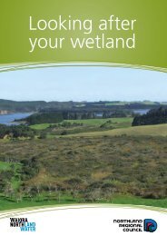
Under the umbrella of its Oranga Whenua programme, Te Roroa is restoring lands retiredfrom pine production. As mentioned previously, Te Roroa also owns and operates the<strong>Waipoua</strong> Campground, Visitor Centre and café and there are two marae located in the<strong>Waipoua</strong> Valley (Pānanawe and Matatina).2.2.5 EconomicThe main economic value of the <strong>Waipoua</strong> <strong>River</strong> and <strong>Waipoua</strong> Forest is tourism:“<strong>Waipoua</strong> Forest is an iconic <strong>Northland</strong> and New Zealand tourist destination…The ruggedwest coast of <strong>Northland</strong> is marketed as the ‘Kauri Coast’ and the giant kauri trees form one ofthree strategic sites for the <strong>Northland</strong> tourism industry. Both <strong>Waipoua</strong> Forest and TrounsonKauri Park are identified as icon areas and attractors in the <strong>Northland</strong> Tourism Strategy. Up to100,000 [sic] people per year visit the Tāne Mahuta site. Tourism flows in the forest are highlyseasonal, with the peak period in the summer season from December to February. Recentsurveys have shown that overseas tourists make up the majority (62%) of visitors to theforest, with people from Auckland making up the majority (38.5%) of domestic visitors.” (DOC2011, p. 22)The <strong>Waipoua</strong> Visitor Centre has a small gallery, café and a retail/reception area withcampsite, cabin and house accommodation in the adjacent <strong>Waipoua</strong> Camping Ground.Since 2000, there has been an average of 80,000 visitors per year (DOC 2011).Individuals or businesses undertaking commercial activities or research in <strong>Waipoua</strong> Foresthave to apply for a concession because it is public conservation land (DOC 2012). Aconcession is a permit, licence or lease that allows commercial or organised non-profitactivities and/or the occupation of land/building of structures. Approximately 20 concessionscurrently operate in this area for guided activities, grazing and scientific research (DOC2011).2.2.6 Other valuesAdditional to the historical values of significance to Maori already identified in section 2.2.4,there are more historical values of the <strong>Waipoua</strong> <strong>River</strong> and surrounding catchment. There area total of 230 archaeological sites registered in the New Zealand ArchaeologicalAssociation’s Database as being in the <strong>Waipoua</strong> <strong>River</strong> catchment. They are all locateddownstream of the SH bridge and are concentrated around the river (DOC 2011). About 170are identified as Maori archaeological sites (see section 2.2.4). The remaining 60 sites aremainly related to the kauri gum-digging and logging history of the area, including gum-holes,camps, horse tracks and a house/gum store. There is also one actively managed historicalsite: the Kauri Lookout, constructed by the New Zealand Forest Service in the 1960s (DOC2011).Other values of the <strong>Waipoua</strong> <strong>River</strong> include water supply, mainly for stock, and electricitygeneration. However, information on these uses is very limited and is not likely to be ofsignificant nature, given the remoteness of the area and low population.18