draft revised kaihu river management plan - Northland Regional ...
draft revised kaihu river management plan - Northland Regional ...
draft revised kaihu river management plan - Northland Regional ...
- No tags were found...
You also want an ePaper? Increase the reach of your titles
YUMPU automatically turns print PDFs into web optimized ePapers that Google loves.
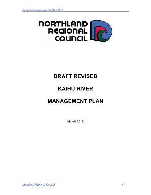
Revised Kaihu Management Plan March 2010DRAFT REVISEDKAIHU RIVERMANAGEMENT PLANMarch 2010<strong>Northland</strong> <strong>Regional</strong> Council - 1 -
Revised Kaihu Management Plan March 2010REVISED KAIHU RIVER MANAGEMENT PLANTABLE OF CONTENTS1. EXECUTIVE SUMMARY...........................................................................................31.1. REVISED MANAGEMENT PLAN .............................................................................31.2. KAIHU RIVER FLOOD MANAGEMENT SCHEME LIAISON COMMITTEE .............32. INTRODUCTION.......................................................................................................52.1. OBJECTIVES............................................................................................................53. PROPOSED LEVEL OF SERVICE FOR MANAGEMENT PLAN 2010-2016 ..........54. PROPOSED ANNUAL WORK PROGRAMMES.......................................................65. SCHEME FUNDING..................................................................................................66. DESCRIPTION OF KAIHU RIVER MANAGEMENT AREA ......................................77. RIVER MANAGEMENT ISSUES ..............................................................................87.1. Upper catchment.......................................................................................................87.2. Kaihu to Ahikiwi.........................................................................................................87.3. Ahikiwi to Waihue Road, Mamaranui ........................................................................97.4. Waihue Road, Mamaranui, to the Rotu Bottleneck ...................................................97.5. Rotu Bottleneck to Parore .......................................................................................107.6. Parore to the Northern Wairoa River.......................................................................117.7. Conclusions.............................................................................................................118. RIPARIAN MANAGEMENT.....................................................................................12REFERENCE..................................................................................................................13APPENDIX 1...................................................................................................................14APPENDIX 2.................................................................................................................- 1 -<strong>Northland</strong> <strong>Regional</strong> Council - 2 -
Revised Kaihu Management Plan March 20101. EXECUTIVE SUMMARYDRAFT REVISED KAIHU RIVER MANAGEMENT PLAN1.1. REVISED MANAGEMENT PLANThis Plan sets out policies for managing the existing Kaihu River ManagementScheme for the next five years from 2010 to 2015. It provides for: continuation of the channel and maintenance work below RotuBottleneck; excavation of accumulated sediment from the inside of bends in thechannel between Mamaranui and Rotu Bottleneck; clearance of log jams and fallen trees between Kaihu and Mamaranui; removal of willows and accumulated gravel that is reducing the capacityof the channel for 400 metres upstream and downstream of Woods RoadBridge, Kaihu.Figure 1 defines the catchment area of the Kaihu River. Section 1 is DuckCreek to, to the Northern Wairoa River confluence. Section 2 is the lower <strong>river</strong>downstream of Parore Road Bridge to Duck Creek, Section 3 is the <strong>river</strong>between the Rotu Bottleneck and Parore Road and Section 4 is the section of<strong>river</strong> between Waihue Road and the Rotu Bottleneck. Section 5 is the length of<strong>river</strong> between Ahikiwi and Waihue Road. Section 6 is the Kaihu River fromKaihu to Ahikiwi.1.2. KAIHU RIVER FLOOD MANAGEMENT SCHEME LIAISON COMMITTEEThe Kaihu River Flood Management Scheme Liaison Committee has assistedthe <strong>Northland</strong> <strong>Regional</strong> Council in preparing the Draft Revised Kaihu RiverManagement Plan. This Committee, a subcommittee of the Council’s LandcareCommittee, comprises: a <strong>Northland</strong> <strong>Regional</strong> Councillor; a Kaipara District Councillor who, in particular, represents the interests ofthe urban area of Dargaville-Mangawhare; an iwi representative; three landholder representatives, one from the upper catchment, onefrom the floodplain downstream of Waihue Road, Mamaranui, and onefrom the floodplain upstream of Waihue Road.Under its Terms of Reference, contained in APPENDIX 1, this Committee willalso assist the Council to implement the Revised Management Plan.<strong>Northland</strong> <strong>Regional</strong> Council - 3 -
Revised Kaihu Management Plan March 2010Figure 1 Kaihu Catchment and River manageemnt Sections.<strong>Northland</strong> <strong>Regional</strong> Council - 4 -
Revised Kaihu Management Plan March 20102. INTRODUCTION2.1. OBJECTIVESThe Revised Kaihu River Management Plan sets out the guidelines under whichthe landholders and residents of the Kaihu River catchment, the Kaipara DistrictCouncil and the <strong>Northland</strong> <strong>Regional</strong> Council will manage the Kaihu River and itsfloodplain. The Plan sets out to:Reduce the threat to residential development in the settlements of Kaihu,between Kaihu and Ahikiwi, and in Dargaville-Mangawhare.Reduce the sediment load in the Kaihu River through <strong>river</strong> <strong>management</strong>and soil conservation initiatives.Maintain the Kaihu River according to agreed performance standards.3. PROPOSED LEVEL OF SERVICE FOR MANAGEMENT PLAN 2010-2016Section 1 & Section 2 - Parore to Northern Wairoa River Maintain an effective channel in the Kaihu River, by machine cleaningaccumulated sediment and spraying infestations of ricegrass and giant rush,to within a range of plus or minus 10% of the 2011 cross sectional profile 1dimensions of the Kaihu River Scheme.The Kaipara District Council will be responsible for constructing andmaintaining any protection works required for the Dargaville township.Section 3 – Rotu Bottleneck to Parore Maintain an effective channel in the Kaihu River, by machine cleaningaccumulated sediment and spraying infestations of ricegrass and giant rush,to within a range of plus or minus 10% of 2011 cross sectional profile.Section 4 – Waihue Road, Mamaranui, to Rotu Bottleneck Maintain an effective channel in the Kaihu River between Mamaranui andRotu Bottleneck to within plus or minus 10% of the 2011 cross sectionalprofile dimensions.Reduce streambank erosion by maintaining the streambanks as and whererequired and by removing sediment as it accumulates on the banks on theinside of bends. Remove significant obstructions within the <strong>river</strong> channel that may beobstructing flood flows and/or have potential to exacerbate stream bankerosion;1There is a provision in the Kaihu River Work Programme of 2010-2011 of Cross Sectional Profiling. This provision is forevery five years.<strong>Northland</strong> <strong>Regional</strong> Council - 5 -
Revised Kaihu Management Plan March 2010Section 5 – Ahikiwi to Waihue Road, Mamaranui Reduce stream bank erosion by maintaining gravel or encouraging theremoval of gravel as it accumulates in the channel.Inspect the <strong>river</strong> annually to check for unwanted willows, poplars and fallentrees/debris blockages, removing these as required.Section 6 – Whatoro to AhikiwiInspect the <strong>river</strong> annually to check for unwanted willows, poplars and fallentrees/debris blockages, removing these as required. Manage the gravel resource in the <strong>river</strong> for 300 metres upstream and 200metres downstream of Wood Road, to reduce stream bank erosion.4. PROPOSED ANNUAL WORK PROGRAMMESRefer to Section 5 of the Kaihu 6-yr River Maintenance Plan which is in APPENDIX .Employment of contractors for works under the Management Plan will follow theprocedures set out in the <strong>Northland</strong> <strong>Regional</strong> Council Tenders Policy.5. SCHEME FUNDINGTo fund channel maintenance work carried out in accordance with the Kaihu RiverFlood Management Plan by way of a targeted and differentiated rate based on thelevel of benefit to land and rating units, falling within the Kaihu River Managementarea. The Council will set the rate differentially as follows:1. Class A – land on the floodplain and side valleys downstream of the RotuBottleneck. Rate is applied per hectare of land.2. Class B – land on the floodplain and tributary side valleys between Ahikiwiand the Rotu Bottleneck. Rate is applied per hectare of land.3. Catchment Rate – balance nof land within the Kaihu River rating area notfalling within Classes A and B. Rate is applied per hectare of land.4. Urban Contribution – a contribution from Kaipara Disctrict Council instead ofa separate rate per property.5. The rating classifications and the rate charged are illustrated as follows(based on 2010/11):<strong>Northland</strong> <strong>Regional</strong> Council - 6 -
Revised Kaihu Management Plan March 2010ClassKaihu River Flood Management Rate: descriptionDescriptionRate perHa EXClGSTABCatchment RateUrban ContributionLand on the floodplain and side valleys downstream of theRotu Bottleneck.Land on the floodplain and tributary side valleys betweenAhikiwi and the Rotu BottleneckBalance of rateable land within the Kaihu River rating areaA Contribution from Kaipara District Council instead of aseparate rate per property$22.28$11.14$1.67$4,951 perannumHow much is the rate?The estimated targeted Kaihu River Management Rate amounts to $78,612 ExclGST in the 2010-2011 financial year. The revenue sought from each category ofrateable land will be as follows:Total Revenue $ Excl GSTClass AClass BCatchment RateUrbanContributionTotal RateHow is the rate applied?$25,022$17,215$31,424$4,951$78,612The rate is applied 100% to Kaihu River Management works which forms part ofthe River Management Activity.6. DESCRIPTION OF KAIHU RIVER MANAGEMENT AREAThis Revised Management Plan, while considering the whole of the Kaihu Rivercatchment, deals primarily with the <strong>management</strong> of a community <strong>river</strong> <strong>management</strong>scheme on the Kaihu River downstream of the confluence of the Waima River andthe Mangatu Stream.The Kaihu River catchment comprises 354 square kilometres on the western slopesof the Tutamoe Plateau and the old volcanic Aranga downland between Whatoro andMaunganui Bluff. Several major tributaries meet to form the Kaihu River immediatelyupstream of the small settlement of Kaihu, and the <strong>river</strong> then flows in a broad valley<strong>Northland</strong> <strong>Regional</strong> Council - 7 -
Revised Kaihu Management Plan March 2010on the inland edge of former sand dunes and terraces that extend southwards fromthe Maunganui Bluff to the Northern Wairoa River to the tip of Pouto Peninsula. Thefloodplain and associated terraces of the Kaihu River extend for 29 kilometresbetween Kaihu and Dargaville and vary in width from 1.5 km at Mamaranui, reducingto 0.4 km at the Rotu Bottleneck and widening again to 1.0 km wide just upstream ofParore. The Kaihu River joins the Northern Wairoa River in Dargaville.The <strong>river</strong> is joined by a number of small east bank (left bank when lookingdownstream) tributaries between Kaihu and the Rotu Bottleneck. These streamsdrain the western slopes of Tutumoe and the range of hills separating the Kaihu andAwakino Valleys. Sediment from the Kaihu River has trapped several right or westbanktributary valleys draining the old dunes and sand terraces between the KaihuValley and the West Coast. Peat has accumulated in these swampy valleys. Withdrainage for farming, the peat has shrunk, creating basins in which water can pondfor some time following heavy rain. Floodwaters from the Kaihu River spill out intothese basins downstream of Waihue Road, Mamaranui.7. RIVER MANAGEMENT ISSUESThe <strong>Northland</strong> River Management Policy notes that it is neither practical norfinancially feasible to prevent all flooding in <strong>Northland</strong>. While improved <strong>river</strong><strong>management</strong> can reduce the depth, duration and frequency of flooding, it isinevitable that land on floodplains will periodically be inundated. The overall goal forthe Kaihu River Management Plan is to manage the <strong>river</strong> and the flooding from the<strong>river</strong> to avoid damage to buildings or threats to human life, to maintain road accessand to optimise agricultural production.7.1. Upper catchmentMuch of the upper catchment of the Waima River comprises rolling old volcanichill country with deeply weathered soil. While steeper slopes are prone toslipping during high intensity rainstorms, the most common forms of soil erosionare streambank erosion and gullying. These two forms of erosion cause largevolumes of sand, silt and red colloidal clay to be discharged into the <strong>river</strong>system. So too do overgrazing and pugging of these volcanic clay soils. Thecoarser material, sand and silt, is deposited on the berms of the <strong>river</strong> and on theinside of bends between Mamaranui and Rotu Bottleneck, causing the <strong>river</strong> tomeander and erode the opposite bank. This accumulated material and the finerclay deposited in the tidal reaches of the Kaihu River between the RotuBottleneck and Dargaville must be periodically removed to maintain the capacityand alignment of the channel and to prevent streambank erosion.7.2. Kaihu to AhikiwiThe Waima River flows within a narrow gorge until it joins with the MangatuStream to form the Kaihu River about 3 km north of Kaihu. In the 3 km betweenKaihu and Ahikiwi, the <strong>river</strong> has formed distinct <strong>river</strong> terraces with floodwatersconfined primarily to the lowest or most recent terrace. Coarse <strong>river</strong> gravel hasbuilt up in the bed of the Kaihu River, reducing the capacity of the channel andincreasing the risk of an overflow in the settlement of Kaihu. In Cyclone Bola,the <strong>river</strong> overflowed both its banks, flowing around the Kaihu Hall, through the<strong>Northland</strong> <strong>Regional</strong> Council - 8 -
Revised Kaihu Management Plan March 2010old railway station site, and across the football fields and in front of the KaihuHotel, and back into the <strong>river</strong> a few hundred metres downstream of Kaihu. Thegravel load in the <strong>river</strong> needs to be managed for about one kilometre upstreamof Kaihu and three kilometres downstream so as to maintain sufficient capacityin the channel to reduce the risk of an overflow amongst the houses.For two kilometres downstream of Kaihu, the <strong>river</strong> is choked with willow (Salixfragilis) trees. These trees are obstructing the flow, diverting flood flows into thebanks causing streambank erosion and accumulating gravel. During floods theycollect debris, damming the flow and diverting the floodwaters out of the channelacross the floodplain. Streambank erosion is threatening and causing slumpingof State Highway 12 and affecting farmland and orchards on both banks of the<strong>river</strong>.7.3. Ahikiwi to Waihue Road, MamaranuiDownstream of Ahikiwi, as far as the Rotu Bottleneck, the <strong>river</strong> floods out over amuch wider floodplain on which there is clear evidence of a number of older <strong>river</strong>channels, showing where the <strong>river</strong> has meandered backwards and forwardsacross the floodplain. Sediment carried by the <strong>river</strong> has been deposited alongthe banks of these old channels, making this <strong>river</strong>bank land higher than thesurrounding floodplain and clear of water when the rest of the floodplain isinundated.Poplar trees were <strong>plan</strong>ted along the banks of the Kaihu River in the early 1900sto control streambank erosion. Some of these trees remain but are becomingover-mature and need to be removed where they are at risk of falling across the<strong>river</strong>. Others have suckered where their roots have been exposed along the<strong>river</strong>banks and these new tree trunks are impeding the flow of water in thechannel. The soil on the banks through this reach of the <strong>river</strong> is highly erodibleso the removal of these poplars growing in the channel needs to be undertakenin a way that minimises the risk of erosion.7.4. Waihue Road, Mamaranui, to the Rotu BottleneckThe Kaihu River Scheme was constructed in three stages. The section of <strong>river</strong>between Waihue Road and the Rotu Bottleneck, a point at which the floodplainnarrows and the <strong>river</strong> begins to be influenced by the tide, was Stage 3 of theearlier scheme. Downstream of Waihue Road, the gradient of the <strong>river</strong>bedreduces and the meander pattern of the <strong>river</strong> increases, so that as it approachesthe Rotu Bottleneck, the <strong>river</strong> is following a very convoluted course, looping backon itself several times.All trees have been removed from the <strong>river</strong>banks between Waihue Road and theupstream side of the wetland forest immediately upstream of the RotuBottleneck. Grass extends well down the banks of the <strong>river</strong> and when this grassbecomes rank, it traps large volumes of sediment each time there is a fresh inthe <strong>river</strong>.Immediately upstream of the Rotu Bottleneck is a natural ponding area wherethe grade of the <strong>river</strong>bed flattens, sediment is deposited and floodwaters are<strong>Northland</strong> <strong>Regional</strong> Council - 9 -
Revised Kaihu Management Plan March 2010ponded between tides. There are still remnants of the original swamp forestvegetation in this area. It was the intention of the original Kaihu River ControlScheme that the <strong>river</strong> channel should remain relatively unmodified at the RotuBottleneck to impede the flow of floodwaters, so protecting the developedfarmland downstream of this point and the urban area of Dargaville-Mangawhare.There are other stopbanks on the upstream bank of this old Kaihu River loopwhich have been authorised by way of resource consents.7.5. Rotu Bottleneck to ParoreParore is at another narrow point in the valley, where the floodplain narrows toabout 300 metres wide before widening again as it approaches the outskirts ofDargaville. The <strong>river</strong> through this 6km Rotu to Parore stretch has been slightlymodified by being widened and straightened, and accumulated sediment hasbeen dredged under Stage 2 of the former Kaihu River Scheme. Infestations ofManchurian ricegrass (Zizania latifolia) and giant rush (Schoenoplectuscalifornicus) occur through this stretch, increasing the need for more frequentmachine cleaning of the channel, both to remove the obstruction caused by thericegrass and giant rush growing in the channel and the sediment trapped bythis weed.The material removed from the channel has been deposited in spoil heaps closeto the <strong>river</strong>banks. Over time, the spoil heaps have in places been linkedtogether to form stopbanks running parallel to the channel. The formation ofthese stopbanks is contrary to the original scheme design and has not beenauthorised under the Soil Conservation and Rivers Control Act 1941, the Waterand Soil Conservation Act 1967 or the Resource Management Act 1991.Whereas the floodwaters from the Kaihu River previously spilled out across thefull floodplain between the Rotu Bottleneck and Parore, they are now largelyconfined to the <strong>river</strong> and the narrow strip of bermland between the banks. Thebanks/spoil heaps may also be preventing water that has overflowed into thearea between the <strong>river</strong> and SH12 from flowing back into the <strong>river</strong>. As notedabove, these banks have been formed from spoil heaps and are neither wellsited or of consistent height, neither are they complete.Babylon Stream and Rotu Stream, both west (right) bank tributaries were alsoenlarged as part of the Kaihu River Scheme undertaken in the mid-1960s.These channels carry floodwaters that have spilled out of the Kaihu River andinto the side valleys, back into the Kaihu River. They have stopbanks alongtheir sides in some areas.The old Donnelly’s Crossing Railway embankment also acts as a stopbankthrough this section of the valley, restricting the spread of floodwaters from theKaihu River into the side valleys, and restricting the flow of these pondedfloodwaters back into the Kaihu River.<strong>Northland</strong> <strong>Regional</strong> Council - 10 -
Revised Kaihu Management Plan March 20107.6. Parore to the Northern Wairoa RiverThe lower section of the <strong>river</strong>, included in Stage 1 of the original scheme,extends from Parore to where the <strong>river</strong> enters the Northern Wairoa Riverbetween Dargaville and Mangawhare. This reach was reconstructed andstraightened in the late 1950s.This lower section of the <strong>river</strong> is strongly influenced by the tide and sedimentfrom the Northern Wairoa River has been deposited along the banks of both theKaihu and Northern Wairoa River, making the adjoining land as high as or evenhigher than the bermland in the reach covered by Stage 2, between Rotu andParore. Parore West Road crosses the narrow point in the valley on a raisedembankment which helps to control floodwaters entering the lower valley.Parore Road has been raised since it was overtopped in the flood caused byCyclone Bola and may now be acting as a dam.The <strong>river</strong> through this reach is partially stopbanked on the east (left) bank, andan area of the floodplain immediately downstream of Parore Road Bridge andeast of the <strong>river</strong> is protected by the Donnelly’s Crossing railway embankment.The Kaipara District Council is currently undertaking improvements to the banksbetween Beach Road and the Northern Wairoa confluence, including theconstruction of stopbanks to fill gaps and low spots on both banks of the KaihuRiver. Without this remedial work, there is a very real risk of a major KaihuRiver flood entering Dargaville along Valley Road and Beach Road. There isalso a risk of floodwaters spilling over the west (right) bank of the <strong>river</strong>, throughMemorial Park and into the low-lying area of Mangawhare.The banks of the <strong>river</strong> are heavily infested with Manchurian ricegrass and thechannel with giant rush in this reach. Sediment deposited in this dense mass offoliage has to be removed at regular intervals between the Parore Bridge andsome 4.0 km from the <strong>river</strong> mouth. Computer modeling to date indicates thatthe ricegrass and rush infestations in the lower 4.0 km of the <strong>river</strong> restrict theflow of water, causing a backwater effect as far as Parore. Clearing thericegrass and accumulated silt benefits Sections 1 and 2 of the original scheme,that is between Rotu Bottleneck and the Northern Wairoa River confluence.Controlling ricegrass in this reach will lower the water level during floods andreduce the height of stopbanks <strong>plan</strong>ned to protect Dargaville and Mangawhare.7.7. ConclusionsManagement of flooding in the Kaihu River Valley involves both managingfloodwaters and managing the sediment load of the <strong>river</strong>. There is a need tomanage gravel in the <strong>river</strong> channels upstream of Ahikiwi to maintain capacity inthe channels and so reduce the risk of flood overflows and of streambankerosion threatening dwellings in Kaihu. Soil conservation measures within theupper catchment will help to reduce the amount of silt carried by the <strong>river</strong>, whichhas to be regularly removed from the channel downstream of the RotuBottleneck.Within the middle reaches of the <strong>river</strong>, from Ahikiwi through to the RotuBottleneck, fallen trees, accumulated gravel and the build-up of sediment on the<strong>Northland</strong> <strong>Regional</strong> Council - 11 -
Revised Kaihu Management Plan March 2010inside of bends can all increase the incidence of streambank erosion. Throughthis section, <strong>river</strong> <strong>management</strong> may involve little more than maintaining a stablechannel, and accepting that floodwaters will periodically overflow the <strong>river</strong>banks.Downstream of the Rotu Bottleneck, the <strong>river</strong> channel must be frequentlymaintained to remove fine sediment brought down from the upper catchment.Even with extensive soil conservation works in the upper catchment and areduction in sediment load, this channel maintenance work will still be required.The impact of ponding immediately above the Rotu Bottleneck and in severalother areas on the floodplain is not well understood. Nor is the effect ofstopbanks, floodgates, the railway embankment and roads, all of which preventfloodwaters flowing freely across the floodplain.8. RIPARIAN MANAGEMENTThe major objective of this Plan is to reduce the impact of flooding on both primaryproduction and on buildings in Kaihu, Dargaville and Mangawhare. In achievingthese objectives, however, the Plan must have regard for the riparian <strong>management</strong>provisions of the operative <strong>Regional</strong> Water and Soil Plan for <strong>Northland</strong>, and the<strong>Northland</strong> <strong>Regional</strong> Action Plan of the National Clean Streams Accord. The form ofthe riparian <strong>management</strong> will vary from one part of the <strong>river</strong> system to another and,in some areas, optimum riparian <strong>management</strong> for flood control may conflict withoptimum <strong>management</strong> for water quality and/or in-stream values. In implementing thePlan, the <strong>Regional</strong> Council will work with landholders, community groups and otherstakeholders to develop riparian <strong>management</strong> regimes that protect stream banksfrom erosion, protect and enhance instream wildlife habitats and improve waterquality, but still optimise flood flows in the streams and <strong>river</strong>s and their berms.In the upper catchment of all tributary streams, the objective will be to encouragethe establishment of dense and healthy streamside vegetation to traps sedimentand control streambank erosion.Through the gorge areas on each stream, the Plan will encourage the exclusionof stock from areas of remnant bush, pest control measures will be encouragedand landholders encouraged to place the land under protective covenants. Between the confluence of the Kaihu River and the Mangatu Stream andMamaranui, weed species such as wild ginger, and pampas grass in the <strong>river</strong>channel will be controlled, and willow trees will need to be removed from withinthe channel where they are trapping sediment and gravel and blocking the <strong>river</strong>channel. So too will willow and poplar (or any other) trees that are obstructingflow in the channel. Landholders will be encouraged to exclude stock from thestreams and immediate <strong>river</strong>banks.Downstream of the Rotu Bottleneck, the <strong>river</strong> flows in an artificial channel whichmust be cleared of accumulated sediment and weed. The primary function of thebermland in this stretch is as a floodway to efficiently convey floodwaters. Theberms between any stopbanks and the <strong>river</strong> and the stopbanks themselves needto be carefully grazed to maintain a dense sward of grass but must not beovergrazed.<strong>Northland</strong> <strong>Regional</strong> Council - 12 -
Revised Kaihu Management Plan March 2010REFERENCE1. Kaihu River Flood Management Scheme Liaison Committee Terms ofReference<strong>Northland</strong> <strong>Regional</strong> Council - 13 -
Revised Kaihu Management Plan March 2010APPENDIX 1KAIHU RIVER FLOOD MANAGEMENT SCHEME LIAISON COMMITTEETerms of ReferenceReporting to:Composition:The Landcare Committee of the <strong>Northland</strong> <strong>Regional</strong> CouncilThe Liaison Committee is a sub-committee of and appointed by the<strong>Northland</strong> <strong>Regional</strong> Council and shall comprise:One <strong>Northland</strong> <strong>Regional</strong> Councillor who will chair the meetingOne Kaipara District Councillor (who also represents the residents ofDargaville)One member nominated by Te RoroaOne member nominated to represent Te Houhanga MaraeThree representatives of the ratepayers of the <strong>river</strong> catchment, onefrom each area:Area 1 (Floodplain Rotu Bottleneck to Dargaville)Area 2 (Floodplain Confluence of Whatoro and Mangatu Streams toRotu Bottleneck)Area 3 (Catchment area beyond the floodplain)Chairperson:The Chairperson of the Committee shall be elected from amongstmembers of the Committee on an annual basis.LengthTerm:MeetingFrequency:StandingOrders:Objective:Functions:ofAppointments will be made for a term of three years, in sequence withthe local government elections, or until earlier disqualification, death orresignation. Should any of the latter three events arise, replacementappointees may be made by the <strong>Northland</strong> <strong>Regional</strong> Council.As required, but no less than three times each year.Meetings will be run in accordance with New Zealand Standard ModelStanding Orders (NZS 9202:2001).To advise and make recommendations to the <strong>Northland</strong> <strong>Regional</strong>Council, via the Landcare Committee, on all matters pertaining to thedevelopment and implementation the Kaihu River ManagementScheme.<strong>Northland</strong> <strong>Regional</strong> Council - 14 -
Revised Kaihu Management Plan March 2010The Kaihu River Management Plan Liaison Committee is an advisory committee of the<strong>Northland</strong> <strong>Regional</strong> Council and has no delegated authority or specific powers. Itsfunctions are to:1. Provide a stakeholder forum for the development of policies and <strong>plan</strong>s for the<strong>management</strong> of flooding within the Kaihu River catchment.2. Enable stakeholders to participate in the ongoing <strong>management</strong> of flood controlwith the Kaihu River catchment.3. Facilitate communications between the <strong>Northland</strong> <strong>Regional</strong> Council, which isultimately responsible for the development and implementation of the Plan, andthe residents and landholders within the catchment.4. Advise the <strong>Northland</strong> <strong>Regional</strong> Council on all matters relating to the developmentand implementation of the Kaihu River Management Plan.Specific tasks will include:1. Assisting the <strong>Northland</strong> <strong>Regional</strong> Council to develop and adopt a ManagementPlan for the <strong>management</strong> of flooding and erosion within the catchment of theKaihu River.2. Annually reviewing the priority and order of works within the <strong>management</strong> <strong>plan</strong>,ensuring that works are being undertaken in the order set out in the Plan and tothe standards specified in the Plan or, when necessary, recommending changesto the Plan.3. Each year, reporting on performance against the past year’s work <strong>plan</strong> andrecommending to the <strong>Regional</strong> Council an annual works <strong>plan</strong> and budget for theforthcoming financial year.<strong>Northland</strong> <strong>Regional</strong> Council - 15 -
<strong>Northland</strong> <strong>Regional</strong> CouncilAPPENDIX 2KAIHU RIVER MAINTENANCE PLAN 2010-2016Kaihu River Maintenance Plan 2010-2016 - 1 -
<strong>Northland</strong> <strong>Regional</strong> CouncilKAIHU RIVER MAINTENANCE PLAN 2010-2016<strong>Northland</strong> <strong>Regional</strong> CouncilKaihu River Maintenance Plan 2010-2016 - 2 -
<strong>Northland</strong> <strong>Regional</strong> CouncilTABLE OF CONTENTS1. Objective ...............................................................................................................- 2 -2. Description of Kaihu River.....................................................................................- 2 -2.1. The Lower Sections - Section 1 - 2 .......................................................................- 3 -2.2. Parore to Rotu - Section 3.....................................................................................- 3 -2.3. Narrow Floodplain - Section 4...............................................................................- 3 -2.4. Poplar Trees - Section 5 .......................................................................................- 4 -2.5. Trapped Gravels - Section 6 .................................................................................- 4 -3. River Maintenance Plan ........................................................................................- 4 -3.1. Spray Ricegrass....................................................................................................- 4 -3.2. Machine Clean ......................................................................................................- 4 -3.3. Clean Inside Bends ...............................................................................................- 5 -3.4. Spray Willows........................................................................................................- 5 -3.5. Remove Fallen Debris That Dam The River .........................................................- 5 -3.6. Gravel Management..............................................................................................- 5 -3.7. River Cross Section Survey ..................................................................................- 6 -4. Proposed Annual Work Programme and Indicative Costings ...............................- 6 -Reference:.......................................................................................................................13Kaihu River Maintenance Plan 2010-2016 - 1 -
<strong>Northland</strong> <strong>Regional</strong> CouncilKAIHU RIVER MAINTENANCE PLAN 2010-2016<strong>Northland</strong> <strong>Regional</strong> Council1. ObjectiveEstablish an annual <strong>river</strong> maintenance programme for the Kaihu Riverfrom Year 2010 to Year 2016. This programme will serve as a yearlyschedule of activities in relation to <strong>river</strong> maintenance work in Kaihu.2. Description of Kaihu RiverFor <strong>river</strong> <strong>management</strong> purposes the Kaihu River is divided into sixsections. The sections are defined in accordance with the relevant <strong>river</strong>works. Figure 1 shows the different sections of the <strong>river</strong>:Figure 2 Kaihu River Secton Map.Kaihu River Maintenance Plan 2010-2016 - 2 -
<strong>Northland</strong> <strong>Regional</strong> CouncilTable 2 describes the boundaries of the different sections of the KaihuRiver.Table 2. Sections of the Kaihu River as divided for <strong>river</strong> <strong>management</strong> purposes.SECTION DESCRIPTION ApproximateLength (m)1 From Northern Wairoa to Okahu (Duck Creek)2 From Okahu (Duck Creek) to Parore Road3 From Parore Road to Rotu Bottleneck4 From Rotu Bottleneck to Waihue Road5 From Waihue Road to Ahikiwi6 From Ahikiwi to Kaihu River (Confluence withWaima River)1,5605,5507,6507,9808,7608,1602.1. The Lower Sections - Section 1 - 2The lower sections of the <strong>river</strong>, comprised of Sections 1 and 2, hadextensive reconstruction and meander removal work done in the late1950s. The banks from the lower end, including sections of bank uptowards the Rotu Bottleneck, are infested with Manchurian Ricegrass,which accumulates sediment requiring regular machine cleaning of thebanks or spraying with herbicide.2.2. Parore to Rotu - Section 3Under Stage 2 of the former Kaihu River Scheme, Section 3 which isstretch between Parore and Rotu has been modified by increasing thechannel width and removing meanders. Spoil heaps from the workshave been deposited close to the <strong>river</strong> banks and over time werelinked to became stopbanks running parallel to the channel.Also part of the Kaihu River Scheme, Enlargement of Babylon Streamand Rotu Stream which were both west bank tributaries wereundertaken in the 1960s. They served as spillway out of Kaihu Riverand into side valleys and back to Kaihu River.The old Donnelly’s Crossing Railway embankment also acts as astopbank through this section of the valley, restricting the spread offloodwaters from the Kaihu River into the side valleys, and restrictingthe flow of these ponded floodwaters back into the Kaihu River.2.3. Narrow Floodplain - Section 4Section 4 which is the channel between Rotu and Waihue. Theoriginal swamp forest vegetation immediately upstream of theKaihu River Maintenance Plan 2010-2016 - 3 -
<strong>Northland</strong> <strong>Regional</strong> Councilbottleneck where the <strong>river</strong>bed flattens is still evident, serving as aponding area and sediment trap.2.4. Poplar Trees - Section 5Section 5 which is the channel between Waihue Road and Ahikiwi sitson a much wider floodplain which manifests a number of older <strong>river</strong>channels. In the early 1900s, Poplar trees were <strong>plan</strong>ted in this sectionfor the purpose of controlling stream bank erosion. At present, theover mature trees risk falling into the <strong>river</strong>, contributing to debris damformation and accelerating stream bank erosion. .2.5. Trapped Gravels - Section 6As Waima <strong>river</strong> approaches a narrow gorge, it joins Mangatu Streamto form Kaihu River. In Section 6, which is the channel betweenAhikiwi to the convergence with Waima River, coarse <strong>river</strong> gravel hasbuilt up in the bed causing a reduction of the capacity of the channeland the risk of an overflow in the settlement of Kaihu. The gravel loadin the <strong>river</strong> needs to be managed for about one kilometre upstream ofKaihu and three kilometres downstream so as to maintain sufficientcapacity in the channel to reduce the risk of an overflow. In thissection the <strong>management</strong> of willow trees (Salis fragilis) is required tominimise the formation of gravel islands which can exacerbate streambank erosion,3. River Maintenance PlanRegular maintenance work that has been done since 2006 comprising ofricegrass and willow spraying, machine cleaning of banks, blockageremoval and gravel <strong>management</strong> is proposed over the next six years,along with works to improve flow efficiency of the Kaihu River where thisshallows near the confluence with Okahu Creek.3.1. Spray RicegrassSpraying Manchurian ricegrass on both banks in the lower sectionfrom the confluence with the Northern Wairoa River to Duck Creek,where slips and the Dargaville floodwall obstruct machine cleaning, isproposed. This option is more efficient than cleaning with a hydraulicexcavator, given issues with access and bank instability associatedwith this section of the <strong>river</strong>. The objective is to eradicate the grasscompletely, which will reduce accumulation of sediments on thebanks. This option will require a long term commitment to ensureadequate control of the ricegrass, because of the tenacity of the <strong>plan</strong>tto rapidly grow and recolonise areas.3.2. Machine CleanAnnual machine cleaning of the banks in the lower sections of the <strong>river</strong>is proposed in order to maintain <strong>river</strong> cross section capacity, which isKaihu River Maintenance Plan 2010-2016 - 4 -
<strong>Northland</strong> <strong>Regional</strong> Councilpotentially compromised by sediment accumulation due to trapping ofsediment in ricegrass on the banks. Removal of bed sediments is notpractical, given constraints of the reach of available machinery andcost implications.In Section 1, machine cleaning will be done on both banks annuallyexcept for a section on the left bank where the floodwall exists and asection on the right bank where a slump compromises machineaccess. In Section 2, machine cleaning will be done annually on bothbanks. In Section 3, machine cleaning will be done on one side of the<strong>river</strong> annually, commencing with the left bank in Year 1, and alternatingbetween right and left banks on subsequent years.3.3. Clean Inside BendsFrom Rotu Bottle Neck to Waihue Road the channel meanders andthe <strong>river</strong> gradient is low. Excavation of accumulated sediments fromthe inside bends is proposed for this section. This <strong>river</strong> work requiresan annual assessment prior to commencement to prioritise removal forthose bends that would contribute greatest to stream bank erosionand/or loss of assets.3.4. Spray WillowsWillows in the channel which reduce the capacity of the flow and/orresult in potential for debris blockages or streambank erosion requiremaintenance. The maintenance <strong>plan</strong> provides for three years ofspraying in the three upstream sections of Kaihu River.3.5. Remove Fallen Debris That Dam The RiverThe significant debris that dam the <strong>river</strong> specifically in the section fromWaihue Road to Ahikiwi are the fallen mature poplar trees, shootscoming from the exposed roots of the poplar trees along the channeland willows. This <strong>river</strong> maintenance is done annually on the two uppersections of the channel, with an annual assessment undertaken at thecommencement of the works season to identify blockages andprioritise removal.3.6. Gravel ManagementLarger gravel is accumulated upstream of Ahikiwi, reducing in sizedownstream.Where the accumulation of gravel in the channel causes flowobstruction or flow diversion that introduces streambank erosionwhich in turn risk damage to assets, gravel <strong>management</strong> may berequired.Any person who wants to extract gravels from the channel ispermitted as long as the activity falls within the scope of the permittedKaihu River Maintenance Plan 2010-2016 - 5 -
<strong>Northland</strong> <strong>Regional</strong> Councilactivity rules set by the <strong>Regional</strong> Water and Soil Plan for <strong>Northland</strong> 2 .Activities which fall outside the rules such as extracting quantities ofgravel greater than 100 cubic meters in 12 months among othersneed to seek consents from the <strong>Northland</strong> <strong>Regional</strong> Council or rely onexisting consents for gravel extraction such as that held by the<strong>Northland</strong> <strong>Regional</strong> Council.3.7. River Cross Section SurveyEvery five years, a <strong>river</strong> channel cross section survey will beconducted on fifteen locations in the <strong>river</strong> from SH Bridge to RotuBottleneck. This will provide a basis for assessing the effectiveness ofthe maintenance programme and assessing changes in <strong>river</strong> capacityover time. The proposed cross section locations are shown in Figure6.4. Proposed Annual Work Programme and Indicative CostingsThe proposed annual work programme and cost estimates provideinformation on the forecast Kaihu River Maintenance Work. It isessential that there is an annual pre-works assessment of the <strong>river</strong> toconfirm priorities for <strong>river</strong> works that are required. Figures 2-6 andTable 2 show the summary annual programme for each of the <strong>river</strong>sections.2Rule 31.01.01, <strong>Regional</strong> Water and Soil Plan for <strong>Northland</strong>, Page 31-1Kaihu River Maintenance Plan 2010-2016 - 6 -
<strong>Northland</strong> <strong>Regional</strong> CouncilFigure 3: 6-yr River Maintenance in Section 1.Kaihu River Maintenance Plan 2010-2016 - 7 -
<strong>Northland</strong> <strong>Regional</strong> CouncilFigure 4: 6-yr River Maintenance in Section 2.Kaihu River Maintenance Plan 2010-2016 - 8 -
<strong>Northland</strong> <strong>Regional</strong> CouncilFigure 5: 6-yr River Maintenance in Section 3.Kaihu River Maintenance Plan 2010-2016 - 9 -
<strong>Northland</strong> <strong>Regional</strong> CouncilFigure 6: 6-yr River Maintenance in Section 4.Kaihu River Maintenance Plan 2010-2016 - 10 -
<strong>Northland</strong> <strong>Regional</strong> CouncilFigure 7: River Cross Section Survey Location Map.Kaihu River Maintenance Plan 2010-2016 - 11 -
<strong>Northland</strong> <strong>Regional</strong> CouncilTable 2: Kaihu River 6-yr Maintenance Plan.KAIHU RIVER 6-yr MAINTENANCE PLANACTIVITIES Unit Figure Unit 2010-2011 2011-2012 2012-2013 2013-2014 2014-2015 2015-2016Section1 From Northern Wairoa to Okahu (Duck Creek)Clean right bank from SH Bridge to Duck Creek 1,600.00 m 10,000.00 10,000.00 10,000.00 10,000.00 10,000.00 10,000.00Clean left bank from Car Shop to Duck Creek 900.00 m 3,600.00 3,600.00 3,600.00 3,600.00 3,600.00 3,600.00Spray of the grass on both side of the banks 3,122.96 m - 5,000.00 5,000.00 5,000.00 5,000.00 5,000.00Section 2 From Okahu (Duck Creek) to Parore RoadClean right side of the bank 6,000.00 m 10,200.00 10,200.00 10,200.00 10,200.00 10,200.00 10,200.00Clean left side of the bank 6,000.00 m 10,200.00 10,200.00 10,200.00 10,200.00 10,200.00 10,200.00Install three culverts (One Off) 3.00 Unit 2,340.00 - - - - -Section 3 From Parore Road to Rotu BottleneckClean right side of the bank 7,500.00 m - 11,175.00 - 11,175.00 - 11,175.00Clean left side of the bank 7,500.00 m 11,250.00 - 11,250.00 - 11,250.00 -Section 4 From Rotu Bottleneck to Wiahue RoadClean Inside bends LS 5,000.00 5,000.00 5,000.00 5,000.00 5,000.00 5,000.00Spray Willows 7,981.51 m - 2,000.00 1,360.00 660.00 - -Clean Inside bends due fallen sprayed willows - - - - - 1,666.67 1,666.67Section 5 From Wiahue Road to AhikiwiSpray Willows 8,757.38 m - 2,000.00 1,360.00 660.00 - -Clean Inside bends due fallen sprayed willows LS - - - - 1,666.67 1,666.67Section 6 From Ahikiwi to Kaihu River ( Confluence with Waima River)Spray Willows 8,757.38 m - 2,000.00 1,360.00 660.00 - -Clean Inside bends due fallen sprayed willows LS - - - - 2,000.00 2,000.00Stream Blockages ( Provisional Sum) LS 5,000.00 5,000.00 5,000.00 5,000.00 5,000.00 5,000.00River Cross Section Survey ( Every 5 years) LS - 10,000.00 - - - -Labor Charge LS 11,000.00 11,000.00 11,000.00 11,000.00 11,000.00 11,000.00Rates Collection LS 3,300.00 3,300.00 3,300.00 3,300.00 3,300.00 3,300.00Total 71,890.00 90,475.00 78,630.00 76,455.00 79,883.33 79,808.33Kaihu River Maintenance Plan 2010-2016 - 12 -
<strong>Northland</strong> <strong>Regional</strong> CouncilReference:1. Interim Kaihu River Management Plan – <strong>Northland</strong> <strong>Regional</strong> Council -20102. Kaihu River Flood Management Scheme Concept – Barnett & MacmurrayLimited for NRC – June 20093. <strong>Regional</strong> Water and Soil Plan for <strong>Northland</strong> – <strong>Northland</strong> <strong>Regional</strong> Council– 18 August 20044. http://www.nrc.govt.nz/Environment/Weed-and-pest-control/Pest<strong>plan</strong>ts/Manchurian-Rice-Grass/Kaihu River Maintenance Plan 2010-2016 13


